
 California Highways:
Click here for a key to the symbols used. An explanation of acronyms may be found at the bottom of the page.
 Routing
 Suffixed Routings
This route was once signed as I-15E. Much more information on this route is available on the I-15 page.
 Post 1964 Signage History
 In 1963, Route 215 was defined as "Route 60 at Pomona to Route 66
west of Claremont." The route ran along Garey Avenue between US 60 and US 66.
In 1963, Route 215 was defined as "Route 60 at Pomona to Route 66
west of Claremont." The route ran along Garey Avenue between US 60 and US 66.
In 1965, Chapter 1372 deleted this routing.
In 1982, Chapter 681 redefined Route 215 as the future interstate
routing: “Route 15 near Temecula to Route 15 near Devore via San
Bernardino and passing near Riverside.” This was a renumbering of
Route 194.
In 1994, Chapter 1220 clarified the definition: “Route 15 near
Temecula to Route 15 near Devore via Riverside and San Bernardino
and passing near Riverside.”
Note: The postmiles for Route 215 do not go to 0.00 at Temecula; they are at ~ RIV R8.5. The current I-215 alignment was built as two-lane US 395 before 1964. When US 395 became Route 15 and Route 194 in 1974, US 395's postmiles were kept on Route 194. So although the route starts at RIV 8.5, what was RIV 0.00 corresponds to where US 395 started in Riverside county. (h/t to NE2 on AAroads for that information). However, the statewide odometer is what is used for exit numbers, and that does go to 0.0 at I-15.
 Pre 1964 Signage History
 The 1964-1965 routing of Route 215 was LRN 19, and was the pre-1964
Sign Route 71. It was defined in 1909 as what would become LRN 19, running
from Claremont to Riverside. The routing of LRN 19 between Claremont
and Pomona followed Garey Avenue.
The 1964-1965 routing of Route 215 was LRN 19, and was the pre-1964
Sign Route 71. It was defined in 1909 as what would become LRN 19, running
from Claremont to Riverside. The routing of LRN 19 between Claremont
and Pomona followed Garey Avenue.
Sign Route 71 originated at US 66 near Claremont and followed LRN 19
south towards Pomona. From Pomona, Sign Route 71 followed the
entirety of LRN 77 to US 80 near San Diego. 1935 maps show Sign
Route 71 following Garey Avenue along LRN 19 south from US 66/LRN 9 in
Claremont to US 99/US 60/US 70/LRN 26 at Holt Avenue in Pomona. Sign
Route 71 briefly multiplexed US 60/LRN 19 on Garey Avenue south to 5th
Street, where the latter split east towards Riverside. Sign Route 71
transitioned onto LRN 77 following Garey Avenue and Philadelphia Street to
the San Bernardino County line.
(Source: Gribblenation Blog (Tom Fearer), "Former California State Route 215", 11/10/2023)
In 1958, Caltrans announced a contract to construct the Temescal Freeway
between 5th Street to 0.9 miles south of Riverside Drive in Pomona, and
was to be constructed as an expressway. This was intended to be a new
alignment for Route 71. This was renamed the Corona Freeway in 1958. With
the completion of the Corona Expressway, the segment of Garey Avenue south
of US 60 to the Corona Expressway was relinquished back to Pomona. This
also created a discontinuity in this section of Sign Route 71: One segment
followed the Corona Expressway routing from Pomona to I-10 along LRN 77
and LRN 240; the other followed the LRN 19 routing between US 60 and
US 66 along Garey.
(Source: Gribblenation Blog (Tom Fearer), "Former California State Route 215", 11/10/2023)
 The post-1982 routing had the following signage history:
 Status
Temecula to Moreno Valley (Southern I-215/I-15 junction to Eastern I-215/Route 60 junction)
In his 2006 Strategic Growth Plan, Governor Schwartzenegger proposed widening this route from the east junction with Route 60 south to I-15.
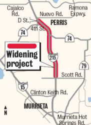
I-215 South Project - Widening I-215 between Murrieta and Perris (~ RIV R9.511 to RIV R15.484)
There are a number of projects in the works for the I-215 corridor between Murrieta and Moreno Valley. Construction isn't expected to begin until 2010 at the earliest. The first phase would add lanes in the median and the remaining phase, not expected until 2015, would widen the freeway to its ultimate width, which is yet to be decided. According to the LA Times Bottleneck blog in September 2007, the CTC approved $13 million to widen I-215 from the I-15/I-215 interchange north to Nuevo Road in Perris. The allocation was part of a larger $674 million funding announcement for 35 transportation-related projects statewide. Funding sources include $225 million from Proposition 1B, $60 million from Proposition 42 and $389 million from the Public Transportation Account. (CNS). As of December 2007, there were community public meetings in Perris on this widening. It was noted that Caltrans has started the preliminary engineering and environmental planning process, and that the entire $417M, three-part project would widen about 29.25 miles on I-215 between I-15 and Route 60. The central portion of the project is expected to save about 4,600 hours of vehicle delays and 2,000 gallons of gasoline per day, according to Caltrans and the RCTC. Construction for this portion is expected to begin in 2012.
In 2007, the CTC recommended that the Corridor Improvement Mobility Account fund widening from I-15 to Scott Road ($38,579K recommended out of a request of $62.231K). It did not recommend funding for a mixed flow lane between Scott Rd. and Nuevo Rd ($172,730K) or HOV lanes between Nuevo Rd. and Box Springs Rd. ($181,700K).
In December 2008, the CTC approved funding to construct a third mixed flow lane in each direction and widen Route 215 to a minimum of three lanes in each direction near the city of Murrieta. The project is programmed in the Corridor Mobility Improvement Account Program and Regional Improvement Program. The estimated cost of the project is $62,321,000 and is estimated to begin construction in Fiscal Year 2010-11. The scope, as described for the preferred alternative, is consistent with the project scope set forth in the approved project baseline agreement. The project runs from Murrieta Hot Springs Road to Scott Road.
 In August 2009, it was reported that the Riverside County Transportation Commission is working on plans
for how to widen I-215 from Perris almost to Murrieta. They have engaged
engineering firm URS to finalize engineering and design of the project,
from Scott Road north of Murrieta to Nuevo Road, north of Perris. The
13-mile stretch is the middle of three adjacent projects along I-215 to
widen the freeway from I-15 in Temecula to Route 60 near Moreno Valley. If
approved by RCTC, URS will be paid up to $14.5 million for the design and
engineering work. URS did similar design work on the southern segment of
the I-215 widening project. The middle phase of widening I-215 to three
lanes and adding a carpool lane from Nuevo Road north to Route 60 is the
most complex of the three when it comes to design. Bridges at D Street and
Perris Boulevard in Perris must be lengthened to accommodate the larger
freeway. The entire widening project is expected to cost $417 million,
including $38.6 million for the southern segment from California's Prop.
1B transportation bond voters approved in 2006. Work on the southern
section of the widening is set to start in 2011, followed a year later by
the central section. Construction north of Perris to Riverside is not
anticipated until 2012, with all phases finished by 2015.
In August 2009, it was reported that the Riverside County Transportation Commission is working on plans
for how to widen I-215 from Perris almost to Murrieta. They have engaged
engineering firm URS to finalize engineering and design of the project,
from Scott Road north of Murrieta to Nuevo Road, north of Perris. The
13-mile stretch is the middle of three adjacent projects along I-215 to
widen the freeway from I-15 in Temecula to Route 60 near Moreno Valley. If
approved by RCTC, URS will be paid up to $14.5 million for the design and
engineering work. URS did similar design work on the southern segment of
the I-215 widening project. The middle phase of widening I-215 to three
lanes and adding a carpool lane from Nuevo Road north to Route 60 is the
most complex of the three when it comes to design. Bridges at D Street and
Perris Boulevard in Perris must be lengthened to accommodate the larger
freeway. The entire widening project is expected to cost $417 million,
including $38.6 million for the southern segment from California's Prop.
1B transportation bond voters approved in 2006. Work on the southern
section of the widening is set to start in 2011, followed a year later by
the central section. Construction north of Perris to Riverside is not
anticipated until 2012, with all phases finished by 2015.
[Based on an article in the Riverside Press Enterprise,
"Widening of 13-mile stretch of I-215 gets OK for final design,
engineering", 2009-08-24]
In January 2012, it was reported that the widening project on the six-mile stretch between Murrieta Hot Springs and Scott roads (the "South Project") should be completed in August 2012. Ground-breaking was in February 2011. The project will add a lane in each direction between the two exits. The $33-million project—also known as the I-215 South Project—has created about 594 jobs.
The SAFETEA-LU act, enacted in August 2005 as the reauthorization of TEA-21, provided the following expenditures on or near this route:
Clinton Keith Road Interchange (~ RIV R11.792)
In April 2009, it was noted that widening the Clinton Keith Road bridge at I-215 in Murrieta will be done with 2009 Federal Stimulus funding. The project calls for the widening of the two-lane bridge to six lanes. It will take 18 months to complete. Murrieta has pursued the project to relieve traffic at the crossing caused mainly by vehicles from a nearby high school and shopping center. Originally, the city was relying on Measure A funds for the final $10 million for the project. Shortly after Obama proposed the stimulus, however, Riverside County listed the project as a top stimulus priority because of its regional importance and its "shovel ready" status.
In September 2014, it was reported that Murrieta
officials are working to fast-track a new I-215 interchange at Keller Road
in the northern reach of the city. Specifically, the city wants to build
an interchange at Keller, midway between Scott and Clinton Keith roads, to
serve a proposed Kaiser Permanente campus and the existing Loma Linda
University Medical Center – Murrieta. The exit would provide access
to anticipated offices along the east side of I-215 and a planned
subdivision of 750 houses known as Murrieta Hills to the west. The city
signed $1.25 million contract with Pasadena-based Jacobs Engineering Inc.
with a goal of completing a condensed second phase of preparation in about
18 months. The phase – which involves planning, design and
environmental study – usually takes three to five years. The opening
could come as early as 2020. The door to a Keller interchange when
Caltrans reclassified I-215 as an urban freeway from its previous rural
label. Rules for rural highways limit exits to one every two miles, while
urban freeways can space them a mile apart. Keller is a mile south of
Scott. What’s envisioned at Keller is a hybrid of the diamond and
cloverleaf interchange models. On three sides there would be a diamond
design with a ramp branching off or onto the freeway in a straight line.
On the remaining side, there would be a circular onramp connecting
eastbound Keller Road with northbound I-215.
(Source: Press-Enterprise, 9/17/2014)
In December 2016, it was reported that the CTC approved
a project on I-215 in Murrieta, 2 miles north of Clinton Keith Road to 1
mile south of Scott Road (with city lead) to build a double roundabout
interchange. The cost will be $32,406,000 beginning summer 2021 with
completion in spring 2023.
(Source: Valley News, 12/2/2016)
In December 2016, it was reported that the CTC
approved a project on I-215 in Menifee near Murrieta at Scott Road (~ RIV
R15.507) to reconstruct the interchange. The cost will be $63,781,000
starting in spring 2017 with completion in fall 2018. In also approved a
project in Menifee at McCall Boulevard interchange with interchange
modifications. The cost will be $27,510,000 starting summer 2012 with
completion summer 2023. Lastly, it also approved a third project in
Menifee to construct a four-lane bridge overcrossing. The cost will be $
4,000,000 starting summer 2017 with completion summer 2018.
(Source: Valley News, 12/2/2016)
I-215 Central Project - Widening between Scott Road and Nuevo Road (~ RIV R15.484 to RIV R27.846)
In October 2011, the CTC approved for future consideration of funding a project ("I-215 Central Project") that will construct one mixed flow lane in each direction from Scott Road to the Nuevo Road interchange, and reconstruct auxiliary lanes between the D Street interchange and the Nuevo Road interchange. The project is fully funded. The project is programmed in the 2010 State Transportation Improvement Program and includes local funds. The total estimated cost is $190,947,000 for capital and support. Construction is estimated to begin in Fiscal Year 2012-13. The scope as described for the preferred alternative is consistent with the project scope programmed by the Commission in the 2010 State Transportation Improvement Program. A copy of the MND has been provided to Commission staff. The project will mitigate potential impacts to biological resources to a less than significant level. Potential impacts to wetlands in the project area will be mitigated by purchasing mitigation bank credits and participation in an In Lieu Fee program. As a result, an MND was completed for this project.
Design work is expected to wrap up on the I-215 Central Project in late 2012, according to RCTC. The estimated project cost is $143 million and is forecast to provide 2,160 jobs. Contingent on funding, construction on the Central Project may start in late 2012 and is estimated to take about three years.
In January 2012, it was reported that construction should be completed on the new 4th Street/Redlands Ave. bridge in Perris by February 2012. The $30 million project replaces the old two-lane bridge that connected 4th Street/Route 74 to the west and Redlands Avenue to the east of the freeway. Work began on the bridge and expanded entrance and exit ramps in July 2010, and two lanes of the new bridge opened in October when crews demolished the outdated overpass.
In May 2012, the CTC approved $113.4 to million fund most of the $120 million effort to widen I-215 to three lanes in each direction between Scott Road and Nuevo Road. Work on the 12.5-mile stretch will start in late 2012, after the "South Project" is finished.
In October 2015, it was reported that the I-215 Central
Project had officially opened. The ribbon-cutting ceremony was held at
Templo del Evangelio church, in the shadow of the Perris Boulevard bridge.
The Central project is the second phase of the more than $400 million,
three-phase freeway widening project that began in 2011. The overall
project will widen I-215 from near its split with I-15 in Temecula to
Route 60 in Moreno Valley. It will eventually convert what was once a
sparsely traveled road with traffic signals into a three-lane thoroughfare
from Murrieta to Riverside. The $123 million Central, or second, phase
began in 2013 turned 12 miles of I-215 into a three-lane thoroughfare in
both directions from Scott Road along the Menifee-Murrieta border to Nuevo
Road in Perris. The lanes were opened in October 2015. The Southern, or
first, phase began in 2011 and added a third lane from Murrieta Hot
Springs Road in Murrieta to Scott Road. The $29 million leg opened to
traffic in September 2012. It’s unknown when work will start on the
northernmost part of the project, which would add a carpool lane in each
direction from Perris to Moreno Valley and widen Route 60. The Central
phase took 33 months to complete. The project required about 235,000 tons
of asphalt and concrete, and nearly 2,000 tons of reinforced steel. Though
the expansion is nearly completed, motorists still will see plenty of
construction along the roadway thanks to other ongoing projects. A new
interchange is being built a few miles to the south at Newport Road while
the freeway bridge is expanded.
(Source: Press Enterprise, 10/30/2015)
Newport Road Crossing - Menifee (~ RIV R18.536)
In March 2013, the CTC approved for future consideration of funding a project that will widen the Newport Road overcrossing and reconstruct the I-215/Newport Road interchange ramps in the city of Menifee. The project is fully funded with local dollars. The total estimated cost is $47,700,000 for capital and support. Construction is estimated to begin in Fiscal Year 2013-14.
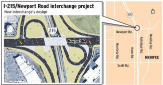 In March 2015, it was reported that construction was about to start on the
I-215/Newport Road intersection. About $10 million has been spent on
environmental approval, design and right-of-way clearance on the $43
million project. Groundbreaking on construction is April 8, 2015. In
addition to creating two cloverleafs, which would ensure all the traffic
accessed the freeway with right-hand turns, part of the freeway bridge
will be expanded, while another portion will be torn down and rebuilt. In
addition to constructing the cloverleafs, acceleration lanes will be added
to the northbound and southbound on-ramps and a deceleration lane to the
northbound off-ramp. The expanded and rebuilt bridge will have six lanes
of through traffic with deceleration lanes to help the flow of on-ramp
traffic. Newport has become a major east-west arterial road. Over the last
decade, connections with Domenigoni Parkway to the east and Railroad
Canyon Road to the west have been completed, creating a commuter corridor
between Hemet and Lake Elsinore. Current projected completion for the
project is winter 2016-17.
In March 2015, it was reported that construction was about to start on the
I-215/Newport Road intersection. About $10 million has been spent on
environmental approval, design and right-of-way clearance on the $43
million project. Groundbreaking on construction is April 8, 2015. In
addition to creating two cloverleafs, which would ensure all the traffic
accessed the freeway with right-hand turns, part of the freeway bridge
will be expanded, while another portion will be torn down and rebuilt. In
addition to constructing the cloverleafs, acceleration lanes will be added
to the northbound and southbound on-ramps and a deceleration lane to the
northbound off-ramp. The expanded and rebuilt bridge will have six lanes
of through traffic with deceleration lanes to help the flow of on-ramp
traffic. Newport has become a major east-west arterial road. Over the last
decade, connections with Domenigoni Parkway to the east and Railroad
Canyon Road to the west have been completed, creating a commuter corridor
between Hemet and Lake Elsinore. Current projected completion for the
project is winter 2016-17.
(Source: Press-Enterprise, 3/30/2015)
The SAFETEA-LU act, enacted in August 2005 as the reauthorization of TEA-21, provided the following expenditures on or near this route:
In October 2016, the CTC authorized relinqishment of right of way in the city of Perris on Route 74 between Seventh Street and Redlands Avenue, under terms and conditions as stated in the relinquishment cooperative agreement dated July 9, 2009, determined to be in the best interest of the State. Authorized by Chapter 635, Statutes of 2008, which amended Section 374 of the Streets and Highways Code. Also relinquishes right of way along Route 215 between 4th Street and San Jacinto Avenue (~ RIV 26.32 to RIV 26.49), consisting of collateral facilities. The City, by freeway agreement dated November 13, 1995 agreed to accept title upon relinquishment by the State. The 90-day notice period expired September 7, 2016.
In September 2006, the CTC considered relinquishment of right of way in the County of Riverside, on the west side of Route 215, between Nuevo Road and Oleander Avenue. (8-Riv-215-PM 27.9/32.4)
Mid-County Parkway Project (Currently off SHS, Between I-215 and Route 79) (~ RIV R29.4/R30.916)
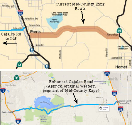 Riverside County has a project in the works to construct
a 16 mile west-east transportation corridor between I-215 and Route 79
connecting the Cities of San Jacinto and Perris. The project will consist
of a divided highway including three lanes in each direction with on and
off ramps as well as freeway-freeway type interchanges at I-215 and Route 79. This project is currently at the EIR stage.
Riverside County has a project in the works to construct
a 16 mile west-east transportation corridor between I-215 and Route 79
connecting the Cities of San Jacinto and Perris. The project will consist
of a divided highway including three lanes in each direction with on and
off ramps as well as freeway-freeway type interchanges at I-215 and Route 79. This project is currently at the EIR stage.
Note: As it appears that the Mid-County Parkway will eventually be a realignment of Route 74, more details may be found under Route 74
In May 2015, it was reported that environmental groups
have gone to court over the Mid County Parkway, saying the proposed $1.7
billion, 16-mile, six-lane freeway freeway would cut through low-income
neighborhoods, threaten wildlife areas and worsen air pollution.The
commission approved the environmental impact report for the project.
However, the suit alleges that the project is based on faulty premises
that may not come true. For example, it claims that the report uses
inflated traffic predictions for 25 years from now, when officials assume
the now-rural San Jacinto Valley will be fully developed. They argue that
widening the Ramona Expressway would be a cheaper and less environmentally
destructive alternative.
(Source: Press-Enterprise, 5/15/2015)
In
November 2015, it was reported that Riverside County was starting to
worry about the completion of the parkway. Originally (circa 2005), it
was planned as a 32-mile freeway linking the San Jacinto Valley to I-15
as a way to improve east-west traffic flow. As of 2015, the Mid-County
Parkway has been cut in half and won’t reach I-15, if it’s
built at all. And Riverside city officials worry about the future of
efforts to ease congestion that snarls Route 91 and clogs city streets.
The Riverside City Council has formally shared its concerns about
proposed changes to the county’s general plan, which reflect the
county Transportation Commission’s 2009 decision to scale back the
parkway. The update also includes the county’s desire to improve
Cajalco and Ethanac Roads south of Riverside so they can handle more
east/west traffic and take pressure off roads running through Riverside
and Perris. The changes acknowledge the need to build links between I-15
on the county’s western edge and I-215, which runs from Riverside
to Murrieta. Riverside officials worry that without a viable
alternative, congestion on I-215 will send drivers onto already busy
Alessandro and Van Buren boulevards to get to Route 91, the
county’s main link to Orange County. In particular, the council
formally asked the county to keep in its general plan a road corridor
that served as a precursor to the Mid-County Parkway.The Mid-County
Parkway, which dates back to at least the mid-2000s, was supposed to
stretch from Route 79 in San Jacinto to I-15. But mounting opposition
from environmentalists, as well as a projected $3 billion price tag,
convinced the transportation commission to scrap the segment running
west of I-215 to I-15. Today, plans call for a 16-mile parkway with a
projected cost of $1.7 billion. The commission approved the
parkway’s environmental impact report in April 2015, but the
project faces a court challenge from environmental groups. In lieu of a
longer parkway, the commission, a panel of elected officials which
serves as the county’s transportation-planning body, put its faith
in a county plan to improve a 16-mile stretch of Cajalco Road from
Perris to Corona. Those improvements, which would widen the road from
two to four lanes between I-15 and I-215, are in the planning stages.
(Source: Press Enterprise, 11/8/2015)
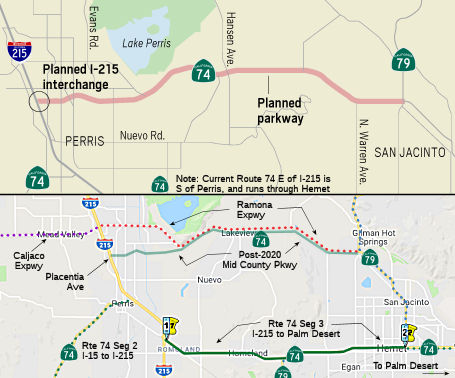 In October 2018, it was reported that $65 million in funding (including $7.1MM in SB1
funds) was finally in place for the first interchange of the Mid-County
Parkway (potential future realignment of Route 74). As planned, it will
start at an interchange on I-215 at Placentia Avenue and stretch eastward,
eventually taking over the thoroughfare currently traversed by the Ramona
Expressway. The plan is to add an entrance and exit to I-215, improve a
frontage road, widen the existing Placentia Avenue bridge and widen
Placentia between Harvill and Indian avenues, a news release states. It
will provide an alternative to Route 60 to the north and Route 74 to the
south. As of October 2018, however, only a small portion of the
approximately $1 billion project is funded: the interchange on I-215 near
Placentia Avenue. When completed, the freeway will be a designated state
route with three lanes in either direction. A handful of homes north of
Paragon Park in Perris will have to be demolished to make way for the new
freeway. But that's several years away and that part of the project isn't
even funded yet. The interchange is scheduled to begin construction in
2020. The remainder of the freeway will begin construction afterward,
depending on the availability of funding. The Parkway came out of the
Riverside County Integrated Project, a three-pronged planning effort
launched around the turn of the century to identify new highway corridors,
design a habitat preservation plan and update the county’s blueprint
for growth. Originally, the freeway was to run 32 miles from I-15 in
Corona to Route 79 in San Jacinto. In 2009, the county transportation
commission scrapped the western half between I-15 and I-215 amid
escalating costs and concerns about environmental constraints in the Lake
Mathews area and Gavilan Hills. The original concept was to run it down
Route 74, but the Perris City Council fiercely opposed that route because
downtown Perris was in the path. For the western section, the county plans
to widen Cajalco Road to four lanes between I-15 and I-215.
In October 2018, it was reported that $65 million in funding (including $7.1MM in SB1
funds) was finally in place for the first interchange of the Mid-County
Parkway (potential future realignment of Route 74). As planned, it will
start at an interchange on I-215 at Placentia Avenue and stretch eastward,
eventually taking over the thoroughfare currently traversed by the Ramona
Expressway. The plan is to add an entrance and exit to I-215, improve a
frontage road, widen the existing Placentia Avenue bridge and widen
Placentia between Harvill and Indian avenues, a news release states. It
will provide an alternative to Route 60 to the north and Route 74 to the
south. As of October 2018, however, only a small portion of the
approximately $1 billion project is funded: the interchange on I-215 near
Placentia Avenue. When completed, the freeway will be a designated state
route with three lanes in either direction. A handful of homes north of
Paragon Park in Perris will have to be demolished to make way for the new
freeway. But that's several years away and that part of the project isn't
even funded yet. The interchange is scheduled to begin construction in
2020. The remainder of the freeway will begin construction afterward,
depending on the availability of funding. The Parkway came out of the
Riverside County Integrated Project, a three-pronged planning effort
launched around the turn of the century to identify new highway corridors,
design a habitat preservation plan and update the county’s blueprint
for growth. Originally, the freeway was to run 32 miles from I-15 in
Corona to Route 79 in San Jacinto. In 2009, the county transportation
commission scrapped the western half between I-15 and I-215 amid
escalating costs and concerns about environmental constraints in the Lake
Mathews area and Gavilan Hills. The original concept was to run it down
Route 74, but the Perris City Council fiercely opposed that route because
downtown Perris was in the path. For the western section, the county plans
to widen Cajalco Road to four lanes between I-15 and I-215.
(Source: ABC7, 10/24/2018; Press-Enterprise, 10/24/2018)
In June 2019, the CTC approved for future consideration
of funding the Midway Parkway Project. The Project will construct a
16-mile west/east transportation corridor known as the Midway Parkway
between I-215 and Route 79, including full or partial access control with
grade separations at local intersections, a mix-flow lane to the Van Buren
Boulevard interchange, an additional mix-flow lane from Nuevo Road to the
Cajalco-Ramona Expressway, a new interchange at Placentia Avenue, and
modifications to the existing interchange at the Cajalco Road/Ramona
Expressway. The Project is located in western Riverside County between
I-215 in the west and Route 79 in the east, Riverside County. On April 8,
2015, the Riverside County Transportation Commission adopted the Final
Environmental Impact Report, including the Statement of Overriding
Considerations. The Project is estimated to cost $1,321,042,000 and is
fully funded with Local Measure A Funds ($263,700,000), Riverside County
Bond Funds ($932,000,000), Riverside County Transportation Uniform
Mitigation Fee Funds ($118,300,000), and Local Partnership Program Funds
($7,042,000). Construction is estimated to begin in Fiscal Year 2019-20.
(Source: June 2019 CTC Minutes, Agenda Item
2.2c.(9))
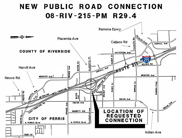 In December 2019, the CTC had on its agenda authorization of a new public road
connection to I-215 at Placentia Avenue, PM R29.4. The I-215/Placentia
Avenue interchange was originally proposed in the planning stages of the
I-215 corridor in the late 1980s, and right-of-way was purchased for a
future interchange when operational needs and local development justified
its construction. A grade-separated overcrossing was constructed at
Placentia Avenue as part of the original I-215 corridor project. The
interchange was also contemplated as part of RCTC's Mid County Parkway
(MCP) project, which began development in 2005. The Project Study Report
for the MCP between I-15 in the city of Corona and Route 79 near San
Jacinto was approved on December 29, 2004. In May 2008, the FHWA sent a
letter to Caltrans stating the acceptability with conditional approval of
the original New Connection Report. On February 20, 2013, the public was
informed of the decision to reduce the length of the corridor to focus
improvements where the need was the greatest, between I-215 and Route 79.
FHWA provided the final approval of the New Connection Report for the
change in Interstate access on December 16, 2016. The purpose of the
proposed project is to improve local access to I-21 by adding an
interchange at Placentia Avenue in the City of Perris to serve the growing
cities of Perris, Hemet, San Jacinto, and the adjacenet unincorporated
areas of Riverside County. The proposed improvements include: (1)
construction of a new interchange at Placentia Avenue and I-215 with NB
and SB entrance and exit ramps on the east and west sides of I-215 at
Placentia Avenue; (2) relocation of the East Frontage Road; (3) widening
of the Placentia Avenue bridge from two to six lanes between Harvill
Avenue on the west and Indian Avenue on the east; (4) construction of
drainage improvements; and (5) installation of new traffic signals on
Placentia Ave at Harville Avenue, Indian Avenue, East Frontage Road, and
at the ramp intersections. The current construction funding for the
project is $46,475K, including $6,000K for construction management.
Riverside County Measure A is funding $39,433K, and the SB1 LPP is funding
$7,042K. The funding for the right of way acquisition is $25,900K from
Measure A. The General Plan for the City of Perris includes a future local
service interchange at Placentia Avenue. RCTC has agreed to include the
addition of local access at Placentia Ave as part of the MCP project.
Riverside County is also in favor of the interchange at I-215 and
Placentia Avenue.
In December 2019, the CTC had on its agenda authorization of a new public road
connection to I-215 at Placentia Avenue, PM R29.4. The I-215/Placentia
Avenue interchange was originally proposed in the planning stages of the
I-215 corridor in the late 1980s, and right-of-way was purchased for a
future interchange when operational needs and local development justified
its construction. A grade-separated overcrossing was constructed at
Placentia Avenue as part of the original I-215 corridor project. The
interchange was also contemplated as part of RCTC's Mid County Parkway
(MCP) project, which began development in 2005. The Project Study Report
for the MCP between I-15 in the city of Corona and Route 79 near San
Jacinto was approved on December 29, 2004. In May 2008, the FHWA sent a
letter to Caltrans stating the acceptability with conditional approval of
the original New Connection Report. On February 20, 2013, the public was
informed of the decision to reduce the length of the corridor to focus
improvements where the need was the greatest, between I-215 and Route 79.
FHWA provided the final approval of the New Connection Report for the
change in Interstate access on December 16, 2016. The purpose of the
proposed project is to improve local access to I-21 by adding an
interchange at Placentia Avenue in the City of Perris to serve the growing
cities of Perris, Hemet, San Jacinto, and the adjacenet unincorporated
areas of Riverside County. The proposed improvements include: (1)
construction of a new interchange at Placentia Avenue and I-215 with NB
and SB entrance and exit ramps on the east and west sides of I-215 at
Placentia Avenue; (2) relocation of the East Frontage Road; (3) widening
of the Placentia Avenue bridge from two to six lanes between Harvill
Avenue on the west and Indian Avenue on the east; (4) construction of
drainage improvements; and (5) installation of new traffic signals on
Placentia Ave at Harville Avenue, Indian Avenue, East Frontage Road, and
at the ramp intersections. The current construction funding for the
project is $46,475K, including $6,000K for construction management.
Riverside County Measure A is funding $39,433K, and the SB1 LPP is funding
$7,042K. The funding for the right of way acquisition is $25,900K from
Measure A. The General Plan for the City of Perris includes a future local
service interchange at Placentia Avenue. RCTC has agreed to include the
addition of local access at Placentia Ave as part of the MCP project.
Riverside County is also in favor of the interchange at I-215 and
Placentia Avenue.
(Source: December 2019 CTC Agenda, Agenda Item
2.3b)
In March 2020, the CTC approved
the following financial allocation: 08-Riv-215 R27.9/R32.8.
I-215/Placentia Avenue Interchange Project. In the city of Perris, from
0.3 Miles South of Perris Boulevard Undercrossing to 0.5 Miles North of
Oleander Avenue Overcrossing. Construct a new interchange at Placentia
Avenue. Construct various improvements at existing intersections.
Financial allocation: $7,090,000.
(Source: March 2020 CTC Agenda, Agenda Item
2.5s.(2) #2)
In June 2020, the CTC approved amending the Local
Partnership Formulaic Program – Advance Program of Projects to
program $14,160,000 for Riverside County Transportation Commission to fund
construction of the I-215/Placentia Avenue Interchange project in Fiscal
Year 2020-21. The project will construct a new interchange. The project
will improve connectivity and reduce greenhouse gas emissions.
(Source: June 2020 CTC Agenda, Agenda Item 4.23)
In October 2022, it was reported that the interchange
should open sometime in Fall 2022.
(Source: RCTC on FB, 10/3/2022)
Van Buren Bridge (~ RIV R34.136)
In December 2009, the CTC approved for future consideration of funding a project that will reconstruct improvements at the I-215/Van Buren Boulevard Interchange. The proposed improvements include widening of the Van Buren Boulevard Bridge, addition of an eastbound to northbound entrance ramp, reconfiguration and widening of the existing entrance and exit ramps, and construction of auxiliary lanes from Van Buren Boulevard to Cactus Avenue. The project is programmed in the Trade Corridors Improvement Fund (TCIF) and includes local funds. Total estimated cost is $97,550,000, capital and support. Construction is estimated to begin in Fiscal Year 2011-12. The scope as described for the preferred alternative is consistent with the project scope set forth in the approved project baseline agreement.
In October 2011, it was reported that, due to the favorable sale of bonds, state funding was available for the Van Buren bridge as well as a bridge over Iowa Avenue in Riverside. Both projects have long been identified as critical road improvements that will create construction jobs and help move freight through the Inland area. The planned, $52 million Van Buren overpass will widen the bridge so trucks serving warehouses near the freeway will have better access. Iowa Avenue is one of a dozen railroad grade separations in the county designed to eliminate long waits by cars and trucks as freight trains move through the region.
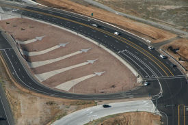 In November 2015, it was reported that the reconstructed Van Buren interchange won an award
from American Planning Association. California Chapter. The interchange is next to the March Air Field Museum and March ARB, and honors both of those organizations. In a design best seen from the air (naturally), five aircraft are seen in silhouette. The
interchange was constructed by Falcon CA. Complete cost, according to Falcon, was $56.7M. Improvements include reconfiguring of the interchange ramp, realignment of
I-215, replacement of two existing bridges and local street improvements.
The new overcrossing bridge is a two span continuous 7.25′ deep
cast-in-place prestressed concrete box girder bridge approximately
318.70′ in length and 98.42′ in width. New overhead bridge is
a single span x 20 ea. precast/ prestressed girders 141.96′ long and
width varying from 154.98′ to 151.38′. Work also included the
construction of northbound loop on-ramp, realignment of northbound on/off
ramps and widening/realignment of southbound on/off ramps, and widening
freeway in both directions to accommodate the new ramps, construction of
roadway approaches on Van Buren Blvd in both directions, as well as
construction of storm drainage improvements, utility relocations,
streetlight, signals, irrigation, and landscaping.
In November 2015, it was reported that the reconstructed Van Buren interchange won an award
from American Planning Association. California Chapter. The interchange is next to the March Air Field Museum and March ARB, and honors both of those organizations. In a design best seen from the air (naturally), five aircraft are seen in silhouette. The
interchange was constructed by Falcon CA. Complete cost, according to Falcon, was $56.7M. Improvements include reconfiguring of the interchange ramp, realignment of
I-215, replacement of two existing bridges and local street improvements.
The new overcrossing bridge is a two span continuous 7.25′ deep
cast-in-place prestressed concrete box girder bridge approximately
318.70′ in length and 98.42′ in width. New overhead bridge is
a single span x 20 ea. precast/ prestressed girders 141.96′ long and
width varying from 154.98′ to 151.38′. Work also included the
construction of northbound loop on-ramp, realignment of northbound on/off
ramps and widening/realignment of southbound on/off ramps, and widening
freeway in both directions to accommodate the new ramps, construction of
roadway approaches on Van Buren Blvd in both directions, as well as
construction of storm drainage improvements, utility relocations,
streetlight, signals, irrigation, and landscaping.
(Source: CA Streets Blog, 11/23/2015; Falcon Engr.)
Alessandro to Eucalyptus Auxiliary Lanes (08-RIV-215 R36.6/R37.2)
") In June 2019, the CTC approved the following SHOPP
amendment: 08-Riv-215 R36.6/R37.2 PPNO 3013W ProjID 0819000045. I-215 In
the city of Riverside, from 0.2 mile north of Alessandro Boulevard to 0.2
mile south of Eucalyptus Avenue. Construct auxiliary lanes in the
northbound and southbound directions between the onramps and offramps.
PA&ED $699K; PS&E $762K; R/W Sup $22K; Con Sup $1,251K; R/W Cap
$24K; Const Cap $6,015K;Total $8,773K. BC: 5/3/2021.
In June 2019, the CTC approved the following SHOPP
amendment: 08-Riv-215 R36.6/R37.2 PPNO 3013W ProjID 0819000045. I-215 In
the city of Riverside, from 0.2 mile north of Alessandro Boulevard to 0.2
mile south of Eucalyptus Avenue. Construct auxiliary lanes in the
northbound and southbound directions between the onramps and offramps.
PA&ED $699K; PS&E $762K; R/W Sup $22K; Con Sup $1,251K; R/W Cap
$24K; Const Cap $6,015K;Total $8,773K. BC: 5/3/2021.
(Source: June 2019 CTC Minutes, Agenda Item
2.1a.(1) Item 25)
In June 2019, the CTC approved the following SHOPP
support phase allocation: $699,000 08-RIV-215 R36.6/R37.2 PPNO 3013W
ProjID 0819000045. I-215 In the city of Riverside, from 0.2 mile north of
Alessandro Boulevard to 0.2 mile south of Eucalyptus Avenue. Construct
auxiliary lanes in the northbound and southbound directions between the
onramps and offramps. PA&ED $699,000 (Concurrent amendment under SHOPP
Amendment 18H-010.)
(Source June 2019 CTC Minutes, Agenda Item
2.5b.(2a) Item 33)
The 2020 SHOPP, approved in May 2020, included the
following Collision Reduction item of interest (carried over from the 2018
SHOPP): 08-Riverside-215 PM R36.6/R37.2 PPNO 3013W Proj ID 0819000045 EA
1K460. I-215 in the city of Riverside, from 0.2 mile north of Alessandro
Boulevard to 0.2 mile south of Eucalyptus Avenue. Construct auxiliary
lanes in the northbound and southbound directions between the onramps and
offramps. Programmed in FY20-21, with construction scheduled to start in
November 2021. Total project cost is $8,773K, with $6,039K being capital
(const and right of way) and $2,734K being support (engineering,
environmental, etc.).
(Source: 2020 Approved SHOPP a/o May 2020)
In May 2020, the CTC approved the following support
allocation: 08-Riv-215 R36.6/R37.2. PPNO 3013W ProjID 0819000045 EA 1K460.
I-215 In the city of Riverside, from 0.2 mile north of Alessandro
Boulevard to 0.2 mile south of Eucalyptus Avenue. Construct
auxiliary lanes in the northbound and southbound directions between the
onramps and offramps. Allocation: PS&E $762,000; R/W Sup $22,000.
(Source: May 2020 CTC Agenda, Agenda Item 2.5b.(2)
#27)
In August 2021, the CTC was informed of the following
SHOPP Safety Resolution G-03-10 Delegated Allocation: $6,286,000.
08-Riv-215 R36.6/R37.2. PPNO 08-3013W; ProjID 0819000045; EA 1K460. I-215
Near the city of Riverside, from 0.2 mile north of Alessandro Boulevard to
0.2 mile south of Eucalyptus Avenue. Outcome/Output: Improve safety
and operations by constructing auxiliary lanes in the northbound and
southbound directions between the onramps and offramps. This project will
reduce the number and severity of collisions. (Two month time extension
for CONST and CON ENG approved under Waiver 21-59; June 2021.) Allocation
Date: 07/15/2021. Allocation division: CON ENG $1,251,000 CONST
$6,015,000.
(Source: August 2021 CTC Agenda, Agenda Item
2.5f.(3) #5)
In January 2023, the CTC approved a request for
an additional $804,000 in Construction Support for the SHOPP Safety
Improvements project on I-215, in Riverside County, to complete the
construction contract. This project is located on I-215 near the City of
Riverside, from north of Alessandro Boulevard to south of Eucalyptus
Avenue, in Riverside County (08-Riv-215 R36.6/R37.2. PPNO 08-3013W; ProjID
0819000045; EA 1K460). The project will construct auxiliary lanes in
both directions between the on- and off-ramps, upgrade drainage systems,
install signs and guardrail, construct maintenance vehicle pullouts, and
modify lighting systems. In June 2019, the project was programmed
for $1,251,000 in Construction Support in the SHOPP for allocation in
Fiscal Year 2020-21. In June 2021, the project received a 2-month
allocation time extension for the construction phase. In July 2021,
the project was allocated for $1,179,000 in Construction Support. In
February 2022, the project was awarded for $1,179,000 in Construction
Support. In June 2022, construction began with 90 working
days. In October 2022, the project received G-12 funds in the amount
of $318,000. The remaining funds are currently at $155,000 in Construction
Support. The project is 40 percent complete with 65 working days
remaining. The planned Construction Contract Acceptance is scheduled
for January 2024. The project realized cost increases due to the redesign
of the drainage plans as a result of the differing site conditions of the
topography as there was an error in the surveys. While construction was in
progress, it was determined that the field conditions did not reflect what
was in the contract plans. Following consultation with the project
engineer, it was determined that the drainage plans would require a
redesign to be in alignment with the field conditions. The drainage
systems were therefore upgraded to meet current design standards. As a
result, additional roadway drainage systems were required due to the
elimination of overside drains and some roadside drainage ditches that
would not have met the current design standards. The plans were also
revised to include the installation of edge drains and pipe inlets to
properly discharge the stormwater. This undertaking required
additional design, surveys, environmental, and construction support not
accounted for in the original workplan. The drainage redesign support work
included additional surveys, hydraulic analyses, drafting and review of
the revised plans between the various functional units in the
Department. These additional resources amount to $155,000. The
construction support work included verification of field topography,
reviewing and processing change orders, addressing project delays, working
with the functional units on the redesign of the drainage systems, and
addressing potential claims made by the contractor. After reviewing the
changes with the contractor, it was determined that additional working
days would be required to complete the revised work. These delays
resulted in the need for additional construction support and contract
administration. The project originally had 90 working days to facilitate
the construction of the original scope. With the redesign of the
drainage plans, an additional 70 working days will be required, bringing
the total to 160 working days. These additional resources amount to
$649,000.
(Source: January 2023 CTC Agenda, Agenda Item 2.5e.(10))
Moreno Valley to Riverside (Jct Route 60 to Jct Route 91)
In July 2019, it was reported that the RCTC is considering an ambitious
plan for additional HOT lanes in the county:
(Source: $$ Press Enterprise, 7/6/2019)
Route Widening - Moreno Valley to Riverside (~ RIV R38.579 to RIV R43.051)
As a side effect of the Route 91 interchange rework, a
a bottleneck was created where the freeway narrows from three lanes to one
in Moreno Valley. Caltrans intentionally created it in 2006 to protect
workers widening the Box Springs Road bridge over a railroad as part of
the Route 60/Route 91/I-215 interchange project. But when the Caltrans
deleted the bridgework from the project in 2007 to save time and money,
Caltrans did nothing to ease the traffic headache. The narrowing occurs
where westbound Route 60 funnels into one lane at the merger with
northbound I-215. As of April 2008, Caltrans had planned to make this two
lanes again, but only temporarily. The merger will be narrowed again in
late 2009 or early 2010, this time for workers to finish the same freeway
bridge, now part of a different project managed by the RCTC. The bridge
has had numerous construction problems. In February 2007, workers found
that the reinforcing steel, or rebar, they had installed for one of the
bridge's supports did not leave enough space for the planned insertion of
high-tensile steel to strengthen the bridge. Caltrans admitted they had
made a design error and instructed the contractor Washington-Obayashi to
torch-cut and remove the conflicting rebar. Caltrans paid about $56,000 to
correct the error. A few months later, Caltrans instructed workers to even
out the bumpy concrete deck of the bridge by grinding it down. But then
Caltrans and the contractor determined that doing so would thin out the
rebar in some places and damage the bridge. Caltrans and the contractor
agreed to solve the problem by paving over the deck with a special
concrete and making other repairs. Late submissions to the railroad
company and delayed change orders for the bridge would delay the project
even more. By the end of May, Caltrans announced it planned to delete the
remaining work on the bridge. The decision, made final in October, cut
almost $800,000 from the contract, and allowed construction to proceed on
other parts of the project. In order to drop the bridgework, Caltrans
estimated it will have to spend $100,000 to shore up and retrofit the
partially built bridge. Additionally, during construction, Caltrans found
that its plans for the bridge were not compatible with an upcoming
Riverside County Transportation Commission project to improve the East
Junction. In October 2007, the Riverside County Transportation Commission
added the deleted bridge widening along with other East Junction work to
an upcoming project in a vote that increased that project's budget from
$35.4 million to $55.7 million. The commission cobbled together funding
for the increase from federal, state and local sources.
(Source: Riverside PE, March 22, 2008)
CTC is in the process of considering
construction of two HOV or two mixed-flow lanes between University Avenue
and Day Street in Riverside County; and, in the same area, construction of
a truck-bypass connector, bicycle lanes, auxiliary lanes, two direct
connectors, and several interchanges; removal of ramps and interchanges;
and structure widening, overcrossing reconstruction, connectors
realignment, and ramp meter installation.
(Source: Negative EIR, May 2002, 2.2c.(2))
In April 2010, the CTC approved for future consideration of funding a project in Riverside County that would construct two HOV lanes and roadway improvements to connect the existing HOV lanes on Route 60 and Route 215 near the city of Moreno Valley. The project is fully funded in the 2008 State Transportation Improvement Program and includes federal and local funds. Total estimated project cost is $55,742,000 for capital and support. Construction is estimated to begin in Fiscal Year 2009-10. Construction activities will remove approximately two acres of willow riparian woodland. In addition, the project will require the acquisition of new right-of-way and result in several commercial displacements.
In January 2017, the CTC authorized relinquishment of right of way in the city of Riverside along Route 215 from River Crest Drive to Strong Street (08-Riv-215-PM R38.0/R43.5, essentially between Moreno Valley and just S of Highgrove), consisting of collateral facilities. The City, by freeway agreement dated October 2, 2001 agreed to accept title upon relinquishment by the State. The 90-day notice period expired November 7, 2016.
In August 2015, the CTC authorized relinquishment of right of way in the county of Riverside on Sycamore Canyon Boulevard and Central Avenue (between Riverside and Moreno Valley), consisting of realigned and reconstructed county roads and collateral facilities. (~ RIV R38.816)
In January 2007, the CTC considered relinquishment of right of way in the City of Riverside, consisting of 5 segments (a mix of Route 91 and I-215) along La Cadena Drive from Malta Place to Spruce Street and from Strong Street to Spring Garden Street, and a portion of Kansas Avenue between Roberta Street and Spruce Street, consisting of reconstructed and relocated city streets, frontage roads and cul-de-sacs. (~ RIV R42.849R)
Route 91/I-215/Route 60 Interchange (~ RIV R43.02)
There was a significant multiyear project to reconstruct the Route 91/I-215/Route 60 interchange completed in late 2008. Details may be found here. The project included rebuilding the Spruce Street bridge; relocating the existing eastbound on-ramp to Route 60 from Orange Street to Main Street; and widening the existing highway undercrossing bridges at University Avenue, Mission Inn Avenue and Third Street. The existing southbound (to I-215) loop ramp was replaced with a direct freeway-to-freeway connector, and the the northbound to westbound (to Route 91) loop ramp was replaced with a direct freeway-to-freeway connector. There the existing I-215 southbound off-ramp and northbound on-ramp at Spruce Street were removed and relocated to Route 91 as an eastbound off-ramp and a westbound on-ramp at the new Spruce Street overcrossing bridge. The project realigned East La Cadena Drive between 1st and Spruce Street, and provided a grade separation at the railroad crossing, as well as realigning West La Cadena Drive to accommodate the new interchange connectors. The Route 91 main line was widened, and auxiliary lanes added between University and the 60/91/215 interchange. Additionally, I-215 (Route 60) was widened from the 60/91/215 interchange to the 60/215 junction, including extending the existing carpool lanes from University Avenue to the 60/215 junction, and providing auxiliary lanes leading to and departing from the new freeway connectors. The existing I-215 (Route 60) Blaine Street, Iowa Avenue and Linden Street overcrossing bridges were reconstructed to span the new freeway widening, and the existing I-215 (Route 60) Blaine Street, University Avenue and Central Avenue/Watkins Drive interchanges were improved, including ramp widening. Sycamore Canyon Boulevard was realigned at Central Avenue. The project constructed a new interchange at Martin Luther King Boulevard, and removed the existing El Cerrito Drive interchange. The existing railroad overhead bridges at Down Street and Chicago Avenue were widened. At the 60/215 junction, a truck by-pass connector was constructed from southbound I-215 to eastbound Route 60 and southbound I-215. On Route 60, the existing Day Street interchange was modified. On I-215, the Box Springs Road interchange was rebuilt with an overcrossing bridge. Lastly, a concrete barrier was added on northbound I-215 at the junction to westbound Route 60. This project took over three years, cost over $317-million, and concluded in mid-2008. Caltrans officials planned to open two new connector ramps by the end of 2007, including one that soars 72 feet high and measures just over a mile long.
Riverside to San Bernardino - Jct Route 60/Route 91 to Approx. Jct. I-10/Route 215
HOV Lane Project - I-215 Bi-County HOV Gap Closure project (~ RIV 21.766 to SBD 4.988)
In June 2011, the CTC approved for future consideration of funding a project that will construct one high-occupancy vehicle lane in each direction from the Route 91/Route 60/I-215 Interchange to south of the I-215/Orange Show Road Interchange. The project is programmed in the Corridor Mobility Improvement Account and 2010 State Transportation Improvement Program and includes federal and local funds. Total estimated cost $177,695,000 for capital and support. Construction is estimated to begin in Fiscal Year 2011-12. The scope as described for the preferred alternative is consistent with the project scope set forth in the proposed project baseline agreement.
In August 2011, the CTC amended Resolution CMIA-A-0809-012 to de-allocate $15,460,000 in Proposition 1B Corridor Mobility Improvement Account (CMIA) funds from the I-215 North Segment 5 – HOV and Mixed-flow Lane Addition project (PPNO 0247N) in San Bernardino County, thereby reducing the original CMIA capital allocation of $44,667,000 to $29,207,000, to reflect contract award savings.
In May 2012, the CTC approved amending the funding baseline for a project, located across the county line between San Bernardino and Riverside Counties, that will construct approximately 7.5 miles of high occupancy vehicle (HOV) lanes in each direction of the I-215. The project limits are from the Route 91/Route 60/I-215 Interchange in Riverside County to the West Orange Show Road/South Auto Drive in San Bernardino County. The project scope also includes the replacement of the Burlington Northern Santa Fe (BNSF) Overhead structure and the bridge widening over the Union Pacific Railroad (UPRR) lines. Once constructed, this project will complete approximately 70 miles of the HOV lane system on I-215 and Route 91, from San Bernardino to Artesia in Los Angeles County. The funding baseline was amended because the preliminary design for the BNSF Overhead structure had assumed a single steel girder to replace the existing structure. Because of a large skew angle and a longer span length, the type of structure was changed to a steel truss. In addition, due to the limited available space in the freeway median, it was determined that three single track bridges will be required instead of a single structure that would have accommodated all three tracks. These changes have resulted in an increase in construction capital from $134,850,000 to $139,063,000; an increase of $4,213,000, and construction support from $13,484,000 to $16,270,000; an increase of $2,786,000. Estimated project completion is now March 2018.
In June 2012, the CTC amended the CMIA baseline agreement for the I-215 Bi-County HOV Gap Closure project (PPNO 0041G) to update the project funding plan and the delivery schedule. The project, located across the county line between San Bernardino and Riverside Counties, will construct approximately 7.5 miles of high occupancy vehicle (HOV) lanes in each direction of the I-215. The project limits are from the Route 91/Route 60/I-215 Interchange in Riverside County to the West Orange Show Road/South Auto Drive in San Bernardino County. The project scope also includes the replacement of the Burlington Northern Santa Fe (BNSF) Overhead structure and the bridge widening over the Union Pacific Railroad (UPRR) lines. Once constructed, this project will complete approximately 70 miles of the HOV lane system on I-215 and Route 91, from the city of San Bernardino to Artesia in Los Angeles County. The preliminary design for the BNSF Overhead structure had assumed a single steel girder to replace the existing structure. Because of a large skew angle and a longer span length, the type of structure was changed to a steel truss. In addition, due to the limited available space in the freeway median, it was determined that three single track bridges will be required instead of a single structure that would have accommodated all three tracks. These changes have resulted in an increase in construction capital from $134,850,000 to $139,063,000; an increase of $4,213,000, and construction support from $13,484,000 to $16,270,000; an increase of $2,786,000.
In May 2015, it was reported that Caltrans was
preparing to open a carpool lane on I-215 between Riverside and San
Bernardino that will complete a missing link along a busy commuter route
that’s more than 70 miles long. After about three years of
construction, motorists soon will have access to a 7.5-mile carpool lane
between the 60/91/215 interchange in Riverside and Orange Show Road in San
Bernardino. The added lane -- which makes four in each direction -- is
expected to relieve congestion on the route, which sees about 160,000
vehicles per day, according to a project study. By 2040, the number of
vehicles per day is expected to more than double to 335,000. Traffic
officials estimate carpool lane demand to be about 97,000 vehicles by
then. As part of the project, three railroad bridges over the freeway were
widened as well. The opening occurred at the end of May 2015.
(Source: Press-Enterprise, 5/25/2015, SanBernardino
Sun, 5/27/2015)
In January 2014, it was reported that the project between I-210 and Orange Show Road was complete. The overhaul included 15 new bridges, four new lanes, two flyovers and the reconstruction of 34 ramps.
In May 2012, the CTC authorized SHOPP funding on I-215, in Riverside County, 08-Riv-215 43.9/45.3 In and near the city of Riverside, from Columbia Avenue to the San Bernardino County line; also in Colton and Grand Terrace from the county line to south of the Route 10 interchange . $12,258,000 to rehabilitate 32.7 roadway lane miles to extend pavement service life and improve ride quality. Project will grind pavement and overlay with rubberized asphalt.
Barton Road Interchange (~ SBD 1.336)
In May 2014, the CTC approved for future consideration of funding a project in San Bernardino County that will reconstruct the I-215/Barton Road Interchange in the cities of Grand Terrace and Colton. The project is programmed in the 2014 State Transportation Improvement Program. The total estimated cost is $77,337,000 for capital and support. Construction is estimated to begin in Fiscal Year 2016-17.
In June 2016, it was reported that a cut in STIP
funding has impacted projects such as the 215 Barton Interchange
reconstruction and the Mt. Vernon/Washington Street interchange
improvement project, which are being overseen by the San Bernardino
Associated Governments regional transportation authority. SanBAG is
working on an update to their 10-year delivery plan which will reflect the
impact of this funding setback, with plans for a release of that plan
update in the next fiscal year. Until then, SanBAG will continue to fund
the Barton project using other fund sources under its authority. The board
also took action to stop work on the Washington/Mt. Vernon interchange.
(Source: Mass Transit, 6/6/2016)
Washington Street Overcrossing (08-SBd-215, PM 2.4/3.0)
In August 2020, the CTC approved for future
consideration of funding a project located on I-215 in San Bernardino
County in Colton (08-SBd-215, PM 2.4/3.0) (PPNO 3002S). The Department
proposes to replace the Washington Street Overcrossing. This project is
fully funded and is currently programmed in the 2020 SHOPP for a total of
$31,343,000 which includes Construction (capital and support) and Right of
Way (capital and support). Construction is estimated to begin in 2021. The
scope, as described for the preferred alternative, is consistent with the
project scope programmed by the Commission in the 2020 SHOPP.
(Source: August 2020 CTC Agenda, Agenda Item
2.2c.(1))
Related to the above, in August 2020, the CTC approved
the following financial allocation for construction and construction
support: $24,043,000. 08-SBd-215 PM 2.4/3.0. PPNO 08-3002S. ProjID
0815000034 EA 1F730. I-215 In Colton, from 0.3 mile south to 0.3 mile
north of Washington Street Overcrossing No. 54-0530. Outcome/Output:
Replace Washington Street Bridge to restore structural integrity and
correct the non-standard vertical clearance.
(Source: August 2020 CTC Agenda, Agenda Item
2.5b.(1) #43)
In January 2022, it was reported that there would be
freeway closures related to bridge demolition work at the Washington
Street overcrossing in Colton.
(Source: Redlands Community News, 1/7/2022)
In May 2023, the CTC approved the following additional allocation:
$875,000. 08-SBd-215 2.4/3. PPNO 08-3002S; ProjID 0815000034; EA 1F730.
I-215 In Colton, from 0.3 mile south to 0.3 mile north of
Washington Street Overcrossing № 54-0530. Outcome/Output: Replace
Overcrossing. Supplemental funds are needed to Complete Construction. CEQA
- ND, 2/4/2020; Re-validation 5/28/2020. NEPA - CE, 3/14/2018;
Re-validation 5/28/2020 Future consideration of funding approved under
Resolution E-20-74; August 2020. Total revised amount $5,758,800. The
project realized cost increases due to differing site conditions and
delays related to the utility work, an issue with replacing an existing
drainage system, and additional coordination that was needed to address
delays related to the duration of the temporary construction easements.
The project is situated in the middle of a crowded business area with
various restaurants and retail stores. The work area is very
restricted for construction activities. Although this was considered
during the design phase and temporary construction easements were
acquired, their durations were not adequate for the various delays that
occurred during construction. Additional resources were needed to
keep the businesses informed, for negotiations to extend the duration of
the temporary construction easements, and communications with various
Department staff to resolve this issue. While construction was in
progress, the project encountered power and water line issues. It
was discovered that there was no power service line identified on the
plans to energize the temporary signal lights. The contract was
suspended while the Department coordinated the development of a service
plan for the contractor. There was a delay to the schedule of the
bridge demolition work due to the late completion of a temporary water
line installation by the City. Another source of delay and related
cost increase was due an unsuitable lane closure window for the
installation of the permanent water line by the City. This work required
revised traffic handling plans and additional traffic control measures to
incorporate a full freeway closure to perform the utility work.
These additional resources amount to $610,000. The project included
demolishing a drainage inlet which conveys the discharge from a nearby
parking area for adjacent businesses. The replacement drainage
system could not be completed until the next stage of work. In the absence
of the drainage system, the parking area flooded during every rain event
which resulted in additional fieldwork and coordination of public
outreach. Additional efforts were needed to pump the water into tanks,
clean-up the debris, and respond to complaints. These additional resources
amount to $265,000.
(Source: May 2023 CTC Agenda, Agenda Item 2.5e.(6))
In August 2018, the CTC authorized relinquishment of of way in the city
of Colton (City) along Route 215 at Washington Avenue (08-SBd-215 2.775),
consisting of collateral facilities. The City, by resolution adopted May
15, 2018, agreed to waive the 90-day notice requirement and accept title
upon relinquishment by the State.
(Source: August 2018 CTC Agenda Item 2.3c.)
I-215 North Corridor Project - Colton to Route 210 (~ SBD 4.992 to SBD 9.044)
![[San Bernardino]](maps/215-sanbag.jpg) The I-215 Segments 1 and 2
project, which is part of the overall I-215 North Corridor project,
extends from south of Rialto Avenue to south of Massachusetts Avenue. The
project will construct a combination of high occupancy vehicle, mixed-flow
and auxiliary lanes. The total cost for this project is approximately $424
million. SANBAG and the Department have been working collaboratively on
the I-215 Segments 1 and 2 project, as well as the entire corridor. The
Department is performing all the right of way work, including acquisition
and utility relocation, while SANBAG is the lead on the remaining design
and construction phases. In 2007, the CTC authorized using the Corridor
Mobility Improvement Account (CMIA) to fund segments 1 and 2 ($49,120K,
total cost $430,341K) and segment 5 ($59,000K, total construction costs
$64,875K) of construction of HOV and mixed lanes between I-10 and I-210.
They also approved $22 million to fund the I-210/I-215 connectors. This
was also on the January 2007 CTC agenda. In June 2008, the CTC approved
amending the project plan to implement a corrective action plan to fully
fund the right of way (R/W) components of the project.
The I-215 Segments 1 and 2
project, which is part of the overall I-215 North Corridor project,
extends from south of Rialto Avenue to south of Massachusetts Avenue. The
project will construct a combination of high occupancy vehicle, mixed-flow
and auxiliary lanes. The total cost for this project is approximately $424
million. SANBAG and the Department have been working collaboratively on
the I-215 Segments 1 and 2 project, as well as the entire corridor. The
Department is performing all the right of way work, including acquisition
and utility relocation, while SANBAG is the lead on the remaining design
and construction phases. In 2007, the CTC authorized using the Corridor
Mobility Improvement Account (CMIA) to fund segments 1 and 2 ($49,120K,
total cost $430,341K) and segment 5 ($59,000K, total construction costs
$64,875K) of construction of HOV and mixed lanes between I-10 and I-210.
They also approved $22 million to fund the I-210/I-215 connectors. This
was also on the January 2007 CTC agenda. In June 2008, the CTC approved
amending the project plan to implement a corrective action plan to fully
fund the right of way (R/W) components of the project.
In April 2009, the CTC approved funding this project (as a loan against future bonds) from 2009 Stimulus funds.
In January 2013, it was reported that some phases of
this project were nearly complete. On 1/10/2013, northbound traffic was
diverted from the older, center lanes to the newly constructed outside
lanes between 2nd and 5th streets. The shift permitted construction crews
to complete the reconstruction of the 2nd and 3rd street overpasses. Three
lanes of traffic will be available to motorists although the final project
will include four general use lanes plus a car pool lane. By March 2013,
the agency also plans to open the 5th Street off ramps, providing another
route to access downtown San Bernardino. As of 2013, the project is 85
percent complete. Barring any weather or construction delays, SANBAG
expects to have it fully open by this fall 2013. The completed project
adds a general use lane and carpool lane in each direction on a 7.5 mile
stretch of the freeway from Orange Show Road to University Parkway near
Cal State San Bernardino. As of January 2013, workers still needed to
finish the section between 2nd and 5th streets, ramp construction at 3rd,
5th and Baseline Streets, reconstructing the 16th Street bridge and
finishing the connectors to Route 259.
(Source: Press-Enterprise, 1/4/13)
![[TCRP 57]](maps/215-tcrp-57.jpg) There are plans to add HOV lanes through downtown San Bernardino, from Route 10 to Route 210. This is TCRP Project
#57. This project will add two HOV lanes and two mixed flow lanes,
including operational improvements and interchange modifications, through
San Bernardino. The project is to be delivered in segments. In June 2006,
the CTC designated San Bernardino Associated Governments (SANBAG) as the
Implementing Agency, and updated the schedule due to the delay in
obtaining FHWA approval of the environmental re-evaluation for the
corridor, during which only limited right-of-way acquisition was allowed
by FHWA. The project is now scheduled to complete in FY 2012.
There are plans to add HOV lanes through downtown San Bernardino, from Route 10 to Route 210. This is TCRP Project
#57. This project will add two HOV lanes and two mixed flow lanes,
including operational improvements and interchange modifications, through
San Bernardino. The project is to be delivered in segments. In June 2006,
the CTC designated San Bernardino Associated Governments (SANBAG) as the
Implementing Agency, and updated the schedule due to the delay in
obtaining FHWA approval of the environmental re-evaluation for the
corridor, during which only limited right-of-way acquisition was allowed
by FHWA. The project is now scheduled to complete in FY 2012.
The I-215 North Segment 5 project will construct HOV lanes, construct mixed-flow lanes, and construct auxiliary lanes from south of Massachusetts Avenue to Route 210 in San Bernardino County.
In December 2016, the CTC authorized relinquishment of right of way in the city of San Bernardino along Route 215 from Auto Center Road to Massachusetts Avenue (08-SBd-215-PM 5.0/9.5), consisting of collateral facilities. The City, by freeway agreements dated January 21, 2003 and January 7, 2002, agreed to accept title upon relinquishment by the State. The 90-day notice period expired October 9, 2016.
In October 2016, the CTC authorized relinquishment of right of way in the city of San Bernardino along Route 215 from 2nd Street to 16th Street and on Route 66 (“H” Street) from 4th Street to 6th Street (08-SBd-215-PM 6.8/7.6, and 08-SBd-66-PM S23.16/S23.41), consisting of superseded highway and collateral facilities. The City, by freeway agreement dated January 21, 2003, agreed to accept title upon relinquishment by the State. The 90-day notice period expired August 29, 2016.
San Bernardino to Devore (Route 210 to Northern I-15 Jct.)
The San Bernardino Association of Governments is working to widen I-215 in California between DeVore and I-10. A $360 million design-build project that will widen the highway, add interchanges and high-occupancy-vehicle traffic lanes is expected to begin in July 2011, he said.
Route 210 Interchange (~ SBD 9.216 to SBD 10.488)
In late 2007, the final $233-million, 8-mile extension between the "Route 30" portion of Route 210 in San Bernardino and the Route 210 portion that continues West was completed. However, the I-210/Route 215 interchange will not be complete for a few more years. Construction was originally scheduled begin on the interchange in mid-to-late 2008, with completion around 2011/2012. However, in October 2008, SANBAG increased the delay by turning the project over to Caltrans, moving the date past 2013. A combination of factors, including seismic and structural concerns, are causing the delay of the interchanges that will include elevated "flyover" connectors, similar to those used at the I-215/Route 91 interchange. SANBAG officials made the connectors a separate project because of design changes to deal with seismic and liquefaction concerns at the site. The transition to Caltrans was felt to be beneficial because it would expedite permits and reviews, which had to go through Caltrans anyway. Another advantage to having Caltrans manage construction is that it has access to the State Transportation Improvement Program construction contingency funds that otherwise wouldn't be available to SANBAG. A potential $7.2 million could be made available.
Until the connectors are constructed, it will not be
possible to go directly from the EB Route 210 to SB I-215, nor will it be
possible to go from NB I-215 to WB Route 210. Other transitions that
connect Route 210 to I-215 already exist. The transition from SB I-215 to
EB Route 30 (Route 210) is already open. The connector road that will
bridge SB I-215 to the WB Route 210 will be operational once Route 210
opens. However, those connectors are not designed to handle the heavy
traffic loads (2,500 cars/hour) the final connectors can; the current
connectors can only carry 1,500 cars/hour. The delays are primarily
seismic: in late 1999 and early 2000, a geologist conducting work in the
area identified tell-tale signs of the potential for a seismic phenomenon
known as fault rupture. Fault-rupture damage can differ greatly from other
seismic activity so special planning is needed.
(Source: San Gabriel Daily Bulletin, 5/29/2007)
In February 2009, the CTC considered (it was approved in April 2009) a Corridor Mobility Improvement Account (CMIA) baseline amendment. This amended the CMIA baseline agreements for the Route 210/I-215 Connectors project (PPNO 0194Q) and the I-215 North Segment 5 – HOV and Mixed Flow Lane Addition project (PPNO 0247N) to change the implementing agency for both projects from SANBAG to Caltrans; increase design (PS&E) from $4,000,000 to $4,866,000 for the Route 210/I-215 Connectors project and from $4,541,000 to $5,065,000 for the I-215 North Segment 5 project; increase construction (capital and support) from $79,967,000 to $90,517,000 for the Route 210/I-215 Connectors project and decrease construction from $59,000,000 to $49,000,000 for construction and construction support for the I-215 North Segment 5 project; reprogram $12,733,000 San Bernardino Regional Improvement Program (RIP) from construction capital to construction support for the Route 210/I-215 Connectors project and $6,933,000 CMIA from construction capital to construction support for the I-215 North Segment 5 project; and combine both projects into a single construction contract. The Route 210/I-215 Connectors project is located in San Bernardino County, and will:
In December 2011, Caltrans opened the connector ramp between northbound I-215 and westbound Route 210, 15 months ahead of projections.
University Parkway Interchange (08-SBd-215, PM 11.35/11.95)
 In October 2020, the CTC approved for future
consideration of funding the following project for which a Negative
Declaration (ND) has been completed: I-215 in San Bernardino County.
Replace parkway tight diamond interchange configuration on I-215 in San
Bernardino County. (08-SBd-215, PM 11.35/11.95) (EA 0E420) This project is
located in the City of San Bernardino on I-215 in San Bernardino County.
The Department and San Bernardino County Transportation Authority (SBCTA)
proposes to reconfigure the existing interchange and ramp at University
Parkway to a diverging diamond interchange. The project is fully funded
with various local, developer, measure and federal funds for a total of
project cost of $14,687,000. Construction is estimated to begin in
Fiscal Year 2022-23. While the project is fully funded, it is possible
that the project sponsors may apply for future funding programs under the
jurisdiction of the Commission.
In October 2020, the CTC approved for future
consideration of funding the following project for which a Negative
Declaration (ND) has been completed: I-215 in San Bernardino County.
Replace parkway tight diamond interchange configuration on I-215 in San
Bernardino County. (08-SBd-215, PM 11.35/11.95) (EA 0E420) This project is
located in the City of San Bernardino on I-215 in San Bernardino County.
The Department and San Bernardino County Transportation Authority (SBCTA)
proposes to reconfigure the existing interchange and ramp at University
Parkway to a diverging diamond interchange. The project is fully funded
with various local, developer, measure and federal funds for a total of
project cost of $14,687,000. Construction is estimated to begin in
Fiscal Year 2022-23. While the project is fully funded, it is possible
that the project sponsors may apply for future funding programs under the
jurisdiction of the Commission.
In October 2016, the CTC authorized relinquishment of right of way in the city of San Bernardino along Route 210 from Macy Street to 26th Street, along Route 210U (West Highland Avenue) from the westerly city boundary to 0.1 miles east of Route 210, and along Route 215 from Route 210 to 27th Street (08-SBd-210-PM 20.0/22.2, 08-SBd-210U-PM 20.8/22.2, and 08-SBd-215-PM 9.7/9.9), consisting of superseded highway and collateral facilities. The City, by freeway agreements dated January 7, 2002, agreed to accept title upon relinquishment by the State. The 90-day notice period expired August 29, 2016.
In January 2023, the CTC authorized relinquishment of right of way
consisting of collateral facilities to the County of San Bernardino along
Route 15 on Cajon Boulevard and along Route 215 on Cajon Boulevard, Cajon
Court, Devore Road, and Nedlee Avenue (08-SBd-15-PM R13.81/R14.40 and
08-SBd-215-PM 17.05/17.55, 6 segments). The County, by freeway agreement
dated August 21, 2012, agreed to accept the relinquishment and by County
Resolution 2022-207 agreed to waive the 90-day notice and accept title
upon relinquishment by the State.
(Source: January 2023 CTC Agenda, Agenda Item 2.3c)
Devore Interchange Project (~ SBD 17.492)
In June 2012, the CTC approved for future consideration of funding a project that will reconstruct the I-15/I-215 Interchange adjacent to the unincorporated Community of Devore in southwestern San Bernardino County. The project will include the widening of I-15, constructing truck bypass lanes through the I-15/I-215 Interchange, reconstructing adjacent local interchanges, and reconnecting Cajon Boulevard between Devore Road and Kenwood Avenue. The project is programmed in the 2012 State Transportation Improvement Program (STIP) and 2010 State Highway Operation and Protection Program (SHOPP). Total estimated project cost is $324,163,000 for capital and support. The scope, as described for the preferred alternative, is consistent with the project scope programmed in the 2012 STIP and 2010 SHOPP. The project has been approved by the Commission to be included in the Design Build Demonstration Program. The project will receive an allocation in Fiscal Year 12-13, and will utilize the designbuild method of procurement consistent with the applicable provisions under Public Contract Code, Section 6800.
In December 2012, it was reported that the CTC allocated $53.7 million for the Devore interchange and I-15 Freeway widening project. The project will reconfigure the area where I-15 and I-215 split, add north and southbound lanes and truck bypass lanes.
In August 2012, the CTC approved $137,608,000 in SHOPP funding for projects on I-15 and I-215, near Devore Heights, on Route 15 from south of Glen Helen Parkway to north of Kenwood Avenue and on Route 215 from 1.8 mi south of Route 15 to Route 15. Outcome/Output: Reconfigure connectors from Route 15 to Route 215 to reduce traffic weave movements and improve the operational performance for the interchange.
 In August 2015, updates on the Devore Interchange Project
(site page: http://www.devoreinterchangeproject.com/) were provided. The project broke ground in the summer of 2013, with
expected completion in 2016. The project limits on I-15 are from 2.3 miles
south to 2.0 miles north of the I-15/I-215 interchange and on I-215 from
1.0 mile south to the I-15/I-215 interchange. The total estimated cost of
the project is $324 million and is being funded through a mix of federal
(20%), state (56%) and local funds (24%). The highlights of the project
include:
In August 2015, updates on the Devore Interchange Project
(site page: http://www.devoreinterchangeproject.com/) were provided. The project broke ground in the summer of 2013, with
expected completion in 2016. The project limits on I-15 are from 2.3 miles
south to 2.0 miles north of the I-15/I-215 interchange and on I-215 from
1.0 mile south to the I-15/I-215 interchange. The total estimated cost of
the project is $324 million and is being funded through a mix of federal
(20%), state (56%) and local funds (24%). The highlights of the project
include:
In May 2016, it was reported that, after 20 years of
planning and three years of construction, transportation officials
celebrated the completion of the Devore Interchange improvement project,
where I-215 and I-15 meet. The improvements — new lanes and bridges
— are anticipated to shave as much as 30 minutes to an hour off
commute time for residents driving through the pass. The project also
promises to spark major economic growth for the High Desert with easier
access for people and commerce moving though the pass. As one of three
major routes in and out of Southern California, the Devore Interchange had
become one of the worst road bottlenecks in the nation with traffic queues
backing up as far as five miles and hour-long waits for some. The $324
million Devore Interchange Project, officials said, improves mobility and
maximizes operations through the corridor by adding a new lane in each
direction, building a new connector, adding 2 miles of truck bypass lanes
in each direction, and adding 17 new bridges. The project was delivered 18
months ahead of schedule. Officials also celebrated completion of the
Cajon Pass Rehabilitation Project, which saw the reconstruction of 50
lane-miles of outer-lane pavement that had deteriorated since being laid
down in the early 1970s. The Devore project significantly improves safety
for all drivers moving throughout the area, with the addition of truck
bypass lanes, and easier connections between the freeways.
(Source: San Bernardino Sun, 5/20/2016)
 Naming
The portion of this route from the southerly I-215/I-15 junction to Route 60 (~ RIV R8.558 to RIV R38.096) is named the "Escondido Freeway".
 The portion of this route from Murrieta Hot Springs Road and McCall Boulevard in the County of
Riverside (~ RIV R9.579 to RIV R20.855) is officially named the "Riverside
County Deputy Sheriff Eric Andrew Thach Memorial Freeway". Riverside
County Deputy Sheriff Eric Andrew Thach died in the line of duty on
October 8, 1999 while responding to a reported "open door" call at a
residence in the Pedley area of Riverside County. This turned out to be a
home invasion robbery involving a kidnaping. Sherrif Thach was ambushed
and shot in the back as he approached the residence. Fellow deputies
immediately came to Deputy Thach's aide, and he was transported by
ambulance to the hospital where he died. Deputy Thach's killer fled the
location on foot and was later shot during a confrontation with members of
the Riverside County Sheriff's Emergency Services Team a few miles from
the location. Deputy Thach was awarded the Riverside County Sheriff's
Department Medal of Honor for his sacrifice and devotion to duty,
exemplified by his conduct and actions on October 8, 1999. Named by Senate
Concurrent Resolution 92, Chapter 134, September 12, 2000.
The portion of this route from Murrieta Hot Springs Road and McCall Boulevard in the County of
Riverside (~ RIV R9.579 to RIV R20.855) is officially named the "Riverside
County Deputy Sheriff Eric Andrew Thach Memorial Freeway". Riverside
County Deputy Sheriff Eric Andrew Thach died in the line of duty on
October 8, 1999 while responding to a reported "open door" call at a
residence in the Pedley area of Riverside County. This turned out to be a
home invasion robbery involving a kidnaping. Sherrif Thach was ambushed
and shot in the back as he approached the residence. Fellow deputies
immediately came to Deputy Thach's aide, and he was transported by
ambulance to the hospital where he died. Deputy Thach's killer fled the
location on foot and was later shot during a confrontation with members of
the Riverside County Sheriff's Emergency Services Team a few miles from
the location. Deputy Thach was awarded the Riverside County Sheriff's
Department Medal of Honor for his sacrifice and devotion to duty,
exemplified by his conduct and actions on October 8, 1999. Named by Senate
Concurrent Resolution 92, Chapter 134, September 12, 2000.
(Image source: Find a Grave; Riverside County Sheriff's Department on Facebook)
 The portion of Route 215 between its junction with Route 74 and the Ramona Expressway
Exit (RIV 26.31 to RIV 31.08) is named the "CDF Firefighter John D.
Guthrie Memorial Highway." Named in honor of CDF Firefighter John D.
Guthrie, as representative for those who died in the Decker Canyon Fire in
1959. As a young man growing up in Perris, California, John Guthrie often
volunteered to help the older men fight fires in the rural community and
always wanted to be a firefighter. After a two years of service in the
Navy, Guthrie returned home and signed on with the United States Forest
Service as a firefighter, and, in 1954, was stationed at the El Cariso
fire station. In 1955, Guthrie was hired by the California Division of
Forestry and began working at the Lake Elsinore Station. On July 8, 1959,
two teenagers driving down the curvy highway toward Lake Elsinore lost
control of their truck and it flew off of the roadway and down a 200-foot
embankment, sparking an inferno that became known as the Decker Canyon
Fire. More than 500 California Division of Forestry and United States
Forest Service, local, and volunteer firefighters were called to fight the
Decker Canyon Fire, which swept out of the hills and forced the evacuation
of Lakeland Village. Guthrie was a firetruck driver working at the fire
station on Old Town Temecula, and when the call went out Guthrie and his
crew headed north toward the billowing smoke. Guthrie and his crew were
sent off of the main road about a mile east of El Cariso Village into a
canyon to start setting backfires and the shifting winds soon pushed a
wall of flame back up the canyon and toward their truck. With the flames
advancing on them, Guthrie ordered the other firefighters back to the
truck for protection, despite the fact that there was not room in the
truck for him. Guthrie attempted to use a firehose to wet himself down for
protection, but the firehose was burned beyond use. The flames rushed over
the firetruck, charring it and those inside and outside of it almost
beyond recognition and the six-man crew perished, some at the scene and
others at hospitals in the days and weeks that followed. Twenty-seven
other firefighters were injured fighting the 1,700-acre blaze, some losing
ears, fingers, and noses. Guthrie, with over 85 percent of his body
burned, began walking out of the canyon before others came to his aid and
an ambulance arrived to take him to the closest hospital, which was
located in Hemet. Guthrie was the last firefighter to die as a result of
the blaze, finally succumbing to his injuries at Redland's hospital on
September 14, 1959. Named by Assembly Concurrent Resolution (ACR) 107,
Resolution Chapter 80, on 7/8/2008. The exact same portion was named the
exact same thing by Assembly Concurrent Resolution 162, Resolution Chapter
160, on 9/9/2014.
The portion of Route 215 between its junction with Route 74 and the Ramona Expressway
Exit (RIV 26.31 to RIV 31.08) is named the "CDF Firefighter John D.
Guthrie Memorial Highway." Named in honor of CDF Firefighter John D.
Guthrie, as representative for those who died in the Decker Canyon Fire in
1959. As a young man growing up in Perris, California, John Guthrie often
volunteered to help the older men fight fires in the rural community and
always wanted to be a firefighter. After a two years of service in the
Navy, Guthrie returned home and signed on with the United States Forest
Service as a firefighter, and, in 1954, was stationed at the El Cariso
fire station. In 1955, Guthrie was hired by the California Division of
Forestry and began working at the Lake Elsinore Station. On July 8, 1959,
two teenagers driving down the curvy highway toward Lake Elsinore lost
control of their truck and it flew off of the roadway and down a 200-foot
embankment, sparking an inferno that became known as the Decker Canyon
Fire. More than 500 California Division of Forestry and United States
Forest Service, local, and volunteer firefighters were called to fight the
Decker Canyon Fire, which swept out of the hills and forced the evacuation
of Lakeland Village. Guthrie was a firetruck driver working at the fire
station on Old Town Temecula, and when the call went out Guthrie and his
crew headed north toward the billowing smoke. Guthrie and his crew were
sent off of the main road about a mile east of El Cariso Village into a
canyon to start setting backfires and the shifting winds soon pushed a
wall of flame back up the canyon and toward their truck. With the flames
advancing on them, Guthrie ordered the other firefighters back to the
truck for protection, despite the fact that there was not room in the
truck for him. Guthrie attempted to use a firehose to wet himself down for
protection, but the firehose was burned beyond use. The flames rushed over
the firetruck, charring it and those inside and outside of it almost
beyond recognition and the six-man crew perished, some at the scene and
others at hospitals in the days and weeks that followed. Twenty-seven
other firefighters were injured fighting the 1,700-acre blaze, some losing
ears, fingers, and noses. Guthrie, with over 85 percent of his body
burned, began walking out of the canyon before others came to his aid and
an ambulance arrived to take him to the closest hospital, which was
located in Hemet. Guthrie was the last firefighter to die as a result of
the blaze, finally succumbing to his injuries at Redland's hospital on
September 14, 1959. Named by Assembly Concurrent Resolution (ACR) 107,
Resolution Chapter 80, on 7/8/2008. The exact same portion was named the
exact same thing by Assembly Concurrent Resolution 162, Resolution Chapter
160, on 9/9/2014.
(Image sources: Press Enterprise; Gramho; Wildfire Today)
 The portion of this route between the Ramona Expressway and the intersection of Route 60 in Riverside County (~
RIV 31.08 to RIV R38.096) is named the "Armed Forces Freeway". This
segment was named to commemorate the extensive military history of
Riverside County, from 1774 when Lieutenant Colonel Juan Bautista de Anza
marched through the area now occupied by March Air Reserve Base, to the
formation of Riverside's own World War I volunteer regiment (the Rainbow
Rifles), to the establishment of Alessandro Field in February 1918, to the
numerous military facilities established throughout the county that
contributed to the Nation's war effort during World War II, to today's
strategically located and thriving March Air Reserve Base. Riverside
County has been home to many important military facilities, including Camp
Rancho del Jurupa (1862, Army), Camp Rubidoux (World War II, California
State Guard), Camp Ono (World War II, Army), Camp Haan (World War II,
Army), Camp Anza (World War II, Army), March Air Force Base and March Air
Reserve Base (World War I and continuing, Army Air Corps and Air Force),
with additional subsidiary and medical facilities located in Norco,
Thermal, Desert Center, Blythe, Banning, Beaumont, Cherry Valley, Hemet,
and Palm Springs. The designated portion of Route 215 runs between present
day March Air Reserve Base and the Riverside National Cemetery, home of
the Medal of Honor Memorial, the Prisoner of War/Missing in Action
National Memorial, and the Fallen Soldier/Veterans' Memorial, and thus is
a fitting tribute to honor the many men and women of our Armed Forces who
have at one time or another called this area home. Named by Assembly
Concurrent Resolution (ACR) 22, Resolution Chapter 106, on 7/25/2007.
The portion of this route between the Ramona Expressway and the intersection of Route 60 in Riverside County (~
RIV 31.08 to RIV R38.096) is named the "Armed Forces Freeway". This
segment was named to commemorate the extensive military history of
Riverside County, from 1774 when Lieutenant Colonel Juan Bautista de Anza
marched through the area now occupied by March Air Reserve Base, to the
formation of Riverside's own World War I volunteer regiment (the Rainbow
Rifles), to the establishment of Alessandro Field in February 1918, to the
numerous military facilities established throughout the county that
contributed to the Nation's war effort during World War II, to today's
strategically located and thriving March Air Reserve Base. Riverside
County has been home to many important military facilities, including Camp
Rancho del Jurupa (1862, Army), Camp Rubidoux (World War II, California
State Guard), Camp Ono (World War II, Army), Camp Haan (World War II,
Army), Camp Anza (World War II, Army), March Air Force Base and March Air
Reserve Base (World War I and continuing, Army Air Corps and Air Force),
with additional subsidiary and medical facilities located in Norco,
Thermal, Desert Center, Blythe, Banning, Beaumont, Cherry Valley, Hemet,
and Palm Springs. The designated portion of Route 215 runs between present
day March Air Reserve Base and the Riverside National Cemetery, home of
the Medal of Honor Memorial, the Prisoner of War/Missing in Action
National Memorial, and the Fallen Soldier/Veterans' Memorial, and thus is
a fitting tribute to honor the many men and women of our Armed Forces who
have at one time or another called this area home. Named by Assembly
Concurrent Resolution (ACR) 22, Resolution Chapter 106, on 7/25/2007.
(Image source: March ARB)
 The portion of Route 215 from the Eucalyptus Avenue overcrossing, number 56-757, at PM
RIV R37.436 to the Route 60 junction separator, number 56-507R, at PM RIV
R38.339 in the County of Riverside is named the “CHP Officer
Andre Maurice Moye, Jr. Memorial Freeway”. It was named in
memory of Officer Andre Maurice Moye, Jr., born in April 1985 in
Riverside, California. Officer Moye graduated from Valley View High School
in 2003, and from an Associated Builders and Contractors trade school in
2009. He was an electrician at Technet Integrated Communications and Data
prior to becoming a California Highway Patrol Officer. Officer Moye
graduated from the California Highway Patrol Academy in 2017, and upon
graduation was assigned to the Riverside area, where he served as a motor
officer for two years and five months. Officer Moye, badge number 21641,
was killed in the line of duty on August 12, 2019, while conducting a
vehicle impound during a traffic stop when the driver ambushed Officer
Moye, shooting and killing him instantly, and another California Highway
Patrol Officer, Robert Paul, who was also shot and wounded. A shootout
ensued between the suspect, the California Highway Patrol, the Riverside
Police Department, and the Riverside County Sheriff’s Department,
and, ultimately, the suspect was struck by gunfire and succumbed to his
injuries. Named by Senate Resolution SCR 7, Res. Chapter 80, 7/16/2021.
The portion of Route 215 from the Eucalyptus Avenue overcrossing, number 56-757, at PM
RIV R37.436 to the Route 60 junction separator, number 56-507R, at PM RIV
R38.339 in the County of Riverside is named the “CHP Officer
Andre Maurice Moye, Jr. Memorial Freeway”. It was named in
memory of Officer Andre Maurice Moye, Jr., born in April 1985 in
Riverside, California. Officer Moye graduated from Valley View High School
in 2003, and from an Associated Builders and Contractors trade school in
2009. He was an electrician at Technet Integrated Communications and Data
prior to becoming a California Highway Patrol Officer. Officer Moye
graduated from the California Highway Patrol Academy in 2017, and upon
graduation was assigned to the Riverside area, where he served as a motor
officer for two years and five months. Officer Moye, badge number 21641,
was killed in the line of duty on August 12, 2019, while conducting a
vehicle impound during a traffic stop when the driver ambushed Officer
Moye, shooting and killing him instantly, and another California Highway
Patrol Officer, Robert Paul, who was also shot and wounded. A shootout
ensued between the suspect, the California Highway Patrol, the Riverside
Police Department, and the Riverside County Sheriff’s Department,
and, ultimately, the suspect was struck by gunfire and succumbed to his
injuries. Named by Senate Resolution SCR 7, Res. Chapter 80, 7/16/2021.
(Image source: Officer Down Memorial Page)
The portion of this route from the Route 60/Route 91/Route 215 junction to Route 10 (~ RIV R43.342 to SBD 3.834) is named the "Riverside Freeway". It was named by the State Highway Commission (date unknown).
The portion of I-215 from Barton Road (~ SBD 1.312) to West Orange Show Road (~ SBD 5.025) in the County of San Bernardino is named the "Medal of Honor Memorial Highway". The cities of the Inland Empire have a large concentration of veterans and individuals who have served honorably in the Armed Forces of the United States. These service members have served in peacetime and war, including World War I, World War II, the Korean Conflict, the Vietnam War, the Gulf War, and the wars in Iraq and Afghanistan. Many of these service members are being honored by the United States government for their actions in the various theaters of war and conflict. The armed forces personnel sent to war from the region represents an extraordinary commitment, dedication, and sacrifice by these brave soldiers and their families. The Medal of Honor is the United States of America’s highest and most prestigious personal military decoration that may be awarded to recognize United States military service members who have distinguished themselves by acts of valor beyond the call of duty. There are many Medal of Honor recipients who currently reside and previously resided in the Cities of San Bernardino, Colton, and Grand Terrace. Named by Assembly Concurrent Resolution (ACR) 230, Res. Chapter 156, 8/17/2018.
The portion of this route from Highland Avenue in San Bernardino to the northerly 215/15 junction (~SBD 9.409 to SBD 17.641) is officially named the "Barstow Freeway". It was named by the State Highway Commission in 1958. Barstow refers to the city of Barstow, which was named in 1886 by the Santa Fe Railroad for its president, William Barstow Strong.
 The portion of I-215 from SBD 12.75
to the interchange of I-215 and I-15, SBD 17.75, in the County of San
Bernardino is named the "Cesar Chavez Memorial Highway". It was
named in memory of Cesar Estrada Chavez, who was born in Yuma, Arizona on
March 31, 1927, to Juana and Librado Chavez and was one of seven children.
The Chavez family lost their store and farm in 1937, and became migrant
farm workers in California. In order to help support his family and spare
his mother from the burden of working in the fields, Cesar Chavez, after
having only completed the eighth grade, became a farm worker under
contract to do agricultural and railroad work. In 1946, Cesar Chavez
joined the United States Navy, served two years in the Pacific, and later
married Helen Febela in 1947. In 1952, when Fred Ross recruited Cesar
Chavez into the Community Service Organization (CSO), Chavez became a
community organizer, first coordinating voter registration drives and
eventually rising to head the organization. Cesar Chavez left the CSO in
1962 and moved to Delano, California to start the National Farm Workers
Association (NFWA), where he was joined by Dolores Huerta, Gilbert
Padilla, Jim Drake, and others. Inspired by the struggle of Mahatma Gandhi
and the Rev. Dr. Martin Luther King, Jr., Cesar Chavez began the
nonviolent Delano grape strike in 1965 and the mostly Mexican NFWA joined
the Filipino Agricultural Workers Organizing Committee (AWOC). Farm
workers marched 300 miles from the community of Delano to the State
Capitol in Sacramento in a pilgrimage that ended on Easter Sunday. The
NFWA signed its first contract with Schenley Industries, Inc., a liquor
conglomerate with a small grape ranch, and the NFWA and AWOC merged to
become the United Farm Workers Organizing Committee (UFWOC) of the United
Farm Workers (UFW). In 1967, striking farm workers and supporters began a
national boycott of California table grapes and Cesar Chavez began a fast
in 1968 in Delano that lasted for 25 days. The UFW signed three-year
contracts with the Delano growers in 1970, ending the grape strike and
boycott. When Salinas County lettuce and vegetable growers signed with the
Teamsters Union, the UFW protested the deal and declared a strike and
boycott. In 1972, the UFW was admitted as a full member to the AFL-CIO,
won a majority of union elections, and California passed the California
Agricultural Labor Relations Act (CALRA), the first law that recognized
the rights of farm workers to organize and bargain collectively. Cesar
Chavez, who was an American labor leader and a civil rights activist, died
on April 23, 1993. His funeral in the community of Delano was attended by
more than 40,000 people, and Arturo S. Rodriguez was named the new UFW
president. In 1994, Cesar Chavez was posthumously awarded the Presidential
Medal of Freedom by President William J. Clinton. California established
March 31 in 2000 as a state holiday in honor of Cesar Chavez. The Cesar E.
Chavez commemorative stamp was issued by the United States Postal Service
in 2003. As of 2009, eight states, Arizona, California, Colorado,
Minnesota, New Mexico, Texas, Utah, and Wisconsin, have recognized Cesar
Chavez’s birthday, March 31, as a state holiday. In 2012, President
Barack H. Obama established the Cesar E. Chavez National Monument in Keene
in the County of Kern, California. Named by Senate Concurrent Resolution
(SCR) 112, Res. Chapter 118, 7/6/2018.
The portion of I-215 from SBD 12.75
to the interchange of I-215 and I-15, SBD 17.75, in the County of San
Bernardino is named the "Cesar Chavez Memorial Highway". It was
named in memory of Cesar Estrada Chavez, who was born in Yuma, Arizona on
March 31, 1927, to Juana and Librado Chavez and was one of seven children.
The Chavez family lost their store and farm in 1937, and became migrant
farm workers in California. In order to help support his family and spare
his mother from the burden of working in the fields, Cesar Chavez, after
having only completed the eighth grade, became a farm worker under
contract to do agricultural and railroad work. In 1946, Cesar Chavez
joined the United States Navy, served two years in the Pacific, and later
married Helen Febela in 1947. In 1952, when Fred Ross recruited Cesar
Chavez into the Community Service Organization (CSO), Chavez became a
community organizer, first coordinating voter registration drives and
eventually rising to head the organization. Cesar Chavez left the CSO in
1962 and moved to Delano, California to start the National Farm Workers
Association (NFWA), where he was joined by Dolores Huerta, Gilbert
Padilla, Jim Drake, and others. Inspired by the struggle of Mahatma Gandhi
and the Rev. Dr. Martin Luther King, Jr., Cesar Chavez began the
nonviolent Delano grape strike in 1965 and the mostly Mexican NFWA joined
the Filipino Agricultural Workers Organizing Committee (AWOC). Farm
workers marched 300 miles from the community of Delano to the State
Capitol in Sacramento in a pilgrimage that ended on Easter Sunday. The
NFWA signed its first contract with Schenley Industries, Inc., a liquor
conglomerate with a small grape ranch, and the NFWA and AWOC merged to
become the United Farm Workers Organizing Committee (UFWOC) of the United
Farm Workers (UFW). In 1967, striking farm workers and supporters began a
national boycott of California table grapes and Cesar Chavez began a fast
in 1968 in Delano that lasted for 25 days. The UFW signed three-year
contracts with the Delano growers in 1970, ending the grape strike and
boycott. When Salinas County lettuce and vegetable growers signed with the
Teamsters Union, the UFW protested the deal and declared a strike and
boycott. In 1972, the UFW was admitted as a full member to the AFL-CIO,
won a majority of union elections, and California passed the California
Agricultural Labor Relations Act (CALRA), the first law that recognized
the rights of farm workers to organize and bargain collectively. Cesar
Chavez, who was an American labor leader and a civil rights activist, died
on April 23, 1993. His funeral in the community of Delano was attended by
more than 40,000 people, and Arturo S. Rodriguez was named the new UFW
president. In 1994, Cesar Chavez was posthumously awarded the Presidential
Medal of Freedom by President William J. Clinton. California established
March 31 in 2000 as a state holiday in honor of Cesar Chavez. The Cesar E.
Chavez commemorative stamp was issued by the United States Postal Service
in 2003. As of 2009, eight states, Arizona, California, Colorado,
Minnesota, New Mexico, Texas, Utah, and Wisconsin, have recognized Cesar
Chavez’s birthday, March 31, as a state holiday. In 2012, President
Barack H. Obama established the Cesar E. Chavez National Monument in Keene
in the County of Kern, California. Named by Senate Concurrent Resolution
(SCR) 112, Res. Chapter 118, 7/6/2018.
(Image source: Caltrans District 8 on Twitter; Biography)
 Named Structures
 Bridge 53-1367 (now 54-0479, at SBD 004.05, rebuilt in 1972), the I-10/I-215 separation in San Bernardino County, is named the "James
A. Guthrie Memorial Interchange". It was built in 1960, and named by
Senate Concurrent Resolution 57, Chapter 193, in 1970. James A. Guthrie
was a presidential elector from California in 1956. He served from 1943 to
1967 as a member of the California Highway Commission. Guthrie, a
Republican, was reappointed twice to the CHC by Governor "Pat" Brown in
1961 and 1965, serving a total of three terms. He was born in San
Bernardino in 1988, and was editor and president of the San
Bernardino Sun and Telegram for many years. Through his paper, he
was a leader in the Good Roads program for San Bernadino County. He
pioneered the development of the roads later known as US 66, US 91, and US 99 (which became I-10). Guthrie was Past President of the San Bernadino
Chamber of Commerce, and a former director of the California Chamber of
Commerce. He was a member of the advisory board of the Automobile Club of
Southern California, the California Club of Los Angeles, and the Sutter
Club of Sacramento. He is in the Hall of Fame of the California Press Foundation.
Bridge 53-1367 (now 54-0479, at SBD 004.05, rebuilt in 1972), the I-10/I-215 separation in San Bernardino County, is named the "James
A. Guthrie Memorial Interchange". It was built in 1960, and named by
Senate Concurrent Resolution 57, Chapter 193, in 1970. James A. Guthrie
was a presidential elector from California in 1956. He served from 1943 to
1967 as a member of the California Highway Commission. Guthrie, a
Republican, was reappointed twice to the CHC by Governor "Pat" Brown in
1961 and 1965, serving a total of three terms. He was born in San
Bernardino in 1988, and was editor and president of the San
Bernardino Sun and Telegram for many years. Through his paper, he
was a leader in the Good Roads program for San Bernadino County. He
pioneered the development of the roads later known as US 66, US 91, and US 99 (which became I-10). Guthrie was Past President of the San Bernadino
Chamber of Commerce, and a former director of the California Chamber of
Commerce. He was a member of the advisory board of the Automobile Club of
Southern California, the California Club of Los Angeles, and the Sutter
Club of Sacramento. He is in the Hall of Fame of the California Press Foundation.
(Image source: California Highways and Public Works, Nov/Dec 1966)
 The Fifth Street Bridge that crosses I-215 in San Bernardino (~ SBD 007.15) is named the "John
Knabenbauer Fifth Street Bridge". It was named in memory of John
Knabenbauer, a dedicated Caltrans maintenance employee, who succumbed to
injuries he suffered on November 28, 2007, when he was struck by a passing
vehicle while working on I-215, near the Fifth Street off-ramp, in San
Bernardino. John was born on October 19, 1965, grew up in the foothills of
San Bernardino, and graduated from Cajon High School. A 17-year veteran of
Caltrans, John embarked upon his state service career in May 1990 in the
Landscape Division of Caltrans District 7 (Los Angeles) as a maintenance
worker, and he transitioned to Highway Maintenance in July 1992, where he
remained until September 1995, when he transferred to District 8 (San
Bernardino/Riverside) in Riverside. John was promoted to Caltrans
Equipment Operator II in Riverside on November 1, 2000, and transferred to
the Fontana Maintenance Yard on July 16, 2005. Throughout his state
service career, John was genuinely respected, admired, and appreciated by
all who had the opportunity to know and work with him and to reap the
benefits of his exceptional spirit. John received a commendation from
President George W. Bush for his work in 2003 during the "Old Fire" in San
Bernardino, where he helped maintain traffic control at the bottom of the
hill and used a plow truck to maintain an evacuation route. Named by
Assembly Concurrent Resolution (ACR) 24, Resolution Chapter 66, on
7/16/2009.
The Fifth Street Bridge that crosses I-215 in San Bernardino (~ SBD 007.15) is named the "John
Knabenbauer Fifth Street Bridge". It was named in memory of John
Knabenbauer, a dedicated Caltrans maintenance employee, who succumbed to
injuries he suffered on November 28, 2007, when he was struck by a passing
vehicle while working on I-215, near the Fifth Street off-ramp, in San
Bernardino. John was born on October 19, 1965, grew up in the foothills of
San Bernardino, and graduated from Cajon High School. A 17-year veteran of
Caltrans, John embarked upon his state service career in May 1990 in the
Landscape Division of Caltrans District 7 (Los Angeles) as a maintenance
worker, and he transitioned to Highway Maintenance in July 1992, where he
remained until September 1995, when he transferred to District 8 (San
Bernardino/Riverside) in Riverside. John was promoted to Caltrans
Equipment Operator II in Riverside on November 1, 2000, and transferred to
the Fontana Maintenance Yard on July 16, 2005. Throughout his state
service career, John was genuinely respected, admired, and appreciated by
all who had the opportunity to know and work with him and to reap the
benefits of his exceptional spirit. John received a commendation from
President George W. Bush for his work in 2003 during the "Old Fire" in San
Bernardino, where he helped maintain traffic control at the bottom of the
hill and used a plow truck to maintain an evacuation route. Named by
Assembly Concurrent Resolution (ACR) 24, Resolution Chapter 66, on
7/16/2009.
(Image source: CBS Los Angeles; Caltrans HQ on Twitter)
 The Route 210/I-215 interchange (SBD
010.05) is named the "Gary Moon Memorial Interchange". This
interchange was named in memory of Gary Moon, whoserved with utmost
distinction as the Director of Freeway Construction for San Bernardino
Associated Governments (SANBAG) between October 1990 and March 2003. Mr.
Moon earned the respect of the public, elected officials and colleagues
for his problem solving abilities, willingness to listen and to take
action, sensible and creative approaches to design and construction
challenges, fair and kind treatment of staff and coworkers, quick wit and
dry sense of humor. During his tenure with the transportation planning
agency, Mr. Moon was responsible for the construction of Route 210 in
Upland, Rancho Cucamonga, and Fontana, as well as improvements to I-10,
Route 60 and Route 71. During his tenure, he was also instrumental in
leading project development for the widening of I-215, improvements to
congested freeway interchanges, the widening and extension of major
streets and the separation of rail crossings from surface streets
throughout the San Bernardino Valley. Mr. Moon held a bachelor's degree
from Claremont Men's College and both master's and doctorate degrees from
Claremont Graduate School, was a former Navy Lieutenant, was a political
science instructor at California State University, San Bernardino, and the
University of Nevada, Las Vegas, and worked as a principal planner for the
Southern California Association of Governments. Too soon after his
retirement in March 2003, Mr. Moon was diagnosed with cancer and died
after a short battle with the disease at the age of 59 in October 2005.
Named by Senate Concurrent Resolution (SCR) 16, Resolution Chapter 86, on
7/10/2007.
The Route 210/I-215 interchange (SBD
010.05) is named the "Gary Moon Memorial Interchange". This
interchange was named in memory of Gary Moon, whoserved with utmost
distinction as the Director of Freeway Construction for San Bernardino
Associated Governments (SANBAG) between October 1990 and March 2003. Mr.
Moon earned the respect of the public, elected officials and colleagues
for his problem solving abilities, willingness to listen and to take
action, sensible and creative approaches to design and construction
challenges, fair and kind treatment of staff and coworkers, quick wit and
dry sense of humor. During his tenure with the transportation planning
agency, Mr. Moon was responsible for the construction of Route 210 in
Upland, Rancho Cucamonga, and Fontana, as well as improvements to I-10,
Route 60 and Route 71. During his tenure, he was also instrumental in
leading project development for the widening of I-215, improvements to
congested freeway interchanges, the widening and extension of major
streets and the separation of rail crossings from surface streets
throughout the San Bernardino Valley. Mr. Moon held a bachelor's degree
from Claremont Men's College and both master's and doctorate degrees from
Claremont Graduate School, was a former Navy Lieutenant, was a political
science instructor at California State University, San Bernardino, and the
University of Nevada, Las Vegas, and worked as a principal planner for the
Southern California Association of Governments. Too soon after his
retirement in March 2003, Mr. Moon was diagnosed with cancer and died
after a short battle with the disease at the age of 59 in October 2005.
Named by Senate Concurrent Resolution (SCR) 16, Resolution Chapter 86, on
7/10/2007.
(Image source: Memorial Dedication on Flikr; Mobility 21)
 National Trails
 This route is part of the De Anza National Historic Trail.
 The portion of this route from the northern I-15/I-215
junction to Route 66 (former US 91/US 66) is part of the "Arrowhead
Trail (Ocean to Ocean Trail)". It was named by Resolution Chapter
369 in 1925.
The portion of this route from the northern I-15/I-215
junction to Route 66 (former US 91/US 66) is part of the "Arrowhead
Trail (Ocean to Ocean Trail)". It was named by Resolution Chapter
369 in 1925.
 The original surface routing replaced by I-215 (i.e., old US 66)
was part of the "National Old Trails Road".
The original surface routing replaced by I-215 (i.e., old US 66)
was part of the "National Old Trails Road".
The original surface routing replaced by I-215 (i.e., old US 66) was part of the "Santa Fe Trail".

 The original surface routing replaced by I-215
(i.e., old US 66) appears to have been part of the "National Park to
Park Highway", and the "Pikes Peak Ocean to Ocean Highway".
The original surface routing replaced by I-215
(i.e., old US 66) appears to have been part of the "National Park to
Park Highway", and the "Pikes Peak Ocean to Ocean Highway".
 All of original US 395 (which includes all of I-215) was
part of the "Three Flags Highway".
All of original US 395 (which includes all of I-215) was
part of the "Three Flags Highway".
 Interstate Submissions
The portion from Devore to I-10 was accepted as 139(b) non-chargeable mileage in 1972 as I-215, changed to I-15E in 1973, changed back to I-215 in 1982. In 1996, it was constructed to 139(a) standards. The portion between Route 10 and Route 60 was accepted as 139(a) mileage in 1973. The portion between Route 60 and Route 15 was accepted as 139(a) mileage in 1972.
 Historical Route
This portion of this route from the northern I-15/I-215 junction to the Route 66 junction is part of "Historic Highway Route 66", designated by Assembly Concurrent Resolution 6, Chapter 52, in 1991.
As of March 2008, the California Transportation Committee unanimously approved the designation of former US 395 as a historic route from San Diego to the Oregon border. It is still pending approval by the legislature and the governor. However, anticipating approval, San Diego County Supervisor Bill Horn approved $4,000 for the 31 signs that now mark old 395 in his district -- from Vista to the Bonsall Bridge, through downtown Fallbrook, to Rainbow.
On July 8, 2008, Resolution Chapter 79 officially designated specified sections of former US Highway Route 395 as Historic US Highway 395. The resolution noted that former US 395 was a scenic stretch of highway that ran through historic areas of the County of Riverside and provided the only direct route from San Diego to the Lake Tahoe region and northern Nevada, before heading back into California on its way north to Oregon and all the way into Canada. While former US 395 remains largely intact through the Counties of Inyo, Mono, Sierra, Lassen, and Modoc, only sections of former US 395 still exist in portions of the County of San Diego and the high desert area of the County of San Bernardino; most of the former highway route has been replaced by I-15 and I-215 in the Counties of San Diego, Riverside, and San Bernardino. US 395, which remains as I-15 and I-215, was the major and most significant connection between San Diego, the Inland Empire, and the eastern Sierra Nevada region. US 395 was known as the Cabrillo Parkway (and later the Cabrillo Freeway) in San Diego, now Route 163, it was the first freeway to be constructed in San Diego and opened to traffic in 1948. Part of the original routing of former US 395 in northern San Diego County includes the old Bonsall Bridge, one of the earliest automotive crossings over the San Luis Rey River, later becoming part of Route 76. The portion of former US 395 between Temecula and Lake Elsinore was part of the Butterfield Overland Mail route, the first major overland delivery service to southern California, established September 16, 1858. After its realignment eastward, former US 395 became the first major expressway and freeway system in the southern portion of the County of Riverside in the early 1950s, servicing the Cities of Temecula, Murrieta, Menifee, Sun City, and Perris. Today this is I-215. The portion of former US 395 between the Cities of San Bernardino and Hesperia, near modern US 395, traverses the Cajon Pass with old US 66 and old US 91, most famously used by the Mormons in 1851 in their crossing into the valley where they subsequently founded the modern Cities of San Bernardino and Riverside. The heritage in the regions through which former US 395 passed was greatly diminished when the former highway was replaced by suburban streets and I-15 and I-215.The Legislature hereby recognizes the remaining segments of US 395 for their historical significance and importance in the development of California, and designates those segments as Historic State Highway Route 395. Named by Assembly Concurrent Resolution (ACR) 98, Resolution Chapter 79, on 7/3/2008.
 Exit Information
 Other WWW Links
 Commuter Lanes
HOV lanes are planned as follows:
 Scenic Route
 Classified Landcaped Freeway
The following segments are designated as Classified Landscaped Freeway:
| County | Route | Starting PM | Ending PM |
| Riverside | 215 | 23.50 | 23.86 |
| Riverside | 215 | 26.15 | 26.46 |
| Riverside | 215 | 26.72 | 28.05 |
| Riverside | 215 | 30.81 | 31.31 |
| Riverside | 215 | 32.23 | 32.61 |
| Riverside | 215 | 36.24 | 36.92 |
| Riverside | 215 | 37.33 | 37.65 |
| Riverside | 215 | 40.19 | 40.46 |
| Riverside | 215 | 40.46 | 43.41 |
| Riverside | 215 | 43.41 | 43.81 |
| Riverside | 215 | 43.81 | 45.27 |
| San Bernardino | 215 | 1.11 | 1.78 |
| San Bernardino | 215 | 2.14 | 3.71 |
| San Bernardino | 215 | 3.85 | 4.22 |
| San Bernardino | 215 | 4.33 | 11.26 |
 Freeway
[SHC 253.1] Entire route. Added to the Freeway and Expressway system in 1959.
 Interregional Route
[SHC 164.19] Entire route.
 Statistics
Overall statistics for Route 215:
 Pre-1964 Legislative Route
This route number appears not to have been assigned by the California Legislature before the 1963 renumbering.
© 1996-2020 Daniel P. Faigin.
Maintained by: Daniel P. Faigin
<webmaster@cahighways.org>.
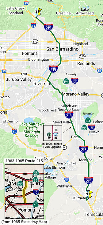 From Route
  Route 214
 Route 216