
 California Highways:
Click here for a key to the symbols used. An explanation of acronyms may be found at the bottom of the page.
 Routing
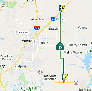 From Route 12 to Route 80 near Dixon.
 Post 1964 Signage History
The definition of this segment is unchanged from 1963.
 Pre 1964 Signage History
This was LRN 101, defined in 1933. It was not signed as Route 113 before 1964, although the portion through Dixon was part of US 40.
Tom Fearer provides more information on US 40 in Dixon: The current route
of Route 113 in Dixon along 1st Street from Adams Street north I-80 was
part of the original path of US 40/LRN 7. US 40 originally traversed Dixon
using the following alignment eastbound from Vacaville:
(Source: Gribblenation Blog: California State Route 113; a little bit of vintage US 40, US 40A, US 99W and CA 24, 2/24/2019)
By 1942 US 40/LRN 7 was moved to new alignment between Dixon east to Davis which is on the present grade of I-80.
Signed Route 113 was not defined as part of the initial state signage of routes in 1934. It is unclear what (if any) route was signed as Route 113 between 1934 and 1964. It appears that Signed Route 113 came about as the result of removing the Alternate US 40 designation from the Woodland to Tudor, and removing the Alternate US 40/US 99W designation from the portion S of Woodland.
 Status
In January 2024, Caltrans released the draft 2024 SHOPP, which contained
the following long-lead project: 04-Solano-113 8.5 / 19.0; PPNO 04-2915L;
ProjID 0422000131; EA 4W260. Route 113 In and near Dixon, from 0.5 mile
north of Cook Lane to West Chestnut Street. Rehabilitate roadway and
drainage systems, widen and realign roadway, widen and/or replace bridges,
add Class 2 bike lanes, construct stormwater treatment Best Management
Practices (BMPs), and upgrade facilities to Americans with Disabilities
Act (ADA) standards. (Long Lead Project) Note: Due to floodplain analysis,
substantial right of way acquisition, and significant utility relocations
anticipated along with environmental impacts involving several permits.
Proposed ($ × 1000): PA&ED: $4,310; PS&E: $6,880; R/W $7,306;
R/W Sup $2,646; Con $123,523; Con Sup: $16,645; Total: $161,310. Only
PA&ED phase is authorized. Begin Con: 10/1/2031.
(Source: 2024 Draft SHOPP v4.0, 1/31/2024)
Fairfield Roundabout (04-Sol-12, PM 19.2)
In May 2017, the CTC approved for future consideration of funding a project in Solano County that proposes to improve safety for vehicles at the intersection of Route 12 and Route 113 (04-Sol-12, PM 19.2) by installing a single lane roundabout, light poles and advance warning signs. This project is programmed into the 2016 SHOPP for $7,122,000 in Construction (capital and support) and Right of Way (capital and support). Construction is estimated to begin in 2018. The scope, as described for the preferred alternative, is consistent with the project scope programmed by the Commission in the 2016 State Highway Operation and Protection Program.
In May 2018, it was reported that Caltrans expects to
hire a contractor to construct a roundabout at Route 12 and Route 113 in
September 2018, with work starting as early as December. The estimated
cost for the entire project is $7.1 million, of which $4.67 million is
construction costs, Caltrans reports. It is funded through the State
Highway Operation and Protection Program.
(Source: Solano Daily Republic, May 2018)
In August 2018, the CTC approved approved an allocation of $7,398,000 for the SHOPP Roadside Safety Improvement project (PPNO 8060A) on Route 12 and Route 113 in Solano County. This is a safety project which will reduce the number and severity of collisions at the existing highspeed and high-truck traffic intersection of Route 12 and Route 113 near the city of Rio Vista in Solano County. Route 12 is a major east-west corridor between I-80 and I-5, and intersects with Route 113/Birds Landing Road, forming a four-legged intersection controlled by two-way stop signs. The project is within an environmentally sensitive area, with creek crossings on both Route 12 and Route 113, requiring an Incidental Take Permit (ITP) for the California Tiger Salamander (CTS) from the California Department of Fish and Wildlife (CDFW).
The California Department of Fish and Wildlife issued the Incidental Take Permit (ITP) for the project in June 2018 with the condition of a security deposit as funding assurance to ensure successful completion of mitigation and any follow-up compliance activities. The mitigation also includes 10 years of “off-site” habitat management, monitoring and reporting on the status of compensatory habitat. Caltrans is legally precluded from transferring funds “in trust” to another entity as security. On August 10, 2018, after extensive negotiations with the California Department of Fish and Wildlife, it was agreed that the ITP’s security deposit condition would be satisfied by a separate mitigation “child” project to be split from this “parent” project at the time of allocation.
Both Route 12 and Route 113 belong to the Terminal Access Network, under the Surface Transportation Act of 1982, which is a highway network that accommodates trucks longer than California standard legal length. Route 12 is also a major Department of Defense truck route that serves as a key corridor for shipments in and out of Travis Air Force Base. Route 12 has an 11 percent truck volume and an Annual Average Daily Traffic (AADT) of 15,000 vehicles, which current traffic data indicates is significantly greater than the statewide average accident rate.
This project features a single-lane roundabout with an approach to splitter islands, center truck apron, aesthetically treated center island, and advance flashing beacons. The Department conducted the Intersection Control Evaluation (ICE) and determined the single-lane roundabout alternative to be more effective operationally than the signalized intersection design. An independent consultant was hired by the Department to further review the design to ensure the safety of the high-speed traffic of the roundabout. The consultant’s recommendation was to modify the design to a larger roundabout utilizing additional safety measures.
The needed construction capital cost increase is due to
modifying the initial standard roundabout to a larger roundabout footprint
within the existing right-of-way, as recommended by the consultant, and
the additional safety traffic design measures associated with the larger
roundabout. The needed construction support cost increase is due to the
additional working days needed to accommodate construction staging and to
address environmental permit requirements.
(Source: August 2018 CTC Agenda Item 2.5d.(1))
In October 2018, the CTC amended the following project
into the 2018 SHOPP: 04-Sol-12 19.2/19.4. PPNO 8060B. Project 0419000066.
EA 4G561. Route 12 Near Rio Vista, at the intersection of Route 12 and
Route 113; also on Route 113 from PM 0.0/0.2. Environmental mitigation for
safety project EA 4G560. Note: Split off environmental mitigation work to
provide funding assurance to California Department of Fish and Wildlife
(CDFW) for EA 4G560/PPNO 04-8060A.
(Source: October 2018 CTC Agenda Item 2.1a.(1) Item
11)
In April 2019, it was reported that construction of the roundabout at Route 12 and Route 113, between Suisun City and Rio Vista, would begin at the end of April 2019.
In September 2019, it was reported that there are
increased concerns about the new roundabout under construction at Route 12
and Route 113, between Suisun City and Rio Vista. The concerns relates to
crashes during construction, specifically a recent crash where, according
to Solano CHP, an 80-year-old man driving a silver Toyota Prius was
traveling westbound on Route 12 at an undetermined speed Wednesday, when
he collided head-on with the raised concrete portion of the new
roundabout, killing him and his 79-year-old female passenger. The worry is
that the speeds on the highway (55 mph) would lead to more accidents.
According to Caltrans, roundabouts on highways do make sense and are a
proven way to cut down on traffic collisions. Caltrans statistics show
that “roundabouts reduce the number of crashes by 37% and injury
crashes by 75%”. Additionally the shape of the roundabout also
results in lower speeds, generally 15-20 mph less. This does mean that the
roundabout will likely cause a bit of a traffic backup during peak commute
times but slower moving traffic means it's doing its job. Despite the
statistics, locals also think the roundabout was made too narrow for the
big rigs and farm equipment that travel the highway, many of them now
using the curb to navigate the counterclockwise turns of the circle.
(Source: KRCA 3, 9/20/2019)
Downtown Dixon Bypass (~ SOL 17.261 to SOL 21.013)
Solano County is conducting a study regarding bypassing downtown Dixon. Dixon made a push in the mid-1990s to have the state relocate the highway to rural Midway and Pedrick roads. But widening and improving Pedrick Road and improving the interchange at I-80 was too expensive, and Caltrans indicated they didn't have the funds. They offered to let Dixon pay, but the city declined. Now Dixon wants the Solano Transportation Authority to do a study on Route 113.
In December 2016, I received an email that the STA study has been completed. Short term solutions include Baseline Transportation Management Systems, Traffic Demand Management and Intelligent Transportation Systems; upgrading the existing sharp curves along Route 113 to standard Caltrans design speed with a curve radius of 1,700 feet and a design speed of 65 MPH; installing a full traffic signal at Route 113 and Route 12 to maintain a safe and efficient movement at this intersection (together with intersection improvements), and rehabbing the pavement. Mid-term recommendations include widening lanes along Route 113 to the standard 12 foot lane width to enhance safety features, together with shoulder improvements for safety; upgrading the shoulders to 8-feet and 20-feet undivided median along Route 113 from Route 12 to Midway Road; and constructing passing lanes along Route 113 between Route 12 and Midway Road (maintaining a two-lane facility). Long-term improvements, which require significant funding, include realignment of Route 113, north of Midway to I-80, with a two-lane facility with standard shoulders and median (construction of a four-lane facility can be postoned until traffic volumes warrant such a facility; with this option, the old Route 113 alignment north of Midway Road would revert back to a local (City or County) maintained roadway); together with upgrading the I-80 interchange. Even longer-term recommendations are upgrading the route to a four-lane facility; grade separation of Route 113 and the UPRR as well as Route 113 and Route 12, and having direct ramp connectors for the I-80/Route 113 interchange. The study noted that during the last 20 years, there has not been a comprehensive corridor study for Route 113, and it remains one of the last corridors in Solano County with no major investment study. A Route Concept Report (fact sheet only) was completed in May 1985 for Route 113. It was anticipated that traffic will increase along Route 113 in conjunction with the anticipated developments in Solano and Yolo Counties. In addition, the anticipated land use and traffic growth in the Central Valley, Sacramento, and San Francisco Bay Area regions will also impact this corridor.
In June 2008, the CTC approved relinquishment of right of way in the city of Dixon, between West Chestnut Street and 0.1 mile north of West F Street (~ SOL 19.014 to SOL 19.647), consisting of non-motorized transportation facilities, namely sidewalks.
 Classified Landcaped Freeway
The following segments are designated as Classified Landscaped Freeway:
| County | Route | Starting PM | Ending PM |
| Solano | 113 | R21.65 | R21.94 |
| Solano | 113 | R21.99 | R22.22 |
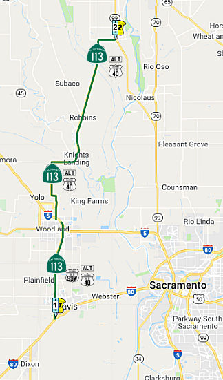 From Route 80 near Davis to Route 99 passing near Woodland.
Post 1964 Signage HistoryThe definition of this segment is unchanged from 1963.
At times, portions were co-signed as "Temporary" I-5. This is discussed in detail with Route 99.
Pre 1964 Signage HistoryBetween I-80 and I-5, this was part of LRN 7 (defined in 1909), and was cosigned as US 99W/Alternate US 40. Between I-5 and Route 99, this was part of LRN 87, defined in 1933. It was originally part of Sign Route 24, and in 1954 became part of US 40A. The Sign Route 24 designation was dropped around 1960 when Route 24 was transferred to a new routing along LRN 232 (although it may have been dropped when the route was resigned as US 40A in 1954). Sign Route 113 was not defined in the initial set of signed routes in 1934.
 In 1954, Sign Route 24 was either co-signed or resigned as Alt US 40
(US 40A). The article announcing the designation indicated that existing
signs would be replaced by US 40 signs with the designation "Alt". The
article indicated that for the first 10 miles N, from US 40 in Solano
County, the new alternate route would be designated as US 99W and US 40A.
A new section of highway was being constructed to intersect with the
existing US 99W at the Woodland Wye. This would be the segment that is now
Route 113. In Woodland, US40A joined with the existing US 99W / Sign Route 24 to Yuba City; this is now Route 113. US 40A then followed Sign Route 24
(now Route 70) through Oroville and Quincy to US 395. Lastly, US 40A
followed US 395 S to Reno, which was the eastern terminus of US 40A. The
goal here was to provide an alternate route across the Sierras when Donner
Pass was closed.
In 1954, Sign Route 24 was either co-signed or resigned as Alt US 40
(US 40A). The article announcing the designation indicated that existing
signs would be replaced by US 40 signs with the designation "Alt". The
article indicated that for the first 10 miles N, from US 40 in Solano
County, the new alternate route would be designated as US 99W and US 40A.
A new section of highway was being constructed to intersect with the
existing US 99W at the Woodland Wye. This would be the segment that is now
Route 113. In Woodland, US40A joined with the existing US 99W / Sign Route 24 to Yuba City; this is now Route 113. US 40A then followed Sign Route 24
(now Route 70) through Oroville and Quincy to US 395. Lastly, US 40A
followed US 395 S to Reno, which was the eastern terminus of US 40A. The
goal here was to provide an alternate route across the Sierras when Donner
Pass was closed.
(Source: Roseville Press-Tribune 3/23/1954 via Joel Windmiller
(email), 11/12/2023)
Tom Fearer provides more details on the US 40A and US 99W routings: US 40
east met US 99W in Davis, and both routes continued east to Sacramento on
LRN 6. US 99W occupied the rest of the LRN 7 corridor north through
Woodland where Route 113 now meets I-5. LRN 7/US 99W continued north to
Red Bluff where it met LRN 3/US 99E. The original route of US 40 through
Davis from the Solano County line eastward is as follows:
(Source: Gribblenation Blog: California State Route 113; a little bit of vintage US 40, US 40A, US 99W and CA 24, 2/24/2019)
In 1935, US 99W/US 40 entered Davis on LRN 6 via Olive Drive.US 99W split
onto LRN 7 via Richards Boulevard over the Southern Pacific Railroad. US 99W/LRN 7 northbound traversed Davis via Richards Boulevard, 1st Street, B
Street and Russell Boulevard. From Russell Boulevard, US 99W/LRN 7
northbound followed the grade of the current Route 113 and East Street to
Main Street in Woodland. US 99W/LRN 7 in Woodland followed Main Street and
Route 16/County Road 98.
(Source: Gribblenation Blog (Tom Fearer), "Former US Route 99 West from West Sacramento to Red Bluff", August 2021)
In 1942, the Dixon-Davis Cutoff alignment of US 40/LRN 6 was
completed. This provided a new bypass route of US 99W/US 40/LRN 6
around Davis. US 99W/LRN 7 branched from US 40/LRN 6 via what is now
Pedrick Road. US 99W/LRN 7 followed Pedrick Road and Russell
Boulevard towards the grade of the modern Route 113 freeway.
(Source: Gribblenation Blog (Tom Fearer), "Former US Route 99 West from West Sacramento to Red Bluff", August 2021)
By 1942 US 40 on the LRN 7 corridor bypassed around Davis roughly on the
alignment of present I-80. The route of US 99W on LRN 7 north from US 40
through Woodland originally used the following alignment:
(Source: Gribblenation Blog: California State Route 113; a little bit of vintage US 40, US 40A, US 99W and CA 24, 2/24/2019)
By 1955 a new direct link route for US 99W from US 40 to East Street
appears on the State Highway Map. Said junction of US 99W/US 40 was also
the origin point of US 40A. US 40A split from US 99W in Woodland on LRN 87
which was previously occupied by Route 24. US 40A followed the current
Route 113 corridor on LRN 87 to Tudor.
(Source: Gribblenation Blog: California State Route 113; a little bit of vintage US 40, US 40A, US 99W and CA 24, 2/24/2019)
In 1958, the freeway upgrade to existing US 40/LRN 6 from the Solano
County Line east to the US 99W/US 40A/LRN 7 interchange in Davis was
budgeted.
(Source: Gribblenation Blog (Tom Fearer), "Former US Route 99 West from West Sacramento to Red Bluff", August 2021)
The portion of Route 113 that bypasses Davis (between Russell Bouelvard
and current I-80) goes through land that was originally part of UC Davis
agricultural research. When this segment was upgraded to freeway around
1976, part of Hutchison Drive, a university street, had to be rerouted for
an interchange; the old segment now stubs off on the west side of the
freeway.
(Source: Chris Sampang)
Former US 99W on Route 113 from Davis north towards County Road 29 was
upgraded to freeway standards by 1976.
(Source: Gribblenation Blog (Tom Fearer), "Former US Route 99 West from West Sacramento to Red Bluff", August 2021)
The full Route 113 freeway from Davis to Woodland was completed in 1990
after lobbying by the City of Woodland and Woodland's Chamber of Commerce.
It appears that the segment from I-5 to Main Street (former Route 16/current Business I-5) was built first, in 1973. The segment from I-80
in Davis north to County Road 27 was constructed from 1974-1976. So until
1990, Route 113 continued north on East Street from County Road 27 to the
current north I-5/Route 113 junction, through downtown Woodland. This
explains why one large sign gantry still exists at East and Main (former
Route 16) for Route 113; the sign itself dates back to the early 1960s and
has shieldout for US 99W. After the Route 113 freeway was completed, East
Street's connection to County Road 27 via Rose Lane (over a Southern
Pacific railroad crossing halfway between County Road 25A and County Road
27) was severed.
(Source: Chris Sampang)
Signed Route 113 was not defined as part of the initial state signage of routes in 1934. It is unclear what (if any) route was signed as Route 113 between 1934 and 1964. It appears that Signed Route 113 came about as the result of removing the Alternate US 40 designation from the Woodland to Tudor, and removing the Alternate US 40/US 99W designation from the portion S of Woodland.
 Freeway
[SHC 253.6] From from Route 80 near Davis to Route 99 near Tudor. Added to the Freeway and Expressway system in 1963.
 In November 1959, California Division of Highways published route adoptions
for the Westside Freeway (I-5). This also included adopted routes for
California 16 & Alt US 40 Alt & US 99W (post-1964 Route 113 and
Route 16) in Woodland, Yolo County.
In November 1959, California Division of Highways published route adoptions
for the Westside Freeway (I-5). This also included adopted routes for
California 16 & Alt US 40 Alt & US 99W (post-1964 Route 113 and
Route 16) in Woodland, Yolo County.
(Source: Joel Windmiller, California's Historic Highways on FB, 5/31/2020)
StatusRecently, the portion between the segments (~ SOL 21.08 to SOL R21.848R; Route 80 ~ SOL 38.318 to SOL 42.629) has been co-signed as Route 113/I-80. A Route 113 shield has been added to the eastbound I-80 trailblazer assembly just past the junction of Route 113 in Dixon, and a similar arrangement can be found on WB I-80 just past the Route 113 junction in Davis. There are no Route 113 shields on the trailblazer assemblies at the interchanges in between Dixon and Davis.
Freeway is completed from Davis (~ SOL R22.197) to Woodland (~ YOL 11.296) (Route 80 to Route 5), approx 12 miles.
In August 2011, the CTC approved $7,500,000 in SHOPP funding for repairs from Davis (~ SOL R22.197) to Woodland (~ YOL 11.296) that will rehabilitate 45.0 lane miles of roadway to improve the ride quality, prevent further deterioration of the traveling surface, minimize costly roadway repairs and extend the pavement service life.
 In February 2023, it was reported that Woodland was applying for a grant through the Sacramento
Area Council of Governments is up to $5 million related to the
construction of freeway connectors between I-5 and Route 113. During the
early 2000s, a project to build freeway-to-freeway connectors between I-5
and Route 113 in Woodland enjoyed significant regional support, and by the
end of the early 2000s, the city achieved project plans that were 95%
complete and completed 87% of the property acquisition. However, the
project struggled to obtain funding due to its construction cost and the
city approached the Yolo County Transportation District board in 2011 with
a proposal to prioritize the reconstruction of Kentucky Avenue while
keeping the project funded through the Sacramento Area Council of
Governments. In 2023, based on increased federal infrastructure funding,
the city proposed to reengage on the advocacy and completion of this
project.
In February 2023, it was reported that Woodland was applying for a grant through the Sacramento
Area Council of Governments is up to $5 million related to the
construction of freeway connectors between I-5 and Route 113. During the
early 2000s, a project to build freeway-to-freeway connectors between I-5
and Route 113 in Woodland enjoyed significant regional support, and by the
end of the early 2000s, the city achieved project plans that were 95%
complete and completed 87% of the property acquisition. However, the
project struggled to obtain funding due to its construction cost and the
city approached the Yolo County Transportation District board in 2011 with
a proposal to prioritize the reconstruction of Kentucky Avenue while
keeping the project funded through the Sacramento Area Council of
Governments. In 2023, based on increased federal infrastructure funding,
the city proposed to reengage on the advocacy and completion of this
project.
(Source: MSN, 2/15/2023)
Knights Landing/Leiser Road Curve Realignment (03-Sut-113 0.4/1.1)
In October 2022, the CTC amended the following project
into the SHOPP: 03-Sut-113 0.4/1.1. PPNO 03-8508; ProjID 0322000146; EA
2J980. Route 113 Near Knights Landing, from north of Yolo County line to
south of Leiser Road. Curve realignment. Allocation ($ × 1,000):
PA&ED $1,140; PS&E $980; R/W Sup $320; Con Sup $1,050; R/W Cap
$890; Const Cap $4,250; TOTAL $8,630. Begin Const: 7/1/2026.
(Source: October 2022 CTC Agenda, Agenda Item
2.1a.(1d) #17)
In October 2022, the CTC approved the following
pre-construction phase allocation: $1,140,000. 03-Sut-113 0.4/1.1. PPNO
03-8508; ProjID 0322000146; EA 2J980. Route 113 Near Knights Landing, from
north of Yolo County line to south of Leiser Road. Curve
realignment. Allocation: PA&ED $1,140,000. Concurrent Amendment under
SHOPP Amendment 22H-004; October 2022.
(Source: October 2022 CTC Agenda, Agenda Item 2.5b.(2a) #4)
 Naming
 The portion of Route 113 between I-80 and I-5 (~ SOL
R21.977R to YOL R10.649) is named the "Vic Fazio Highway".
Vic Fazio, a United States Representative for ten consecutive terms
beginning in 1978, secured funds to provide a continuous four lane freeway
for the portion of Route113 between I-5 and I-80, replacing a prevoius
"blood alley". Named by Assembly Concurrent Resolution 100, Chapter 124,
in 1998.
The portion of Route 113 between I-80 and I-5 (~ SOL
R21.977R to YOL R10.649) is named the "Vic Fazio Highway".
Vic Fazio, a United States Representative for ten consecutive terms
beginning in 1978, secured funds to provide a continuous four lane freeway
for the portion of Route113 between I-5 and I-80, replacing a prevoius
"blood alley". Named by Assembly Concurrent Resolution 100, Chapter 124,
in 1998.
(Image source: Gribblenation; Davis Enterprise)
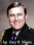 The interchange of Route 5 and Route 113 (~ YOL
R10.649) is named the "CHP Sergeant Gary R. Wagers Memorial Interchange"
This interchange was named in memory of CHP Sergeant Gary R. Wagers, who
died in a patrol vehicle collision in the line of duty while pursuing a
traffic violator at high speed in the early morning hours of March 15,
2001, on Route 113 at the interchange with Route 5, in Woodland. Sergeant
Wagers graduated high school in Allegan, Michigan and was a graduate of
California State University, Sacramento. He joined the California Army
National Guard in 1970 and retired in 1998 at the rank of Lieutenant
Colonel, after receiving many awards, including the Army Achievement
Medal, Reserve Commendation Medal, Meritorious Service Medal, and the
National Defense Medal. He graduated from the California Highway Patrol
Academy and was appointed as a State Traffic Officer on August 9, 1979; he
was promoted to the rank of State Traffic Sergeant on March 1, 1992. He
served in the West Los Angeles, Westminster, South Sacramento, Riverside,
Santa Ana, and Woodland Areas as well as at CHP Headquarters and
California Highway Patrol Air Operations. Named by Assembly Concurrent
Resolution (ACR) 16, Resolution Chapter 70, on 07/07/2005.
The interchange of Route 5 and Route 113 (~ YOL
R10.649) is named the "CHP Sergeant Gary R. Wagers Memorial Interchange"
This interchange was named in memory of CHP Sergeant Gary R. Wagers, who
died in a patrol vehicle collision in the line of duty while pursuing a
traffic violator at high speed in the early morning hours of March 15,
2001, on Route 113 at the interchange with Route 5, in Woodland. Sergeant
Wagers graduated high school in Allegan, Michigan and was a graduate of
California State University, Sacramento. He joined the California Army
National Guard in 1970 and retired in 1998 at the rank of Lieutenant
Colonel, after receiving many awards, including the Army Achievement
Medal, Reserve Commendation Medal, Meritorious Service Medal, and the
National Defense Medal. He graduated from the California Highway Patrol
Academy and was appointed as a State Traffic Officer on August 9, 1979; he
was promoted to the rank of State Traffic Sergeant on March 1, 1992. He
served in the West Los Angeles, Westminster, South Sacramento, Riverside,
Santa Ana, and Woodland Areas as well as at CHP Headquarters and
California Highway Patrol Air Operations. Named by Assembly Concurrent
Resolution (ACR) 16, Resolution Chapter 70, on 07/07/2005.
(Image Source: Calif Assn of Highway Patrolmen)
 Named Structures
Bridge 18-0032, the Sutter Causeway Bridge in Sutter county (SUT R010.8), is named the "Leslie A. Lowden Memorial Bridge". It was built in 1968, and named by Assembly Concurrent Resolution 34, Chapter 65, in 1991. Leslie A. Lowden, descendant of California pioneers, community activist, mother and grandmother, was killed by a drunk driver on July 25, 1989.
 Other WWW Links Classified Landcaped Freeway
The following segments are designated as Classified Landscaped Freeway:
| County | Route | Starting PM | Ending PM |
| Yolo | 113 | R0.25 | R0.57 |
| Yolo | 113 | R0.95 | R1.26 |
| Yolo | 113 | R1.94 | R2.20 |
| Yolo | 113 | R10.29 | R10.67 |
 Interregional Route
 Historical Route
Assembly Concurrent Resolution 180, 1998, designated those portions of US 40 that are still publically maintained and not already designated as part of Historic US 40 as "Historic US 40".
Senate Concurrent Resolution 66, Chaptered May 18, 2006 (Resolution Chapter 51), designated, upon application by an appropriate local governmental agency, any section of former Alternate U.S. Highway Route 40 that is still a publicly maintained highway and that is of interest to the applicant, as Historic Alternate U.S. Highway Route 40. This recognizes the role that Former Alternate U.S. Highway Route 40 played in the development of the transportation routes into California over what is now known as the Davis "Y". Alternate U.S. Highway Route 40 is currently Route 113 from Davis to Woodland and Yuba City, and Route 70 through Marysville, Oroville, and the Feather River Canyon to Hallelujah Junction on Route 395, a route that today serves 27 towns and the six counties of Yolo, Sutter, Yuba, Butte, Plumas, and Lassen. The Feather River Scenic Byway is a 130 mile segment of Route 70, which was part of Alternate US 40.
 Exit Information Other WWW Links
 Interstate Submissions
In April 1958, it appears that the designation I-113 was proposed for the route that is now I-680. This was part of the first attempt to assign 3-digit interstates n California. The number was rejected by AASHTO.
 Statistics
Overall statistics for Route 113:
 Pre-1964 Legislative Route
In 1933, Chapter 767 added the route from "[LRN 2] near Mountain View to [LRN 5] near Milpitas" to the highway system. In 1935, it was codified into the highway code as LRN 113 without change. The route remained unchanged until the 1963 renumbering. It ran from US 101 near Mountain View to present-day I-680 near Milpitas. It was originally part of Route 9; it is present-day Route 237.
© 1996-2020 Daniel P. Faigin.
Maintained by: Daniel P. Faigin
<webmaster@cahighways.org>.
 Route 112
 Route 114