
 California Highways:
Click here for a key to the symbols used. An explanation of acronyms may be found at the bottom of the page.
 Routing
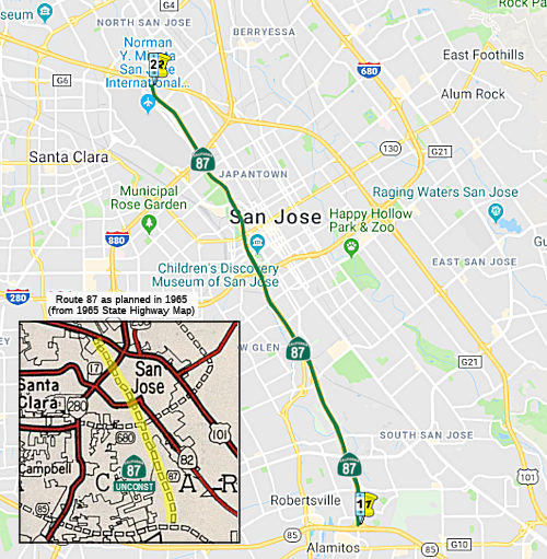 From Route 85 in the vicinity of Santa Teresa Boulevard to Route 101 in the
vicinity of Guadalupe River.
From Route 85 in the vicinity of Santa Teresa Boulevard to Route 101 in the
vicinity of Guadalupe River.
 Post 1964 Signage History
As defined in 1963, this segment was defined as:
Route 85 in the vicinity of Pearl Avenue to Route 101 in the vicinity of Guadalupe River.
Subdivision (a) of Route 87 shall be added to the state highway system at the time the City of San Jose and the County of Santa Clara have acquired all rights-of-way necessary to construct a freeway on this route to state freeway standards and have conveyed said rights-of-way to the State without charge; provided, that the commission and the department may take all steps necessary to locate and design said freeway or any portion thereof prior to the time it is added to the state highway system.
In 1965, Chapter 65 allowed construction to begin, changing the caveat to “Construction of subdivision (a) of Route 87, or any portion thereof, may be commenced at the time the City of San Jose and the County of Santa Clara have acquired all rights-of-way necessary to construct a freeway, or any portion thereof, on this route to state freeway standards and have conveyed said rights-of-way to the State without charge.” This was done to permit Route 87 to be incorporated into the design of I-680, then planned to start construction in 1968.
In 1969, Chapter 1179 changed the caveat on (a) again: “Notwithstanding the provisions of Section 89 of Chapter 1062 of the Statutes of 1959, construction of subdivision (a) of Route 87 may be commenced at any time, if the City of San Jose and the County of Santa Clara has conveyed or does convey to the State of California, without charge, all real property presently acquired by it for the construction of said subdivision (a) of this route or such portion thereof.”
In 1980, Chapter 777 removed all conditions on this segment.
In 1988, Chapter 106 changed the origin of this segment to be “Route 85 in the vicinity of Santa Teresa Boulevard”
The history of the construction of this portion is as follows:
Sparker on AAroads provided some interesting history on this segment:
(Source: Sparker on AAroads, "Re: LA Times - High Desert Highway", 2/26/2019)
From the '60's forward to recent years, the city of San Jose by and large was looking to enhance their downtown area and wanted to provide access to the greatest number of inbound folks regardless of mode of transport. There was an downtown easement provided for the Route 87 freeway; north from there it had always been assumed that the alignment would subsume the Guadalupe Parkway that had been developed in the '60's. The alignment to the south had been adopted in the early '60's as well; the Route 87/I-280 interchange near downtown was fully built (with stub-ends in both directions) as part of the original I-280 construction in the late '60's and early '70's. Up until the late '80's the city government wanted it, Caltrans wanted to get cracking on it back then, and the downtown businesses definitely wanted Route 87 built and supplying potential customers. But the transit/LR push in the late '80's that culminated in the first phase of VTA LR being built up and down First Street signaled a major policy shift within the city; if it were not for the alteration of Route 87 plans south of downtown -- along with several miles of Route 85 to the southeast -- placing the LR line in the freeway median, the whole thing might well not have been fully built. The northern part was "sold" to city planners as the only way to expedite traffic to and from the airport to downtown. In the meantime, the Guadalupe River, adjacent to the northern half of the Route 87 corridor, was declared a riparian reserve -- so the north half of Route 87 required a redesign to preserve river space, which flanks the ROW along its west side. Also, the management of Mineta Airport argued against a Route 87/I-880 interchange, which sat at the corner of the airport only a quarter-mile away from one of the main runways; any flyovers were considered to pose potential interference issues with airport operations. Although this omission meant a lack of a direct downtown SJ-to-Oakland connection, the interchange was erased from the freeway's plans. But although some planners wished to omit the freeway south of I-280 and simply run the LR line down the ROW, it was the design of the whole thing that combined LR terminals with the various overpasses and undercrossings along the freeway that saved the project; dropping the freeway would have entailed a complete LR redesign -- and a corresponding delay of several years. Still, most of the downtown businessmen, the chamber of commerce, and D4 itself maintained an unflagging resolve to get Route 87 built despite increasing opposition from some quarters.
 Pre 1964 Signage History
This segment was LRN 292, defined in 1961. It was unsigned in 1963. Note: the 1961 law said "Route 239 in the vicinity of Pearl Avenue", but this was technically an error as Route 239 was moved from Route 85 to Route 17 by Chapter 1146 in 1961. Chapter 1698 in 1963 corrected the definition of LRN 292, but of course, it was overtaken by the 1963 renumbering (Chapter 385). It was not signed in Route 87 was not defined in the initial set of state signed routes in 1934.
 Status
In June 2017, it was reported that the Santa Clara Valley Transportation
Authority and San Jose city officials recently approved a $225,000 study
that will examine the feasibility of creating flex lanes on Route 87. The
study will focus on traffic congestion along the 87 corridor between Route 85 and US 101 (i.e., the entire route) and explore different ways to
alleviate traffic jams. San Jose Councilman Johnny Khamis, whose District
10 encompasses a large stretch of Route 87, says he’d like to see
one extra traffic lane created on each side of the freeway. Both lanes
would start at Route 85 and extend north to I-280 (~ SCL 0.078 to SCL
5.33). Flex lanes serve as an extra traffic lane during commute hours and
as a regular shoulder the rest of the time. A consultant will study such
factors as narrowing all the lanes and by how much to accommodate the
extra lane. A decision on whether that flex lane should also require a
toll during commute hours “will not be made until we find out if the
lane will fit.” The study was initiated in response to complaints
from residents about traffic around the Almaden Ranch shopping center.
Consideration is also being given to removing the right-hand shoulder
between the Route 87 on-ramp for a quarter-mile up to Route 85 northbound
and creating a dedicated exit lane. All modes of travel will be explored
during the study, according to VTA officials, who will start requesting
proposals from consultants this summer. Funding for the study is being
split, with $150,000 from the VTA and $75,000 from the city of San Jose.
VTA officials expect the study to be finished by the end of the year.
Adding an extra lane would require repaving the road in addition to
restriping. No estimates or funding sources for construction have yet been
supplied.
(Source: Mercury News, 6/1/2017)
I-280 to US 101 near the San Jose Airport.
In June 2002, the CTC considered a STIP project to update the existing four lane highway to a six lane freeway with HOV lanes from Julian St to US 101 (~ SCL 6.116 to SCL 9.15) . This was completed in 2004.
In June 2015, the CTC authorized the relinquishment of three segments along Route 87: (1) right of way in the city of San Jose along Guadalupe Parkway from Coleman Avenue to West Hedding Street, consisting of reconstructed city streets; right of way in the city of San Jose at Skyport Drive, consisting of a reconstructed city street; and (3) right of way in the city of San Jose at Airport Parkway, consisting of reconstructed city streets. (04-SCl-87-PM 6.5/7.3, 04-SCl-87-PM 8.4, 04-SCl-87-PM T8.8)
The route has two Single-Point Urban Interchanges (SPUIs): one at Taylor Street (~ SCL 6.916), the other at a new road going into San Jose International Airport (~ SCL 8.372).
There is a rationale for the lack of a connector between Route 87 and
I-880 (~ SCL 7.519). The two freeways are close to the eastern edge of
Mineta San Jose International Airport, meaning that elevated ramps cannot
be built without interfering in the flight path. Route 87 runs parallel to
the Guadalupe River, so tunneling to link the freeways does not work. One
corner of the crossover is the light-rail maintenance yard for the Valley
Transportation Authority, which cannot be easily or cheaply moved. Exits
from Route 87 to Taylor Street and from I-880 to Coleman Avenue and First
Street are less than a ¼ mi away, and Caltrans requires that ramps be
at least a mile apart to avoid merging chaos. Lastly, high-voltage power
lines run through the area, which would be costly to relocate.
(Source: Thanks to Gary Roberts "Mr. Roadshow" for hunting down this
information)
In April 2002, the CTC considered STIP Project #3 [Agenda Item 2.5b.(1)], which would upgrade the current 4 lane highway to a six-lane freeway with HOV lanes from 0.5 km N of I-880 (SCL 8.0) to 0.6 km N of Airport Parkway (SCL 9.0).
 Naming
 The portion of this route completed to freeway standards is named the "Guadalupe Freeway" or "Guadalupe Parkway".
(Image source: Corco Highways)
 The portion of Route 87 between Route 85 and I-280 in the City of San Jose
(~SCL 0.097 to SCL 5.198) is named the "San Jose Police Officer
Michael Johnson Memorial Highway". It was named in memory of San
Jose Police Officer Michael “Mike” Jeremiah Johnson , who was
born in December 1976. At the time he was born, Mike’s father,
Daniel Johnson, was a military police officer in the United States Army,
who, after his discharge from the army, became a member of the Calaveras
County Sheriff’s Department, and Mike and his family moved to
Wilseyville, California. In 1988, Mike and his family moved to the City of
San Jose, where Mike attended Gunderson High School and became captain of
the school’s chess team. Mike’s first job was delivering
newspapers on his bicycle for the San Jose Mercury News, and, after
graduation from high school in 1995, Mike took classes at West Valley
College while working as an audio-visual specialist at Radio Shack and
later at The Good Guys electronics store. He began studying jujitsu,
ultimately earning a black belt and becoming an instructor to children.
Mike’s ultimate goal and desire was to become a police officer and
serve his community. Mike joined the San Jose Police Academy in 2001 and
graduated on June 15, 2001. As a member of San Jose’s police force,
Officer Johnson was a dedicated and highly regarded officer who had a
strong sense of duty and great pride in being a police officer. He was
beloved in the community because he always had a genuine smile and a
natural ability to engage people in conversation. On March 24, 2015,
Officer Johnson and his partner, Doug Potwora, responded to an emergency
call involving a suicidal man who was threatening his wife in a domestic
violence dispute. When they arrived, the suspect, armed with a
high-powered rifle, opened fire on the officers from behind an enclosed
balcony. Tragically, the suspect fatally shot Officer Johnson. The suspect
was later shot and killed by Officer Potwora, whose heroic efforts likely
saved several more lives. During his 14 years with the San Jose Police
Department, Officer Johnson worked as a patrolman and court liaison. He
also specialized in prescription drug fraud crimes and had recently been
promoted to field training officer. Officer Johnson was a member of the
Specialist Rifle Program and an expert marksman. He proved his skills each
year when he and his father competed together at the United States Police
and Fire Championships, where he won numerous medals. Officer Johnson will
be inducted into the Police and Fire Championships’ Hall of Fame in
2015. Named by Assembly Concurrent Resolution 88, Resolution Chapter 186,
on 09/21/15.
The portion of Route 87 between Route 85 and I-280 in the City of San Jose
(~SCL 0.097 to SCL 5.198) is named the "San Jose Police Officer
Michael Johnson Memorial Highway". It was named in memory of San
Jose Police Officer Michael “Mike” Jeremiah Johnson , who was
born in December 1976. At the time he was born, Mike’s father,
Daniel Johnson, was a military police officer in the United States Army,
who, after his discharge from the army, became a member of the Calaveras
County Sheriff’s Department, and Mike and his family moved to
Wilseyville, California. In 1988, Mike and his family moved to the City of
San Jose, where Mike attended Gunderson High School and became captain of
the school’s chess team. Mike’s first job was delivering
newspapers on his bicycle for the San Jose Mercury News, and, after
graduation from high school in 1995, Mike took classes at West Valley
College while working as an audio-visual specialist at Radio Shack and
later at The Good Guys electronics store. He began studying jujitsu,
ultimately earning a black belt and becoming an instructor to children.
Mike’s ultimate goal and desire was to become a police officer and
serve his community. Mike joined the San Jose Police Academy in 2001 and
graduated on June 15, 2001. As a member of San Jose’s police force,
Officer Johnson was a dedicated and highly regarded officer who had a
strong sense of duty and great pride in being a police officer. He was
beloved in the community because he always had a genuine smile and a
natural ability to engage people in conversation. On March 24, 2015,
Officer Johnson and his partner, Doug Potwora, responded to an emergency
call involving a suicidal man who was threatening his wife in a domestic
violence dispute. When they arrived, the suspect, armed with a
high-powered rifle, opened fire on the officers from behind an enclosed
balcony. Tragically, the suspect fatally shot Officer Johnson. The suspect
was later shot and killed by Officer Potwora, whose heroic efforts likely
saved several more lives. During his 14 years with the San Jose Police
Department, Officer Johnson worked as a patrolman and court liaison. He
also specialized in prescription drug fraud crimes and had recently been
promoted to field training officer. Officer Johnson was a member of the
Specialist Rifle Program and an expert marksman. He proved his skills each
year when he and his father competed together at the United States Police
and Fire Championships, where he won numerous medals. Officer Johnson will
be inducted into the Police and Fire Championships’ Hall of Fame in
2015. Named by Assembly Concurrent Resolution 88, Resolution Chapter 186,
on 09/21/15.
(Image sources: Mercury News, Officer Down Memorial Page)
 The segment of northbound Route 87 commencing
with its intersection with Route 280 and ending at Exit 6B, the Julian
Street/Santa Clara Street exit in the City of San Jose (~ SCL 5.198 to SCL
6.11) is named the "Lewis E. Platt Memorial Highway" This segment
was named in memory of Lewis E. Platt, president and chief executive
officer of the Hewlett-Packard Company (HP) from 1992 to 1999, and
chairman of the board of HP from 1993 to 1999. Lewis Platt was born on
April 11, 1941 in Johnson City, New York and received a bachelor's degree
in mechanical engineering from Cornell University in Ithaca, New York; and
a master's degree in business administration from the Wharton School at
the University of Pennsylvania in Philadelphia. He also received an
honorary doctorate in engineering science from the University of Santa
Clara. He started at HP in 1966, holding a variety of management posts in
the company's medical products operations prior to becoming general
manager of the Waltham Massachusetts Division in 1974. Thereafter, he
served as general manager of HP's analytical group from 1980 to 1984, and
was elected a vice president of HP in 1983, managing various aspects of
HP's computer business from 1984 to 1988. In 1987, Lewis E. Platt was
appointed to the Advisory Committee on Trade Policy Negotiations by
President Bill Clinton and served as chairman of one of its task forces,
the World Trade Organization Task Force. In 1996, Lewis E. Platt was
elected cochair and a member of the board of directors of Joint Venture
Silicon Valley and the Tech Network, formed in 1991, to strengthen the
local economy and make the area a better place to live, and he was a
member of The Business Council, also serving as a member of the California
Business Roundtable from 1993 to 1995. While serving as the chief
executive officer and chairman of the board of HP, Platt took the time to
personally engage in a local transportation measure championed by the
Silicon Valley Leadership Group to improve the quality of life and the
economic health of Silicon Valley, specifically taking the following steps
to promote that measure: (1) Loaning out an HP employee funded by HP for
six months to run the countywide campaign for the measure; (2) Serving as
fundraising chair for the campaign with Ron Gonzales, who was a supervisor
for the County of Santa Clara at that time, serving as his vice chair; (3)
Personally raising nearly nine hundred thousand dollars ($900,000) of the
one million six hundred thousand dollars ($1,600,000) required to run a
competitive campaign for the measure; and through his leadership, HP made
a sizable financial contribution, as well as the in-kind contribution of
the time and salary of the loaned HP employee. In addition, making fewer
than 15 telephone calls, Lewis E. Platt raised the rest of the funds
needed for the campaign. Platt also motivated the rest of the fundraising
committee through his personal leadership and engagement by chairing
meetings of a communitywide committee of 45 diverse leaders. His
leadership by example motivated that group to raise the entire one million
six hundred thousand dollars ($1,600,000) in less than 90 days. The
campaign resulted in the voters' approval of Measures A and B at the
General Election held on November 5, 1996, with the additional one-half
cent sales tax revenue, which terminated on April 1, 2006, funding 19 road
and rail-transit improvements, all completed on time and within budget,
just as Lewis E. Platt had promised during the campaign for these
measures. Lewis E. Platt died on September 8, 2005. Named by Senate
Concurrent Resolution (SCR) 37, Resolution Chapter 96, on 7/12/2007.
The segment of northbound Route 87 commencing
with its intersection with Route 280 and ending at Exit 6B, the Julian
Street/Santa Clara Street exit in the City of San Jose (~ SCL 5.198 to SCL
6.11) is named the "Lewis E. Platt Memorial Highway" This segment
was named in memory of Lewis E. Platt, president and chief executive
officer of the Hewlett-Packard Company (HP) from 1992 to 1999, and
chairman of the board of HP from 1993 to 1999. Lewis Platt was born on
April 11, 1941 in Johnson City, New York and received a bachelor's degree
in mechanical engineering from Cornell University in Ithaca, New York; and
a master's degree in business administration from the Wharton School at
the University of Pennsylvania in Philadelphia. He also received an
honorary doctorate in engineering science from the University of Santa
Clara. He started at HP in 1966, holding a variety of management posts in
the company's medical products operations prior to becoming general
manager of the Waltham Massachusetts Division in 1974. Thereafter, he
served as general manager of HP's analytical group from 1980 to 1984, and
was elected a vice president of HP in 1983, managing various aspects of
HP's computer business from 1984 to 1988. In 1987, Lewis E. Platt was
appointed to the Advisory Committee on Trade Policy Negotiations by
President Bill Clinton and served as chairman of one of its task forces,
the World Trade Organization Task Force. In 1996, Lewis E. Platt was
elected cochair and a member of the board of directors of Joint Venture
Silicon Valley and the Tech Network, formed in 1991, to strengthen the
local economy and make the area a better place to live, and he was a
member of The Business Council, also serving as a member of the California
Business Roundtable from 1993 to 1995. While serving as the chief
executive officer and chairman of the board of HP, Platt took the time to
personally engage in a local transportation measure championed by the
Silicon Valley Leadership Group to improve the quality of life and the
economic health of Silicon Valley, specifically taking the following steps
to promote that measure: (1) Loaning out an HP employee funded by HP for
six months to run the countywide campaign for the measure; (2) Serving as
fundraising chair for the campaign with Ron Gonzales, who was a supervisor
for the County of Santa Clara at that time, serving as his vice chair; (3)
Personally raising nearly nine hundred thousand dollars ($900,000) of the
one million six hundred thousand dollars ($1,600,000) required to run a
competitive campaign for the measure; and through his leadership, HP made
a sizable financial contribution, as well as the in-kind contribution of
the time and salary of the loaned HP employee. In addition, making fewer
than 15 telephone calls, Lewis E. Platt raised the rest of the funds
needed for the campaign. Platt also motivated the rest of the fundraising
committee through his personal leadership and engagement by chairing
meetings of a communitywide committee of 45 diverse leaders. His
leadership by example motivated that group to raise the entire one million
six hundred thousand dollars ($1,600,000) in less than 90 days. The
campaign resulted in the voters' approval of Measures A and B at the
General Election held on November 5, 1996, with the additional one-half
cent sales tax revenue, which terminated on April 1, 2006, funding 19 road
and rail-transit improvements, all completed on time and within budget,
just as Lewis E. Platt had promised during the campaign for these
measures. Lewis E. Platt died on September 8, 2005. Named by Senate
Concurrent Resolution (SCR) 37, Resolution Chapter 96, on 7/12/2007.
(Image source: Alchetron)
Historically, this route is close to the original "El Camino Real" (The Kings Road). A portion of this route has officially been designated as part of "El Camino Real by Assembly Bill 1707, Chapter 739, on October 11, 2001.
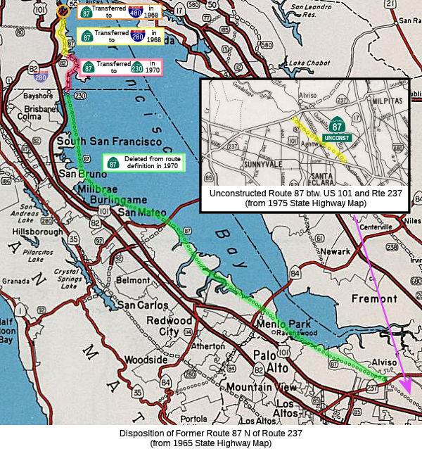 From San Jose easterly of Route 101 to Route 237.
Post 1964 Signage History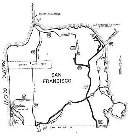
 In 1963, this segment was defined as “(b) San Jose easterly of the
Bayshore Freeway to Route 230.” There was also a segment (c),
defined as: “(c) Route 230 to Route 480 near the San
Francisco-Oakland Bay Bridge. Notwithstanding the provisions of Section 89
of Chapter 1062 of the Statutes of 1959, construction of all or any
portion of subdivision (c) of Route 87 may be commenced at any time, if
the City and County of San Francisco has conveyed or does convey to the
State of California, without charge, all real property presently acquired
by it for the construction of said subdivision (c) of this route or such
portion thereof.”
In 1963, this segment was defined as “(b) San Jose easterly of the
Bayshore Freeway to Route 230.” There was also a segment (c),
defined as: “(c) Route 230 to Route 480 near the San
Francisco-Oakland Bay Bridge. Notwithstanding the provisions of Section 89
of Chapter 1062 of the Statutes of 1959, construction of all or any
portion of subdivision (c) of Route 87 may be commenced at any time, if
the City and County of San Francisco has conveyed or does convey to the
State of California, without charge, all real property presently acquired
by it for the construction of said subdivision (c) of this route or such
portion thereof.”
![[480-87 Interchange, 1967 Conception, from Chris Sampang]](maps/1967-480.jpg) In 1968, Chapter 282 truncated segment (c) to be "Route 230 to Route 280 in San Francisco
In 1968, Chapter 282 truncated segment (c) to be "Route 230 to Route 280 in San Francisco Route 480 near the San
Francisco-Oakland Bay Bridge.” The deleted portion (Route 230 to Route 480) was transferred to I-80. This was part of the major
reworking of freeways in the San Francisco area due to the "Freeway
Revolt". Route 87 was originally planned as a full freeway in the ocean to
the E of US 101. In 1968, the portion from Route 280 to Route 480 [First
Street] was transferred to Route 280 (this was part of LRN 253). The image
to the right, from Chris Sampang's pages, illustrates this quite well.
In 1970, Chapter 1473 truncated segment (b) to terminate at Route 237 (instead of Route 230) and deleted (c). Former segment (c) was transferred to Route 230.
In 1980, Chapter 777 changed the wording of segment (b) to: “(b) San Jose easterly of Route 101 to Route 237.”
Pre 1964 Signage HistoryThis was LRN 289 (defined in 1959). The portion that was transferred to Route 280 and Route 230 was LRN 253.
 In January 1964, it was reported that (after a long
fight), the State Highway Commission adopted "Route C" for the Hunters
Point Freeway (LRN 289, future Route 87, later Route 230). Engineers had
proposed a shorter and $5 million cheaper route, but that route would have
uprooted hundreds of people in the Bay View District. It was noted that
the approved route runs for the most part through undeveloped and
industrial land, is 4.6 mi long, and will be a 4 and 6 lane highway, and
cost $49.8 million. It was never constructed.
In January 1964, it was reported that (after a long
fight), the State Highway Commission adopted "Route C" for the Hunters
Point Freeway (LRN 289, future Route 87, later Route 230). Engineers had
proposed a shorter and $5 million cheaper route, but that route would have
uprooted hundreds of people in the Bay View District. It was noted that
the approved route runs for the most part through undeveloped and
industrial land, is 4.6 mi long, and will be a 4 and 6 lane highway, and
cost $49.8 million. It was never constructed.
(Source: The San Francisco Examiner, 1/26/1964, via Joel Windmiller,
4/26/2023)
 In 1962, the CTC adopted the 3.4 mi segment between Evans
Avenue and the Embarcadero Freeway (Route 480). This portion was later
transferred to Route 280, although not all of it was constructed as
freeway.
In 1962, the CTC adopted the 3.4 mi segment between Evans
Avenue and the Embarcadero Freeway (Route 480). This portion was later
transferred to Route 280, although not all of it was constructed as
freeway.
(Source: Jan/Feb 1962 California Highways and Public Works)
Sign Route 87 was not defined in the initial set of state signed routes in 1934.
Status The 2013 Traversable Highways report notes that the route has not been adopted from Route 101 to Route 237. District 4 has not done any
study for future alignment of this route.
Naming Commuter Lanes
HOV lanes are planned for or constructed for this route as follows:
Status Part (2) is completely unconstructed. A route has not been adopted and there have been no studies for future alignment of this route.
Southbound HOV lanes from I-280 to Branham Lane began construction in Fall 2004. S/B direction. This project is being done by VTA. The project was completed in 2007.
In February 2012, there was an update on the project to construct high occupancy vehicle (HOV) lane and auxiliary lanes in each direction, construct 13 retaining walls and widen six bridges in San Jose, from 0.3 mile north of Branham Lane to 0.3 mile north of Virginia Street. Evidently, the project is overrunning its budget; the CTC authorized $6,200,000 in supplemental funding.
Pre 1964 Signage HistoryRoute 87 was not defined as part of the initial state signage of routes in 1934. It is unclear what (if any) route was signed as Route 87 between 1934 and 1964.
 Classified Landcaped Freeway
The following segments are designated as Classified Landscaped Freeway:
| County | Route | Starting PM | Ending PM |
| Santa Clara | 87 | 0.00 | 0.73 |
| Santa Clara | 87 | 4.86 | 6.25 |
| Santa Clara | 87 | 6.25 | 6.28 |
| Santa Clara | 87 | 6.51 | 6.90 |
 Freeway
[SHC 253.1] Entire route. The portion from Route 101 to Route 237 was added to the Freeway and Expressway system in 1959. The portion from Route 85 to Route 101 was added to the Freeway and Expressway system in 1961.
 Exit Information
 Other WWW Links
 Statistics
Overall statistics for Route 87:
 Pre-1964 Legislative Route
In 1933, three segments were added to the highway system: "[LRN 7] near Woodland to State Highway near Yuba City", "[LRN 15] near Marysville to [LRN 21] near Oroville", and "[LRN 3] near Chico to [LRN 21] near Oroville". In 1935, these were formally assigned to LRN 87, which was defined as:
In 1957, Chapter 36 extended the routing and combined two segments, giving:
This route was signed as follows:
This was signed as Alternate US 40. It is part of present-day Route 70, and portions are Route 113 and Route 99.
This connection was originally unsigned; it is present-day Route 149.
© 1996-2024 Daniel P. Faigin.
Maintained by: Daniel P. Faigin
<webmaster@cahighways.org>.
 Route 86
 Route 88