
 California Highways:
Click here for a key to the symbols used. An explanation of acronyms may be found at the bottom of the page.
 Routing
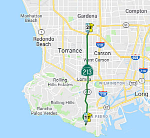 From 25th Street in San Pedro to
Route 405 via Western Avenue.
From 25th Street in San Pedro to
Route 405 via Western Avenue.
The commission may allocate from the State Highway Fund the necessary funds for the construction of all or any portion of said route when the County of Los Angeles and the Cities of Los Angeles and Torrance have entered into a co-operative agreement with the department wherein the said cities and county shall furnish to the state of California without charge all right-of-way necessary and agree to pay one-half the cost of plans and construction.
 Post 1964 Signage History
In 1963, this route was defined as "25th Street in San Pedro to Route 405 via Western Avenue." Later that year, Chapter 1729 added the condition: “The commission may allocate from the State Highway Fund the necessary funds for the construction of all or any portion of said route when the County of Los Angeles and the Cities of Los Angeles and Torrance have entered into a co-operative agreement with the department wherein the said cities and county shall furnish to the state of California without charge all right-of-way necessary and agree to pay one-half the cost of plans and construction.”
According to Scott Parker on AARoads: Route 213 was an undefined LRN corridor but without an adopted route. Actual adoption and signage
began in the '80's, at about the same time that Route 187 shields started
appearing on Venice Blvd. The actual Western Avenue adoption
occurred ca. 1984, at the behest of Union Oil, who have major refinery
facilities along its length and wanted to ensure state maintenance (some
county facilities bordering refinery perimeters in the area, particularly
in Carson and Harbor City, had long been deteriorating because of L.A.
County "deferred maintenance" policies of the time) of the major truck
access route. Also, Palos Verdes interests wanted to ensure the same
maintenance standards for the principal N-S corridor serving as a
connector to its eastern egress points (see the southern terminus picture
above). So Route 213 was formally adopted and has subsequently been
maintained for over three decades.
(Source: Scott Parker on AARoads, "Re: California SR 213 (Western Ave.)", 6/30/2020)
 Pre 1964 Signage History
This was LRN 291, defined in 1961 as "LRN 158 [I-405] near Western Avenue to 25th Street in San Pedro".
 Status
The traversable route from Carson St to I-405 is Western Avenue. There is a parallel unconstructed routing.
Complete Streets Project (07-LA-213 0.0/9.984)
In September 2021, it was reported that Caltrans is
planning a complete streets project on Route 213 – Western Avenue.
The project will be at various locations on the ~8-mile stretch of Western
Avenue between 25th Street (San Pedro, LA 0.0) and Carson Street
(Torrance/L.A. Harbor Gateway, LA 7.979) – in the cities of Lomita,
Los Angeles, Rancho Palos Verdes, and Torrance. Caltrans plans to add
sidewalks (where they are missing), Class 2 bike lane and Class 3 bike
routes, and enhanced crosswalks. Estimated cost is $1,529,000.
(Source: Streetsblog LA, 9/22/2021)
In December 2023, the CTC approved the following
amendment to a project in the 2022 SHOPP: 07-LA-213 0.0/9.984. PPNO
07-5371; ProjID 0718000076; EA 34660. Route 213 In and near the cities of
Los Angeles, Rancho Palos Verdes, Lomita, and Torrance, from West 25th
Street to Route 405. Rehabilitate pavement, upgrade guardrail, install
complete streets elements, including bike lanes and crosswalk
improvements, and upgrade facilities to Americans with
Disabilities Act (ADA) standards. Concurrent COS Supplemental allocation
under Resolution FA-23-47; December 2023. Note: Add complete streets
features to this project, including bike lanes, green pavement markings,
enhanced crosswalk markings, bicycle detection, and signal and sign
improvements. This additional need will be funded through
Infrastructure Investment and Jobs Act (IIJA) funds. Allocation Changes ($
× $1000): Con Sup $4,010 $4,828; R/W Cap $839
$999; Const Cap $20,060 $26,441; Total
$29,014 $36,373.
(Source: December 2023 CTC Agenda, Agenda Item 2.1a.(1d) #26)
In December 2023, the CTC considered a supplemental
allocation request for an additional $710,000 (78.0 percent increase) in
Pre-Construction Support, PA&ED phase, for07-LA-213 0/9.984; PPNO
07-5371; ProjID 0718000076; EA 34660. Route 213 In and near the cities of
Los Angeles, Rancho Palos Verdes, Lomita, and Torrance, from West 25th
Street to Route 405. Outcome/Output: Rehabilitate pavement, upgrade
guardrail, and upgrade facilities to Americans with Disabilities Act (ADA)
standards. Concurrent Amendment under SHOPP Amendment 22H-014; December
2023. The project realized cost increases due to the addition of scope to
incorporate complete streets elements to enhance bicycle and pedestrian
awareness and usage. This project was initially programmed to rehabilitate
the pavement, upgrade guardrail and curb ramps along a 10-mile segment of
Route 213. This project was selected to receive Infrastructure
Investment and Jobs Act funds to incorporate the following complete street
elements: • Class II/Class II buffered bicycle lanes; •
Conflict zone green paint; • Enhanced visibility painted crosswalks;
• Bicycle detection loops; • Bicycle boxes and two-stage left
turn queue boxes; • Bicycle and pedestrian signage. The project is
also adding approximately 1,100 feet of sidewalk, that will require
retaining walls for about 900 feet. Additional resources in the amount of
$710,000 will be required to incorporate these elements into the
environmental phase. The additional work includes field surveys,
geotechnical drilling and testing, retaining wall studies and type
selection, preparing preliminary plans, environmental studies, right of
way determination, and additional outreach efforts with local agencies and
communities. The Department anticipates completing the PA&ED
phase by June 2024, and requesting allocation for the PS&E and RW
Support phases in August 2024.
(Source: December 2023 CTC Agenda, Agenda Item 2.5e.(12))
Del Amo Intersection Left Turn Phasing (07-LA-213 9.1)
In October 2022, the CTC approved the following
pre-construction phase allocation: $463,000. 07-LA-213 9.1. PPNO 07-5870;
ProjID 0721000262; EA 38140. Route 213 In Torrance, at the intersection
with Del Amo Boulevard. Upgrade signals to include protected left turn
phasing and upgrade crosswalks and facilities to Americans with
Disabilities (ADA) standards. Allocation: FY 25-26 PA&ED $463,000.
Concurrent Amendment under SHOPP Amendment 22H-004; October 2022.
(Source: October 2022 CTC Agenda, Agenda Item 2.5b.(2a) #11)
 Other WWW Links
 Statistics
Overall statistics for Route 213:
 Pre-1964 Legislative Route
In 1947, Chapter 1370 added the route “to parallel approximately but not coincide with [LRN 4] near the northerly city limits of San Fernando to a point on said route near the southerly limits thereof”. The route was added with no number.
In 1949, Chapters 909 and 1467 deleted the 1947 definition of the route, and added the route to the highway code as LRN 213 as “from a point on [LRN 4] near the northerly limits of San Fernando to a point on [LRN 4] near the southerly limits of San Fernando, approximately paralleling but not coinciding with [LRN 4]”
In 1961, Chapter 1146 added the condition that LRN 213 would “cease to be a state highway when the commission relinquishes that portion of the present [LRN 4] in the City of San Fernando upon the relocation of [LRN 4] outside of the City of San Fernando”.
This route is no longer a state highway. It was Truman Street and San Fernando Road through the city of San Fernando, and corresponds to a one-way routing parallel to the LRN 4 routing on San Fernando Blvd (US 99). It is not presently in the state highway system. It was constructed in 1950.
© 1996-2020 Daniel P. Faigin.
Maintained by: Daniel P. Faigin
<webmaster@cahighways.org>.
 Route 212
 Route 214