
 California Highways:
Click here for a key to the symbols used. An explanation of acronyms may be found at the bottom of the page.
 Routing
 Post 1964 Signage History
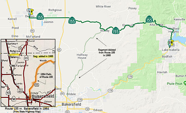
In 1963, Chapter 385 ("Great Renumbering") defined this route as "Route 99 near Bakersfield to Route 178 near Isabella via Glennville.", although Chapter 1698 quickly changed "Route 99" to "Route 204", reflecting the rerouting of Route 99 onto the freeway routing.
In 1965, Chapter 1372 realigned the route, deleting the portion from Route 204 to Woody, and tranferring the portion from Route 99 to Woody from Route 211, giving "Route 99 near Delano to Route 178 near Isabella via Glennville."
The following was noted by Scott Parker (SParker):
(Source: Scott Parker (SParker) on AARoads, "Re: Bitterwater Road, Old SSR 178, more LRN 137, and the 1914 Salinas River Bridge", 2/22/2017)
"There was never any field signage of the original Route 155 from Route 204 to the point where it was realigned toward Delano, which occurred in late 1966. Also involved in that process was the former Route 211, which headed east from Delano to the diagonal road that paralleled the (former) SP tracks northeast to Route 65 at Ducor. That diagonal alignment was the original Route 65 route, which diverged from US 99 near Famoso, where former US 466/present Route 46 intersects Route 99 today. In one fell swoop in 1966, Route 155 was commissioned from the turning point on Route 211 (which was never signed in the field) eastward on Garces Highway to the original Route 155 (former LRN 142) alignment, continuing northeast and east on the original alignment to the Lake Isabella area and its Route 178 terminus. The Route 211 designation was deleted from the books (but later re-used in Humboldt County). The portion of Route 155 from Bakersfield to the realignment point was subsequently relinquished."
 Pre 1964 Signage History
The original definition of this route was all of the original LRN 142, defined in 1933. See LRN 142 for the details of this version of the route. After 1965, a portion of LRN 136 (between Route 99 and the Famoso-Porterville Highway) was added. The remainder of this route (a direct route from the Famoso-Porterville Highway to Woody) was not defined before 1963.
Route 155 was not defined as part of the initial state signage of routes in 1934. It is unclear what (if any) route was signed as Route 155 between 1934 and 1964.
 Status
Browning Road Roundabout (06-Ker-155 ~ PM R1.46)
Caltrans is exploring creating a roundabout on this route at the intersection of Route 155/Browning Road in Delano (~ KER R1.47). Other potential/planned roundabout locations in the San Joaquin Valley include Route 145/Jensen near Kerman, Route 168/Auberry Road in Prather, Route 43/Route 137 in Corcoran, Route 216/Route 245 in Woodlake, Route 190/Road 284 east of Porterville, and Route 190/Road 152 east of Tipton. A 2007 study of 55 roundabouts in the U.S. found a 35% reduction in accidents and a 90% reduction in fatal accidents when intersections with stop signs or signals were converted to roundabouts. It costs about the same to build a roundabout as to put up traffic signals, and they need significantly less maintenance than traffic signal intersections -- about 60% to 90% less, depending on how much landscaping work is required.
In June 2020, the CTC authorized relinquishment of
right of way, consisting of collateral facilities, in the City of Delano,
Kern County, along Route 155 and Browning Road (06-Ker-155-PM R1.46). This
could be related to the Browning Road roundabout.
(Source: June 2020 CTC Agenda, Agenda Item 2.3c)
In December 2020, the CTC authorized relinquishment of
06-Ker-155-PM R1.46 (2 segments), right of way consisting of collateral
facilities, in the county of Kern along Route 155 on Browning Road. The
County agreed to waive the 90-day notice requirement and accept title upon
relinquishment by the State under the terms and conditions stated in the
relinquishment agreement dated September 17, 2020.
(Source: December 2020 CTC Agenda, Agenda Item
2.3c)
Alta Sierra Road Damage (06-Ker-155 42.0/R57.0)
In June 2023, it was reported that there was an
emergency allocation of $15,095,000 for 06-Ker-155 42.0/R57.0, PPNO
06-8047, ProjID 0623000200, EA 1G040. Route 155 Near Alta Sierra, from 0.3
mile west of Pascoe Road to 2.8 miles east of Alta Sierra Road. Storms in
February and March 2023 brought heavy rains that increased snow melt that
led to erosion of roads, shoulders, and slopes, landslides, and blocked
culverts. This project will remove debris, rebuild failed slopes with
retaining walls or geogrid, place slope protection, repair or replace
culverts, replace failed pavement, and replace traffic striping.
Allocation: CON ENG $1,500,000; CONST $13,595,000. Allocation date:
05/02/2023.
(Source: June 2023 CTC Agenda, Agenda Item 2.5f.(1) #46)
In August 2023, it was reported that Route 155 from
Alta Sierra east to Porterville is still under “local residents
only” restrictions in the damaged areas. CalTrans has partnered with
U.S. Forest Service and Kern County Roads to aid the general engineering
contractors, the Griffith Company out of Brea, California, and Genuine
Engineering from Corona, California, as both strive to get the road
repairs done safely and quickly. In early August 2023, CalTrans said they
were still confirming the repair sequence for Route 155 and are on track
for the repairs with Route 178. Both sections are extremely damaged, but
the state is looking for permanent repairs and not just a patch. With the
Kern River now more manageable due to more lake capacity and lower water
releases, the engineering team has a bigger area to safely work in.
(Source: Kern Valley Sun, 8/8/2023)
Note: There are extremely steep grades on the east end of this highway.
 National Trails
The segment of this route from Route 58 to Kernville via the Caliente-Bodfish Road) was historically named the "Lions Trail".
 Other WWW Links
 Statistics
Overall statistics for Route 155:
 Pre-1964 Legislative Route
In 1933, Chapter 767 added the routes from "[LRN 60] near Aliso Canyon to [LRN 2] near Triunfo" and "[LRN 2] near Newbury Park to [LRN 79] near Fillmore" to the state highway system. In 1935, these routes were added to the highway code as LRN 155, with the following definition:
This routing remained unchanged until 1963. It was all signed as part of Route 23, and included portions of Decker Canyon Road and Westlake Road.
© 1996-2020 Daniel P. Faigin.
Maintained by: Daniel P. Faigin
<webmaster@cahighways.org>.
 From Route
  Route 154
 Route 156