
Post 1964 Legislative Route 81
Click here for a key to the symbols used. An explanation of acronyms may be found at the bottom of the page.
 Routing
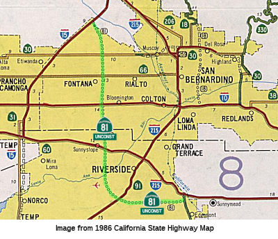 From Route 215 east of Riverside to Route 15 south of Devore.
 Post 1964 Signage History
In 1963, this route was defined to run from Route 395 east of Riverside
to Route 31 south of Devore.
In 1969, Chapter 294 changed "Route 395" to "Route 15".
In 1976, Chapter 1354 changed "Route 15" to "Route 194" and "Route 31" to
"Route 15".
In 1982, Chapter 681 changed "Route 194" to "Route 215".
 Pre 1964 Signage History
This routing was LRN 276, defined in 1959.The original definition of LRN 276 was as follows: "LRN 78 (US 395) east of Riverside to LRN 193 (Route 31) south of Devore.". The reference to Route 31 was, at the time, a long
offramp for future I-15 at the Devore I-15/I-215 split.
 Route 81 was not defined as part of the initial state signage of
routes in 1934. It is unclear what (if any) route was signed as Route 81
between 1934 and 1964. Based on research, it looks like the number was not
in use during that time as a signed route number.
Route 81 was not defined as part of the initial state signage of
routes in 1934. It is unclear what (if any) route was signed as Route 81
between 1934 and 1964. Based on research, it looks like the number was not
in use during that time as a signed route number.
 Status
It is unsigned, and no specific routing was ever determined. This was in the planning stages, but there are no local roads meeting the
definition of a traversable highway.
According to the 2013 Traversable Highways report, no local roads
adequately fit the description of a traversable highway. There are no
plans.
TEA-21 funded the reconstruction of the Route 81
(Sierra Avenue) and I-10 Interchange in Fontana. Although the legislation
noted that Sierra Avenue is Route 81, it is not signed as Route 81 and
doesn't appear to be formally part of the route.
 Freeway
[SHC 253.1] Entire route; unconstructed. Added to the Freeway and
Expressway system in 1959.
 Statistics
Overall statistics for Route 81:
- Total Length (1995): 31 miles unconstructed
- Mileage Classification: Urbanized: 31.
- Counties Traversed: Riverside, San Bernardino.
 Other WWW Links
 Pre-1964 Legislative Route
The route that would become LRN 81 was first defined in 1933 as the route
from "[LRN 71] to [LRN 1] N of Smith River", and was codified in 1935 into
the highway code as roughly that routing:
"[LRN 71] to [LRN 1], staying north of the Smith River"
This definition remained unchanged until the 1963 renumbering. This is
present-day Route 197 between US 101 and US 199.
Acronyms and Explanations:
- "LRN" refers to the Pre-1964 Legislative Route Number.
"US" refers to a US Shield signed route.
"I" refers to an Eisenhower Interstate signed route.
"Route" usually indicates a state shield signed route, but said route may be signed as US or I.
- Previous Federal Aid (pre-1992) categories:
Federal Aid Interstate (FAI); Federal Aid Primary (FAP);
Federal Aid Urban (FAU); and Federal Aid Secondary (FAS).
Current Functional Classifications (used for aid purposes):
Principal Arterial (PA); Minor Arterial (MA);
Collector (Col); Rural Minor Collector/Local Road (RMC/LR). Note that ISTEA repealed the previous Federal-Aid System, effective in 1992, and established the functional classification system for all public roads.
- Other frequently used terms: California Transportation Commission (Commission or CTC), California Department of Transportation (Department or Caltrans), Regional Improvement Program (RIP), Interregional Improvement Program (IIP), State Transportation Improvement Program (STIP), State Highway Operation and Protection Program (SHOPP), Traffic Congestion Relief Program (TCRP), Clean Air and Transportation Improvement Act of 1990 (Proposition 116), High Speed Passenger Train Bond Program (Proposition 1A), Highway Safety, Traffic Reduction, Air Quality, and Port Security Bond Act of 2006 (Proposition 1B), Corridor Mobility Improvement Account (CMIA), State Route 99 Bond Program (RTE or SR 99), Local Bridge Seismic Retrofit Account (LBSRA), Trade Corridors Improvement Fund (TCIF), Highway-Railroad Crossing Safety Account (HRCSA), State-Local Partnership Program (SLPP), Environmental Phase (PA&ED), Design Phase (PS&E), Right of Way (R/W), Fiscal Year (FY), Active Transportation Program (ATP), Trade Corridor Enhancement Program (TCEP), Local Partnership Program (LPP), Local Streets and Roads Program (LSRP), Solutions for Congested Corridors Program (SCCP).
 Route 80
 Route 82
© 1996-2020 Daniel P. Faigin.
Maintained by: Daniel P. Faigin
<webmaster@cahighways.org>.

 California Highways: