
 California Highways:
Click here for a key to the symbols used. An explanation of acronyms may be found at the bottom of the page.
 Routing
 Post 1964 Signage History
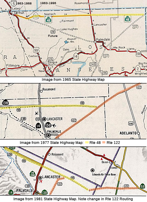
As defined in 1963, Route 48 was the route from Route 138 near Gorman to Route 122 near the San Bernardino county line. This was the existing signed Route 138 alignment to Route 14, and a new alignment from Route 14 to Route 122.
The 1963 alignment arose because Route 138 was legislatively realigned to
run along a new alignment along what is modern Los Angeles County Sign Route N2 from
Route 138 at Quail Lake southeast to Palmdale, in preparation for the
Metropolitan Bypass, which would have run directly to the segment of Route 138 E of Route 14. As such, Route 138/LRN 59 from Quail Lake east to US 6/LRN 23 was given a new LRN 267 designation. During the 1964 Highway
renumbering the proposed route of LRN 59 between Quail Lake and Palmdale
was assigned to Route 138. LRN 267 to the north was assigned as part of
Route 48. By 1967, the path of Route 138 was eventually moved to a new
freeway/expressway alignment which bypassed the Old Ridge Route alignment
on Gorman Post Road. Eventually there were plans to route Route 138 along
Signed County Route N2
(Based on: Gribblenation Blog - California State Route 138)
In 1968, Chapter 282 changed the origin of the route to be "Route 138 east of Gorman".
Although not indicated from the route definition, a redefinition of Route 122 in 1976 created a discontinuity in Route 122 at the point it met Route 48. This essentially extended Route 48 without changing the definition.
 In 1977, the CHC published that it was considering unadoption of the 15.3 mi
segment of the adopted freeway corridor on Route 48, the "Lancaster
Freeway", from adopted Route 138 to Route 14. This corridor was adopted in
1962.
In 1977, the CHC published that it was considering unadoption of the 15.3 mi
segment of the adopted freeway corridor on Route 48, the "Lancaster
Freeway", from adopted Route 138 to Route 14. This corridor was adopted in
1962.
(Source: Published Announcement, 1977, via Joel Windmiller,
2/25/2023)
In 1996, Chapter 10 truncated the origin even further, beginning the route at "Route 14 near Lancaster". The portion from Route 138 to Route 14 was transferred to Route 138. This just left the unconstructed portion.
A 1965 planning map shows that this was to have been freeway; never upgraded.
 Pre 1964 Signage History
 This segment was LRN 267 (defined in 1959), and was unconstructed
before 1964. Prior to 1964, this segment was signed as part of Route 138,
and constituted the constructed portion for LRN 59, established in the
1919 Third Bond Act (Lancaster to Baileys). In 1959, LRN 59 was rerouted
to the new Metropolitan Bypass routing through Lake Hughes, and the older
routing was renumbered as LRN 267.
This segment was LRN 267 (defined in 1959), and was unconstructed
before 1964. Prior to 1964, this segment was signed as part of Route 138,
and constituted the constructed portion for LRN 59, established in the
1919 Third Bond Act (Lancaster to Baileys). In 1959, LRN 59 was rerouted
to the new Metropolitan Bypass routing through Lake Hughes, and the older
routing was renumbered as LRN 267.
 In 1921, Chapter 841 authorized the Department of Engineering “...to make an investigation and submit a preliminary report upon a
proposed state road with the necessary bridges connecting the city of
Vallejo with a point on the state highway near Sears Point in Sonoma
County... Beginning at the intersection of Butte and Tennessee Streets in
Vallejo, and running thence N-ly along Wilson Avenue to the limits of said
city, thence continuing along the paved county roads through the Bay
terrace district to a point in the vicinity of the lands formerly owned by
Vallejo Brick and Tile Company, thence leaving the mainland and running
W-ly across the Napa river to island number one: situated on the immediate
W bank of the Napa river and immediately N of Marc island and adjacent to
the E short of San Pablo bay; thence NW-ly along said San Pablo shore
levee to a point near the mouth of Sonoma creek and running W-ly across
Tubbs island and across Tolay creek to a junction with the state highway
in the vicinity of Sears point.” It appears that this highway was
not added to the state highway system at this time.
In 1921, Chapter 841 authorized the Department of Engineering “...to make an investigation and submit a preliminary report upon a
proposed state road with the necessary bridges connecting the city of
Vallejo with a point on the state highway near Sears Point in Sonoma
County... Beginning at the intersection of Butte and Tennessee Streets in
Vallejo, and running thence N-ly along Wilson Avenue to the limits of said
city, thence continuing along the paved county roads through the Bay
terrace district to a point in the vicinity of the lands formerly owned by
Vallejo Brick and Tile Company, thence leaving the mainland and running
W-ly across the Napa river to island number one: situated on the immediate
W bank of the Napa river and immediately N of Marc island and adjacent to
the E short of San Pablo bay; thence NW-ly along said San Pablo shore
levee to a point near the mouth of Sonoma creek and running W-ly across
Tubbs island and across Tolay creek to a junction with the state highway
in the vicinity of Sears point.” It appears that this highway was
not added to the state highway system at this time.
In 1939, Chapter 473 defined LRN 208 as the route from "[LRN 8] near Sears Point to [LRN 7] near Lake Chabot." This route was signed as Route 48. It ran from Route 37 near Sears Point to US 40 (present-day I-80) near Lake Chabot.
In the "great renumbering", Route 48 was subsumed into present-day Route 37.
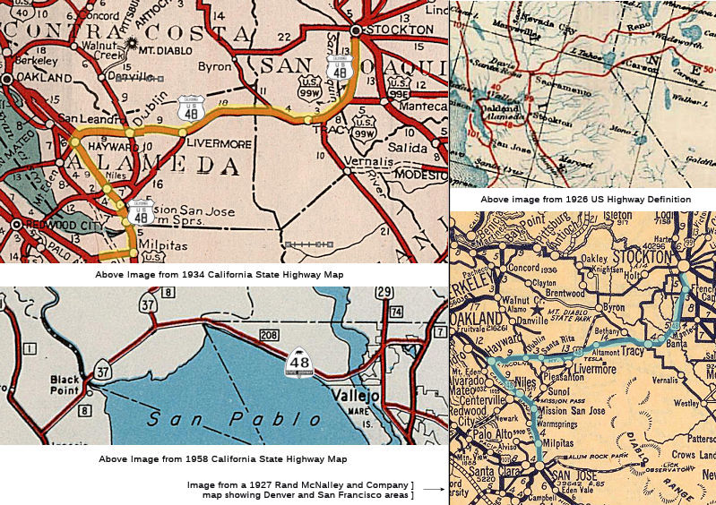
 US 48 was on the original map of US routes in 1926, running from Stockton to
Oakland and San Jose (although at one time it was shown as US 42), along
what is nowadays I-580 and US 101E/I-880. In 1928, US 48 was signed in
California. It ran from French Camp to San Jose via Tracy and Hayward
(shown on this 1927 map). By 1935, this had been renumbered as part of US-50 (LRN 5)
using a routing that is now I-580 and I-205 (from Oakland along I-580
until the I-205/I-580 junction, and then along I-205 to Tracy; however,
there are some reports that include I-238 in Oakland as part of the
original US 48, and that indicate it was numbered as US 101E. There are
also some maps that show Route 237 as part of US 48 (nee US 42).
US 48 was on the original map of US routes in 1926, running from Stockton to
Oakland and San Jose (although at one time it was shown as US 42), along
what is nowadays I-580 and US 101E/I-880. In 1928, US 48 was signed in
California. It ran from French Camp to San Jose via Tracy and Hayward
(shown on this 1927 map). By 1935, this had been renumbered as part of US-50 (LRN 5)
using a routing that is now I-580 and I-205 (from Oakland along I-580
until the I-205/I-580 junction, and then along I-205 to Tracy; however,
there are some reports that include I-238 in Oakland as part of the
original US 48, and that indicate it was numbered as US 101E. There are
also some maps that show Route 237 as part of US 48 (nee US 42).
 Tom Fearer notes the following regarding US 48:
(Source: Gribblenation Blog: Hunting the early Lincoln Highway and US Route 48 from French Camp west of Altamont Pass)
In October of 1913 the Lincoln Highway was formally dedicated. The Lincoln Highway was routed from French Camp over Altamont Pass on the following alignment:
- Ash Street to Harlan Road.
- Harlan Road through Lathrop to Manthey Road
- An older crossing via Manthey Road through Mossdale which is up river south of the current roadway.
- Manthey Road through the present right of way of I-5 to 11th Street/I-205 BL.
- 11th Street to Grant Line Road/County Sign Route J4.
- Grant Line Road/County Sign Route J4 to Banta via G Street.
- Likely 7th Street and F Street through Banta.
- F Street to Banta Road.
- Banta Road to 11th Street.
- 11th Street to Byron Road.
- Byron Road (which becomes County Sign Route J4 north of I-205) to Grant Line Road
- Grant Line Road to Altamont Pass Road
- Altamont Pass Road over Altamont Pass
The Lincoln Highway appears to have been shifted out of Banta by 1918 onto the 11th Street Bypass which can be seen on the State Highway Map of the same year. The route of US 48 was ultimately selected to be routed from French Camp west over Altamont Pass and by proxy San Jose in 1926. US 48 was largely planned to originate at US 99 in French Camp and travel southwest by way of Altamont Pass to San Jose. US 48 ultimately appears between French Camp and San Jose on 1926/1927 commercial maps. In 1928 State Maintenance of LRN 4 out of Stockton shifted to Mariposa Road. This eventually led to a request by the State of California to the AASHO to extend the east terminus of US 48 to Stockton and create a US 48N to Oakland. The request was for US 48 was borne out of US 99 moving out of French Camp to a direct alignment between Stockton-Manteca. The AASHO rejected this concept but offered an alternative which truncated US 48 from San Jose to Hayward and from French Camp to Mossdale. This alternative conceptualized US 101E and the US 99W/US 99E split from Stockton-Manteca. The truncation of US 48, creation of US 101E, and the US 99W/US 99E Stockton-Manteca split was approved in April of 1929 by the AASHO. The State of California made a request to the AASHO to extend US 50 from Stockton to Oakland in 1931. The AASHO approved US 50 to subsume all of remaining US 48 by June of said year. The State of California would not attempt to resolve US 101E and the US 99W/US 99E Stockton-Manteca split by pursuing deletion of those routes until 1932.
West of Livermore, US 48 (LRN 5) continued through Dublin, the Castro
Valley, and Hayward, and continued S to San Jose via Mission Blvd. The
original plan (proposed in 1910) was to route LRN 5 along Castro Valley
Road/Mattox Road, but the decision was made to use a route through
Hayward. The first generation of LRN 5 was along East Castro Valley (the
old version of Dublin Road, now abandoned) through Castro Valley, and on
to Hayward via Grove and A Street. In 1926, LRN 5 became US 48, and in
1930, the state rerouted LRN 5 via Castro Valley Blvd/Mattox Road,
bypassing Hayward and building a high-speed connector to Foothill Blvd. It
was at this time that Maddox Road was widened to 100'. In 1933, the route
was renumbered as part of US 50. It appears the US 48 routing was Dublin
Road (Dublin Blvd) to Castro Valley Road, to Foothill Blvd, and then S on
Mission Blvd. In 1930, with the renumbering to US 50, the routing changed
to run N to Oakland.
(Source: Email from Rick Kelley, 2/23/2021)
Note that US 48 was originally proposed as US 42, but the number was changed to US 48 in 1926.
 Status
 This route is unconstructed from Route 14 to future Route 122.
There is no paved traversable local highway. For information on the High
Desert
Corridor, see Route 138.
The 2013 Traversable Highways report notes that there is no paved traversable highway.
 Note: There is seemingly a Route 48 route marker postmile at the Calaveras-Tuolomne county line on
O’Byrne’s Ferry Road between Route 108 and Route 4 near
Copperopolis. It is just past the bridge that carries the road over the
Stanislaus River. Currently this road is signed as Calaveras County Sign Route E15. The
key word is "seemingly", because investigation determined that this is a
Calaveras county road marker: The CAL in this case represents
the first 3 letters of the County, Calaveras. The 48 is the county road
number. Each County-maintained road is assigned a number; they have other
similar markers on roads in the County-maintained system. The problem is
that this is almost identical to a post mile for Route 48 if Route 48 was
in Calaveras County.
Note: There is seemingly a Route 48 route marker postmile at the Calaveras-Tuolomne county line on
O’Byrne’s Ferry Road between Route 108 and Route 4 near
Copperopolis. It is just past the bridge that carries the road over the
Stanislaus River. Currently this road is signed as Calaveras County Sign Route E15. The
key word is "seemingly", because investigation determined that this is a
Calaveras county road marker: The CAL in this case represents
the first 3 letters of the County, Calaveras. The 48 is the county road
number. Each County-maintained road is assigned a number; they have other
similar markers on roads in the County-maintained system. The problem is
that this is almost identical to a post mile for Route 48 if Route 48 was
in Calaveras County.
 Freeway
[SHC 253.1] Entire route. Added to the Freeway and Expressway system in 1959.
 Statistics
Overall statistics for Route 48:
 National Trails
 US 48 was part of the coast-to-coast "Lincoln Highway"
between the Nevada border and the junction with US 40 into San Francisco.
The Lincoln Highway presently would encompass not only US 50, but a
portion of I-5 and a portion of I-580.
 Other WWW Links
 Pre-1964 Legislative Route
The route that would become LRN 48 was first defined in the 1919 Third Bond Act as running from McDonalds to the mouth of the Navarro River. This was captured in the 1935 highway code as:
[LRN 1] at McDonald's to the mouth of the Navarro River
It was amended later that year by Chapter 274 to begin at "[LRN 1] near Cloverdale via McDonald's"
In 1963, Chapter 1698 would have removed the "via McDonald's", but that was overtaken by the 1963 renumbering.
This route was signed as Route 128.
© 1996-2020 Daniel P. Faigin.
Maintained by: Daniel P. Faigin
<webmaster@cahighways.org>.
 From Route
  Route 47
 Route 49