
 California Highways:
[Click here for a key to the symbols used. Some county routes were constructed with federal funds. These routes are indicated as FAP (Federal Aid Primary), FAU (Federal Aid Urban), or FAS (Federal Aid Secondary). If no funding source is shown, no federal funds were used. Note that while some segments seem to have the same attributes, they may differ in the county-local road number assigned to the segment, or in the Caltrans Map Sheet number.]
 Routing
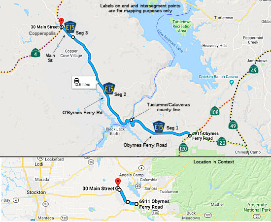 O'Byrnes Ferry Road from Route 120 near Yosemite Junction to the Calaveras county
line (FAS, 4.85 mi) [Tuolumne County]
O'Byrnes Ferry Road from Route 120 near Yosemite Junction to the Calaveras county
line (FAS, 4.85 mi) [Tuolumne County]
O'Byrnes Ferry Road from the Tuolumne county line to Reeds Turnpike (FAS, 7.47 mi) [Calaveras County]
Main Street from Reeds Turnpike to Route 4 in Copperopolis (FAS, 0.59 mi)
 History and Signage Information
This route was defined in 1974.
O’Byrne’s Ferry Bridge started out as a simple old toll
bridge between two counties. Patrick O. Byrne started construction of a
chain cable bridge in 1852 across the Stanislaus River on the line between
Calaveras and Tuolumne counties. It soon became a bustling toll bridge
since it was on the primary road between Stockton and Sonora.
Unfortunately, the bridge had a short first life. Heavy rain weakened the
structure and one of the chains gave way as a six-ox team and two men were
crossing it! The men were able to swim to safety, but the oxen and wagon
were swept away. The bridge was mended and continued to serve as a toll
bridge for years until the devastating flood of 1862 washed it away along
with almost every bridge on the rivers in the Sierra foothills. There are
conflicting accounts about whether or not the bridge was ever restored
after its first incident. Some say a ferry served those wishing to cross
until the Union Bridge was built in 1862, while others say it was restored
right away. Either way, the bridge sustained as a toll bridge until 1902
when it was purchased by the neighboring counties; Calaveras and Tuolumne
for $4000. A local cattleman convinced the counties to split the cost and
make it a free bridge for the reason that he disapproved of paying the
toll when the bridge was in poor condition and was dangerous for horses.
Decades later, the Tri-Dam Project was approved which meant that the
creation of the Tulloch Reservoir would drown the bridge. Numerous
historical groups, as well as the general public, were concerned for the
demise of the bridge and wanted to preserve it somehow. Many plans were
drawn up, some wanted to float it and turn it into a tourist stop but
unfortunately, time was not on their side. The Irrigation Districts had
closed the flood gates and the water was rising fast! After much effort
and even the use of dynamite, the bridge was eventually detached from the
shores and made a splash as is was drug to its final resting place. Locals
began scavenging for nails, washers and even wood planks to take as
souvenirs. Slowly, day by day, workers took apart what was left of the
bridge and it was sold to various parties planning on using parts at other
recreational areas around the reservoir.
(Source: Sierra Nevada Tourism, "O'Byrne's Ferry Bridge (№ 281 California Historical Landmark)", 3/2/2026)
The O'Byrne Ferry Covered Bridge was removed during 1955 as part of the
Tri-Dam Project which eventually formed Lake Tulloch. O'Byrne's
Ferry Road was subsequently realigned via a bridge that crossed the
Tuolumne/Calaveras County line at the site of Lake Tulloch. The
current O'Byrne's Ferry historical plaque was placed by the Calaveras
County Historical Society during 1993 along County Sign Route E15.
(Source: Gribblenation Blog (Tom Fearer): "O'Bryne's Ferry Covered Bridge", 7/19/2023)
 Other WWW Links
 Status
 Unsigned along the route. There is a sign directing traffic to E15 from Route 108/Route 120, and another E15 sign at the Tuolumne/Calaveras
county border. Total mileage: 12.91 mi.
Unsigned along the route. There is a sign directing traffic to E15 from Route 108/Route 120, and another E15 sign at the Tuolumne/Calaveras
county border. Total mileage: 12.91 mi.
© 1996-2024 Daniel P. Faigin.
Maintained by: Daniel P. Faigin
<webmaster@cahighways.org>.
 CR E14
 CR E16