
 California Highways:
[Click here for a key to the symbols used. Some county routes were constructed with federal funds. These routes are indicated as FAP (Federal Aid Primary), FAU (Federal Aid Urban), or FAS (Federal Aid Secondary). If no funding source is shown, no federal funds were used. Note that while some segments seem to have the same attributes, they may differ in the county-local road number assigned to the segment, or in the Caltrans Map Sheet number.]
 Routing
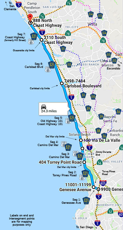 Genesee Avenue in San Diego from I-5 to N Torrey Pines Road (FAU, 0.80 mi)
 Torrey Pines Road from Genesee Avenue to the Del Mar city limits (FAU, 3.98 mi)
Camino Del Mar in Del Mar from the Del Mar city limits to Jimmy Durante Blvd (FAU, 1.84 mi)
Camino Del Mar in Del Mar from Jimmy Durante Blvd to the Del Mar city limits (1.00 mi)
Old Highway 101 / Coast Highway 101 from the Del Mar city limits to the Carlsbad city limits (FAU, 8.10 mi)
 Status
In February 2017, it was reported that there is a growing movement to
transform former US 101 (Coast Highway) in North San Diego County into
something more bicycle and pedestrian friendly. From Del Mar to Oceanside,
cities are looking to slow traffic, widen bike lanes and implement other
changes that encourage people to get out of their cars and use alternate
forms of transportation. Solana Beach finished an overhaul its portion of
Coast Highway in 2013, completing a $7 million project that converted the
road to narrower lanes with wide sidewalks, gathering spaces and buffered
bike lanes. Encinitas made changes in Leucadia, reducing traffic lanes and
adding “sharrows” — large white markers painted on the
asphalt — to remind drivers to slow down and share the lane. Del Mar
and Oceanside are studying similar changes, hoping to better accommodate
bicyclists and pedestrians and create a more vibrant environment for
businesses and residents along the coast. However, there are (as they say)
bumps in the road. After a re-striping pilot program was launched in 2016
in Oceanside — reducing parts of Coast Highway from two to four
lanes, and adding wider bike lanes — more than 400 people signed a
petition against the changes. Del Mar is another town where the idea has
run into trouble. City planners have proposed reducing northbound Camino
del Mar — the name for Coast Highway in that city — from two
lanes to one between Carmel Valley Road and Fourth Street. That prompted a
letter-writing campaign from residents early this year. A few supported
the plan, but most said the narrower road would worsen congestion and
force more traffic onto the parallel residential street of Stratford
Court. A back-up freeway isn’t the vision that many city planners
have for the historic road. Instead of escorting drivers out of town, they
see the coastal route as a way to invite people in, to stop and shop, ride
bicycles, enjoy the beach, and maybe meet some new people or old friends.
Leaders of the region’s robust cycling community say slowing traffic
and improving bike lanes along former US 101 will ultimately improve the
quality of life for all.
(Source: San Diego U-T, 2/17/2017)
In November 2020, it was reported that Carlsbad Boulevard, the nearly
seven-mile stretch of road also known as Old Highway 101 through Carlsbad,
is about to get a third designation — U.S. Bicycle Route 95.
The recognition would make Carlsbad Boulevard part of a national network
of routes intended to facilitate interstate travel by bicycle on roads and
highways identified as suitable for cycling. Carlsbad will be the last
city in San Diego County to approve the designation. About 75 percent of
the 1,000-mile route has been established from the California-Oregon
border to the U.S. border with Mexico. Eventually, plans call for U.S.
Bicycle Route 95 to extend to the Canadian border. East-West routes
in the works include U.S. Bicycle Route 50 from San Francisco
through South Lake Tahoe and on through Nevada and Utah, and Bicycle
Route 66, which goes from Los Angeles through parts of Arizona and
New Mexico. The American Association of State Highways and Transportation
Officials created the U.S. Bicycle Route System in the early 1980s. So far
there are designated bicycle routes in 24 states, used for cross-country
travel, regional touring and commuting. Cities that agree to the
designation are not required to take any additional action. No additional
route markings, such as signs or bike lane markings, are required. More
information on the U.S. Bicycle Route system may be found at the Adventure Cycling Association, Caltrans,
(Source: San Diego Union Tribune, 11/16/2020)
In April 2024, it was reported that the city of Carlsbad's Beach
Preservation Commission voted unanimously to recommend realigning a
one-mile stretch of the coastal former US 101, also known as Carlsbad
Boulevard (County Sign Route S21), in an all-encompassing approach referred to as
“retreat now.” The alternative would have been a phased
approach where changes would be made to the impacted roadway, which runs
from Manzano Drive in the north to Island Way in the south, incrementally
over a 96-year period. The southern tip of former US 101 has a long
history of erosion and instability, particularly near Las Encinas Creek.
City officials say events like high surf or coastal storms have often
rendered the roadway inaccessible due to flooding. Carlsbad officials have
looked to solve this coastal overflow by doing emergency work under
temporary permits from the state’s Coastal Commission, such as
extending the rock barriers that line the roadway — a step the city
has taken at least twice since 2015. As a condition of these temporary
permits, however, the state instructed Carlsbad to seek a more permanent
solution. That’s where the realignment project comes in. According
to city documents, the realignment project includes two main components: a
guide for how the road could be moved from the coastline, and an adaptive
management plan to put those changes into motion. Four segments of the
southbound side of the roadway — including biking and walking paths
— will be re-routed into a two-lane street with several roundabouts.
The project would also allow for habitat restoration along the roadway in
the areas where the southbound plan is currently routed.
(Source: Fox 5 San Diego, 4/8/2024)
Carlsbad Blvd in Carlsbad from the Carlsbad city limits to the Oceanside city limits (FAU, 6.17 mi)
Coast Highway (formerly Hill Street) in Oceanside from the Oceanside city limits to I-5 (FAU, 2.85 mi)
 History and Signage Information
 This route was defined in 1968. Portions of this route are the former routing of US 101. Portions are the former Carlsbad Freeway, built
between 1950 and 1953. specifically, the portion between La Costa and
Palomar Airport Road. There was also a Business US 101 in this area.
StatusSome of the S-21 shields along old US 101 have been painted over with the California Poppy.
 In September 2009, it was reported that the Encinas Creek
bridge was to be replaced in January 2010. Built in 1913, the Encinas
Creek Bridge handles southbound traffic along Carlsbad Boulevard and is
located about a half mile south of the Palomar Airport Road intersection.
The bridge has low, concrete railings and a graceful, arched look. The
bridge's exposed reinforcing bars have become "heavily corroded," and one
of its two lanes ---- the western one ---- was shut down more than a year
ago after the bridge failed a state Department of Transportation safety
inspection. Plans call for the bridge to be replaced with a span that's 26
feet narrower, but 15 feet longer and two feet higher. The new span will
be built off-site and trucked to the area to reduce the amount of time
that Carlsbad Boulevard will be closed.
In September 2009, it was reported that the Encinas Creek
bridge was to be replaced in January 2010. Built in 1913, the Encinas
Creek Bridge handles southbound traffic along Carlsbad Boulevard and is
located about a half mile south of the Palomar Airport Road intersection.
The bridge has low, concrete railings and a graceful, arched look. The
bridge's exposed reinforcing bars have become "heavily corroded," and one
of its two lanes ---- the western one ---- was shut down more than a year
ago after the bridge failed a state Department of Transportation safety
inspection. Plans call for the bridge to be replaced with a span that's 26
feet narrower, but 15 feet longer and two feet higher. The new span will
be built off-site and trucked to the area to reduce the amount of time
that Carlsbad Boulevard will be closed.
[Based on an article in the North County Times, "CARLSBAD: City to take out Encinas Creek bridge starting in January", 2009-08-31]
 Total mileage: 24.74 mi. At one time, the entire route was designated as Business Route 5; presently, only the old Highway 101 portion is Business Route 5.
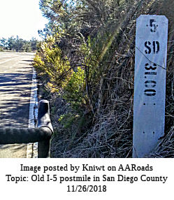
There are a few postmiles dating from the post-1964 renumbering showing
the route as Route 5 (from when US 101 had been renumbered as Future I-5,
but I-5 was still under-construction. The picture to the right was posted
on AAroads by Kniwt.
Total mileage: 24.74 mi. At one time, the entire route was designated as Business Route 5; presently, only the old Highway 101 portion is Business Route 5.
There are a few postmiles dating from the post-1964 renumbering showing
the route as Route 5 (from when US 101 had been renumbered as Future I-5,
but I-5 was still under-construction. The picture to the right was posted
on AAroads by Kniwt.
 Other WWW Links
© 1996-2024 Daniel P. Faigin.
Maintained by: Daniel P. Faigin
<webmaster@cahighways.org>.
 CR S20
 CR S22