
 California Highways:
[Click here for a key to the symbols used. Some county routes were constructed with federal funds. These routes are indicated as FAP (Federal Aid Primary), FAU (Federal Aid Urban), or FAS (Federal Aid Secondary). If no funding source is shown, no federal funds were used. Note that while some segments seem to have the same attributes, they may differ in the county-local road number assigned to the segment, or in the Caltrans Map Sheet number.]
 Routing
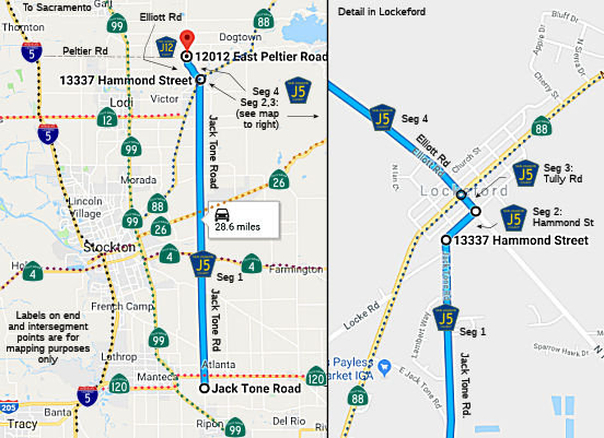 Jack Tone Road from Route 99 near Ripon to Hammond Street (FAS, 28.13 mi)
Note: It appears that at some time between 1960 and 1972, a bypass was constructed by the county just S of Lockeford. This bypass curves away from Jack Tone Road N of Dawson Road to end at Route 12/Route 88. Open Street Maps shows County Sign Route J5 curving off Jack Tone Road onto the bypass road; Google Maps shows County Sign Route J5 continuing on Jack Tone Road.
Hammond St from Jack Tone Road to Tully Road (FAS, 0.06 mi)
Note: This segment may have been replaced with construction of the Jack Tone Bypass Road. Open Street Maps show County Sign Route J5 running along the Jack Tone Bypass Road from Jack Tone Road to Route 88 (0.30 mi). Google Maps, however, still shows the routing continuing on Jack Tone Road to Hammond Street, and then continuing along Hammond Street. As the route is likely unsigned, the correct routing is hard to determine.
Tully Road from Hammond Street to Route 88 near Lockeford (FAS, 0.06 mi)
Note: This segment may have been replaced with construction of the Jack Tone Bypass. Open Street Maps shows County Sign Route J5 running along Route 88/Route 12 from the Jack Tone Bypass to Elliott Road (0.5 mi). Google Maps still shows the original routing along Jack Tone Road, Hammond Street, and Tully Road to Route 88/Route 12.
Elliot Road from Route 88 to Peltier Road (County Sign Route J12) (FAS, 2.20 mi)
 History and Signage Information
This route was defined in 1960.
 Status
Total mileage: 30.45 mi.
© 1996-2024 Daniel P. Faigin.
Maintained by: Daniel P. Faigin
<webmaster@cahighways.org>.
 CR J4
CR J4 CR J6
CR J6