
Imperial
County Sign Route S26
[Click here for a key to the symbols used.
Some county routes were constructed with federal funds.
These routes are indicated as FAP (Federal Aid Primary), FAU (Federal Aid Urban), or FAS (Federal Aid Secondary).
If no funding source is shown, no federal funds were used.
Note that while some segments seem to have the same attributes,
they may differ in the county-local road number assigned to the segment,
or in the Caltrans Map Sheet number.]
 Routing
-
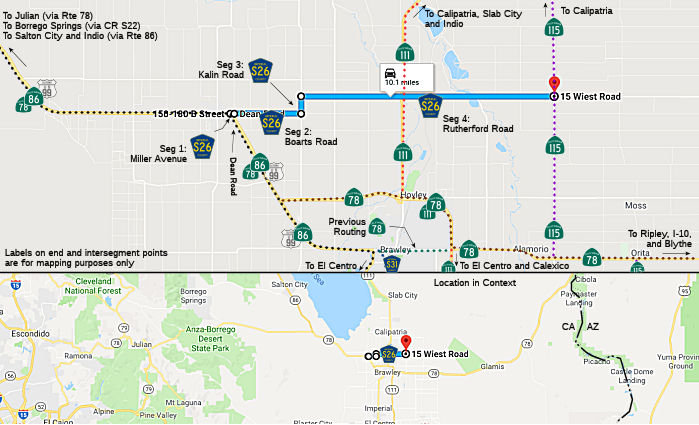 Miller Avenue in Westmoreland from Route 86 to Dean Road (FAS, 0.21 mi)
-
Boarts Road from Dean Road to Kalin Road (FAS, 1.99 mi)
-
Kalin Road from Boarts Road to Rutherford Road (FAS, 0.50 mi)
-
Rutherford Road from Kalin Road to Route 115 (FAS, 7.50 mi)
 History and Signage Information
This route was defined in 1970.
 Status
There is no indication anywhere around the western terminus of the road,
either within the City of Westmoreland or on County land immediately east
of the city limits, and even on the Route 78/Route 86 expressway, that County Sign Route S26 exists. There is no ‘END’ shield on Miller/Boarts.
(Source: Adrian Ople in private email, 8/21/2026)
Total mileage: 10.20 mi.
Acronyms and Explanations:
- "LRN" refers to the Pre-1964 Legislative Route Number.
"US" refers to a US Shield signed route.
"I" refers to an Eisenhower Interstate signed route.
"Route" usually indicates a state shield signed route, but said route may be signed as US or I.
- Previous Federal Aid (pre-1992) categories:
Federal Aid Interstate (FAI); Federal Aid Primary (FAP);
Federal Aid Urban (FAU); and Federal Aid Secondary (FAS).
Current Functional Classifications (used for aid purposes):
Principal Arterial (PA); Minor Arterial (MA);
Collector (Col); Rural Minor Collector/Local Road (RMC/LR). Note that ISTEA repealed the previous Federal-Aid System, effective in 1992, and established the functional classification system for all public roads.
- Other frequently used terms: California Transportation Commission (Commission or CTC), California Department of Transportation (Department or Caltrans), Regional Improvement Program (RIP), Interregional Improvement Program (IIP), State Transportation Improvement Program (STIP), State Highway Operation and Protection Program (SHOPP), Traffic Congestion Relief Program (TCRP), Clean Air and Transportation Improvement Act of 1990 (Proposition 116), High Speed Passenger Train Bond Program (Proposition 1A), Highway Safety, Traffic Reduction, Air Quality, and Port Security Bond Act of 2006 (Proposition 1B), Corridor Mobility Improvement Account (CMIA), State Route 99 Bond Program (RTE or SR 99), Local Bridge Seismic Retrofit Account (LBSRA), Trade Corridors Improvement Fund (TCIF), Highway-Railroad Crossing Safety Account (HRCSA), State-Local Partnership Program (SLPP), Environmental Phase (PA&ED), Design Phase (PS&E), Right of Way (R/W), Fiscal Year (FY), Active Transportation Program (ATP), Trade Corridor Enhancement Program (TCEP), Local Partnership Program (LPP), Local Streets and Roads Program (LSRP), Solutions for Congested Corridors Program (SCCP).
 CR S25
 CR S27
© 1996-2024 Daniel P. Faigin.
Maintained by: Daniel P. Faigin
<webmaster@cahighways.org>.

 California Highways: