
 California Highways:
[Click here for a key to the symbols used. Some county routes were constructed with federal funds. These routes are indicated as FAP (Federal Aid Primary), FAU (Federal Aid Urban), or FAS (Federal Aid Secondary). If no funding source is shown, no federal funds were used. Note that while some segments seem to have the same attributes, they may differ in the county-local road number assigned to the segment, or in the Caltrans Map Sheet number.]
 Routing
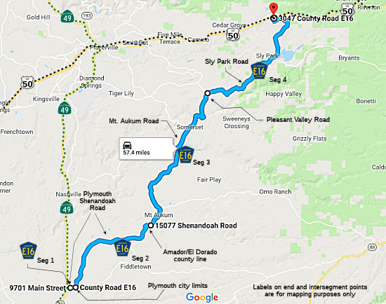 Plymouth Shenandoah Road in Plymouth from Route 49 to the Plymouth city limits
(FAS, 0.15 mi) [Amador County]
Plymouth Shenandoah Road in Plymouth from Route 49 to the Plymouth city limits
(FAS, 0.15 mi) [Amador County]
Plymouth Shenandoah Road from the Plymouth city limits to the El Dorado county line (FAS, 9.08 mi) [Amador County]
Mt. Aukum Road from the Amador county line to Pleasant Valley Road (FAS, 12.58 mi) [El Dorado County]
Sly Park Road from Pleasant Valley Road to US 50 near Fresh Pond (FAS, 11.40 mi) [El Dorado County]
 History and Signage Information
This route was defined in 1967.
The corridor functionally acts as a continuation of Route 16 east of the
Plymouth area (Route 16 meets Route 49 near Drytown, and then Route 49
continues NNE to Plymouth, where County Sign Route E16 starts). The portion north
of Mormon Emigrant Trail is part of US 50 Alternate. This alternate
route was commissioned during the winter of 1997/1998 following slide
closures on mainline US 50. Modern County Sign Route E16 is comprised of what is now
Shenandoah Road, Mount Aukum Road and Sly Park Road. The portion of
County Sign Route E16 on Sly Park Road north of Jenkinson Lake has connections to the
Gold Rush era of California. The corridor is roughly aligned over
what was the westernmost segment of the Morman Emigrant Trail over Carson
Pass which terminated at the Lake Tahoe Wagon Road via Gold Ridge near
Pollock Pines. Carson Pass was explored during the 1844 Fremont
Expedition. The route was suggested by Kit Carson to reach Sutter's
Fort west from what is now Carson Valley, Nevada. Carson Pass following
the 1844 Fremont Expedition would become well known as a good crossing
over the Sierra Nevada. During 1848 Mormon settlers departing
California for Utah would construct a roadway originating from the Sly
Park area east to Carson Valley via Carson Pass. Much of the
original routing used by the Mormons from Sly Park to Carson Pass in
modern times still bears the name "Morman Emigrant Trail.".
(Source: Gribblenation Blog (Tom Fearer), "County Route E16", May 2025)
In 1891, the Morman Emigrant Trail departed the Lake Tahoe Wagon Road
eastbound at Forty Mile House (Pollock Pines). The corridor followed
modern Sly Park Road for a couple miles before dipping through what is now
Jenkinson Lake to Sly Park House via Carpenters. At that time, the other
segments of highway that now comprise County Sign Route E16 existed: Sly Park Road
connected west from Sly Park House to the community of Pleasant Valley,
and modern Mount Aukum Road crossed the branches of the Consumes River to
the vicinity of Bridgeport at the South Fork. During 1955, the Jenkinson
Lake reservoir began to flood, and flooded a portion of Sly Park Road that
was part of the Morman Emigrant Trail. It is unclear if the
designation of "E16" is coincidence, as the highway functionally acts as
an extension of Route 16 and cuts off the Placerville area.
(Source: Gribblenation Blog (Tom Fearer), "County Route E16", May 2025)
During the winter of 1997/1998 large slides closed US 50 over Echo
Summit. US 50 Alternate was commissioned following Sly Park Road on
County Sign Route E16, Mormon Emigrant Trail, Route 88 and Route 89. Despite being
signed as an alternative, County Sign Route E16 is intended to be used only during
emergencies on mainline US 50; Caltrans never sought a formal designation
of US 50 Alternate from AASHTO nor assumed maintenance of new roadway
segments. Morman Emigrant Trail was repaved and had Postmile paddles
affixed with "Route 50A" references to aid the California Highway
Patrol. There is no clear evidence that US 50 Alternate signage
still exists on Sly Park Road. As of 2022, US 50 Alternate signage
still exists on Mormon Emigrant Trail.
(Source: Gribblenation Blog (Tom Fearer), "County Route E16", May 2025)
 Other WWW Links
 Status
Total mileage: 33.21 mi.
© 1996-2024 Daniel P. Faigin.
Maintained by: Daniel P. Faigin
<webmaster@cahighways.org>.
 CR E15
 CR E17