
 California Highways:
[Click here for a key to the symbols used. Some county routes were constructed with federal funds. These routes are indicated as FAP (Federal Aid Primary), FAU (Federal Aid Urban), or FAS (Federal Aid Secondary). If no funding source is shown, no federal funds were used. Note that while some segments seem to have the same attributes, they may differ in the county-local road number assigned to the segment, or in the Caltrans Map Sheet number.]
 Routing
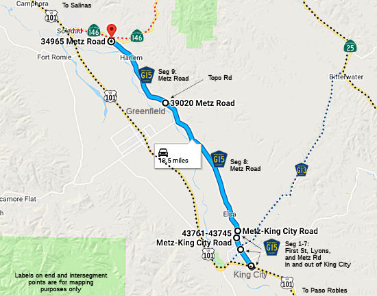 First Street in King City from US 101 to the King City city limits (FAS, 0.20 mi)
First Street from the King City city limits to the King City city limits (FAS, 0.37 mi)
First Street in King City from the King City city limits to Lyons Street (FAS, 0.68 mi)
Lyons Street in King City from First Street to Metz Road (FAS, 0.05 mi)
Metz Road in King City from Lyons Street to the King City city limits (FAS, 0.22)
Metz Road outside King City from the King City city limits to the King City city limits (FAS, 0.40 mi)
Metz Road inside King City (FAS, 0.12 mi)
Metz Road from the King City city limits to Topo Road near Greenfield (FAS, 10.36 mi)
Metz Road from Topo Road near Greenfield to Route 146 near Soledad (FAS, 6.28 mi)
 History and Signage Information
This route was defined in 1965.
 Status
Total mileage: 18.68 mi.
Status© 1996-2024 Daniel P. Faigin.
Maintained by: Daniel P. Faigin
<webmaster@cahighways.org>.
 CR G14
 CR G16