
 California Highways:
[Click here for a key to the symbols used. Some county routes were constructed with federal funds. These routes are indicated as FAP (Federal Aid Primary), FAU (Federal Aid Urban), or FAS (Federal Aid Secondary). If no funding source is shown, no federal funds were used. Note that while some segments seem to have the same attributes, they may differ in the county-local road number assigned to the segment, or in the Caltrans Map Sheet number.]
 Routing
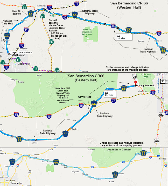 National Trails Highway, beginning in the community of Oro Grande to Goffs Road,
and then continuing northerly on Goffs Road to its junction with US 95.
National Trails Highway, beginning in the community of Oro Grande to Goffs Road,
and then continuing northerly on Goffs Road to its junction with US 95.
 Status
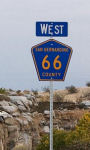 This route was created on September 27, 2011 (Resolution 63) by the San
Bernardino County Board of Supervisors. Per the resolution, Caltrans was
requested to install marker signs on I-40, Route 58, Route 247, and I-15
in the Barstow Area, and US 95 in the Goffs Area. The resolution also
recommended that the County provide San Bernardino County Sign Route 66 signs and
materials to the City of Barstow for marking the route within the City, as
this program supports the County’s goals, and objectives and
supports the social needs of the population of the County. It was noted
that this alignment can be expanded to include additional portions of or
the entire Route 66 at a later date. It was also noted that at their
September 19, 2011, meeting, the Barstow City Council agreed to
participate with the County in establishing this program and adopted a
resolution that established County Route 66 within its municipal limits.
In Barstow, the route is along Main Street.
This route was created on September 27, 2011 (Resolution 63) by the San
Bernardino County Board of Supervisors. Per the resolution, Caltrans was
requested to install marker signs on I-40, Route 58, Route 247, and I-15
in the Barstow Area, and US 95 in the Goffs Area. The resolution also
recommended that the County provide San Bernardino County Sign Route 66 signs and
materials to the City of Barstow for marking the route within the City, as
this program supports the County’s goals, and objectives and
supports the social needs of the population of the County. It was noted
that this alignment can be expanded to include additional portions of or
the entire Route 66 at a later date. It was also noted that at their
September 19, 2011, meeting, the Barstow City Council agreed to
participate with the County in establishing this program and adopted a
resolution that established County Route 66 within its municipal limits.
In Barstow, the route is along Main Street.
As of 2019, it was reported that the route was signed to the terminus in Needles.
Bridge Replacement
In 2021, a Draft EIR was published regarding
replacement of a number of historic bridges.
(Source: SBD County "Notice of Preparation of a Draft Environmental Impact Report for the National Trails Highway at 10 Bridges Project", April 2021)
| Bridge Name |
Bridge Number |
Existing Bridge Length |
Existing Bridge Width |
Location |
| Bristol Ditch | 54C0272 | 40 feet | 28 feet | 26.7 miles east of Crucero Rd |
| Cerro Ditch | 54C0275 | 40 feet | 28 feet | 1.3 miles east of Amboy Rd |
| Gordo Ditch | 54C0276 | 40 feet | 28 feet | 1.8 miles east of Amboy Rd |
| Cerulia Ditch | 54C0277 | 40 feet | 28 feet | 2.2 miles east of Amboy Rd |
| Leith Ditch | 54C0279 | 40 feet | 28 feet | 3.1 miles east of Amboy Rd |
| Terra Ditch | 54C0280 | 40 feet | 28 feet | 3.6 miles east of Amboy Rd |
| Sombra Ditch | 54C0281 | 78 feet | 28 feet | 4.1 miles east of Amboy Rd |
| Beacon Ditch | 54C0282 | 40 feet | 28 feet | 6.2 miles east of Amboy Rd |
| Larissa Ditch | 54C0284 | 40 feet | 27 feet | 1.1 miles east of Kelbaker Rd |
| Adena Ditch | 54C0315 | 59 feet | 28 feet | 21.9 miles east of Kelbaker Rd |
 The County of San Bernardino, in coordination with
Caltrans, is proposing to replace 10 bridges on the National Trails
Highway (NTH), also known as former US 66. The existing bridges were
constructed in 1930 with simple timber girders and a continuous
castin-place/reinforced concrete deck. The bridges span over various
manmade ditches that were created to channel surface drainage flows. The
bridges are supported on closed-end backfilled timber pile extension
strutted abutments and timber pile extension bents. They now have asphalt
overlays. At Cerro, Gordo, Cerulia, Leith, Terra, Sombra, Beacon and
Larissa supplemental timber bents and columns were installed at the
midspan doubling the number of supports and spans at these bridges. All
ten existing bridges are classified Structurally Deficient and have
sufficiency ratings from 22.2 to 61.2. All but Bristol Ditch has a
sufficiency rating below 50. The existing bridges are proposed to be
replaced with reinforced concrete bridges. The existing soil is sandy and
susceptible to scour, so pile extensions would be utilized at the piers
and the abutment foundation would be supported on piles. The bridge
barrier would be steel California ST-75 Bridge Rail painted white which is
Manual for Assessing Safety Hardware (MASH) approved and best matches the
existing railing. The bridge lengths would match the existing lengths if
possible, but would be lengthened as needed to convey the storm flows. The
width of each replacement bridge would be 40 feet to accommodate two
12-foot lanes, two 6-foot shoulders and the 2-foot railing. The vertical
profile of the bridges will remain close to the existing profile except
for those bridges locations in which it is determined that additional
vertical clearance is required to provide sufficient water conveyance
beneath the bridge. It is anticipated that any such necessary changes in
vertical profiles would be 2 feet or less, with the elevation gradually
conforming to the existing roadway elevations.
The County of San Bernardino, in coordination with
Caltrans, is proposing to replace 10 bridges on the National Trails
Highway (NTH), also known as former US 66. The existing bridges were
constructed in 1930 with simple timber girders and a continuous
castin-place/reinforced concrete deck. The bridges span over various
manmade ditches that were created to channel surface drainage flows. The
bridges are supported on closed-end backfilled timber pile extension
strutted abutments and timber pile extension bents. They now have asphalt
overlays. At Cerro, Gordo, Cerulia, Leith, Terra, Sombra, Beacon and
Larissa supplemental timber bents and columns were installed at the
midspan doubling the number of supports and spans at these bridges. All
ten existing bridges are classified Structurally Deficient and have
sufficiency ratings from 22.2 to 61.2. All but Bristol Ditch has a
sufficiency rating below 50. The existing bridges are proposed to be
replaced with reinforced concrete bridges. The existing soil is sandy and
susceptible to scour, so pile extensions would be utilized at the piers
and the abutment foundation would be supported on piles. The bridge
barrier would be steel California ST-75 Bridge Rail painted white which is
Manual for Assessing Safety Hardware (MASH) approved and best matches the
existing railing. The bridge lengths would match the existing lengths if
possible, but would be lengthened as needed to convey the storm flows. The
width of each replacement bridge would be 40 feet to accommodate two
12-foot lanes, two 6-foot shoulders and the 2-foot railing. The vertical
profile of the bridges will remain close to the existing profile except
for those bridges locations in which it is determined that additional
vertical clearance is required to provide sufficient water conveyance
beneath the bridge. It is anticipated that any such necessary changes in
vertical profiles would be 2 feet or less, with the elevation gradually
conforming to the existing roadway elevations.
(Source: SBD County "Notice of Preparation of a Draft Environmental Impact Report for the National Trails Highway at 10 Bridges Project", April 2021)
The National Trails Highway is posted at a speed limit
of 55 miles per hour, with all the bridges located on straight segments of
the road. The alignment would remain unchanged; however, approach road
work, up to 800 feet, on either side of each bridge may be needed to
conform to the existing roadway vertical profile. Grading along the
approaches and around the bridges may be needed to ensure storm conveyance
and drainage of the area. Temporary low-water crossing detours would be
constructed to accommodate through-traffic during construction.
Construction of each bridge replacement is expected to be completed in one
season, limiting the time the detour would be in place to one season as
well. Permanent acquisition of right-of-way is not anticipated to be
needed; however, temporary construction easements may be needed to
accommodate construction of the temporary detour routes. The existing
utilities include a fiber optic telecommunication line and a solar powered
local utility line. Both of these utilities may require relocation as part
of this project. All utility relocations would be included within the
defined limits of the 10 Bridges project area.
(Source: SBD County "Notice of Preparation of a Draft Environmental Impact Report for the National Trails Highway at 10 Bridges Project", April 2021)
 Historical Route
This route is part of "Historic Highway Route 66", designated by Assembly Concurrent Resolution 6, Chapter 52, in 1991.
 Return to County Routes
 CR 680
© 1996-2020 Daniel P. Faigin.
Maintained by: Daniel P. Faigin
<webmaster@cahighways.org>.