
 California Highways:
[Click here for a key to the symbols used. Some county routes were constructed with federal funds. These routes are indicated as FAP (Federal Aid Primary), FAU (Federal Aid Urban), or FAS (Federal Aid Secondary). If no funding source is shown, no federal funds were used. Note that while some segments seem to have the same attributes, they may differ in the county-local road number assigned to the segment, or in the Caltrans Map Sheet number.]
 Routing
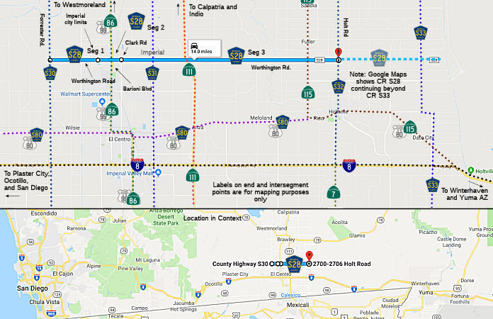 Worthington Road from Forrester Road (County Sign Route S30) to the Imperial city limits (FAS, 2.30
mi)
Worthington Road from Forrester Road (County Sign Route S30) to the Imperial city limits (FAS, 2.30
mi)
Barioni Blvd Main Street in Imperial from Imperial
city limits to Clark Road (North P Street) (FAS, 1.00 mi)
Worthington Road from Clark Road (North P Street) to Holt Road (County Sign Route S32) (FAS, 10.70 mi)
Note: Google Maps shows County Sign Route S8 continuing E to County Sign Route S33 (if not a bit beyond).
 History and Signage Information
This route was defined in 1970.
 Status
The section of Worthington Road east of County Sign Route S32 (i.e., the erroneous
Google Maps eastern extension) is unpaved. Looking closer at Google Maps,
it appears Graeser Road / the East Highline Canal are considered the
eastern terminus of this “paper” extension of County Sign Route S28 past both
County Sign Route S32 (Holt Road) and County Sign Route S33 (Highline Road). While there is no
“END” or “BEGIN” shields for County Sign Route S28 at its eastern
terminus with County Sign Route S32, the signage indicating the intersection with County Sign Route S28
along NB County Sign Route S32 makes it clear that County Sign Route S28 only continues west from the
intersection (i.e., a left turn arrow is shown).
(Source: Adrian Ople in private email, 8/21/2026)
The intersection of County Sign Route S33 and Worthington Road is a very minor one.
There are yellow intersection signs or green roadside signs indicating the
intersection. The only signage for this intersection is a standard street
name pole for intersections located about 40 feet off County Sign Route S33, which is a
bit far.
(Source: Adrian Ople in private email, 8/21/2026)
Similar to how Google Maps extends its signage of County Sign Route S28 east of its
legal terminus, Google Maps extends signage of County Sign Route S28 west of its legal
terminus at County Sign Route S30 up to Huff Road (about 5.8 miles). No part of this
section of Worthington Road is actually signed, but, unlike the erroneous
western extension of County Sign Route S27 and eastern extension of County Sign Route S28, this section
is actually paved, and combined with Huff Road could be considered a route
between Imperial and Dixieland. The intersection of Huff and Worthington
includes a wye-style curve for traffic going from NB Huff to EB
Worthington, lending more credibility to the Dixieland-Imperial route
consideration. The road is well-maintained (even being in a much better
conditions than the portion of County Sign Route S26 west of Brandt Road) and includes
signage indicating distance from the City of Imperial. Therefore, even if
it’s not legally considered part of County Sign Route S28, Worthington Road between
Huff and Forrester could be considered a de facto portion of the route.
This de facto route consideration could also be extended to Huff Road from
Old US 80 to Worthington.
(Source: Adrian Ople in private email, 8/21/2026)
Signage at the western terminus of County Sign Route S28 implies that the route does
continue west on Worthington past County Sign Route S30 (Forrester Road). NB County Sign Route S30
includes a County Sign Route S28 shield with bidirectional arrows, indicating that the
road continues both west and east from the intersection. SB County Sign Route S30 does
not have this issue, instead showing a left arrow. WB County Sign Route S28 does not show
an “END” shield, but instead a shield with a
“forward” arrow sign. Obviously, this implies that WB County Sign Route S28
continues onward past Forrester Road, even though this isn’t legally
true. The first EB shield for County Sign Route S28 also shows a forward arrow, rather
than a “BEGIN” sign.
(Source: Adrian Ople in private email, 8/21/2026)
Total mileage: 14.00 mi.
© 1996-2024 Daniel P. Faigin.
Maintained by: Daniel P. Faigin
<webmaster@cahighways.org>.
 CR S27
 CR S29