
 California Highways:
[Click here for a key to the symbols used. Some county routes were constructed with federal funds. These routes are indicated as FAP (Federal Aid Primary), FAU (Federal Aid Urban), or FAS (Federal Aid Secondary). If no funding source is shown, no federal funds were used. Note that while some segments seem to have the same attributes, they may differ in the county-local road number assigned to the segment, or in the Caltrans Map Sheet number.]
 Routing
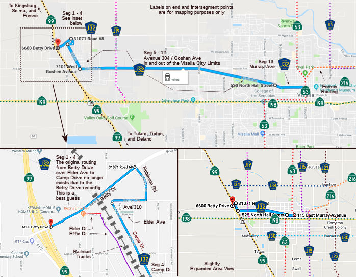 Betty Drive (Diagonal 66) from Route 99 to Elder Avenue (0.14 mi)
Note: The specific routing from Betty Drive to Camp Drive appears to have been superseded by the 2018 Betty Drive interchange project on Route 99. This impacts Segments 1 thorugh 4. A best guess routing is shown based on the new alignments.
Elder Avenue (Avenue 309) from Betty Drive to Effie Drive (0.08 mi)
Note: The specific routing from Betty Drive to Camp Drive appears to have been superseded by the 2018 Betty Drive interchange project on Route 99. This impacts Segments 1 thorugh 4. A best guess routing is shown based on the new alignments.
Elder Avenue (Avenue 309A) from Effie Drive to Camp Drive (0.09 mi)
Note: The specific routing from Betty Drive to Camp Drive appears to have been superseded by the 2018 Betty Drive interchange project on Route 99. This impacts Segments 1 thorugh 4. A best guess routing is shown based on the new alignments.
Camp Drive (Diagonal 76) from Elder Avenue to Avenue 304 (0.80 mi)
Avenue 304 from Camp Drive to the Visalia city limits (FAS, 0.18 mi)
Note: The Visalia city limits appear to have been expanded since the definition to extend to Camp Drive.
Goshen Avenue in Visalia from the Visalia city limits to the Visalia urban limits (FAU, 0.40 mi)
Goshen Avenue in Visalia from the Visalia urban limits to Road 84 (FAU, 1.00 mi)
Goshen Avenue (Avenue 304) from Road 84 to Shirk Road (FAU, 1.00 mi)
Goshen Avenue in Visalia from Shirk Road to the Visalia city limits (FAU, 0.25 mi)
Goshen Avenue (Avenue 304) from the Visalia city limits to Akers Road (FAU, 0.75 mi)
Goshen Ave (Diagonal 117B) from Akers Road to the Visalia city limits (FAU, 1.89 mi)
Goshen Avenue in Visalia from the Visalia city limits to Gidding Avenue (FAU, 0.68 mi)
Murry Avenue in Visalia from Gidding Avenue to Court Street (Route 63) (FAU, 0.72 mi)
 History and Signage Information
This route was defined in 1972.
 Status
Total mileage: 7.98 mi.
© 1996-2020 Daniel P. Faigin.
Maintained by: Daniel P. Faigin
<webmaster@cahighways.org>.
 CR J31
 CR J33