
 California Highways:
[Click here for a key to the symbols used. Some county routes were constructed with federal funds. These routes are indicated as FAP (Federal Aid Primary), FAU (Federal Aid Urban), or FAS (Federal Aid Secondary). If no funding source is shown, no federal funds were used. Note that while some segments seem to have the same attributes, they may differ in the county-local road number assigned to the segment, or in the Caltrans Map Sheet number.]
 Routing
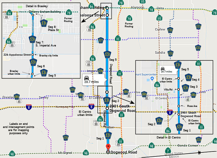 Dogwood Road from Route 98 to the El Centro urban limits (FAS, 6.44 mi)
Dogwood Road from the El Centro urban limits to Ross Ave (FAU, 0.60 mi)
Dogwood Road in El Centro from Ross Ave to Villa Road (FAU, 1.56 mi)
Dogwood Road from Villa Road to the El Centro urban limits (FAU, 0.10 mi)
Dogwood Road from the El Centro urban limits to the Brawley urban limits (FAS, 10.91 mi)
Dogwood Road from the Brawley urban limits to the Brawley city limits (FAU, 0.39 mi)
Imperial Avenue in Brawley from the Brawley city limits to Plaza Street (FAU, 0.58 mi)
Plaza Street in Brawley from Imperial Avenue to Main Street (Former Route 78) (FAU, 0.10 mi)
In 2022, Google Maps was also showing County Sign Route S31 routed along K Street and S 8th Street from Imperial Avenue to Main Street. According to the City of Brawley, there is a northbound reassurance shield along S. 8th Street, northbound, immediately south of Main Street / Old Hwy 78.
In 2022, Google Maps was also showing County Sign Route S31 routed N from Main Street along N 8th Street/Former Highway 111 to the Route 78 Brawley Bypass. According to the City of Brawley, there is a reassurance sign on WB Main Street between the Southern Pacific Railroad tracks and the intersection of Main/Old Hwy 78; additionally, 8th/Old Hwy 111 shows a shield for County Sign Route S31 with arrows pointing both north and south as well. However, the signage for County Sign Route S31 on Old Hwy 78 WB actually contradicts the signage on NB 8th Street approaching Old Hwy 78. On Old Hwy 78 / Main Street there is a bidirectional arrow underneath the shield. However, there is an extremely faded “END” sign underneath the shield on 8th Street.
 History and Signage Information
This route was defined in 1970.
 Status
Total mileage: 20.68 mi.
© 1996-2024 Daniel P. Faigin.
Maintained by: Daniel P. Faigin
<webmaster@cahighways.org>.
 CR S30
 CR S32