
 California Highways:
Click here for a key to the symbols used. An explanation of acronyms may be found at the bottom of the page.
 Routing
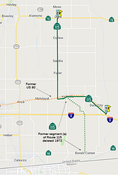 From Route 8 southeasterly of Holtville to Route 78.
 Post 1964 Signage History
In 1963, this segment was the original segment (b) of Route 115, and (a) and (b) were defined as "(a) Route 98 near Bonds Corners to Route 8 near Holtville. (b) Route 8 near Holtville to Route 78."
In 1972, Chapter 742 deleted (a) and changed the origin of (b): (a) Route 8 southeasterly of Holtville to Route 78. This reflected relocation of a portion of this route to a former alignment of Route 8. This former part (a) was once US 80.
 Pre 1964 Signage History
This segment was part of LRN 187, defined in 1933—in particular, the first segment was defined as "[LRN 27] near Holtville to Calexico-Midway Wells Road near Bonds Corner". This was added to the state highway code in 1935 as "[LRN 27] near Holtville to [LRN 202] near Bonds Corner". The segment also included a portion of LRN 27, defined as the route from El Centro to Yuma. This segment first appears on state highway maps as Sign Route 115 in 1956. Sign Route 115 was not defined in the initial set of signed routes in 1934.
As of 1934, the original segment (a) between Bonds Corner and Holtville
ran along Bonds Corner Road and Walnut Avenue. The revised definition runs
along Evan Hewes Avenue (US Highway 80) from I-8 to Holtville. LRN 187
then followed Holt Road and Hartshorn Road to modern Ben Hulse Highway
near Alamoria. In 1959, Sign Route 115 was realinged to bypass Holt
Road and Hartshorn Road in favor of a direct routing to Sandia Corner via
a new bridge over the Alamo River. The realignment left the route as
running along US 80 via Evan Hewes Highway, Palm Avenue and 5th Street to
Walnut Aveune in Holtville.
(Source: Gribblenation Blog (Tom Fearer), "California State Route 115", 7/9/2023)
The second segment was part of LRN 201.
 Status
The SAFETEA-LU act, enacted in August 2005 as the reauthorization of TEA-21, provided the following expenditures on or near this route:
 Named Structures
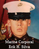 The Alamo River Bridge (IMP 10.09, Bridge 58 0292, Built 1959) on the Evan Hewes Highway (Route 115) at the entry to the City of
Holtville, California, is named the Marine Corporal Erik H. Silva
Memorial Bridge. It was named after Marine Corporal Erik H. Silva,
who was only 22 years of age when he died as his platoon was ambushed on
April 3, 2003. Cpl. Silva was born in September 1980, in Brawley,
California, and grew up in the City of Holtville, California. He graduated
from Holtville High School in 1998. Erik was known as a quiet, friendly,
well-liked kid who played the trumpet in the band, and was a member of the
varsity golf team, a soccer player, and a drum major his last two years of
high school. Marine Corporal Silva, an infantry rifleman, died in combat
when his platoon was ambushed in Iraq during Operation Iraqi Freedom;
Marine Corporal Silva was assigned to the 3rd Battalion, 5th Marines, 1st
Marine Division, Camp Pendleton, California. Erik was the third sibling to
serve in the United States Armed Forces with his older brother Isaac Silva
serving a total of 12 years in the United States Air Force and the
California Army National Guard while his older sister Gloria Silva served
10 years in the United States Navy. He also had numerous uncles and aunts
who have served honorably in the United States Armed Forces. At the time
of his death, Silva was nearly six months short of completing his first
enlistment before being honorably discharged to then seek a career with
the Department of the California Highway Patrol. Named by Assembly
Concurrent Resolution 37, Resolution Chapter 121, 7/23/2019.
The Alamo River Bridge (IMP 10.09, Bridge 58 0292, Built 1959) on the Evan Hewes Highway (Route 115) at the entry to the City of
Holtville, California, is named the Marine Corporal Erik H. Silva
Memorial Bridge. It was named after Marine Corporal Erik H. Silva,
who was only 22 years of age when he died as his platoon was ambushed on
April 3, 2003. Cpl. Silva was born in September 1980, in Brawley,
California, and grew up in the City of Holtville, California. He graduated
from Holtville High School in 1998. Erik was known as a quiet, friendly,
well-liked kid who played the trumpet in the band, and was a member of the
varsity golf team, a soccer player, and a drum major his last two years of
high school. Marine Corporal Silva, an infantry rifleman, died in combat
when his platoon was ambushed in Iraq during Operation Iraqi Freedom;
Marine Corporal Silva was assigned to the 3rd Battalion, 5th Marines, 1st
Marine Division, Camp Pendleton, California. Erik was the third sibling to
serve in the United States Armed Forces with his older brother Isaac Silva
serving a total of 12 years in the United States Air Force and the
California Army National Guard while his older sister Gloria Silva served
10 years in the United States Navy. He also had numerous uncles and aunts
who have served honorably in the United States Armed Forces. At the time
of his death, Silva was nearly six months short of completing his first
enlistment before being honorably discharged to then seek a career with
the Department of the California Highway Patrol. Named by Assembly
Concurrent Resolution 37, Resolution Chapter 121, 7/23/2019.
(Image source: Facebook)
 Historical Route
 ACR 123 (Resolution Chapter 104, 8/16/2006) designated segments of former U.S. Highway Route 80 in San Diego and Imperial Counties as Historic
U.S. Highway Route 80, and requested the Department of
Transportation to design and facilitate the posting of appropriate signs
and take related actions in that regard. The resolution noted that US 80,
largely parallel to current I-8, was a 180-mile highway spanning San Diego
and Imperial Counties from San Diego Bay to the Colorado River, and played
a major role in the development of this state during much of the 20th
century. In 1909, California voters approved a statewide bond measure for
road improvement purposes in the amount of $18 million, providing, among
other things, funds to construct a road between San Diego and Imperial
Counties, and their county seats of San Diego and El Centro. In 1915, a
unique wood plank road was built over the Imperial Valley sand hills,
resulting in a shorter route. In 1925, the federal government became
involved in standardized highway route designations across the nation and
even numbers were assigned to major highways running east and west, and
odd numbers for highway running north and south. The numbering of highways
proceeded in numerical order beginning in the north and east and
continuing south and west, respectively, and, as a result, the routing
along California's southern border was formally designated as US 80. This
road, from San Diego to Tybee Island, Georgia, was adopted as US 80 on
November 11, 1926. US 80 was the first ocean-to-ocean transcontinental
highway to be completed, and portions of the route were known as the
Bankhead, Broadway of America, Dixie, Lee, Old Spanish Trail, and Southern
Transcontinental Highway.
ACR 123 (Resolution Chapter 104, 8/16/2006) designated segments of former U.S. Highway Route 80 in San Diego and Imperial Counties as Historic
U.S. Highway Route 80, and requested the Department of
Transportation to design and facilitate the posting of appropriate signs
and take related actions in that regard. The resolution noted that US 80,
largely parallel to current I-8, was a 180-mile highway spanning San Diego
and Imperial Counties from San Diego Bay to the Colorado River, and played
a major role in the development of this state during much of the 20th
century. In 1909, California voters approved a statewide bond measure for
road improvement purposes in the amount of $18 million, providing, among
other things, funds to construct a road between San Diego and Imperial
Counties, and their county seats of San Diego and El Centro. In 1915, a
unique wood plank road was built over the Imperial Valley sand hills,
resulting in a shorter route. In 1925, the federal government became
involved in standardized highway route designations across the nation and
even numbers were assigned to major highways running east and west, and
odd numbers for highway running north and south. The numbering of highways
proceeded in numerical order beginning in the north and east and
continuing south and west, respectively, and, as a result, the routing
along California's southern border was formally designated as US 80. This
road, from San Diego to Tybee Island, Georgia, was adopted as US 80 on
November 11, 1926. US 80 was the first ocean-to-ocean transcontinental
highway to be completed, and portions of the route were known as the
Bankhead, Broadway of America, Dixie, Lee, Old Spanish Trail, and Southern
Transcontinental Highway.
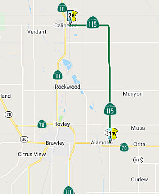 From Route 78 east of Brawley to Route 111 at Calipatria.
Post 1964 Signage HistoryThis segment remains as defined in 1963.
Pre 1964 Signage HistoryThis was LRN 201, defined in 1933 as "From a point on [LRN 26] approximately 2 mi W of Brawley to a point on said [LRN 26] approximately 2½ mi SW of Brawley" and "Calipatria to Brawley-Holtville Road". This was added to the state highway code in 1935 as (1) Calipatria to LRN 187 between Brawley and Holtville; (2) LRN 26 east of Heber to LRN 187 near Brawley." Sign Route 115 was not defined in the initial set of signed routes in 1934; by the 1956 state highway map, this segment was shown as Sign Route 115.
The LRN 201 routing at this time ran from Alamoria following West Road,
Wirt Street to Main Street in Calipatria.
(Source: Gribblenation Blog (Tom Fearer), "California State Route 115", 7/9/2023)
 Other WWW Links
 Interstate Submissions
In April 1958, it appears that the designation I-115 was proposed for the route that is now I-505. This was part of the first attempt to assign 3-digit interstates n California. The number was rejected by AASHTO.
 Statistics
Overall statistics for Route 115:
 Pre-1964 Legislative Route
In 1933, Chapter 767 added the route from "[LRN 5] near San Jose to Mount Hamilton" to the highway system. In 1935, this was defined in the highway code as LRN 115 with that definition.
In 1959, Chapter 1062 changed the definition to:
Later in 1959, Chapter 2065 and 2144 extended the second segment to "Patterson via the vicinity of Mount Hamilton."
In 1961, Chapter 1146 deleted segment (a)
This route ran from Bypass US 101 near San Jose to Patterson via the vicinity of Mount Hamilton, and is present-day Route 130.
© 1996-2020 Daniel P. Faigin.
Maintained by: Daniel P. Faigin
<webmaster@cahighways.org>.
 Route 114
 Route 116