
 California Highways:
Click here for a key to the symbols used. An explanation of acronyms may be found at the bottom of the page.
 Routing
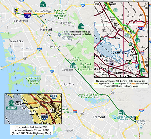 (a) From Route 680 in Fremont to Route 61 near San Lorenzo via Hayward.
(b) The relinquished former portion of Route 238 within the City of Hayward is not a state highway and is not eligible for adoption under Section 81. For the relinquished former portion of Route 238, the City of Hayward shall maintain within its jurisdiction signs directing motorists to the continuation of Route 238 or to the state highway system, as applicable.
(c) (1) The commission may relinquish to the City of Hayward all or any portion of Route 238 located within the city limits of that city, upon terms and conditions the commission finds to be in the best interests of the state, if the department and the city enter into an agreement providing for that relinquishment.
(2) A relinquishment under this subdivision shall become effective immediately after the county recorder’s recordation of the relinquishment resolution containing the commission’s approval of the terms and conditions of the relinquishment.
(3) On and after the effective date of the relinquishment, both of the following shall occur:
(A) The portion of Route 238 relinquished shall cease to be a state highway.
(B) The portion of Route 238 relinquished shall be ineligible for future adoption under Section 81.
(4) For relinquished portions of Route 238, the City of Hayward shall maintain signs within its jurisdiction directing motorists to the continuation of Route 238 or to the state highway system, as applicable.
 Post 1964 Signage History
In 1963, Route 238 was defined as “Route 680 near Warm Springs to Route 61 near San Lorenzo via Hayward.”
In 1965, Chapter 1371 changed the origin to “Route 680 near
Warm
Springs in Fremont to …”
Prior to the completion of the freeway routing of I-680 S from Mission San Jose to San Jose, the surface street legislative routing of Route 680 was signed as Route 238 (i.e., along Mission Blvd and Oakland Road) to US 101. This corresponds to old LRN 5, which was signed as Route 9/Route 21 prior to 1964.
In 2009, AB 1386 (Chapter 291, 10/11/2009) authorized relinquishment of the portion of the route in the City of Hayward by adding:
(b) (1) The commission may relinquish to the City of Hayward the portion of Route 238 located within the city limits of that city, upon terms and conditions the commission finds to be in the best interests of the state, if the department and the city enter into an agreement providing for that relinquishment.
(2) A relinquishment under this subdivision shall become effective immediately after the county recorder's recordation of the relinquishment resolution containing the commission's approval of the terms and conditions of the relinquishment.
(3) On and after the effective date of the relinquishment, both of the following shall occur: (A) The portion of Route 238 relinquished shall cease to be a state highway. (B) The portion of Route 238 relinquished shall be ineligible for future adoption under Section 81.
(4) For relinquished portions of Route 238, the City of Hayward shall maintain signs within its jurisdiction directing motorists to the continuation of Route 238 or to the state highway system, as applicable.
In July 2010, the CTC approved relinquishing right of way in the city of Hayward on Route 238 (Mission Boulevard/Foothill Boulevard) from Industrial Parkway to Apple Avenue, under terms and conditions stated in the letter dated June 1, 2010, determined to be in the best interests of the State. Authorized by Chapter 291, Statutes of 2009, which amended Section 538 of the Streets and Highways Code.
In 2012, AB 2679 (Chapter 769, 9/29/2012) updated the language to reflect the relinquishment in Hayward:
(b) (1) The commission may relinquish to the City of Hayward the portion of Route 238 located within the city limits of that city, upon terms and conditions the commission finds to be in the best interests of the state, if the department and the city enter into an agreement providing for that relinquishment.
(2) A relinquishment under this subdivision shall become effective immediately after the county recorder’s recordation of the relinquishment resolution containing the commission’s approval of the terms and conditions of the relinquishment.
(3) On and after the effective date of the relinquishment, both of the following shall occur:
(A) The portion of Route 238 relinquished shall cease to be a state highway.
(B) The portion of Route 238 relinquished shall be ineligible for future adoption under Section 81.
(4)(b)For relinquished portionsThe relinquished former portion of Route 238 within the City of Hayward is not a state highway and is not eligible for adoption under Section 81. For the relinquished former portion of Route 238, the City of Hayward shall maintainsignswithin its jurisdiction signs directing motorists to the continuation of Route 238 or to the state highway system, asapplicable.applicable, and shall ensure the continuity of traffic flow on the relinquished portion of Route 238, including any traffic signal progression.
In 2015, SB 491, Chapter 451, 10/2/15, removed the language about ensuring the continuity of traffic flow, and added item (c):
(c) (1) The commission may relinquish to the City of Hayward all or any portion of Route 238 located within the city limits of that city, upon terms and conditions the commission finds to be in the best interests of the state, if the department and the city enter into an agreement providing for that relinquishment.
(2) A relinquishment under this subdivision shall become effective immediately after the county recorder’s recordation of the relinquishment resolution containing the commission’s approval of the terms and conditions of the relinquishment.
(3) On and after the effective date of the relinquishment, both of the following shall occur:
(A) The portion of Route 238 relinquished shall cease to be a state highway.
(B) The portion of Route 238 relinquished shall be ineligible for future adoption under Section 81.
(4) For relinquished portions of Route 238, the City of Hayward shall maintain signs within its jurisdiction directing motorists to the continuation of Route 238, or to the state highway system, as applicable.
Note that for a long time, the routings of present-day Route 238 and Route 9 were duplicated. After Route 680 was built between the two Mission Blvds, Mission lost the designation as Route 238, until reaching the northernmost interchange. Also, at one time there was talk of having Route 238 use the routing of Warm Springs Blvd and Old Oakland Hwy. A couple of maps showed the signage as such, and this is confirmed in a 1966 CHPW.
In October 2017, the CTC authorized relinquishment of right of way in the city of Hayward on Route 238 (Mission Boulevard) from the Hayward city limits to Industrial Parkway (04-Ala-238-PM 7.8/9.3), under terms and conditions as stated in the relinquishment agreement dated August 29, 2017, determined to be in the best interest of the State. Authorized by Chapter 451, Statutes of 2015, which amended Section 538 of the Streets and Highways Code.
 The portion between Route 880 and unconstructed Route 61is
unconstructed. The traversable local routing is along Lewelling Boulevard.
A freeway route has not been adopted.
The portion between Route 880 and unconstructed Route 61is
unconstructed. The traversable local routing is along Lewelling Boulevard.
A freeway route has not been adopted.
Mission Freeway / Hayward Bypass / Route 238 Corridor in Hayward
Where Route 238 veers off of I-680, between the Durham and Washington exits, where I-680 makes a turn, there is an overpass over the southbound lanes and some pavement suggesting that there might have been an exit from the leftmost northbound lane and an "entrance" to the leftmost southbound lane. This is the beginning of a proposed "Mission" Freeway (upgrade of Route 238) that was never built.
 The proposed Foothill Freeway, also known as the Hayward
Bypass, was born on June 21, 1961, when the California Highway Commission
(CHC) adopted a location for Route 238 as a Freeway in Alameda County
between I-680 and I-580 through the cities of Fremont and Hayward. The CHC
also adopted as a freeway other segments of Route 238 through Alameda
County on June 21, 1961, December 15, 1965, and July 20, 1967. Following
those actions by the CHC, the Department executed freeway agreements with
the City of Fremont on December 21, 1966 and April 24, 1967; the City of
Hayward on October 5, 1965 and March 13, 1984; and the County of Alameda
on October 9, 1964, January 14, 1967, and March 13, 1984. The Department
acquired much of the right of way for construction of the adopted Route 238 in the late 1960’s and early 1970’s. Caltrans agents,
using the threat of eminent domain, bought up 620 parcels -- some with
homes or business -- in and around Hayward. This freeway would have
traversed the Hayward foothills from Route 580 in Castro Valley to Route 680 in Mission San Jose, while providing regional congestion relief with
Central Alameda County.
The proposed Foothill Freeway, also known as the Hayward
Bypass, was born on June 21, 1961, when the California Highway Commission
(CHC) adopted a location for Route 238 as a Freeway in Alameda County
between I-680 and I-580 through the cities of Fremont and Hayward. The CHC
also adopted as a freeway other segments of Route 238 through Alameda
County on June 21, 1961, December 15, 1965, and July 20, 1967. Following
those actions by the CHC, the Department executed freeway agreements with
the City of Fremont on December 21, 1966 and April 24, 1967; the City of
Hayward on October 5, 1965 and March 13, 1984; and the County of Alameda
on October 9, 1964, January 14, 1967, and March 13, 1984. The Department
acquired much of the right of way for construction of the adopted Route 238 in the late 1960’s and early 1970’s. Caltrans agents,
using the threat of eminent domain, bought up 620 parcels -- some with
homes or business -- in and around Hayward. This freeway would have
traversed the Hayward foothills from Route 580 in Castro Valley to Route 680 in Mission San Jose, while providing regional congestion relief with
Central Alameda County.
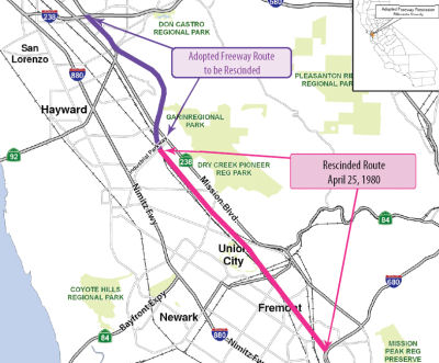
Opposition to the Route 238 Hayward Bypass happened almost from the date of adoption. A class action lawsuit was filed in June 1971 seeking to halt land acquisition, relocation activities and other preparations for the project. In November of 1971, a preliminary court injunction to halt the project was issued by the United States District Court for Northern California and reaffirmed on appeal in November 1973. On April 25, 1980, the CHC rescinded that portion of the adopted Route 238 freeway location from I-680 to Industrial Parkway in the city of Hayward. In addition, the Commission’s rescission resolution obligated the portion of Route 238 from Industrial Parkway to I-580 to have a funding plan in place within two years (e.g., by 1982). If a financial plan was not forthcoming by 1982, the remainder of Route 238 would be rescinded. Subsequently, in 1982, legislation (AB 3179, Holmdahl) created a process to allow local public agencies to develop an alternative transportation project or projects (LATIP) to address congestion on existing Route 238 and to provide flexibility to local decision makers by ensuring that the investment of funds on the adopted freeway alignment would not preclude consideration of other options. Subsequent to this resolution, legislation was passed to allow additional time to develop a funding plan for the remaining Route 238 location. Current Government Code Section 14528.5 requires that a funding plan be approved before July 1, 2010.
Scott Parker (SParker) on AAroads had the following relevant observations
on the proposed Route 238 freeway:
(Source: Scott Parker (SParker) on AAroads, 7/24/2018)
The originally adopted Route 238 freeway alignment (adopted back when it was still Pre-1964 Route 9) was about two blocks east of Foothill, essentially behind the rear-parking area for the downtown businesses along Foothill and would have isolated the residential area to the east from the business district. Heading south, it sat at the bottom of the hill below (then) CSU Hayward before cutting across Mission Blvd and angling SSE through the eastern portion of Union City before assuming a pathway directly alongside BART, eventually ending at I-680 at the bottom of the Sunol Grade hill. The downtown Hayward and Union City sections were the most controversial circa 1971-72; both residents of the east side of Hayward and Latino activists in Union City sued the then-Division of Highways; initially to force a relocation of the freeway but, when the Division demurred, claiming the adopted route was the only reasonable alternative, to permanently enjoin the freeway's construction and rescind the adopted route. The Hayward suit was dropped in favor of the Union City one, which cited discrimination against minorities among its complaints; it eventually won in court with a permanent injunction against construction in the general Route 238 corridor. While the adoption recission wasn't a part of the court order, the Division -- by this time embedded within the new Caltrans -- saw the "writing on the wall" and rescinded the alignment themselves. Although there were properties acquired -- primarily in southwest Hayward and Union City -- for the construction (originally slated for lettings in 1975-76), they were eventually sold under the Gianturco management of Caltrans. The combination of a very disruptive alignment and, well, being in the wrong place at the wrong time vis-a-vis the '70's freeway backlash (spreading east from S.F.) doomed Route 238.
 In the 1984 State Transportation Improvement Plan, the
CHC approved the adopted Route 238 project (Hayward Bypass) for inclusion
in the Special Studies category to initiate the environmental studies. In
1986, after years of inaction, Alameda County voters passed a
transportation sales tax measure that called for constructing a Hayward
freeway. The measure earmarked money from a one-half cent sales tax
increase to "...a six-lane freeway/expressway along Foothill Boulevard and
Mission Boulevard to Industrial Parkway," the ballot read. But Caltrans'
proposed $244 million freeway ended up aligned a half mile east of those
roadways in the hills. Opponents sued, arguing the project described on
the ballot was not the freeway envisioned in 1961.
In the 1984 State Transportation Improvement Plan, the
CHC approved the adopted Route 238 project (Hayward Bypass) for inclusion
in the Special Studies category to initiate the environmental studies. In
1986, after years of inaction, Alameda County voters passed a
transportation sales tax measure that called for constructing a Hayward
freeway. The measure earmarked money from a one-half cent sales tax
increase to "...a six-lane freeway/expressway along Foothill Boulevard and
Mission Boulevard to Industrial Parkway," the ballot read. But Caltrans'
proposed $244 million freeway ended up aligned a half mile east of those
roadways in the hills. Opponents sued, arguing the project described on
the ballot was not the freeway envisioned in 1961.
In January 1990, the United States District Court approved a Consent Decree that established the procedures for removal of the court injunction of 1971. The Consent Decree, which is still in effect, included commitments from the Department and the City of Hayward for providing relocation benefits to the residents of the adopted Route 238 corridor, replenishment housing, and replacement parks along with other corridor enhancements.
However, in 1997, another lawsuit was filed against the project. This suit disallowed the use of Measure B funds. This suit, along with the subsequent appeals, made construction of the adopted Route 238 (Hayward Bypass) infeasible. A judge ruled in 2002 that the hillside freeway being designed by ACTA and the California Department of Transportation was different from what voters approved in 1986, thereby disqualifying the project from Measure B funds.
In November 2002, Measure U was passed by the City of Hayward supporting improvements along the traversable Route 238 (Mission Boulevard) in lieu of a bypass along the adopted Route 238 corridor. The Hayward Bypass will not be constructed as a State freeway within the foreseeable future as it is not acceptable to local stakeholders, does not conform with most recent local and regional plans, and local funding of the project through Measure B has been withdrawn.
The final chapter was written in April 2004, when Caltrans appeal of a trial court decision blocking the long-debated transportation project was rejected. The First District Court of Appeals in San Francisco reaffirmed the ruling Alameda County Judge Gordon Baranco made in January 2002 that Caltrans' proposed route for the freeway through the hills was not the one voters approved with a ballot measure funding the project. According to the Tri-Valley Herald, under a variety of different names and versions, the freeway—a north-south link between Interstate 580 in Castro Valley and Fremont has been one of the most contentious, enduring and litigious civic debates in Hayward's history. During all this time, Caltrans has rented nearly 400 houses, apartments and townhouses in Hayward and Castro Valley. Other properties have been boarded up or torn down. Some Caltrans-owned vacant land sat encircled by chain-link fences and posted with signs: "State property, no trespassing." Also in 2004, the Legislature passed SB 509 (Government Code section 14528.5) to extend the provisions of the LATIP process to July 2010. The Alameda County Congestion Management Agency, working with the City of Hayward, Alameda County, the City of San Leandro, the Alameda County Transportation Authority and Caltrans is charged with the responsibility of developing the LATIP.
The city has moved on with an alternative plan for relieving traffic in the corridor. A working group of community members has used $1.5 million of the $111 million raised for the freeway by Measure B, to study a road-widening and improvement project along Foothill and Mission boulevards. This alternative includes a grade separation at the Five Flags intersection where Foothill and Mission intersect with Jackson and E streets. In 2005, the Alameda County Transportation Authority began work to divert the controversial project's money into a compromise plan that would, instead of creating a new freeway east of Mission and Foothill boulevards, simply improve existing roads. ACTA would use $15 million in Measure B funds to fix the I-580 interchange at Redwood Road in Castro Valley, $5 million to study the traffic problems in the central county area and another $5 million to improve circulation in the congested Bayview Avenue area of Castro Valley. The Hayward traffic improvement projects would include a major grade separation at the Five Corners intersection of Mission and Foothill boulevards and Jackson Street and a downtown traffic loop that would convert some Hayward streets into one-way routes. This was on the May 2005 CTC Agenda, whch would move funds to fix I-580.
In October 2005, the Governor signed AB 1462 which changes the existing law that authorized a city or county in which a planned transportation facility was to be located on Route 238 in Alameda County to develop and file with the California Transportation Commission a local alternative transportation program that addresses transportation problems and opportunities, and provides for the use of revenues from the sales of excess properties acquired for the planned state facility in order to fund the local alternative program, but limits the use of revenues from excess property sales to highway purposes. It also extends the applicability of the provision that the commission may not approve a local alternative program under these provisions after July 1, 2010 to a Route 84 between existing Route 238 and I-880 in Alameda County. (Chapter 619, October 6, 2005)
In late November 2006, Caltrans announced that over the next two years it will sell off 1,100 to 1,200 parcels of surplus real estate, including the properties in and around Hayward. Caltrans has given Hayward $250,000 to plan how best to use the 300 acres of land. And Caltrans will cooperate with the city as the agency sells off the land. But before Caltrans can start selling the land, the California Transportation Commission has to release it for sale. Sunne Wright McPeak, state Secretary of Business, Transportation and Housing, said the sale fits with Gov. Arnold Schwarzenegger's mandate to sell surplus state assets. The goal of Caltrans is to sell 640 parcels next year and another 500 in 2008. For the Alameda County Transportation Authority, the land sale is a boon, as the authority will get the proceeds of the land sales -- an amount as much as $200 million -- that can be used to pay for highway -- but not transit -- improvements in central Alameda County. They're likely to include expansions of Foothill and Mission boulevards, a new Redwood Road interchange at I-580 and congestion relief projects on Interstates 238, 580 and 880. To get the money, the authority needs to submit a spending plan to the state Transportation Commission -- probably in 2008 or 2009 -- and have it accepted. On September 28, 2009, relative to the housing element resolution following provisions of the 1990 Consent Decree, Caltrans, the City of Hayward and the Public Interest Law Project, held a meeting with Caltrans' residential tenants residing in the adopted Route 238 Corridor. Provisions from the Draft Settlement Agreement were presented to the tenants. The agreement includes programs to provide: (1) monetary and other assistance to all eligible corridor tenants, (2) 237 new, low-income housing units, and (3) a home purchase program for eligible corridor tenants, currently renting eligible detached single family residences. On October 6, 2009, following the tenant meeting, the City of Hayward approved the Settlement Agreement. The Final Settlement Agreement is expected to be signed by the end of December 2009 by the two remaining parties--Caltrans and the Public Interest Law Project. Superior Court Approval of the final Settlement Agreement is anticipated thereafter.
AB 1386 (Chapter 291, 10/11/2009) enacted provisions relating to the disposition of excess properties acquired for the Route 238 Hayward Bypass project. This law will become operative on the date on which the Superior Court issues the final approval order for the Settlement Agreement signed by Caltrans, the City of Hayward, and the Public Interest Law Project, or on January 1, 2010, whichever occurs later. AB 1386 also includes provisions for the relinquishment of traversable Route 238, the programming of LATIP projects, and use of proceeds from the sale of excess lands. In December 2009, the CTC began the processing of rescinding the freeway adoption for the western portion of the Hayward Bypass route (I-580 to Industrial Blvd.). Once this route rescission is approved and litigation matters are settled, the County of Alameda will be able to proceed with planned enhancements to relieve congestion in central Alameda County. These enhancements will include improvements along the traversable Route 238, also known as Mission Boulevard, through the city of Hayward. Litigation matters are expected to be resolved by the end of December 2009. In the adopted Route 238 corridor, there are 464 parcels estimated to be worth between $90 million and $125 million, based on 2009 market value and best use assumptions.
In November 2010, the CTC formally rescinded of the freeway adoption. The rationale was as follows: The route segment is not needed for system continuity. The need for a freeway corridor parallel to I-880 to handle interregional traffic can be served by improving the adjacent facilities including the traversable Route 238. The traversable highway traffic is local versus interregional, and improvements can be made to the traversable Route 238 to accommodate future traffic demand. On June 30, 2010, the Commission approved the relinquishment of the traversable Route 238, Mission and Foothill Boulevards, from Industrial Parkway to 0.3 mile south of I-580 to the City of Hayward.
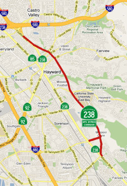
![[238 Hayward Loop]](maps/238-hayward-loop.jpg) In August 2012, updates were provided on the Route 238
corridor project in Hayward. The goal of the project is construction of a
"loop" to speed traffic through downtown Hayward to link I-580 and Route 238. As of August 2012, the project ws roughly two-thirds complete. LED
streetlights have been installed for almost the full length of Foothill
Boulevard from I-580 to Mission Boulevard. Video-monitored traffic signals
have been activated at several intersections. The northern portion of the
Foothill corridor is paved, with new sidewalks and a median. Near the
southern end of the project, a section of Mission is nearly finished, with
a repaved road and new sidewalks, lights and median. The project has
encountered delays due to unexpected problems -- among them a Mission
Boulevard sidewalk that was really a basement roof, the discovery of
abandoned wells and underground gas storage tanks. In addition, rain
delays during the wet winter of 2010 also pushed the project back. The
heart of the project is a "loop" of one-way streets through downtown. This
has involved torn-up sidewalks and intersections, but completion is in
sight. Several intersections along Foothill in the loop are still torn up,
awaiting the arrival of huge custom-made traffic signal bridges that will
span the boulevard. After they are installed, the one-way loop will be go
into effect. Old signals will be removed, and roads in the downtown will
be ground down and leveled out. Paving downtown streets, one of the final
steps, probably won't happen until May 2013.
In August 2012, updates were provided on the Route 238
corridor project in Hayward. The goal of the project is construction of a
"loop" to speed traffic through downtown Hayward to link I-580 and Route 238. As of August 2012, the project ws roughly two-thirds complete. LED
streetlights have been installed for almost the full length of Foothill
Boulevard from I-580 to Mission Boulevard. Video-monitored traffic signals
have been activated at several intersections. The northern portion of the
Foothill corridor is paved, with new sidewalks and a median. Near the
southern end of the project, a section of Mission is nearly finished, with
a repaved road and new sidewalks, lights and median. The project has
encountered delays due to unexpected problems -- among them a Mission
Boulevard sidewalk that was really a basement roof, the discovery of
abandoned wells and underground gas storage tanks. In addition, rain
delays during the wet winter of 2010 also pushed the project back. The
heart of the project is a "loop" of one-way streets through downtown. This
has involved torn-up sidewalks and intersections, but completion is in
sight. Several intersections along Foothill in the loop are still torn up,
awaiting the arrival of huge custom-made traffic signal bridges that will
span the boulevard. After they are installed, the one-way loop will be go
into effect. Old signals will be removed, and roads in the downtown will
be ground down and leveled out. Paving downtown streets, one of the final
steps, probably won't happen until May 2013.
(Source: Oakland Tribune, 8/1/2012)
In October 2017, the CTC authorized relinquishment of right of way in the city of Hayward on Route 238 (Mission Boulevard) from the Hayward city limits to Industrial Parkway (04-Ala-238-PM 7.8/9.3), under terms and conditions as stated in the relinquishment agreement dated August 29, 2017, determined to be in the best interest of the State. Authorized by Chapter 451, Statutes of 2015, which amended Section 538 of the Streets and Highways Code.
In February 2022, the LA Times had an article on the scars left by
unbuilt freeways, with a particular emphasis on the "scar" left by the
unbuilt Hayward Freeway. It noted that in Hayward, many tenants along the
five-mile abandoned freeway corridor bought their homes. New neighbors and
property flippers renovated battered bungalows that the state neglected to
maintain. On the once-vacant land, construction is underway for what could
be 1,500 new homes. It also noted that blight and resentments linger. Some
tenants feel embittered that they were forced to leave houses because they
couldn’t afford required repairs and upgrades. And more than a
decade after the state officially killed the freeway and ordered Caltrans
to sell the properties, some remain squalid, with doors and windows
boarded up and empty land overrun by weeds and trash. The road saga began
in the early 1960s when state highway officials wanted to run a
north-south freeway through the city to free up traffic downtown. Over a
few short years, the state acquired more than 300 acres in and around
Hayward, including more than 300 homes, to get ready. But public sentiment
soured quickly. By the late 1960s, revolts against freeways erupted over
the environmental destruction and community division they were causing.
Activists and homeowners in Hayward and Union City, the community just
south, sued to stop the Route 238 Freeway under new federal environmental
and housing laws passed in response to the outcry. Their victory in 1971
halted all property acquisition, a death knell for the project. However,
tt took until 2010 — more than 50 years after planners first dreamed
up the Route 238 Freeway — for the project to finally end. A legal
settlement ratified that year gave tenants the chance to own the homes
they’d be living in. During the period between 1971 and 2010, state
and local officials concocted various schemes to construct some version of
the freeway, but every idea got tied up in litigation or ran out of money.
Tenants moved into the freeway properties, attracted by low rents. Houses
deteriorated as the state skimped on maintenance. The worst of them were
boarded up, attracting squatters and thieves, creating eyesores along
entire blocks. Residents pushed back to no avail. In the early 1990s, one
tenant activist died in a house fire after years of complaints about his
home’s condition. Post-2010, the state agreed to let Hayward sell
the large parcels on its behalf, with the city retaining any profits in
deals with developers. Plans call for a mix of apartments, condominiums
and single-family homes totaling 1,500 new houses, with more than a
quarter reserved for low-income residents. Each developer must link into a
hiking trail that will run the entire freeway corridor, and the city
already is using some of the proceeds to bolster homelessness services.
Additional Reference: "The Rise and Fall of Hawyard's Route 238 Bypass".
(Source: LA Times, 2/21/2022)
Southern Crossing Approach / Southern Crossing
Note: For more information on the Southern Crossing, see I-380.
According to the 2013 Traversable Highways report, the segment between I-880 and Route 61
is unconstructed; the traversable route is Lewelling Blvd. There are not
plans to adopt a route in this area. Regarding Route 61, the Traversable
Highways report notes that with the demise of the Southern Crossing
Project plans for the construction of Route 61 were suspended.
One article, discussing unbuilt Bay Area highways, noted: "If it is ever
built, Route 238 would be the eighth Bay Area bridge. It would have
connected to Route 380 right here near SFO, and then continually along
this route all the way to Pacifica." This is a reference to the "Southern
Crossing", discussed in more detail with I-380, that would have been
constructed across the Bay, creating a connection essentially between
I-380 and I-580.
(Source: KGO 7, 11/13/2018)
 Pre 1964 Signage History
Before the 1964 signed/legislative route alignment, this route was signed as Alternate US 101. It was LRN 5, defined in 1909, between I-680 in Fremont and I-580 near Hayward; it was signed as Route 9 before 1964. The route was LRN 228, defined in 1947, between I-580 and Route 61. This is signed as I-238 between I-580 and I-880, and unsigned for the remainder of the route.
Tom Fearer did a bunch of research on the history of the routing for his
blog on I-238, based on material on this site combined with the state
highway maps. He noted the following: The original signed highway
designation on the Route 238 corridor was US 48 between San Jose and
Hayward. US 48 was assigned when the US Route system was implemented in
1926. US 48 entered downtown Hayward westward likely on Castro Valley
Road. US 48 likely followed Foothill Boulevard and A Street to Mission
Boulevard in downtown Hayward. US 48 likely turned south on Mission
Boulevard towards San Jose. US 48 followed Mission Boulevard south to Warm
Springs where it turned south on Warm Springs Boulevard. In Milpitas US 48
crossed the rails to Main Street which became Oakland Road. In San Jose,
US 48 likely followed 13th Street and Santa Clara Street to US 101. This
designation lasted to about 1929 when US 101 was split around San
Francisco Bay into US 101W and US 101E. When US 101E was assigned it took
over the route of US 48 from Hayward to San Jose. The next signage along
the Route 238 corridor around 1935 was Route 17 from downtown San Jose
northward to the junction of Warm Springs Boulevard and Mission Boulevard.
Route 17 then split northward towards Oakland on Warm Springs Boulevard
whereas Mission Boulevard towards Hayward remained unsigned. By 1940,
signage for Route 21 was added and was routed on the Route 238 corridor on
Mission Boulevard between Route 17 in Warm Springs to what is now I-680
near Mission San Jose. By 1948, signed Route 9 was extended to US 50 in
Hayward on the Route 238 corridor. Route 9 multiplexed Route 17 to Warm
Springs and Route 21 to Mission San Jose. By 1955, the Nimitz Freeway was
completed north of San Jose to Warm Springs. As a result, Route 17/Route 9
were moved to the new freeway alignment, and the previous surface
alignment on the Route 238 corridor from San Jose to Warm Springs became
an unsigned part of LRN 5 again. During the 1964 Highway Renumbering Route 238 was created out of what was largely Route 9 between Hayward and
Mission San Jose. Route 680 is shown on the 1964 State Highway Map between
Mission San Jose and Warm Springs whereas Warm Springs to San Jose is
shown as Route 17. Route 238 was also consolidated with LRN 228 which was
the future I-238 corridor.
(Source: Gribblenation Blog/Tom Fearer: Interstate 238; ..., 2/15/2019)
Discussions on ꜲRoads noted
that the east-west portion of I-238 (LRN 228) was built as full freeway at
the same time that the rest of US50 through Dublin Canyon (now I-580) was
widened to four lanes; it predates the US 50 (I-580) leg up into San
Leandro and Oakland that didn't reach Castro Valley until 1964-65.
Aside from being narrow, the biggest problem with "old" Route 238 is that
there was no direct connection between it and Route 17 (I-880) to the
south, likely on the assumption that Route 92 was originally supposed to
be freeway to the north-south segment of Route 238 between Hayward and
Fremont—and thus this movement would not have been needed. At
this time, it was necessary to exit at Washington Ave. and do a short
surface street maneuver to connect to Route 17. A direct northbound
Route 17 (I-880) to Route 238 ramp was added in the early 1980's.
The Route 238 to SB I-880 connection was added as part of the overhaul of
the entire I-238 segment (and I-580 to Palomares Canyon), which included
widening to add lanes, provision of the central median r/w for BART, and
reconstructing the interchange with I-580.
(Source: HeyNow415 on AARoads, “Re: Was US 101 south of Crescent it’s in Rockslide?”, 9/13/2021)
Portions of Route 238 were originally called the "Llewelling Blvd"
Freeway. The original plans were to extend this westward to the Route 61
freeway. Later plans were to have extended this across the bay to meet US 101 at the I-380 interchange north of the airport.
(Source: Scott "Kurumi" Oglesby)
 Status
After the new I-680 alignment was finalized but until the freeway was constructed, Oakland Road and Main Street were signed as Route 238, since that portion of Mission Blvd south of the present terminus of Route 238 was signed as Route 238 to Warm Springs. Today's I-880 freeway was signed as Route 17 and Temporary I-680 north of US 101 to the junction of Route 262 and Route 17 and Temporary I-280 south of US 101 to the junction of US 280. Note that Mission Blvd crosses I-680 twice. At the first (northern) crossing it is signed as Route 238 and this is the present terminus of Route 238. At the second (southern) crossing it is signed as a connection to I-880; this is the eastern terminus of (unsigned) Route 262. Also, the city of Milpitas built a new alignment for Main Street, so present-day maps do not show how Oakland Road connected with Mission Blvd in Warm Springs via Main Street.
When I-680 was built in the hills through Fremont's east side in the 1963-1964, an overpass and roadway was also constructed heading northwest where I-680 now turns east up through Mission Pass, between the Washington Boulevard and Auto Mall Parkway exits. That section, about 1,000 feet long, was the start of the aborted Mission Freeway that was to have run northwest under Lake Elizabeth through the middle of Fremont and Union City to connect with I-580 in Hayward. These plans were scuttled in the 1970s. This "bridge to nowhere" was demolished in 2002 to accomodate widening of I-680. However, the Caltrans Bridge Log dates the bridge as 1971, and refers to it as "FUTURE 238/680".
Route 238 was widened from four to six lanes from south of Mowry Avenue to north of Niles Canyon Road in Fremont (~ ALA 3.258 to ALA 3.777). Construction began in 2002 and is completed in summer 2005. The project includes the widening the Alameda Creek Bridge and replacing two railroad bridges. This project follows other recent Route 238 widening projects—between Decoto Road and Whipple Road in Union City (from four to six lanes)—and in the vicinity of Industrial Blvd in Hayward. Mitigation planting was approved in July 2010.
In May 2010, the CTC accepted for future consideration of funding the FEIR for a project to covert downtown Hayward into a loop of one-way streets. This project will add peak hour travel lanes, improvements at major intersections along the route, pedestrian and bicycle improvements, and landscaping.
In October 2020, the CTC authorized relinquishment of right of way,
consisting of relocated or reconstructed county roads and frontage roads,
in the County of Alameda along Route 238 on 172nd Avenue (San Pedro
Avenue), Rogerio Street (Rogerio Avenue), 173rd Avenue (San Remo Avenue),
and Esteban Street (Esteban Avenue) (04-Ala-238-PM R14.8/15.0, 3
segments), under the terms and conditions as stated in the freeway
agreement dated October 20, 1992. The County, by Resolution No.
2020-277 dated June 30, 2020 and by letter dated August 5, 2020, agreed to
waive the 90-day notice requirement and accept title upon relinquishment
by the State.
(Source: October 2020 CTC Agenda, Agenda Item 2.3c)
In January 2011, the CTC authorized relinquishment of right of way in the county of Alameda along Route 238, on Westerman Court, Morrill Street, and Langton Way, consisting of collateral facilities (~ ALA 15.318).
In March 2014, the CTC authorized vacation of right of way in the county of Alameda along Route 238 at Westerman Court (~ ALA 15.318), consisting of highway right of way no longer needed for State highway purposes. The County, having no desire to retain interests in the area, and to clarify title, quitclaimed all rights, title and interests to the State.
The SAFETEA-LU act, enacted in August 2005 as the reauthorization of TEA-21, provided the following expenditures on or near this route:
In November 2006, Caltrans began a project to widen I-238 between I-880 and I-580 to three lanes in each direction. The project is planned to take about four years and be complete in 2010.
 Naming
Historically, this route is close to the original "El Camino Real" (The Kings Road). A portion of this route has officially been designated as part of "El Camino Real by Assembly Bill 1707, Chapter 739, on October 11, 2001.
 Interstate Submissions
 The portion from Fremont to Hayward was submitted for inclusion in the interstate system in 1968; not accepted. A portion of this route is
designed as I-238 for continuity of numbering; it is non-chargeable
interstate with the I- designation approved by AASHTO.
The portion from Fremont to Hayward was submitted for inclusion in the interstate system in 1968; not accepted. A portion of this route is
designed as I-238 for continuity of numbering; it is non-chargeable
interstate with the I- designation approved by AASHTO.
 Exit Information
 Other WWW Links
 Classified Landcaped Freeway
The following segments are designated as Classified Landscaped Freeway:
| County | Route | Starting PM | Ending PM |
| Alameda | 238 | 14.54 | 16.70 |
 Freeway
[SHC 253.1] Entire route. Added to the Freeway and Expressway system in 1959.
StatusThere is supposedly at least one study attempting to connect this to the "Southern Crossing".
 National Trails
 This route is part of the De Anza National Historic Trail.
 Statistics
Overall statistics for Route 238:
 Pre-1964 Legislative Route
In 1957, Chapter 26 defined LRN 238 “to extend from a point on [LRN 4] south of Bakersfield to a point on [LRN 7] near Woodland, on a route along the westerly side of the San Joaquin Valley to be selected by the California Highway Commission, which route may include all or portions of any existing state highway route or routes”.
This route runs from LRN 4 (US 99; the present-day I-5/Route 99 junction) S of Bakersfield to LRN 7 (US 40; present-day I-80) near Woodland. This is the "Western Alignment", and is present-day I-5.
© 1996-2020 Daniel P. Faigin.
Maintained by: Daniel P. Faigin
<webmaster@cahighways.org>.
 Route 237
 Route 239