
 California Highways:
Click here for a key to the symbols used. An explanation of acronyms may be found at the bottom of the page.
 Routing
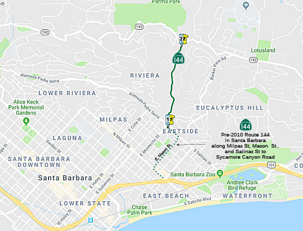 From Alameda Padre
Serra in Santa Barbara to Route 192 via Sycamore Canyon.
From Alameda Padre
Serra in Santa Barbara to Route 192 via Sycamore Canyon.
(b) Upon a determination by the commission that it is in the best interests of the state to do so, the commission may, upon terms and conditions approved by it, relinquish Route 144 to the City of Santa Barbara, if the city has agreed to accept it. The relinquishment shall be effective on the day immediately following the commission's approval of the terms and conditions.
(c) This section shall remain in effect only until the date the relinquishment authorized under subdivision (b) becomes effective, and as of that date is repealed, unless a later enacted statute, which is enacted on or before that date, deletes or extends that date.
(d) The relinquished former portion of Route 144 in the City of Santa Barbara between Route 101 and Alameda Padre Serra is not a state highway and is not eligible for adoption under Section 81. For that relinquished former portion of Route 144, the City of Santa Barbara shall maintain signs directing motorists to the continuation of Route 144.
 Post 1964 Signage History
As defined in 1963, this route was "Route 101 near Santa Barbara to Route 192 via Sycamore Canyon."
A 1991 Thomas Brothers Map shows the route running from US 101 along Milpas to Mason Street, up Mason Street to Salinas Ave, and then up Salinas to Sycamore Canyon.
In 1992, Chapter 1243 changed the origin to be "Route 101
near in Santa Barbara to …"
In 1999, SB 557 Chapter 99 (July 13, 1999) authorized the California Transportion Commission to reliquish Route 144 to the city of Santa Barbara. Once that is approved, the route is reliquished as of the following day. The relinquishment was on the agenda for the California Transportation Commission in June 2000, Agenda Item 2.3c, for Santa Barbara PM 0.0-0.9.
In 2010, SB 1318, Chapter 421 (9/29/10) changed the route definition:
"From
Route 101 Alameda Padre Serra in Santa Barbara to..."
 Pre 1964 Signage History
This appears to have been unsigned before 1964. It was segment (2) of LRN 80, defined in 1933.
Route 144 was not defined as part of the initial state signage of routes in 1934. It is unclear what (if any) route was signed as Route 144 between 1934 and 1964.
 Status
In January 2013, the CTC authorized relinquishment of right of way in the city of Santa Barbara along Route 144 just north of Ranchito Vista Road (~ SB 1.782), consisting of highway right of way no longer needed for State highway purposes. The City of Santa Barbara was given a 90-day notice of intent to vacate, without protesting such action.
 Other WWW Links
 Statistics
Overall statistics for Route 144:
 Pre-1964 Legislative Route
In 1933, Chapter 767 defined the route from "Cummings Valley State Institution to [LRN 58] near Old Town" as part of the state highway system. In 1935, this was added to the highway code as LRN 144 with that definition.
In 1949, Chapters 909 and 1467 changed "Old Town" to "Tehachapi".
This route runs from Route 58 to the California Correctional Institution, formerly the Cummings Valley State Institution. This is present-day Route 202.
© 1996-2020 Daniel P. Faigin.
Maintained by: Daniel P. Faigin
<webmaster@cahighways.org>.
 Route 143
 Route 145