
 California Highways:
Click here for a key to the symbols used. An explanation of acronyms may be found at the bottom of the page.
 Routing
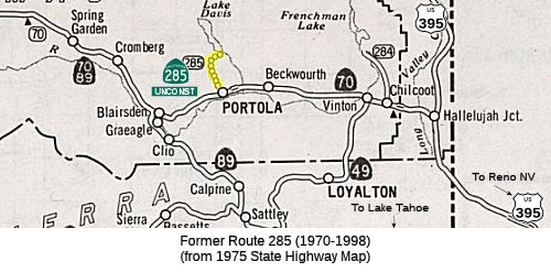 No current routing.
 Post 1964 Signage History
In 1970, Chapter 1473 defined Route 285 as “Route 70 on West Street in Portola northwesterly to the north city limits, then to Lake Davis via Humbug Canyon, and then easterly to Grizzly Reservoir via the south shore of the lake.”
In 1998, AB 2132, Chapter 877, signed September 26, 1998 deleted the routing. The route was never constructed. According to the Caltrans photolog, the old alignment for Route 285 essentially is exactly the same as existing West Street (in Portola) and Lake Davis Road northeast to Grizzly Road just northeast of the Big Grizzly Creek via Humbug Canyon. The 4.8 miles from Portola were constructed in 1972 (22' traveled way, 3' shoulders, 6" base, and 2" asphaltic concrete). There were problems with the right of way and drainage.
 Status
The 2013 Traversable Highways report notes that the unconstructed portion is from Route 70 in Portola to Lake Davis (7.5 mi). The closest approximation is West Street in Portola and via Humbug Canyon - 4.8 miles from Portola were constructed in 1972 (22' traveled way, 3' shoulders, 6" base and 2" asphalt concrete). There are problems with right of way and drainage. The road was not constructed to State standards.
 Other WWW Links
 Statistics
Overall statistics for Route 285:
 Pre-1964 Legislative Route
In 1959, Chapter 1062 defined LRN 285 as “[LRN 241] south of [LRN 200] to [LRN 282] near the Sweetwater Reservoir”. This was 1964-1994 Route 157 from I-805 south of Route 94 to Route 125 near the Sweetwater Reservoir.
© 1996-2020 Daniel P. Faigin.
Maintained by: Daniel P. Faigin
<webmaster@cahighways.org>.
 Route 284
 Route 286