
 California Highways:
Click here for a key to the symbols used. An explanation of acronyms may be found at the bottom of the page.
 Routing
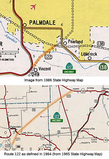 From Route 14 south of Palmdale to Route 138.
Note: This routing is unconstructed. It does not correspond to Pearblossom Highway between Route 14 and Route 138, despite what Google maps says. That segment of Pearblossom Highway is LA County maintained.
 Post 1964 Signage History
As defined in 1963, Route 122 ran from "Route 249 south of Palmdale northeasterly to Route 58." In some 1963 planning maps, this route appears to have started at the Route 196/Route 249 junction, with Route 196 continuing N as Route 249, and Route 249 continuing E as Route 122. At this time, Route 58 was planned as freeway, as was Route 122.
Regarding this routing, Sparker noted on AAroads: (more details may be found with Route 249):
(Source: Scott Parker on AARoads, "Re: Metro Debuts New Express Lanes On 110 Freeway", 7/12/2018)
Route 122 (the portion extending out into the desert) would stay on the surface (ridge or cliffside) until that became impractical, then tunnel to the next feasible surface segment, repeating until the range was surmounted. The portion of Route 249 connecting (after the interchange with the tunnel-laden corridor) to Angeles Crest Highway/Route 2 was designated as Route 196. Route 249 essentially followed the Angeles Forest Highway from Route 2 west of Mt. Wilson north to Route 14 near Vincent (the surface routing is Los Angeles County Sign Route N3). Sparked noted that the corridor with the Ells and other tunnels would have likely, if completed as planned, been part of Route 122, which descended to the desert between Palmdale and Pearblossom, crossed Route 138, and struck out NE into the desert, skirting the SE corner of Edwards AFB and terminating at Route 58 west of Hinkley, however, that was never part of the legislative definition of Route 2 or Route 122. Sparker noted that while the map shows the Route 122 corridor as serving SE Palmdale by tracing Pearblossom Highway west of Route 138 (which it did post 1965), the Division/Caltrans documents invariably show it several miles east of there. It was intended that after going through the first couple of tunnels, Palmdale-bound traffic would segue onto Route 249 at the mountaintop interchange, while traffic ostensibly heading for Barstow and points beyond would remain on the diagonal desert corridor. The concept here was simple -- central L.A. to Barstow via the most direct feasible route.
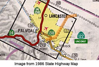
In 1965, Chapter 1371 changed the origin to be "Route 14 south of Palmdale", deleting the segment from Route 249 N of La Cañada to Route 14. This eliminated Route 196, moved the start of Route 122 to the Route 14/Route 249 junction. This junction is where Pearblossom Highway exits Route 14, so Route 122 would have run from that junction roughly to around the SE corner of Edwards AFB, near Ave E and the SBD county line. From the Route 14/Route 249 junction, it would have continued mostly northeast to end at Route 48 (now Route 138) several miles north of Hi Vista just shy of the Los Angeles/San Bernardino County line. According to the photolog, the current planned Route 122 would follow Pearblossom Highway to 25th Street, but then diverged from the historical plan after crossing existing Route 138 near 50th Street and Palmdale Boulevard. Route 122 now is planned to continue northbound paralleling 50th Street before turning northeast a mile or so from Route 48, ending at Route 48 west of Redman (just south of the Los Angeles/Kern county line and the south boundary of Edwards AFB).
In 1972, Chapter 1216 split the route into two segments: "(a) Route 14 south of Palmdale to Route 138. (b) Route 138 northeasterly to Route 58."
 Pre 1964 Signage History
This was part of LRN 266, defined in 1959.
 Status Post 1964 Signage History
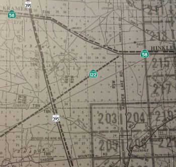 As defined in 1963, Route 122 ran from "Route 249 south of Palmdale northeasterly to Route 58." In some 1963 planning
maps, this route appears to have started at the Route 196/Route 249
junction, with Route 196 continuing N as Route 249, and Route 249
continuing E as Route 122. At this time, Route 58 was planned as freeway,
as was Route 122.
As defined in 1963, Route 122 ran from "Route 249 south of Palmdale northeasterly to Route 58." In some 1963 planning
maps, this route appears to have started at the Route 196/Route 249
junction, with Route 196 continuing N as Route 249, and Route 249
continuing E as Route 122. At this time, Route 58 was planned as freeway,
as was Route 122.
In 1965, Chapter 1371 changed the origin to be "Route 14 south of Palmdale". In 1972, Chapter 1216 split the route into two segments: "(a) Route 14 south of Palmdale to Route 138. (b) Route 138 northeasterly to Route 58."
In 1976, Chapter 1354 split (b) again into "(b) Route 138 to Route 48. (c) Route 48 northeasterly to Route 58."
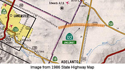
According to Tom Fearer, by 1981 the planned route of Route 122 east of
Palmdale/Lancaster changed. Originally Route 122 was planned to head
directly northeast to Route 58. The 1981 Caltrans Map shows Route 122 taking a northward jog to planned CA 48
and then eastern turn towards it's originally projected alignment.
This change in planned routing of Route 122 likely was done to service
Edwards Air Force Base.
(Source: Tom Fearer, Gribblenation Blog, "Paper Highways of the Mojave Desert and San Gabriel Mountains; CA 48 (ii), CA 122, CA 196, and CA 249")
Planned as freeway in 1965; never constructed.
Pre 1964 Signage HistoryThis segment was proposed LRN 266 (defined in 1959) in 1963.
Status The 2013 Traversable Highways report identifies 50th St. East as the traversable local routing. There are no plans for improvement.
 From Route 48 northeasterly to Route 58.
Post 1964 Signage HistoryAs noted above, the 1963 definition of Route 122 ran from "Route 249 south of Palmdale northeasterly to Route 58." In 1965, Chapter 1371 changed the origin to be "Route 14 south of Palmdale". In 1972, Chapter 1216 split the route into two segments: "(a) Route 14 south of Palmdale to Route 138. (b) Route 138 northeasterly to Route 58."
In 1976, Chapter 1354 split (b) again into "(b) Route 138 to Route 48. (c) Route 48 northeasterly to Route 58."
Pre 1964 Signage HistoryThis segment was proposed LRN 266 in 1963.
Status There is no traversable local highway. There are no plans to upgrade this. For the SBD portion, the 2013 Traversable Highways report
notes "District Corridor Review" No local roads adequately fit the
description of a traverasable highway.
Pre 1964 Signage HistoryRoute 122 was not defined as part of the initial state signage of routes in 1934. It is unclear what (if any) route was signed as Route 122 between 1934 and 1964.
 Other WWW Links
 Statistics
Overall statistics for Route 122:
 Freeway
[SHC 253.1] Entire route.
 Pre-1964 Legislative Route
In 1933, Chapter 767 defined the route from "Fresno-Tracy West Side Highway near Newman to [LRN 4] near Livingston" as a state highway. In 1935, this was added to the highway code as LRN 122, with the definition:
In 1937, Chapter 36 moved the routing away from River Road, making it "[LRN 41] at Gustine to [LRN 4] near Merced via the John C. Fremont Ford Road".
In 1959, Chapter 1062 extended the origin to Route 238, and eliminated the specific routing, giving: "[LRN 238] near Gustine to [LRN 4] near Merced".
This was the route from I-5 near Gustine to US 99 near Merced. It is present-day Route 140. The design of the highway was approved in 1953, and it was constructed in 1954.
© 1996-2020 Daniel P. Faigin.
Maintained by: Daniel P. Faigin
<webmaster@cahighways.org>.
 From Route
  Route 121
 Route 123