
 California Highways:
Click here for a key to the symbols used. An explanation of acronyms may be found at the bottom of the page.
 Routing
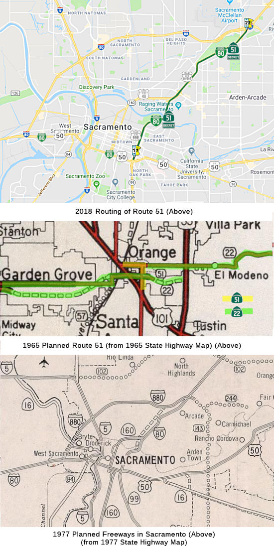
 From Route 50 in Sacramento to Route 80
east of Sacramento. Per SHC Section 351.1: Route 51 is signed as
Interstate Business Loop 80.
From Route 50 in Sacramento to Route 80
east of Sacramento. Per SHC Section 351.1: Route 51 is signed as
Interstate Business Loop 80.
 Post 1964 Signage History
 In 1963, Route 51 was defined to run from Route 5 to Route 5 near
Santa Ana. That route was part of LRN 2. It ran along Orangewood Avenue
from I-5 east to Main Street, passing south of what is now Edison Field,
and then along Main Street south back to I-5 (thanks to Calvin Sampang for
hunting that out). The routing was deleted in 1965 by Chapter 1372.
In 1963, Route 51 was defined to run from Route 5 to Route 5 near
Santa Ana. That route was part of LRN 2. It ran along Orangewood Avenue
from I-5 east to Main Street, passing south of what is now Edison Field,
and then along Main Street south back to I-5 (thanks to Calvin Sampang for
hunting that out). The routing was deleted in 1965 by Chapter 1372.
 In 1981, Chapter 292 defined the current routing. This is a former segment of I-80 that was bypassed by new construction for I-80. The
original plan, however, was to have this segment, as well as the segment
from US 50 to I-80 (legislatively US 50, signed Business Route 80) upgraded to proper
interstate standards, and have the current I-80 routing be I-880. But that
didn't happen (see I-80 for details), thus resulting in the creation of
Route 51 (Business Route 80).
In 1981, Chapter 292 defined the current routing. This is a former segment of I-80 that was bypassed by new construction for I-80. The
original plan, however, was to have this segment, as well as the segment
from US 50 to I-80 (legislatively US 50, signed Business Route 80) upgraded to proper
interstate standards, and have the current I-80 routing be I-880. But that
didn't happen (see I-80 for details), thus resulting in the creation of
Route 51 (Business Route 80).
With respect to this segment, during the 1964 State Highway renumbering
Route 80 was assigned onto US 99E to US 99, indicating it was planned as
the future route of I-80, with future I-880 (current I-80) bypassing
Sacramento to the north. By 1965 a new freeway grade is completed to US 99
and I-80 is co-signed into Sacramento on US 99E. In 1966 a new planned
alignment of I-80 appears next US 99E/I-80 from the American River north
to the planned I-880. In 1967 US 40, US 99E, and US 99W all disappear from
California. US 99 is reassigned as CA 99. By 1969, I-80 is shown complete
through downtown Sacramento but the former alignment of US 99E is shown as
Temporary I-80. In 1981 the planned alignment of I-80 was cancelled by the
State Legislature (and the planned I-880 became I-80). This action led to
the creation of Route 51 and the legislative definition that it must be
signed as the Business Route 80. On the 1982 state highway map, I-80 is shown on the
(Legislative) Route 51 routing, and I-880 is shown on (Legislative) Route 80 routing. By 1986, Business Route 80 appears on (Legislative) Route 51 (with a loop
back to I-80 along (Legislative) Route 50 (US 50)), and I-880 has become
I-80. By 2015, Caltrans was deemphasizing Business Route 80, and the (Legislative)
Route 50 section was signed as US 50; however, thanks to the legislative
requirement Route 51 was still signed as Business Route 80. This paragraph was
condensed from Tom Fearer's blog post on the subject; said blog posts has links to the state highway maps and annotated insets showing all of this.
(Source: Gribblenation Blog: California State Route 51; failed Interstate 80 on the Capitol City Freeway, the I–80 Business Loop, and former US 40/99E, 10/18/2018)
 Pre 1964 Signage History
Before the construction of the US-50 and I-80 freeways through Sacramento, this route was:
What eventually became Route 51 was originally defined as a State Highway
during the 1909 First State Highway Bond Issue. Said highway was to run
from Sacramento north to the Oregon State Line and eventually would be
assigned LRN 3. LRN 3 north out of Sacramento ran from L Street; along
16th Street over the American River to Del Paso Boulevard, then along Del
Paso Boulevard to El Camino Avenue to Auburn Boulevard, and then along
Auburn Boulevard towards Roseville. When the US Route system was finalized
in 1926 the route of LRN 3 north out of Sacramento was assigned US 40 and
US 99E. US 40/US 99E can be seen on LRN 3 north out of Sacramento in the
1934 City Insert for Sacrament on the State Highway Map. In 1944 the first
major change to LRN 3 in the Sacramento Area appears with a planned bypass
of North Sacramento. By 1948 the North Sacramento Bypass was completed.
The North Sacramento Bypass would eventually became part of Route 160 on
the North Sacramento Freeway in addition to Route 51 on the Capitol City
Freeway north of the American River. By 1951 a new planned route for US 99E to cross the American River appears on the City Insert of Sacramento.
This newly planned route of US 99E would be assigned to pre-existing LRN 98. By 1955 a fully planned routing of US 99E over the American River to
US 50 and the mainline US 99 appears on the City Insert for Sacramento. By
1956 the new US 99E alignment was completed from US 40 north of the
American River south to US 99. US 99E utilized 29th and 30th Street in
one-way configurations to reach US 99. This paragraph was condensed from Tom Fearer's blog post on the subject; said blog posts has links to the state
highway maps and annotated insets showing all of this.
(Source: Gribblenation Blog: California State Route 51; failed Interstate 80 on the Capitol City Freeway, the I–80 Business Loop, and former US 40/99E, 10/18/2018)
 Adoption of the route for the first segment of the Elvas Freeway was sometime in 1949 or early 1950.
The freeway connected C Street with the North Sacramento Freeway (Route 160, as I-80 came much later). The first project would be the construction
of the American River Bridge (which ended up being completed in 1954). The
project was budgeted in the FY50-51 budget, and freeway construction began
in May 1950, but delays due to material shortages and weather put off
major construction until 1952. The first 2.9 mile 4-lane stretch opened on
May 12, 1955.
Adoption of the route for the first segment of the Elvas Freeway was sometime in 1949 or early 1950.
The freeway connected C Street with the North Sacramento Freeway (Route 160, as I-80 came much later). The first project would be the construction
of the American River Bridge (which ended up being completed in 1954). The
project was budgeted in the FY50-51 budget, and freeway construction began
in May 1950, but delays due to material shortages and weather put off
major construction until 1952. The first 2.9 mile 4-lane stretch opened on
May 12, 1955.
(Source: Not identified, but likely late 1949 or early 1950, via
Joel Windmiller, 2/1/2023)
The American River Bridge (Bridge #24-0003) is a multi-span bridge built
in 1954 with two lanes in each direction. In 1966, an additional lane was
added in each direction in the median with a closure pour. The state route
was formerly known as I-80 and was changed to Route 51 in the
mid-1970’s. The American River Bridge was seismically retrofitted in
1977 at various locations and in 1988, when span 1 and 2 girders were
strengthened with pre-stressing.
(Source: American River Bridge Deck Replacement EIR, Dec 2020)
 Route 51 was not defined as part of the initial state signage of
routes in 1934. It is unclear what (if any) route was signed as Route 51
between 1934 and 1964.
Route 51 was not defined as part of the initial state signage of
routes in 1934. It is unclear what (if any) route was signed as Route 51
between 1934 and 1964.
 Status
Business Loop 80 (Cap City Freeway) vs. Route 51
This is the existing section of Business Loop 80 between the US-50/Route 99 interchange and I-80. Construction was done on a section near the north end of the I-80/Business Route 80 interchange to replace what is known as the Elvas Freeway, since it is currently only a two lanes in each direction freeway for a portion near Cal Expo. The section that was built is currently being used by Sacramento RTD to operate their light rail system. This is not consistantly signed, although you can see the designation on the mileage markers.
In September 2015, it was reported that Caltrans was resigning the routes in Sacramento to de-emphasize Business Route 80 except where legislatively mandated (i.e., along Route 51). This is based on a desire to simplify things and just sign US 50 as one route and not a multitude of routes, especially as more and more people are referring to the joint US 50/Business Route 80 multiplex as simply US 50. However, the legislative description for Route 51 mandates that it be signed as Business Route 80; the legislative description of Route 50 includes no such requirement. So basically, Business Route 80 is becoming a Business spur, but there's no plans to update the signing to reflect such a change. The Capital City Freeway name will be emphasized on Route 51 and only Route 51.
Capital City Freeway Project
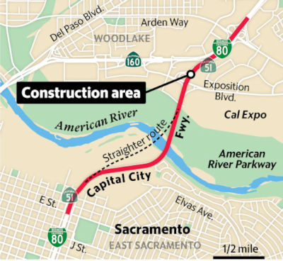
In September 2017, Caltrans launched a public webiste for the Capital City Freeway Project. The primary objective of the proposed $575 million project from J Street to Exposition Boulevard over the American River is to extend the existing bus/carpool lanes, widen about a three-mile stretch of highway to accommodate new bus/carpool lanes for both directions, construct auxiliary lanes and construct a new Class I bike path on the American River Bridge. Route 51 (Business Route 80) and adjacent surface streets have become the most congested corridor in the region. In 2016, the Cap City Freeway experienced more than 2,050,000 annual hours of delay at a $27.5 million cost to users and had five of the region’s top 10 bottlenecks. The project is currently in the Engineering and Environmental Studies phase.
In August 2013, it was reported that Caltrans is pursuing plans to close the E Street on ramp in east Sacramento (apx. 51 SAC 1.454). This will permit them to squeeze another mile long lane onto the freeway from J Street to the bridge over the American River. The eastbound side of the freeway currently drops from five lanes to three in the space of a quarter mile near E Street, making that stretch of freeway the worst pinch point in the region. The reconfiguration, considered minor at a cost of $6 million, would allow the state to extend the fourth lane another mile to nearly the foot of the American River bridge. Although Caltrans has legal authority to close the ramp, Jones said the agency is seeking input from the city and will check in with area residents as well. Caltrans ultimately will have to do an environmental analysis to justify the change. The ramp closure date is likely three years away, officials estimate.
American River Bridge Vicinity Improvements (PPNO 6402 03-Sac-51 2.0/3.5, PPNO 6409 03-Sac-51 ~1.04/4.07)
In December 2015, it was reported that Caltrans has
begun laying the groundwork for a $700 million freeway widening from
midtown to the junction with I-80. That includes widening the American
River bridge (apx. 51 SAC 2.696) to add a new multi-use lane in each
direction, as well as building wider shoulders for stalled cars to pull
over, a separate lane on the bridge for cyclists and pedestrians, and
other improvements. The proposed project area is 8 miles long. Caltrans
officials say the project is so big and the funding sources so uncertain
that it may not happen for a decade. A few years ago, Caltrans considered
simply closing the E Street onramp and adding a brief extra lane, based on
a traffic analysis that showed that would ease the bottleneck. But as
traffic increased post-recession, state and city officials concluded they
need to take “a much bigger bite of the apple.” Caltrans and
Sacramento planners say they expect new state transportation funds to
materialize over time, and more federal funds to be available for
multimodal projects that reduce greenhouse gas emissions and other
pollutants. SACOG this month allocated $9 million to Caltrans for project
planning. That includes defining the scope of the project, conducting
environmental studies and obtaining permits and other approvals, then
applying for grants when they become available. It also involves working
with state, federal and local agencies, advocacy groups and private
companies such as Union Pacific. The state says it is looking at expanding
in two phases. The first involves a variety of changes, most notably a new
lane in each direction from J Street on the south end to Arden Way on the
north side of the river. The second phase involves working from Arden Way
east to I-80. Buses and carpools will have exclusive rights to the new
lanes. Those high-occupancy vehicle, or HOV, lanes revert to “mixed
flow” for solo drivers to use during nonpeak hours. The state is
committed to making the rebuilt Capital City Freeway
“multimodal,” most notably by adding a bike and pedestrian
travelway on the bridge over the river, separated from cars, to connect to
existing bike trails on both sides of the river. The state also would
change freeway ramps to make them more accessible for buses and safe to
cross for cyclists and pedestrians. Caltrans, meanwhile, plans to spend
$137 million to scrape and replace the bridge deck and do other
maintenance and repair work, much like it did on the Fix 50 project last
year. That work is expected to occur in about five years and will help set
the bridge up for the widening project to come later.
(Source: Sacramento Bee, 12/25/2015)
In October 2015, the CTC approved the following long lead SHOPP funding: 3-Sac-51 2.6/3.0 Route 51 (Business Route 80) In the city of Sacramento at the American River Bridge №24-0003. Widen and replace bridge deck. PAED: 08/01/2018 R/W: 02/01/2020 RTL: 05/01/2020 CCA: 10/01/2022 Costs: $1,000K (R/W); $105,300K (C). Completion FY19/20. Supporting Costs: PA & ED $4,340K; PS & E $10,130K; RW Sup $360K; Con Sup $16,120K; Total $30,950K.
 In September 2017, it was reported that Caltrans is looking at four project
options to unclog the bottleneck near the American River Bridge (apx. 51
SAC 2.696). Three involve widening the existing bridge to add lanes. A
fourth proposal is notably different. The state is considering building a
new bridge a few hundred feet to the northwest. The new bridge alignment
would eliminate the tight freeway curve that exists on the south side of
the river, a curve that is sharper than current freeway standards advise.
But it would cut through land planned to be part of Sutter’s Landing
Regional Park. Caltrans then likely would tear down the current bridge.
But officials said there may be a scenario where that bridge would remain
in place if, for instance, Sacramento officials felt they had some other
use for it. All four options could include a reversible lane, allowing
cars to travel in different directions at different points during the day.
The expansions also would include carpool lanes and a separate area on the
bridge for bicyclists and pedestrians. The 3.4-mile work area would start
at J Street on the south side of the river and run just beyond Arden Way
on the north side. The total cost of the project likely will top a
half-billion dollars. Caltrans has launched a website to provide more information. The project is so massive that the planning, environmental studies, engineering and fund-gathering
process likely will take six years. That means construction will not begin
before 2023, and the project won’t be finished for another four
years after that. Caltrans officials had for years shied away from
committing to the project, partly because of the cost, but also because
most policymakers and planners in the Sacramento region agree that
widening freeways generally has the adverse effect of inviting people to
drive more, which ends up causing more long commutes and more congestion
in the long term. But traffic analyses by the Sacramento Area Council of
Governments indicate that unblocking the Capital City Freeway would have
positive regional effects that reach beyond Sacramento County. Funding is
not yet set. Caltrans and Sacramento planners say they expect state
transportation funds to materialize over time, and more federal funds to
be available for multimodal projects that reduce greenhouse gas emissions.
There also continues to be talk of a transportation sales tax measure on
the 2018 or 2020 ballots to raise funds for road fixes that could provide
money for the project.
In September 2017, it was reported that Caltrans is looking at four project
options to unclog the bottleneck near the American River Bridge (apx. 51
SAC 2.696). Three involve widening the existing bridge to add lanes. A
fourth proposal is notably different. The state is considering building a
new bridge a few hundred feet to the northwest. The new bridge alignment
would eliminate the tight freeway curve that exists on the south side of
the river, a curve that is sharper than current freeway standards advise.
But it would cut through land planned to be part of Sutter’s Landing
Regional Park. Caltrans then likely would tear down the current bridge.
But officials said there may be a scenario where that bridge would remain
in place if, for instance, Sacramento officials felt they had some other
use for it. All four options could include a reversible lane, allowing
cars to travel in different directions at different points during the day.
The expansions also would include carpool lanes and a separate area on the
bridge for bicyclists and pedestrians. The 3.4-mile work area would start
at J Street on the south side of the river and run just beyond Arden Way
on the north side. The total cost of the project likely will top a
half-billion dollars. Caltrans has launched a website to provide more information. The project is so massive that the planning, environmental studies, engineering and fund-gathering
process likely will take six years. That means construction will not begin
before 2023, and the project won’t be finished for another four
years after that. Caltrans officials had for years shied away from
committing to the project, partly because of the cost, but also because
most policymakers and planners in the Sacramento region agree that
widening freeways generally has the adverse effect of inviting people to
drive more, which ends up causing more long commutes and more congestion
in the long term. But traffic analyses by the Sacramento Area Council of
Governments indicate that unblocking the Capital City Freeway would have
positive regional effects that reach beyond Sacramento County. Funding is
not yet set. Caltrans and Sacramento planners say they expect state
transportation funds to materialize over time, and more federal funds to
be available for multimodal projects that reduce greenhouse gas emissions.
There also continues to be talk of a transportation sales tax measure on
the 2018 or 2020 ballots to raise funds for road fixes that could provide
money for the project.
(Source: Sacramento Bee 9/25/2017)
In January 2018, the CTC
amended the SHOPP as follows: 03-Sac-51 2.6/3.0 2.0/3.5.
Route 51/Business Route 80 In the city of Sacramento, at the American River Bridge
№ 24-0003 from north of B Street Underpass to north of Exposition
Boulevard Overcrossing. Widen and replace bridge deck. Total Cost: $137,250,000.
$163,940,000. Construction phases not yet authorized.
(Source: CTC Agenda, January 2018, Agenda Item 2.1a(1))
The 2018 STIP, approved at the CTC March 2018 meeting, appears to allocate Advance Program Development Element (APDE) funding of $7.9M for environmental and planning for PPNO 6409, Corridor Improvements, J St-Arden Way on Route 51.
In October 2018, Joe Rouse noted on AAroads: "There are
plans to widen Business Route 80 (Route 51) between E Street and roughly Arden Way.
This proposal came as a result of a study to close the E Street ontamp to
eastbound Business Route 80 and extend the 4th lane that currently drops around F
Street up to the American River Bridge. This lane drop is the worst
bottleneck on the State highways in the city. Analysis showed that this
modification would not help traffic flow and the City of Sacramento pushed
for a broader study on improvements to the whole Route 51 corridor. It led
to a proposal to widen Route 51 over its entire length but the focus
eventually was reduced to the portion between E Street and Arden Way, with
the portion between Arden and I-80 to be looked at later. These
improvements include a new bridge over the American River. The early study
looked at widening the existing bridge but there are substantial deck
repairs needed to that hurdle and so I think they came to the conclusion
that it was more cost effective to replace it. The new bridge would sit
between the SP railroad bridge and the existing bridge and would cross
over the railroad tracks, eliminating the narrow Elvas Junction underpass.
The new alignment would include HOV lanes, and an HOV flyover would be
just through the Arden interchange to avoid conflict with the Arden onramp
to westbound Business Route 80, which is a left hand entrance."
(Source: Joe Rouse on AAroads, 10/21/2018)
In March 2020, the CTC approved the 2020 STIP, which
included $8,400K in prior programming for PPNO 6409 "Corridor
Improvements, J St-Arden Way (APDE)"
(Source: March 2020 CTC Agenda, Item 4.7, 2020 STIP
Adopted 3/25/2020)
The 2020 SHOPP, approved in May 2020, included the
following Bridge Preservation item of interest (carried over from the 2018
SHOPP): 03-Sacramento-51 PM 2.0/3.5 PPNO 6402 Proj ID 0312000054 EA 3F070.
Route 51 (Business Route 80) in the city of Sacramento, at the American River Bridge
№24-0003 from north of B Street Underpass to north of Exposition
Boulevard Overcrossing. Widen and replace bridge deck. This is a
Construction Manager/General Contractor (CMGC) project. Programmed in
FY21-22, with construction scheduled to start in March 2022. Construction
capital and construction support phases are not programmed. Total
project cost is $163,940K, with $125,000K being capital (const and right
of way) and $38,940K being support (engineering, environmental, etc.).
(Source: 2020 Approved SHOPP a/o May 2020)
In December 2020, Caltrans released a video on the bridge deck replacement and widening in lieu of a public meeting. This video informed the public of the availability of the
draft environmental document. That document described the proposed project
as follows, and presented four alternatives: "Caltrans proposes to
rehabilitate the American River Bridge along Route 51 in Sacramento County
from post mile 2.0 to 3.5. The project would remove and replace the
existing concrete deck, remove and replace the steel girder
post-tensioning systems in spans 1 and 2, modify existing soundwall,
install sheet piling around piers for scour mitigation, construct concrete
catcher blocks, widen the bridge to accommodate traffic during
construction, add a Class I bike/pedestrian path, and plan for future
transportation needs on Route 51"
(Source: Caltrans Video; American Bridge River Deck Replacement Draft Environmental Document)
In March 2021, the CTC amended this project in the
SHOPP: (1d) #8. 03-Sac-51 2.0/3.5 PPNO 6402 ProjID 0312000054 EA
3F070. Route 51 (Business Route 80) In the city of Sacramento, at the American
River Bridge № 24-0003 from north of B Street Underpass to
north of Exposition Boulevard Overcrossing, at the American River
Bridge № 24-0003 and Cal Expo Undercrossing No. 24-0133.
Widen and replace bridge deck. This is a Construction
Manager/General Contractor (CMGC) project. This project was amended to
adjust the description and funding. Increase R/W capital from $2,000K to
$10,900K due to increased mitigation costs for work within the American
River channel and parkway. Increase construction capital from $123,000K to
$135,000K due to additional foundation and scour prevention work, roadway
and bridge widening for stage construction, and widening at Cal Expo
Undercrossing (UC) to accommodate lane tapers. Construction support has
decreased from $22,000K to $19,000K. Update performance to include
widening at Cal Expo UC. Delays in PA&ED has resulted in delays to the
overall schedule shifting completion to FY23-24.
(Source: March 2021 CTC Agenda, Agenda Item
2.1a.(1d) #8)
Also in March 2021, the CTC approved for future
consideration of funding 03-Sac-51, PM 2.0/3.5. American River Bridge
Deck Replacement. Remove and replace the existing concrete deck,
girder post-tensioning systems, and make other improvements to
rehabilitate the American River Bridge along Route 51 (Business Route 80) in
Sacramento County. (MND) (PPNO 6402) (SHOPP). This project is located on
the American River Bridge in Sacramento County. The project would remove
and replace the existing concrete deck, remove and replace the steel
girder post-tensioning systems in spans 1 & 2, modify the existing
sound wall, install sheet piling around piers for scour mitigation,
construct concrete catcher blocks and widen the bridge to accommodate
traffic during construction, add a Class I bike/pedestrian path, and plan
for future transportation needs on SR 51. This project is currently
programmed in the 2020 SHOPP for a total of $163,940,000 of which
$145,000,000 is currently funded through G-13 Contingency. Construction is
estimated to begin in 2022. The scope, as described for the preferred
alternative, is consistent with the project scope programmed by the
Commission in the 2020 SHOPP. A Mitigated Negative Declaration (MND) has
been completed. The project will result in less than significant
impacts to the environment after mitigation. The following resource
areas may be impacted by the project: biological resources.
Avoidance and minimization measures will reduce any potential effects on
the environment. These measures include, but are not limited to, the
purchase of mitigation credits for impacts to natural communities,
wetlands, and threatened and endangered species’ habitat.
(Source: March 2021 CTC Agenda, Agenda Item
2.2c.(1))
Finally, also in March 2021, the CTC approved the
following pre-construction SHOPP SB1 support phase allocation(s): (2b) #2.
$12,000,000 (PS&E); $600,000 (R/W Sup). 03-Sac-51 2.0/3.5. PPNO
03-6402; ProjID 0312000054; EA 3F070. Route 51 (Business Route 80) In the city of
Sacramento, from north of B Street Underpass to north of Exposition
Boulevard Overcrossing, at the American River Bridge № 24-0003 and
Cal Expo Undercrossing No. 24-0133. Widen and replace bridge
deck. This is a Construction Manager/General Contractor (CMGC)
project. (Concurrent consideration of funding under Resolution E-21-19;
March 2021.) (Concurrent Amendment under SHOPP Amendment 20H-006;
March 2021.) (As part of this allocation request, the Department is
requesting to extend the completion of the R/W Sup phase an additional 36
months beyond the 72 month deadline.) (Eleven month time extension for
PS&E and R/W Sup approved under Waiver 20-31; June 2020.) Prog. year
23-24.
(Source: March 2021 CTC Agenda, Agenda Item
2.5b.(2b) #2)
In May 2021, the CTC amended this project in the
SHOPP: (1d) #8. 03-Sac-51 2.0/3.5 PPNO 6402 ProjID 0312000054 EA
3F070. Route 51 (Business Route 80) In the city of Sacramento, from north of B Street
Underpass to north of Exposition Boulevard Overcrossing at the American
River Bridge № 24-0003 and Cal Expo Undercrossing No. 24-0133. Widen
and replace bridge deck and construct 0.14 mile of Class 1 bike and
pedestrian path as a complete streets element. This is a
Construction Manager/General Contractor (CMGC) project. (Additional
$2,700,000 contribution for Const Cap from the city of Sacramento.)
This was amended to add the bike path and to adjust costs. Increase in
construction capital from $135,000K to $139,300K is due to the addition of
0.14 mile of Class 1 bike and pedestrian path as complete streets
element. The Complete Streets cost increase is $4,300,000. The
decrease in R/W capital from $10,900K to $7,634K is due to a reduction of
impacts to elderberry bushes and associated mitigation costs. Revised
total: $182,874K. ⊘ Note:
Const Sup and Construction Capital phases are not yet programmed.
(Source: May 2021 CTC Agenda, Agenda Item 2.1a.(1d)
#8)
In December 2021, the CTC approved the following
allocation: $12,900,000. 03-Sac-51 2.0/3.5. PPNO 03-6402A; ProjID
0322000009; EA 3F071. Route 51 (a/k/a Business Route 80) In the city of Sacramento,
from north of B Street Underpass to north of Exposition Boulevard
Overcrossing at the American River Bridge № 24-0003 and Cal Expo
Undercrossing № 24-0133. Outcome/Output: Early Work Package
No. 1 for Construction Manager/General Contractor (CMGC) parent project EA
3F070. Clear vegetation, construct equipment access, relocate Valley
Elderberry bushes, and procure steel sheet piles and foundation piles.
Allocation: CON ENG $900,000; CONST 12,000,000. (Future consideration of
funding approved under Resolution E-21-19; March 2021.) (Concurrent
Amendment under SHOPP Amendment 20H-012; December 2021.)
(Source: December 2021 CTC Agenda, Agenda Item
2.5b.(1) #8)
In March 2022, the CTC adopted the 2022 SHOPP, which
amended the following project already in the SHOPP: 03-Sac-51 2.0/3.5 PPNO
6402 ProjID 0312000054 EA 3F070. Route 51 (Business Route 80) In the city of
Sacramento, from north of B Street Underpass to north of Exposition
Boulevard Overcrossing at the American River Bridge № 24-0003 and
Cal Expo Undercrossing No. 24-0133. Widen and replace bridge deck and
construct 0.14 mile of Class 1 bike and pedestrian path as a complete
streets element. The amendment changed the programmed funding: Con Sup:
$18,100K to $18,050K; Const $127,300K to $113,740K; Total $169,974K to
$156,364K. Reason: Note: Split this Construction Manager/General
Contractor (CMGC) parent project into EA 3F072/PPNO 03-6402B to be
constructed as independent construction contract-Early Work Package No. 2.
(Source: March 2022 CTC Agenda, Agenda Item 4.25
(SHOPP Adoption), Attch. C (List of 2022 SHOPP Amendments (Cost, Scope,
Schedule and Technical Changes. Includes Federal Emergency Relief.) ),
Item #7)
Also in March 2022, the CTC approved the following
construction phase allocations: $13,610,000. $10,950,000.
03-Sac-51 2.0/3.5. PPNO 03-6402B; ProjID 0322000010; EA 3F072. Route 51
(Business Route 80) in the city of Sacramento, from north of B Street Underpass to
north of Exposition Boulevard Overcrossing at the American River Bridge
№ 24-0003 and Cal Expo Undercrossing № 24-0133.
Outcome/Output: Early Work Package № 2 for Construction
Manager/General Contractor (CMGC) parent project EA 3F070. Procure
steel girders. (Future consideration of funding approved under Resolution
E-21-19; March 2021.) (Concurrent Amendment under SHOPP Amendment 20H-014;
March 2022.) Allocation: CON ENG $50,000; CONST $13,560,000. $10,950,000.
(Source: March 2022 CTC Agenda, Agenda Item
2.5b.(1) #6)
In May 2022, the CTC amended this project in the SHOPP
as follows: 03-Sac-51 2.0/3.5. PPNO 03-6402; ProjID 0312000054; EA 3F070.
Route 51 (Business Route 80) In the city of Sacramento, from north of B Street
Underpass to north of Exposition Boulevard Overcrossing at the American
River Bridge № 24-0003 and Cal Expo Undercrossing № 24-0133.
Widen and replace bridge deck and construct 0.14 mile of Class 1 bike and
pedestrian path as a complete streets element. This is a
Construction Manager/General Contractor (CMGC) project. (Additional
$2,700,000 contribution for Const Cap from the City of Sacramento.)
Amended allocation ($ × 1,000): ⊘Con
Sup: $18,050 ⇒ $10,550; ⊘Const
Cap: $116,400 ⇒ $62,209. “⊘”
indicates phase not programmed.
(Source: May 2022 CTC Agenda, Agenda Item 2.1a.(1d)
#8)
In May 2022, the CTC approved the following
construction phase SHOPP allocation (and approved the project for future
consideration of funding): Request of $98,551,000 $61,691,000
for two SHOPP projects the SHOPP project in the city of
Sacramento, from north of B Street Underpass to north of Exposition
Boulevard Overcrossing, in Sacramento County. (PPNO 6402C).
03-Sac-51 2.0/3.5 Route 51 (Business Route 80) In the city of Sacramento, from north
of B Street Underpass to north of Exposition Boulevard Overcrossing at the
American River Bridge № 24-0003 and Cal Expo Undercrossing №
24-0133. Outcome/Output: Early Work Package № 3 for
Construction Manager/General Contractor (CMGC) parent project EA
3F070. Construct the foundation for widening American River Bridge.
CON ENG $7,500,000 CONST $54,191,000.
(Source: May 2022 CTC Agenda, Agenda Item 2.5b.(4))
In October 2022, the CTC approved the following SHOPP
amendment: 03-Sac-51 2.0/3.5. PPNO 03-6402; ProjID 0312000054; EA 3F070.
Route 51 (Business Route 80) In the city of Sacramento, from north of B Street
Underpass to north of Exposition Boulevard Overcrossing at the American
River Bridge № 24-0003 and Cal Expo Undercrossing № 24-0133.
Widen and replace bridge deck and construct 0.14 mile of Class 1 bike and
pedestrian path as a complete streets element. This is a Construction
Manager/General Contractor (CMGC) project.(Additional $2,700,000
contribution for Const Cap from the city of Sacramento.) Allocation
Changes ($ × 1,000): Con Sup $0 ⇨ $10,550; Const Cap: $0
⇨ $62,209; Total $24,574 ⇨ $97,333. Note: Fully program
previously unfunded phases of this G13 Contingency project.
(Source: October 2022 CTC Agenda, Agenda Item
2.1a.(1d) #5)
In May 2023, the CTC approved for future consideration
of funding the following project for which a Mitigated Negative
Declaration (MND) and Addendums have been completed: Route 51 (Business Route 80) in
Sacramento County (03-Sac-51, PM 2.0/3.5). Rehabilitate the American River
Bridge by widening and replacing the bridge deck and constructing 0.14
miles of Class I bike and pedestrian path, in Sacramento County. (PPNO
6402) The project is located on Route 51 at postmile 2.0 to postmile 3.5,
in Sacramento County. The Department proposes to rehabilitate the American
River Bridge (Br. № 24-0003) by widening and replacing the bridge
deck and constructing 0.14 miles of Class I bike and pedestrian path. The
project is currently programmed in the 2022 SHOPP for a total of
$97,333,000, which includes Right of Way (Capital) and Construction
(Support and Capital). Construction is estimated to begin 2023-24. The
scope, as described for the preferred alternative, is consistent with the
project scope as programmed by the Commission in the 2022 SHOPP. A copy of
the MND has been provided to Commission staff. The Commission approved the
project for future consideration of funding on March 25, 2021, under
Resolution E-21-19. In lieu of the trestle, floating work platforms
(barges) would be used to facilitate construction activities within the
American River. Use of barges would eliminate the need for a trestle along
the entire width of the American River (700 piles spanning approximately
3,200 feet) at this location for the duration of the project. In addition,
the use of barges would eliminate approximately two construction seasons
associated with installation and removal of the trestle. The Department
subsequently completed Addendums to the MND pursuant to CEQA. The
Department has approved this project for construction. This approval and
the Addendums will satisfy the environmental requirements for this stage
of the planning process.
(Source: May 2023 CTC Agenda, Agenda Item 2.2c.(5))
In August 2023, the CTC approved an allocation request
for $164,950,000 for the SHOPP Bridge Rehabilitation and Replacement
project on Route 51 (03-Sac-51 2.0/3.5, PPNO 03-6402, ProjID 0312000054,
EA 3F070), in Sacramento County, to award the construction contract. This
American River Bridge Rehabilitation parent project is located on Route 51, in the City of Sacramento (City), from north of B Street Underpass to
north of Exposition Boulevard Overcrossing, in Sacramento County.
The project will rehabilitate the American River Bridge (№ 24-0003)
by widening and replacing the bridge deck, widen the Cal Expo
Undercrossing (№ 24-0133), and construct 0.14 mile of Class I
bicycle and pedestrian path as a complete streets element. This is a
Construction Management/General Contractor (CMGC) project. In October
2015, the project was originally programmed in the SHOPP with $125,000,000
in Construction Capital and $10,550,000 in Construction Support in Fiscal
Year 2021-22. In December 2020, the construction capital funding was
reprogrammed to $135,000,000 to accommodate for traffic during
construction of the widening of the Cal Expo Undercrossing and the
delivery year was changed from 2021-22 to 2023-2024. In March 2021,
Construction Capital was reprogrammed to $139,300,000, using $4,300,000
from 2020 SHOPP Complete Streets Reservation to construct a Class I
bike/pedestrian path on American River Bridge. An additional
$2,700,000 of Active Transportation Program funding was provided from the
local Sacramento Area Council of Governments Program provided to the City
of Sacramento to construct a Class I bike/pedestrian path, and associated
work, outside of the bridge limits. The American River Bridge
Rehabilitation Project is utilizing the CMGC delivery method instead of
the Design-Bid-Build delivery method and was split into three child
projects and a parent project for efficient delivery of the project
scope. In December 2021, the project was programmed back to 2022-23,
after procurement of the CMGC Contractor to take advantage of obtaining a
United States Army Corps of Engineers 408 permit and begin working in the
American River during the summer of 2022. The child projects consisted of
the following: • Child Project 1 (clearing for the project site) was
awarded for $9,548,997 in January 2022; • Child Project 2
(procurement of the steel girders) was awarded for $10,435,705 in April
2022; • Child Project 3 (in water work) was awarded for $50,129,050
in June 2022. The parent project scope includes constructing a reinforced
lightweight concrete deck, clean and erect steel girders, construct a bike
path on the bridge and all connections required, modify abutments and
approach slabs for the American River Bridge, widen the Cal Expo
Undercrossing bridge, modify and install new drainage facilities,
construct concrete barriers, construct retaining walls, and extend an
existing box culvert. After the project splits, and associated work
completed in those three child projects, the remaining programmed amount
for the parent project was $62,209,000. As the project was
programmed in the year of delivery, 2022-23, there was no opportunity to
adjust that programmed amount at that time. The Department received
a six-month allocation time extension in June 2023, to allow for the CMGC
process to reach an Agreed to Price with the contractor for the parent
project. In June 2023, the Agreed to Price reflected the need of
$145,300,000 in Construction Capital (133.6 percent over the programmed
amount) and $19,650,000 in Construction Support (86.3 percent over the
programmed amount) for the remaining work within State right of way. If
this allocation request is approved, the Department plans to award the
project in September 2023, and begin construction in October 2023.
Construction is planned for five construction seasons with a duration of
870 working days. In June of 2022, at the beginning of Child Project 3,
after completing 60 percent design with the CMGC contractor on the project
delivery team, more information was discovered through additional field
investigations that revealed increases in cost due to underestimated
items, unanticipated scope elements, changes in assumptions for
construction based on a better understanding of the “means and
methods” to be used, and scope that was not identified during
Project Approval and Environmental Document (PA&ED). Current
market conditions since February 2021, have also significantly changed
since PA&ED was completed, which resulted in project cost increases.
In June 2023, the Department reached an Agreed to Price with the CMGC
contractor for the parent project. The negotiations were based on
the Engineer’s Estimate of $154,000,000. As part of the CMGC
process, the Department procured an Independent Cost Estimator consultant,
and that estimate was $147,000,000. The CMGC contractor estimate was
$148,000,000. As the Agreed to Price was resolved for the parent
project, the Department submitted the letter of intent to award to the
contractor on June 16, 2023. The increased support costs are a result of
the increase in working days and inspections for material procurement and
construction activities that are required for such a large project.
Since PA&ED, and finalizing PS&E, the Department, with the CMGC
contractor, has better information on the construction staging and
“means and methods” of construction and needs to appropriately
staff the project to oversee that work. Including, but not limited to,
specialized inspections and/or testing for light weight concrete, the pump
plant, seal coarse concrete slab, five-year on-site environmental
mitigation, and the added catwalks and traffic electrical items. The
Department is requesting $19,650,000 in Construction Support costs.
Preliminary Engineering (Budget / Expended): PA&ED
$4,974,000 / $4,973,514; PS&E $13,400,000 / $13,128,225;
R/W Sup $860,000 / $657,732. Allocation (Programmed / Allocated):
CON ENG $10,550,000 / $19,650,000; CONST $62,209,000 / $145,300,000.
(Source: August 2023 CTC Agenda, Agenda Item 2.5d.(1))
There has been an ongoing project to widen the connector ramp from westbound I-80 to westbound Business Route 80 (Route 51) northeast of Sacramento (apx. 51 SAC 8.535). The connector is currently 2 lanes, and is a huge bottleneck for the morning commute. One extra lane is being added. This meant widening the bridge that carries WB Business Route 80 over WB I-80 as well as eliminating the second exit to Watt Avenue (there is already a Watt Ave exit right after the ramp split).
 Commuter Lanes
HOV lanes are planned for the segment from the US 50/Route 51/Route 99 separation bridge to N Street.
 Naming
Previously, this route had the following names:
") In 1996, the Sacramento Regional Planning Authority (SACOG) decided to name the entire Interstate Business Route 80 freeway as
the "Capitol City Freeway".
In 1996, the Sacramento Regional Planning Authority (SACOG) decided to name the entire Interstate Business Route 80 freeway as
the "Capitol City Freeway".
(Image source: AARoads)
 Classified Landcaped Freeway
The following segments are designated as Classified Landscaped Freeway:
| County | Route | Starting PM | Ending PM |
| Sacramento | 51 | 0.00 | 1.71 |
| Sacramento | 51 | 4.05 | 4.41 |
| Sacramento | 51 | 5.20 | 5.84 |
| Sacramento | 51 | 5.95 | 6.18 |
| Sacramento | 51 | 6.28 | 6.63 |
| Sacramento | 51 | 6.63 | 7.74 |
| Sacramento | 51 | 7.74 | 7.85 |
| Sacramento | 51 | 7.85 | 8.06 |
| Sacramento | 51 | 8.30 | 8.86 |
 Exit Information
 Other WWW Links
 Freeway
[SHC 253.1] Entire route.
 Blue Star Memorial Highway
The portion of this route that is former US 40 was designated as a "Blue Star Memorial Highway" by Senate Concurrent Resolution 33, Ch. 82 in 1947.
 Statistics
Overall statistics for Route 51 (Business Route 80):
 Pre-1964 Legislative Route
The route that was to become LRN 51 was first defined in the 1919 Third Bond Act as the route from Santa Rosa to Shellville. In 1933, the route was extended from Sebastopol to [LRN 1] near Santa Rosa. In 1935, the route was codified into the highway code as:
"[LRN 104] near Sebastopol to [LRN 8] at Shellville via Santa Rosa"
In 1937, Chapter 841 changed the terminus of the route to Sears Point from Shellville.In 1951, the route was extended on both ends: the origin was changed to "[LRN 56] near Valley Ford", and the terminus was changed to "[LRN 8] near Sonoma". Signage was as follows:
Confusion between the LRN and the signed route may be the source of the rumors that between the late 1960s to the late 1970s, there was a proposed Route 51 that was an (unconstructed) bypass in the Sonoma Valley around the towns of Boyes Hot Springs and Sonoma, that basically followed the alignment of Arnold Drive, on the West side of the valley.
© 1996-2020 Daniel P. Faigin.
Maintained by: Daniel P. Faigin
<webmaster@cahighways.org>.
 Route 50
 Route 52