
 California Highways:
Click here for a key to the symbols used. An explanation of acronyms may be found at the bottom of the page.
 Routing
 Post 1964 Signage History
As defined in 1963, this route was defined as two segments "(a) Route 125 east of Brown Field to Route 5 near the south end of San Diego Bay. (b) Route 5 to the San Diego-Coronado Ferry in Coronado via Silver Strand." However, later that year Chapter 1698 changed the origin of segment (a) to "Route 125 near Brown Field".
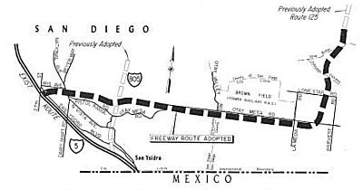 In 1965, the CHC adopted a freeway routing for Route 125
and Route 75. Route 75 later became Route 117 and then Route 905.
Specifically, the CTC adopted freeway routings for 9.7 miles of
interconnected Route 75 and Route 125 near the Mexican border. The new
alignment will take Route 75 easterly for 7.1 miles from I-5 near 27th
Street, just south of Iris Avenue in San Diego, to about a halfmile east
of Brown Field. From this point, the newly adopted alignment for Route 125
runs 2.6 miles northward, with a slight jog to the west between Johnson
Canyon and the Otay River. It connects on the north with a previously
adopted location for Route 125 northward to Route 54 near Sweetwater
Reservoir. The Route 75 and 125 freeways will form the southern and
eastern legs of a belt-line system of freeways around the San Diego
Metropolitan area.
In 1965, the CHC adopted a freeway routing for Route 125
and Route 75. Route 75 later became Route 117 and then Route 905.
Specifically, the CTC adopted freeway routings for 9.7 miles of
interconnected Route 75 and Route 125 near the Mexican border. The new
alignment will take Route 75 easterly for 7.1 miles from I-5 near 27th
Street, just south of Iris Avenue in San Diego, to about a halfmile east
of Brown Field. From this point, the newly adopted alignment for Route 125
runs 2.6 miles northward, with a slight jog to the west between Johnson
Canyon and the Otay River. It connects on the north with a previously
adopted location for Route 125 northward to Route 54 near Sweetwater
Reservoir. The Route 75 and 125 freeways will form the southern and
eastern legs of a belt-line system of freeways around the San Diego
Metropolitan area.
In 1967, Chapter 1483 split segment (b) and added the bridge, giving "(b) Route 5 to Fourth Street in Coronado via Silver Strand. (c) Orange Avenue in Coronado to Route 5 in San Diego via the San Diego-Coronado Toll Bridge. Subdivision (c) of this section shall not become operative until the San Diego-Coronado Toll Bridge and approaches are completed and open for traffic." It also added segment (d) as a temporary measure until the bridge was completed: "(d) Fourth Street to the San Diego-Coronado Ferry via Orange Avenue in Coronado. The portion of this route described in subdivision (d) shall cease to be a state highway when the portion of this route described in subdivision (c) is completed and open for traffic."
In 1968, Chapter 1139 combined segments (b) and (c) and removed (d): "(b) Route 5 to Route 5 via the Silver Strand and the San Diego-Coronado Toll Bridge.'
In 1976, Chapter 1354 deleted segment (a) and transferred it to Route 117, renumbered in 1985 to Route 905 (non-chargable interstate). This part of the route was LRN 281.
In 2016, Chapter 398 (AB 1500) added the following sections:
The segment of the route within the City Limit of San Diego between southern connection to I-5 and Imperial Beach was relinquished in August 2020 by the CTC.
 Pre 1964 Signage History
This route was not part of the original state signage of routes in 1934, although it was signed as Route 75 by 1938 (which is when it first shows up on the state highway map as signed Route 75). The route was LRN 199, and was defined in 1933. It ran along Orange, Silver Strand Blvd, and Palm Avenue, terminating at Orange and 4th Street.
 Status
Southern Silver Strand, Imperial Beach, and the Southern Connection to I-5
San Diego Relinquishment (11-SD-75 8.9/10.0)
 In June 2019, the CTC approved the following SHOPP amendment: 11-SD-75 8.9/10.0 PPNO
1264 ProjID 1117000113. Route 75 In the city of San Diego, from 0.2 mile
south of Route 5 (PM 8.930) to Georgia Street (San Diego city limit, PM
9.956). Financial Contribution Only (FCO) to City of San Diego to
relinquish roadway. Total $5,100K.
In June 2019, the CTC approved the following SHOPP amendment: 11-SD-75 8.9/10.0 PPNO
1264 ProjID 1117000113. Route 75 In the city of San Diego, from 0.2 mile
south of Route 5 (PM 8.930) to Georgia Street (San Diego city limit, PM
9.956). Financial Contribution Only (FCO) to City of San Diego to
relinquish roadway. Total $5,100K.
(Source: June 2019 CTC Minutes, Agenda Item
2.1a.(1) Item 27)
In June 2019, the CTC authorized the following SHOPP
support allocation: $100,000 11-SD-75 8.9/10.0 PPNO 1264 ProjID
1117000113. Route 75 In the city of San Diego, from 0.2 mile south of
Route 5 (PM 8.930) to Georgia Street (San Diego city limit, PM 9.956).
Relinquish roadway to the city of San Diego. PA&ED $100,000.
(Concurrent amendment under SHOPP Amendment 18H-010.
(Source June 2019 CTC Minutes, Agenda Item
2.5b.(2a) Item 41)
In June 2020, the CTC authorized the following
allocation with respect to this relinquishment: $5,000,000. 11-SD-75
8.9/10.0. PPNO 11-1264. ProjID 1117000113. EA 43000. Route 75 in the city
of San Diego, from 0.1 mile south of Route 5 (PM 8.930) to Georgia Street
(San Diego city limit, PM 9.956). Outcome/Output: Financial
Contribution Only (FCO) to City of San Diego to relinquish roadway.
(Source: June 2020 CTC Agenda, Agenda Item 2.5b.(1)
#34)
In August 2020, the CTC authorized relinquishment of
right of way in the City of San Diego on Route 75 (11-SD-75-PM 9.1/9.9)
under the terms and conditions as stated in the relinquishment agreement,
effective June 24, 2020, determined to be in the best interest of the
State. Authorized by Chapter 398, Statutes of 2016, which amended Section
375 of the Streets and Highways Code. This is basically from the end of
the I-5 offramp to the San Diego city limit.
(Source: August 2020 CTC Agenda, Agenda Item 2.3c)
In August 2012, the CTC approved SHOPP funding of $2,641,000 on Route 75 San Diego Cty PM 9.0 in the city of San Diego, on Route 75 at the E Route 75-N I-5 Connector Overcrossing (Bridge #57-0708F); and on Route 805 at the Kearny Villa Road Overcrossing (Bridge #57-0678). Outcome/Outputs: Seismic retrofit and rehabilitate two bridge structures to maintain structural integrity.
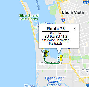
Imperial Beach Relinquishment (SD 9.9/11.2)
 In January - March 2016, it was reported that plans are underway to
decomission Route 75 (which would require some form of resolution, at
minimum, at the state level). The Corondo Times noted that Imperial Beach
is planning conversion of its portion of Route 75 to a city street. The
City of San Diego is in process of relinquishment for their section of
Route 75 on the San Diego Coronado Bay Bridge as well. However, Coronado
is not interested in taking back its section of the state highway, even
though Caltrans wants to relinquish the entirty of Route 75. The reason is
believed to be that bridge maintenance and other costs fears have
paralyzed Coronado elected city leaders. A 2009 planning report that discussed the the proposed Route 75/Route 282
Transportation Corridor Project encouraged the City of Imperial to
determine at an early stage if any portions of this project will require
relinquishment of Route 75, so that the City may begin consultations with
the City of San Diego, and the City of Coronado for acceptance of portions
of the route that may fall within their jurisdiction and require
relinquishment as well. The relinqishment is addressed in AB 2075 (2016),
which was initiated by Imperial Beach; Coronado has asked to be removed
from the bill.
In January - March 2016, it was reported that plans are underway to
decomission Route 75 (which would require some form of resolution, at
minimum, at the state level). The Corondo Times noted that Imperial Beach
is planning conversion of its portion of Route 75 to a city street. The
City of San Diego is in process of relinquishment for their section of
Route 75 on the San Diego Coronado Bay Bridge as well. However, Coronado
is not interested in taking back its section of the state highway, even
though Caltrans wants to relinquish the entirty of Route 75. The reason is
believed to be that bridge maintenance and other costs fears have
paralyzed Coronado elected city leaders. A 2009 planning report that discussed the the proposed Route 75/Route 282
Transportation Corridor Project encouraged the City of Imperial to
determine at an early stage if any portions of this project will require
relinquishment of Route 75, so that the City may begin consultations with
the City of San Diego, and the City of Coronado for acceptance of portions
of the route that may fall within their jurisdiction and require
relinquishment as well. The relinqishment is addressed in AB 2075 (2016),
which was initiated by Imperial Beach; Coronado has asked to be removed
from the bill.
(Source: Andy3175 @ AAroads; CoronadoTimes,
12/30/2015)
In September 2016, it was reported that a
transportation assembly bill (AB1500) that recently passed in the state
legislature could give Imperial Beach local control of its portion of
Route 75, a main thoroughfare into the small beach town. Also known as
Palm Avenue, it connects the Silver Strand and Coronado. According to
Imperial Beach, “It’s big for the city because we could move
forward and implement improvements in the Palm Avenue Master Plan and we
don’t have to get encroachment permits we can do it
ourselves.” Although the state legislature giving the bill a thumbs
up is a big deal it must get the seal of approval from the California
Transportation Commission, expected to happen sometime this fall. Once
approved by the Commission, Hall said city staff members would create a
cost benefit analysis—essentially a list of pros and cons to taking
on jurisdiction of the road to present to the City Council.
(Source: San Diego U-T, 9/15/2016)
In August 2018, the CTC authorized relinquishment of
right of way in the city of Imperial Beach on Route 75 from near Georgia
Street to Rainbow Drive (11-SD-75-PM 9.9/11.1), under terms and conditions
as stated in the relinquishment agreement dated July 12, 2018, determined
to be in the best interest of the State. Authorized by Chapter 398,
Statutes of 2016, which amended Section 375 of the Streets and Highways
Code.
(Source: August 2018 CTC Agenda Item 2.3c)
The following project was included in the final adopted 2018 SHOPP in March 2018: PPNO 1204. 11-San Diego-75 10.0/11.2. Route 75 In Imperial Beach, from Georgia Street to 0.2 mile north of Rainbow Drive. Relinquish roadway to Imperial Beach. Financial Contribution Only (FCO). Total Project Cost: $5,624K.
In June 2011, the CTC relinquished right of way in the city of Imperial Beach along Route 75 on and along Palm Avenue between 8th and 7th Streets (~ SD 10.641 to SD 10.79), consisting of collateral facilities.
In September 2011, the CTC approved $2,159,000 for rehabilitation of 13 lane miles of Route 75, from Rainbow Drive in Imperial Beach to Naval Amphibious Base Gate 4 (Tulagi Rd) in Coronado (~ SD 10.993 to SD 17.454).
In Coronado and Along the Silver Strand
In June 2015, it was reported that Caltrans was presenting the results of
its recently completed Engineering and Traffic Surveys of Route 75 and
Route 282 in Coronado. The survey recommended a five-mph increase in the
speed limit of Route 75 east of Orange Avenue (SD R19.729 to SD R20.533).
All other segments of the state highways in Coronado are recommended to
remain the same. Initially, the results of surveys indicated that a
five-mph increase on Third and Fourth Streets west of Orange Avenue, and a
10-mph increase on Third and Fourth Streets east of Orange Avenue would be
warranted. After consultation with City staff, Caltrans agreed that it was
appropriate to apply a five-mph reduction along Third and Fourth Streets
as allowed due to accident rates and residential density factors. The
result is no change in the current speed limit of 25 mph for the sections
of Third and Fourth Streets west of Orange Avenue (Route 282) and a
five-mph increase to 30 mph for the sections of Third and Fourth Streets
east of Orange Avenue (Route 75). Prior to 2005 the posted speed limit on
the majority of Third and Fourth Streets was 30 mph and 35 mph on Fourth
Street between Orange Avenue and the bridge. These speed limits were
reduced to 25 mph for the entirety of Third and Fourth Streets after a
speed survey performed by Caltrans in 2005.
(Source: eCoronado.com, 5/30/15)
Coronado Relinquishment (11-SD-75 PM 11.2/R20.1)
In February 2019, there was an update on the
relinquishment question. The broad brush details include Caltrans, the
State of California’s Transportation Agency would pay the city
$16.95 million to repair Route 282 or Third and Fourth Streets west of
Orange Avenue; Route 75 from the Toll Plaza to Tulagi Road; and Route 75
from Tulagi Road to the southern City Limit with Imperial Beach, to
adequate levels. The city of Coronado would then take over all operations
of highways. The deal would be in perpetuity, the highways could not be
returned to State control and turning the highways over to Coronado would
require legislative action at the state level. There’s a lot more to
Relinquishment than that. There is past history which could charitably be
described as ‘fractious,’ and there is a very real fear of the
unknown. The financial risk cannot be quantified at this time, and
information gathering is just now underway. Early discussions on
relinquishment have found Councilmembers Bill Sandke and Mike Donovan on
opposite ends of the thought spectrum on the issue, at least during
council discussions on the topic.
(Source: Coronado Eagle and Journal, 2/22/2019)
In September 2019, it was reported that the topic of
relinquishment was discussed at the September 2019 Coronado Council
meeting. This relates to negotiations for Coronado to acquire control and
operation of Route 75 and Route 282. Approved was an item that would
authorize City Manager Blair King to engage in negotiations with Caltrans
for the 9.79 miles of roadway in question: specifically, Route 75 from
Tulagi Road to the Southern City limits; Route 75 from Glorietta Boulevard
to Tulagi Road; and the full portion of Route 282 including Third, Fourth,
and Alameda between Third and Fourth Streets. The staff recommendation was
to pursue the relinquishment of all three segments of roadway. State
Senator Toni Atkins (D-39th District) has agreed to facilitate the
transaction, which ultimately requires legislative action, with the bill
signed by Governor Gavin Newsom. The big turnaround for this council from
the stance taken by their predecessors, was the fact that the now-public
Caltrans operational numbers reflect the transaction to be cost positive
for the City of Coronado. During a presentation to the Council by City
Director of Public Services and Engineering Cliff Maurer, it was revealed
that Caltrans receives an annual financial allotment through the State
Transportation Improvement Program (STIP) of $900,000, of which a total of
between $250,000 and $280,000 is actually spent in Coronado, with the
balance of the funding directed to other areas within Caltrans. Upping the
maintenance level to Coronado standards, essentially doubling the existing
Caltrans expenditures, would still leave a projected balance Coronado
could place into a sinking fund for future road maintenance. The other
major financial component that may make this transaction financially
feasible, is a potentially large lump-sum payment from Caltrans to the
City of Coronado to bring the 9.79 miles of roadway to an acceptable
condition. The first dollar figure run up the proverbial flagpole by
Caltrans was for $16.95 million with a projected payout in 2020-21.
Coronado’s consultants from Rick Engineering Company put the number
for a 2022 payout at $24 million. Another issue Coronado would include in
the transaction is that Caltrans would commit to providing catastrophic
damage response capabilities, within the limitations of their available
resources. The downside for Coronado is the city would now own 9.79 miles
of roadway and a bridge near the Cays, with all of the related operations
and maintenance expenses, forever. There are also insurance ramifications,
as Coronado is part of a Joint Powers Agreement called the CSAC Excess
Insurance Authority, which is a risk-sharing pool that proactively helps
control losses and prepare for different exposures. Through that entity,
the city is self-insured for a $250,000 deductible per incident, with
coverage up to $50 million. The key factor is the amount of the lump sum
payment. Coronado believes that thenumber (from Caltrans) is low. There is
a fair amount of time between the completion of an agreement and when
Coronado gets the road. In that time, the value of money is changing, and
the city needs to negotiate an appropriate amount of money to get the road
into good shape.
(Source: Coronado Eagle and Journal, 9/12/2019)
In June 2020, it was reported that during the City
Council meeting of June 16, 2020, the Coronado City Council approved by a
5-0 vote, acceptance of the $22 million financial package from Caltrans to
take over the operation of Route 75 and Route 282 in the city. Along with
an internal transfer of $9.3 million from the Fiscal Year 2020-21 budget,
the resulting $31.3 million fund, with interest, is projected to cover the
annual maintenance for the two state routes that run through Coronado. The
opening bid from Caltrans to bring the two state routes into good repair
was $16.95 million. Specifically, the descriptions of the state routes
that will be taken over by the City of Coronado include:
(Source: Coronado Eagle and Journal, 6/25/2020)
The San Diego-Coronado Bay Bridge is not included in
Relinquishment and will continue to be owned and operated by Caltrans.
Relinquishment of Route 75 and Route 282, once completed, means the
highways are owned by the City of Coronado in perpetuity. The City also
assumes all liability for the highways.
(Source: Coronado Eagle and Journal, 6/25/2020)
In August 2020, the CTC approved the following addition
to the SHOPP, which addressed the financial contribution for the
relinquishment: 11-SD-75 PM 11.2/R20.1 PPNO 1304 ProjID 1118000008 EA
43021. Route 75 In Coronado, from 0.2 mile north of Rainbow Drive to
Glorietta Boulevard; also the entirety of Route 282 (PM 0.0R/0.691R).
Financial Contribution Only (FCO) to City of Coronado to relinquish
roadway. PA&ED $160K Const Sup $22,000K TOTAL $22,160K. PA&ED
12/15/2020 Begin Const 9/6/2021.
(Source: August 2020 CTC Agenda, Agenda Item
2.1a.(2a) #12)
Related to the above, in August 2020 the CTC approved
the following financial allocation: $160,000 for PA&ED 11-SD-75
11.2/R20.1 PPNO 1304 ProjID 1118000008 EA43021 Route 75 In Coronado, from
0.2 mile north of Rainbow Drive to Glorietta Boulevard; also the entirety
of Route 282 (PM 0.0R/0.691R). Financial Contribution Only (FCO) to City
of Coronado to relinquish roadway.
(Source: August 2020 CTC Agenda, Agenda Item
2.5b.(2a) #36)
In February 2021, it was reported that there was a
hiccup in the relinquishment. SB 479 was introduced in the 2020
legislative session as the vehicle for Relinquishment to pass through the
legislature. The bill passed through committees in the State Assembly and
Senate and was sent up for a vote. Then a filibuster happened. This delay
resulted in a whole group of bills not making it through before the recess
of the legislative session at the end of the year. It was expected that
when the new legislature began in 2021, the bill would quickly proceed.
Unexpectedly, during that gap in time, the Navy raised new concerns and
demanded that additional language be included in the legislation. The city
was informed only after the fact when additional language had been
introduced. The specifics of the language requested was not released, but
the jist is that the Navy has demanded that any action taken (from road
improvements to special events) receive concurrence (approval) from Naval
Base Coronado. The city finds this untenable; in an effort to salvage the
agreement already made with state entities, the city proposed the Navy and
City agree on a side agreement that would attach to the bill. Specific
language was already included the bill to “provide continuous and
uninhibited defense access, continuity, and emergency capabilities for the
movement of military personnel, material, and equipment in both peacetime
and wartime... that the city shall not limit the type, weight, or
dimensions of vehicles needed for defense purposes that may use the
relinquished portion of Route 75 or Route 282.” The city continues
to work on an agreement.
(Source: Coronado Eagle and Journal, 2/15/2021)
In December 2022, the CTC amended the SHOPP related to
this project as follows: 11-SD-75 PM 11.2/R20.1 PPNO 1304 ProjID
1118000008 EA 43021. Route 75 In Coronado, from 0.2 mile north of
Rainbow Drive to Glorietta Boulevard; also the entirety of Route 282 (PM
0.0R/0.691R). Financial Contribution Only (FCO) to City of Coronado to
relinquish roadway. PA&ED $160K Const Sup $22,000K TOTAL $22,160K.
PA&ED 12/15/2020 Begin Const 9/6/2021. Note: Delete project.
The City of Coronado and US Navy did not reach an agreement on the
transfer and the relinquishment was not included in legislation.
(Source: December 2022 CTC Agenda, Agenda Item
2.1a.(1d) #30)
Constructed as freeway from Route 282 in Coronado to the Northern Connection with Route 5 in San Diego (~ SD 19.56 to SD R22.172).
Coronado Tunnel:
There have been reports that there is a study regarding constructing a double tunnel that would run for a mile beneath Coronado, connecting the western side of the Coronado Bridge to the North Island Naval Air Station (~ 282 SD 0.689R to 75 SD R19.729 to 75 SD R20.533). Currently, surface streets between the bridge and the Navy base carry as many as 96,000 vehicles a day - far above the capacity they were designed for and more traffic than any other arterial road in San Diego County.
The SAFETEA-LU act, enacted in August 2005 as the reauthorization of TEA-21, provided the following expenditures on or near this route:
Northern I-5 Terminus to Coronado Tidelands Park, including the Coronado Bridge
The San Diego-Coronado Bridge (Bridge 57-0857, SD R020.49) was originally a toll bridge, but the toll was removed on June 27, 2002. SANDAG is currently considering reinstating the tolls. The tolls would raise money for a proposed tunnel and other projects aimed at easing traffic congestion. San Diego released an analysis in April 2009 that found that tolls could raise an initial $140 million with a rate of $1.50 each way during the four- year construction of the tunnel from 2014 to 2018. The most expensive of two proposed tunnel designs is projected to cost $590 million. If new, higher rates are in place by 2019, tolls could generate up to an additional $460 million over a 40-year period, the study says. That figure is based on rates that could range from $1.50 per crossing during off-peak traffic hours to $5 per trip in peak traffic. That means drivers would pay $10 round trip to cross the bridge during peak traffic hours.
Coronado Bridge Suicide Barrier: (~ SD R20.49 to SD R21.664)
 In April 2015, it was reported that San Diego officials are moving forward with a study to
determine whether suicide barriers or nets could be installed to catch
jumpers on their way down. Since the San Diego-Coronado Bridge opened in
1969, the two-mile span has been the site of more than 360 suicides, with
the numbers surging since 2011. The study would determine whether the
state Department of Transportation could install nets similar to those
that San Francisco plans to add to the Golden Gate Bridge to prevent
suicides. The Coronado City Council recently made a similar endorsement,
and the nonprofit Coronado Bridge Collaborative has launched an online
campaign to raise the roughly $25,000 it estimates the study would cost.
In April 2015, it was reported that San Diego officials are moving forward with a study to
determine whether suicide barriers or nets could be installed to catch
jumpers on their way down. Since the San Diego-Coronado Bridge opened in
1969, the two-mile span has been the site of more than 360 suicides, with
the numbers surging since 2011. The study would determine whether the
state Department of Transportation could install nets similar to those
that San Francisco plans to add to the Golden Gate Bridge to prevent
suicides. The Coronado City Council recently made a similar endorsement,
and the nonprofit Coronado Bridge Collaborative has launched an online
campaign to raise the roughly $25,000 it estimates the study would cost.
(Source: LA Times, 4/27/2016; Image source: Caltrans District 11 Public Scoping Meeting Information)
In late May 2017, it was reported that Caltrans was
initiating a study of ways to deter suicides off the Coronado bridge. Long
sought by members of the island community, the study will evaluate the
feasibility, cost, impacts and risks of fencing or other barriers. Steven
Shultz, a Caltrans spokesman, said the study will take about 10 months to
complete. Its cost has not yet been determined, pending final decisions on
the scope of the work. More than 400 people have jumped to their deaths
since the San Diego-Coronado Bridge opened in 1969, according to Wayne
Strickland, a retired Coronado firefighter who is president of the Bridge
Collaborative for Suicide Prevention. Hundreds more people over the years
have gone to the bridge to die and changed their minds or were grabbed
before they could go over the 3-foot-tall side. Many approaches have been
done on different bridges, but in Coronado, the suicide-prevention
collaborative has been eyeing as a possible solution the kind of
inward-tilting, unclimbable fencing similar to the installation on the
Cold Spring Canyon Bridge on Route 154 in Santa Barbara County. Built in
1963, the 1,200-foot-long steel-arch bridge spans a gorge on Route 154 and
had been the site of more than 50 suicides before Caltrans installed a
10-foot high, $3 million fence in 2012. Engineering students at San Diego
State University designed a Cold Spring-like barrier for the 2-mile-long
Coronado bridge — high enough to deter jumpers, strong enough to
keep cars from crashing through — and estimated it would cost about
$11 million.
(Source: San Diego U-T, 5/20/2017)
In June 2018, it was noted that the study had been published. It describes the bridge as follows:
The Coronado Bridge is an iconic structure in the San Diego region. Its construction was completed in 1969 and it is part of Route 75 which connects the City of Coronado and the City of San Diego over the San Diego Bay. The bridge structure is of steel plate girder construction with a reinforced concrete deck. The route carries a large number of civilian and military commuters to Naval Air Station North Island and the Naval Amphibious Base in the City of Coronado.
The bridge main crossing of the San Diego Bay is approximately 7,400 feet in length spanning from Abutment 1 to Pier 30. The western approach (Coronado) which is approximately 1,900 feet long begins at the toll plaza in the City of Coronado and connects to the main crossing at Abutment 1. The eastern approach (San Diego) extends from the main crossing at Pier 30 and connects directly to I-5. Pier 30 also represents a transition from the main bridge to the east approach, and is the point at which the bridge superstructure transitions from steel to concrete. This portion of the bridge is approximately 2,000 feet long. The total length of the bridge, including both ends of approaches and the main crossing, is approximately 11,200 feet long.
The bridge horizontal alignment consists of a 2,800 foot long curve with an 1,800 foot radius between piers 4 and 17 connecting two perpendicular tangents. The vertical alignment of the bridge maintains a 4.67% max grade from both ends of approaches connected by a 2,100 foot vertical crest curve at the channel spans between Piers 18 and 21. The channel spans have a vertical clearance of approximately 200 feet.
The 2015 5-day annual average daily traffic (AADT) on the Coronado Bridge is approximately 83,000. The posted speed limit for this facility is 50mph. The bridge currently has a five lane configuration: two eastbound, two westbound, and a reversible middle lane with a moveable median barrier system installed in 1993 to facilitate weekday directional traffic demands. There are no existing shoulder widths on this bridge in order to accommodate the median barrier and reversible middle lane. The existing bridge railing is 34-inches high and is designed to redirect vehicles back onto the roadway if hit. There are no public pedestrian facilities and no bicycle access on the bridge except for special events.
The study notes numerous limitations that would impact a suicide barrier due to the need to perform maintenance operations on the bridge, such as inspections and painting. The study explored a number of options, including wire mesh fencing [an 8-9 foot modified Type 7 fence, with a tighter 1-inch mesh fencing material to restrict climbing and providing an 8-inch continuous gap at the bottom of the fence to facilitate Maintenance access to anchor bolts, air and water hook ups, and ropes used during their operations], wire mesh curved fencing (ala the Cold Springs Tavern Bridge, Route 154) [this adds an inward curve at the top towards the roadway to deter pedestrians from climbing over the barrier], Transparent Panel Barriers (as used in Aukland NZ) [8-9 feet minimum in height with perforations to reduce transverse and wind loading, using panels would be made of either glass (silicon based) or plexi-glass (petroleum based) materials, possibly curved at the top, with a possible 8-inch continuous gap at the bottom of the fence to facilitate Maintenance access to anchor bolts, air and water hook ups, and ropes used during their operations], a net system (as proposed for the Golden Gate Bridge, US 101) [a horizontal net system to the superstructure section at a location approximately 20-feet below the bridge deck and extend out from the bridge rail approximately 15-feet.], a "Thistle Barrier" [an alternative fence system that consists of deterrent spikes installed on top of the existing bridge rails], or just advisory signage.
In October 2019, the Governor signed SB 656 (Chapter 651, 10/8/2019), which required the Director of Transportation to select members for an advisory committee to provide input into the selection of a suicide deterrent system for the San Diego-Coronado Bridge that would include a representative from the Department of the California Highway Patrol, a mental health advocate, a member of a local suicide prevention group, residents of specified cities, and representatives of specified city and county governments. The bill would also provide for the selection to the advisory committee of one representative each by the Assembly Members or State Senators whose districts include the San Diego-Coronado Bridge.
In June 2020, a public scoping meeting was held
regarding the suicide barrier. The notice indicates that although official
figures have not been maintained since its opening in 1969, it is widely
believed that there have been approximately 400 deaths by suicide that
have occurred from the San Diego - Coronado Bridge on Route 75. After the
Golden Gate Bridge, it is recognized as the second most frequently used
bridge for suicide in the states. The Bridge does not have a permanent
physical suicide deterrent system. The standard operating procedure for
suicide attempts is closure of the Bridge. The Bridge has the highest
concentration of fatalities for a spot location on the state highway
system in Caltrans District 11 (San Diego and Imperial Counties) due to
deaths by suicide. Fatalities caused by suicide do not qualify under
current Highway Safety Improvement criteria and are not eligible for HSIP
funding. The existing TMS elements on the Bridge consist of six cameras
controlled exclusively by California Highway Patrol (CHP) staff stationed
at the Bridge Toll Plaza in Coronado. When CHP staff is not available at
the Toll Plaza, the cameras cannot be repositioned and are no longer
effective for monitoring activity on the bridge. In addition, existing
camera locations do not provide full coverage of the bridge and
surrounding areas. Non-physical suicide deterrence measures have been
implemented on the Bridge along with four-inch spikes installed on top of
the bridge rail in early 2019 as an interim measure. However, multiple
suicides and suicide attempts have still occurred from the Bridge. Many of
these have resulted in a complete closure of the Bridge, sometimes for
hours, requiring those traveling to or from Coronado Island, Naval Air
Station North Island, and the Naval Amphibious Base, to reroute by way of
the Silver Strand, a 23-mile detour adding 30 to 60 minutes of travel time
per vehicle per incident. Route 75 is part of the Strategic Highway
Network which provides defense access, continuity, and emergency
capabilities for movement of personnel and equipment in both peace and war
times. The plan is to install a permanent suicide deterrent on the San
Diego – Coronado Bay Bridge (Bridge) in San Diego County. The
Project also proposes to install minor improvements to the transportation
management system (TMS) elements at the Glorietta Toll Plaza, the Bridge,
and the I-5/Route 75 Interchange.
(Source: Caltrans District 11 Public Scoping Meeting Announcement, June 2020)
In January 2022, Caltrans released the draft San Diego
– Coronado Bay Bridge Suicide Deterrent Project (11-SD-75 PM
R20.1/R22.3 & 11-SD-5 PM R13.8/R14.3) environmental document for
review. Comments were due at the beginning of March 2022. The report noted
that during the initial planning phase of the proposed project, a range of
potential alternatives were identified for evaluation, including the three
physical concepts: a horizontal barrier, a vertical barrier on the
existing bridge railings, and a vertical barrier on new bridge railings.
Multiple design variations for the vertical barrier alternatives were also
included, such as a wire mesh fence, pivoting wire mesh fence, sliding
vertical cable fence, reverse folding wave fence, vertical net, and
horizontal cable fence. With project refinements, the vertical net design
variation of the vertical barrier alternative constructed on the existing
bridge railing has been identified as the proposed project. This would
affix a vertical net to the outside of the existing bridge railing. A
Caltrans Headquarters Division of Engineering Services’ Division of
Structures Design analysis resulted in a high confidence level that a new
railing would not be required to support the net. The vertical net would
be composed of an 8- to 10-foot-tall stainless-steel net affixed to top
and bottom perimeter tension cables. The tension cables would be strung
through and attached to fixed vertical posts approximately 20 or more feet
apart. The vertical net would be offset 4 to 8 inches behind the existing
bridge rail. The proposed project would include the following project
features and parameters:
(Source: "San Diego–Coronado Bay Bridge Suicide Deterrent Project ... Initial Study with Proposed Mitigated Negative Declaration", January 2022)
The proposed project would also include minor
improvements to the TMS elements at the Glorietta Toll Plaza, the Bridge,
and the I-5/SR-75 Interchange. These improvements would include upgrades
to the CCTV system using the existing conduit system, along with new CCTV
cameras at five locations along the bridge spans and one on the eastern
end of the Glorietta Toll Plaza. New vehicle detection systems (VDSs)
would be installed at the I-5/Route 75 Interchange and the Glorietta Toll
Plaza. A Changeable Message Sign would also be replaced at the Glorietta
Toll Plaza. No other work is anticipated at the Glorietta Toll Plaza
except the possibility of staging materials. Signage may be replaced or
new signage installed as needed.
(Source: "San Diego–Coronado Bay Bridge Suicide Deterrent Project ... Initial Study with Proposed Mitigated Negative Declaration", January 2022)
The proposed project design would require enclosed
substructure bays beneath the Bridge to allow for maintenance of the
Bridge, which would no longer be accessible from the bridge deck due to
the vertical net. Spans 1 through 3 and Spans 18 through 20 (Box Girders)
of the Bridge would not require enclosed bays. Spans 4 through 15 along
with Spans 23 through 27 would require enclosed outer bays. Spans 16, 17,
21, 22, 28, and 29 would require enclosed center and outer bays. The
enclosure method would be a grating “floor” and supports that
would connect to the existing substructure. These bays would be enclosed
using fiber-reinforced or noncorrosive metal punched plank grating. The
fiber-reinforced grating would be a minimum of 70 percent open and a
maximum of 2 inches in height. The fiber-reinforced grating would be
a darker color than the existing grating on the structure.
(Source: "San Diego–Coronado Bay Bridge Suicide Deterrent Project ... Initial Study with Proposed Mitigated Negative Declaration", January 2022)
Currently, a driver going in the westbound direction
can see the tops of vehicles over the existing outside bridge rail along
the curve of the Bridge. With the construction of a vertical net, this
existing line of sight would be affected. Speed reduction from the current
50 miles per hour (mph) is being considered for both directions along the
Bridge to account for this impact on line of sight. New speed limit signs
and pavement delineation may also be needed for this speed limit change.
(Source: "San Diego–Coronado Bay Bridge Suicide Deterrent Project ... Initial Study with Proposed Mitigated Negative Declaration", January 2022)
In December 2022, the CTC approved for future
consideration of funding the following project for which a MND has been
completed: Route 75 and I-5 in San Diego County (11-SD-75, PM R20.1/R22.3,
11-SD-5, PM R13.8/R14.3). Install a physical suicide deterrent on the San
Diego-Coronado Bay Bridge and install minor improvements at the I-5/Route 75 interchange, in San Diego County. (PPNO 11-1352). The project is
located on Route 75 in San Diego from postmile R20.1 to R22.3 and on I-5
from postmile R13.8 to R14.3, in San Diego County. The Department proposes
to construct a vertical net as a suicide deterrence system along both
sides of the Bridge, as well as minor improvements to the TMS elements at
the Glorietta Toll Plaza. The estimated total overall cost of the project
is $127,000,000. The project is not currently programmed in the
SHOPP. The project is estimated to begin in 2026-27. A copy of the
MND has been provided to Commission staff. The project will result in less
than significant impacts to the environment after mitigation. The
following resource areas may be impacted by the project: peregrine falcon.
Avoidance and minimization measures will reduce any potential effects on
the environment. These measures include, but are not limited to, avoid
nesting season, pre-construction surveys, and implement exclusion zones.
As a result, an MND was completed for this project.
(Source: December 2022 CTC Agenda, Agenda Item
2.2c.(1))
In January 2023, the CTC added the following SB1
project into the 2022 SHOPP: 11-SD-75 R20.1/R22.261. PPNO 11-1352; ProjID
1119000044; EA 43063. Route 75 In the city of San Diego, on San
Diego-Coronado Bay Bridge № 57-0857 and EB Route 75 to NB I-5
Connector Overcrossing № 57-0912G; also on Route 5 at SB I-5 to SB
Route 75 Connector Overcrossing № 57-0939H (PM R13.8/R14.3).
Install suicide deterrent fences along bridges. Allocation ($ ×
1,000): PA&ED $17,140; PS&E $20,900; R/W Sup $17; ⊘Con
Sup $15,000; R/W Cap $331; ⊘Const
Cap $94,800; TOTAL $124,200. FY25-26. Concurrent COS allocation under
Resolution FP-22-45; January 2023. SB1 Baseline Agreement Required. Begin
Const: 9/30/2026.
(Source: January 2023 CTC Agenda, Agenda Item 2.1a.(1b) #2)
In January 2023, the CTC approved SB1 pre-construction
project phase allocation of $14,000,000. 11-SD-75 R20.1/R22.261.
PPNO 11-1352; ProjID 1119000044; EA 43063. Route 75 In the city of San
Diego on San Diego-Coronado Bay Bridge № 57-0857 and EB Route 75 to
NB I-5 Connector Overcrossing № 57-0912G; also on Route 5 at SB I-5
to SB Route 75 Connector Overcrossing № 57-0939H (PM
R13.8/R14.3). Install suicide deterrent fences along bridges. Future
consideration of funding approved under Resolution E-22-101; December
2022. Concurrent Amendment under SHOPP Amendment 22H-006; January
2023. PS&E $14,000,000.
(Source: January 2023 CTC Agenda, Agenda Item 2.5b.(2b) #10)
In June 2023, the CTC approved the following SHOPP SB1
Pre-Construction Phase (environmental support, design, and R/W support)
allocation: $69,000. 11-SD-75 R20.1/R22.261. PPNO 11-1352; ProjID
1119000044; EA 43063. Route 75 In the city of San Diego, on San
Diego-Coronado Bay Bridge № 57-0857 and E75-N5 Connector
Overcrossing № 57-0912G; also on Route 5 at S5-S75 Connector
Overcrossing № 57-0939H (PM R13.8/R14.3). Install suicide
deterrent fences along bridges. PS&E, R/W Sup, R/W Cap Only. Future
consideration of funding approved under Resolution E-22-101; December
2022. As part of this allocation request, the Department is requesting to
extend the completion of the R/W Support phase an additional 5 months
beyond the 72 month deadline. Allocation: R/W Sup $69,000.
(Source: June 2023 CTC Agenda, Agenda Item 2.5b.(2b) #10)
Coronado Bridge Pedestrian and Bicycle Lanes: (~ SD R20.49 to SD R21.664)
In March 2017, it was reported that a report headed for a San Diego Assn. of Governments committee says the concept of pedestrian and bicycle lanes across the bridge — dreamed of even before the bridge opened in 1969 — contains no “fatal flaws” except perhaps this one: It could cost as much as $210 million and might require bringing back toll charges that ended 15 years ago. Funded by a $75,000 county grant, the study was conducted by architectural firm HNTB and outlined three ways to cross the bridge on bike or feet:
Navy and Caltrans officials raised various issues in
comment letters, such as blocked passage of Navy ships between two of the
central piers in addition to security and safety concerns. Caltrans said
13 agencies would have some say in permits and permission. The tube
concept was advanced by retired architect Lew Dominy and the good news,
according to the study, is that the bridge can be structurally modified.
But as Caltrans said in its comment letter, the bridge will become
historic in 2019 and a visual impact analysis is needed to determine
whether the original sleek, award-winning look would be diminished.
Another concern was whether the 195-foot clearance could be retained for
Navy ships and cargo traffic. One of the passages would not be clear
because the tube would have to be lowered 30 feet to meet accessibility
standards for the disabled. The tube could be routed around the affected
piers to avoid that problem. But cost appears to be the biggest
impediment.
(Source: San Diego U-T, 3/29/2017)
 Named Structures
 Bridge 57-0857 (SD R020.49), over the Coronado Bay in San Diego, is named the "San
Diego-Coronado Bay Bridge". It was built in 1969, and named by
Assembly Concurrent Resolution 85, Chapter 150, in 1989.
Bridge 57-0857 (SD R020.49), over the Coronado Bay in San Diego, is named the "San
Diego-Coronado Bay Bridge". It was built in 1969, and named by
Assembly Concurrent Resolution 85, Chapter 150, in 1989.
(Image source: AAroads)
 Other WWW Links
 Scenic Route
[SHC 263.1] Entire route.
 Statistics
Overall statistics for Route 75:
 Commuter Lanes
An HOV exclusive lane exists on the Toll Plaza at the Coronado Bridge. It requires two or more occupants, and is open 24 hours a day, 7 days a week.
 Pre-1964 Legislative Route
The route that became LRN 75 was first defined in 1931 by Chapter 82 as the route from Walnut Creek to Oakland. California Highways and Public Works, in April 1931, reported that Joint Highway District Number 13, composed of Alameda and Contra Costa counties, had organized for construction of a public highway and tunnel to supersede the pre-1931 narrow, crooked and inadequate 'Tunnel road in Alameda County and to improve the Contra Costa County road from the tunnel to the town of Walnut Creek. The state proposed for inclusion as a state highway that portion of the route in Contra Costa County between. the tunnel and Walnut Creek, a distance of 9.6 miles. Based on the volume and class of traffic on the pre-1931 tunnel road and on the other highways leading into Oakland (one from Livermore via Hayward, the other from Martinez through Crockett), and estimating the effect of better facilities in the Walnut Creek area, the conservative 12 hour traffic was anticipated for 1940 as equivalent to a 24 hour traffic of 17K vehicles on Sundays and 10K on weekdays. The state felt this route qualified for state inclusion based on volume, importance, and character of 1931 and future traffic.
LRN 75 was extended in 1933 with two segments: one from [LRN 75] near Walnut Creek to [LRN 5] near Stockton via Antioch, and one from [LRN 4] near Stockton to [LRN 65] near Altaville. In 1935, the route was defined in the highway code as:
In 1949, Chapter 1467 added a branch to Martinez as segment (b): “Route (a) above, north of Walnut Creek to Martinez”
In 1951, Chapter 1562 changed “[LRN 5] near Stockton” to “[LRN 4] near Stockton”.
In 1953, Chapter 1737 reworded segment (b) [2] to be “Route (a) above, north of Walnut Creek to a connection with [LRN 74] in Benecia”. This change was contingent on the acquisition by the Department of Public Works of the ferry system operated across the Carquinez Straights between the cities of Benecia and Martinez. This was done because the city of Martinez was about to close down the ferry system across the straights, and it was necessary to keep the ferry in operation to serve numerous refineries, chemical plants, steel companies, and other industries necessary for national defense, workers commuting both to and from such industries, and the extremely important Benecia Arsenal. The chapter also mistakenly deleted (c), from [LRN 4] near Stockton to [LRN 65].
In 1954, Chapter 8 from the Extraordinary Session corrected the deletion of (c)
In 1957, Chapter 1911 changed "[LRN 74] at Benecia" to "near Benecia".
In 1959, Chapter 1698 would have changed the definition further, deleting the Benecia branch (segment (b)), and changing (c) to be "[LRN 4] near Stockton to [LRN 249] near Farmington", but that was overtaken by the 1963 renumbering.
Signage on this route was as follows:
This was signed as Route 24, later Route 4 between US 50 (present-day I-580) in Oakland and Walnut Creek. A brief portion in Stockton appears to be a duplicate with LRN 5 (specifically, Route 4 between El Dorado St and Mariposa St.). From Stockton proper, it ran S along Mariposa St to LRN 4 (US 99).
LRN 75 was cosigned as Route 21/Route 24 between Walnut Creek and the vicinity of Pleasant Hill; this is present-day I-680.
LRN 75 was signed as Route 24 between the vicinity of Pleasant Hill and Concord. The stretch from I-680 N of Concord to Route 4 is signed Route 242, but was previously signed as Route 24.
LRN 75 was cosigned as Route 4/Route 24 between Concord and 4 mi E of Antioch. It was signed as Route 4 from 4 mi E of Antioch to Stockton.
This segment was signed as Route 21 between Walnut Creek and Benicia. It was later signed as part of I-680.
This was signed as Route 4. This left US 99 along Farmington Road.
© 1996-2020 Daniel P. Faigin.
Maintained by: Daniel P. Faigin
<webmaster@cahighways.org>.
 From Route
  Route 74
 Route 76