
 California Highways:
Click here for a key to the symbols used. An explanation of acronyms may be found at the bottom of the page.
 Routing
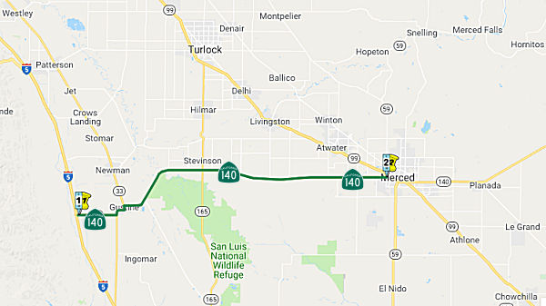 From Route 5 near Gustine to Route 99 near Merced.
 Post 1964 Signage History
As defined in 1963, this segment was "(a) Route 5 near Gustine to Route 99 near Merced." This definition has remained unchanged.
 Pre 1964 Signage History
This segment was not part of the original routing of Route 140, but was signed by 1963. It was LRN 122. The portion between Route 33 and Route 99 was defined in 1933. It was moved off of River Road in 1937. The remainder was defined in 1959.
 Status
Route 140/Route 165 Intersection Improvements (10-Merced-140 PM 16.0/16.5)
The 2020 SHOPP, approved in May 2020, included the
following New Mobility item of interest: 10-Merced-140 PM 16.0/16.5 PPNO
3438 Proj ID 1017000175 EA 1H020. Route 140 near Hilmar, at the
intersection of Route 140 (PM MER 16.0/16.5) and Route 165 (PM MER
26.6/27.1). Install a signal with dedicated left-turn lanes or construct
roundabout. Programmed in FY23-24, with construction scheduled to start at
the end of December 2024. Total project cost is $9,871K, with $5,200K
being capital (const and right of way) and $4,671K being support
(engineering, environmental, etc.).
(Source: 2020 Approved SHOPP a/o May 2020)
In August 2022, the CTC approved the following
pre-construction phase allocation: $2,407,000. 10-Mer-140 16/16.5. PPNO
10-3438; ProjID 1017000175; EA 1H020. Route 140 Near Hilmar, at the
intersection of Route 140 (PM 16.0/16.5) and Route 165 (PM 26.6/27.1).
Install a signal with dedicated left-turn lanes or construct
roundabout. Programmed (Actual) allocations: FY23-24 PS&E $1,581,000
($1,766,000); R/W Sup $641,000 ($641,000).
(Source: August 2022 CTC Agenda, Agenda Item 2.5b.(2a) #22)
In June 2023, the CTC amended the following project in
the 2022 SHOPP: 10-Mer-140 16.0/16.5. PPNO 10-3438; ProjID 1017000175; EA
1H020. Route 140 near Hilmar, at the intersection of Route 140 (PM MER
16.0/16.5) and Route 165 (PM MER 26.6/27.1). Install a signal with
dedicated left-turn lanes or Construct roundabout.
Note: Update description to remove the option to install a signal with
dedicated left-turn lane, which was not selected. Increase in Const Cap is
due to a refined estimate that increased quantities and updated unit
costs. Increase R/W Cap due to State’s responsibility of the
relocation of water district irrigation culverts and boxes. Move
delivery year to allow sufficient time to develop project design and to
complete appraisal & acquisition and utility relocation. Allocation ($
× 1,000): R/W Cap $255 $1,142; Const Cap $4,945
$8,088.
(Source: June 2023 CTC Agenda, Agenda Item 2.1a.(1d) #79)
 Naming
 The portion of Route 140 between PM MER 6.5 and MER 11 in the County of Merced is named the
“Paul Vincent Rotondaro Memorial Highway”. It was
named in memory of Paul Vincent Rotondaro, who grew up in the City of
Merced, and is an alumnus of Our Lady of Mercy School and Golden Valley
High School. During his time at Golden Valley High School, Paul was an
active member in the Future Farmers of America, as well as an outstanding
offensive lineman for the Golden Valley Cougars football team. After
graduation from high school, always seeking to expand his knowledge, Paul
graduated from Merced College, where he received his Associate of Science
degree in Fire Science and was actively working on his bachelor’s
degree. Paul began his career of public service with CAL-FIRE as a
Firefighter 1 at the Ahwahnee Fire Station in the Madera-Mariposa-Merced
Unit in 2006; and excelled at CAL-FIRE, promoting to Firefighter II in the
Merced Division of the Madera-Mariposa-Merced Unit in 2011 and to LT Fire
Apparatus Engineer in 2012, transferring to the Riverside Unit as a
permanent Fire Apparatus Engineer in 2015, and returning to
Madera-Mariposa-Merced Unit in 2016 to become a Fire Captain shortly
thereafter. Paul performed many aspects of the job, including as an active
participant on the Type 1 Hazardous Materials team in Merced, a member of
the CAL-FIRE Incident Management Team 3 in the Finance Section, a member
of the Merced County Type 2 Rescue team, overseeing radio technology
issues for the entire Merced County Fire Department, and serving as part
of the aircraft rescue and firefighting team at Castle Airport. Paul was
killed on October 2, 2019, in a head-on collision while on duty with
CAL-FIRE. Named by Assembly Resolution ACR 144, Res. Chapter 131, 08/19/22.
The portion of Route 140 between PM MER 6.5 and MER 11 in the County of Merced is named the
“Paul Vincent Rotondaro Memorial Highway”. It was
named in memory of Paul Vincent Rotondaro, who grew up in the City of
Merced, and is an alumnus of Our Lady of Mercy School and Golden Valley
High School. During his time at Golden Valley High School, Paul was an
active member in the Future Farmers of America, as well as an outstanding
offensive lineman for the Golden Valley Cougars football team. After
graduation from high school, always seeking to expand his knowledge, Paul
graduated from Merced College, where he received his Associate of Science
degree in Fire Science and was actively working on his bachelor’s
degree. Paul began his career of public service with CAL-FIRE as a
Firefighter 1 at the Ahwahnee Fire Station in the Madera-Mariposa-Merced
Unit in 2006; and excelled at CAL-FIRE, promoting to Firefighter II in the
Merced Division of the Madera-Mariposa-Merced Unit in 2011 and to LT Fire
Apparatus Engineer in 2012, transferring to the Riverside Unit as a
permanent Fire Apparatus Engineer in 2015, and returning to
Madera-Mariposa-Merced Unit in 2016 to become a Fire Captain shortly
thereafter. Paul performed many aspects of the job, including as an active
participant on the Type 1 Hazardous Materials team in Merced, a member of
the CAL-FIRE Incident Management Team 3 in the Finance Section, a member
of the Merced County Type 2 Rescue team, overseeing radio technology
issues for the entire Merced County Fire Department, and serving as part
of the aircraft rescue and firefighting team at Castle Airport. Paul was
killed on October 2, 2019, in a head-on collision while on duty with
CAL-FIRE. Named by Assembly Resolution ACR 144, Res. Chapter 131, 08/19/22.
(Image source: Cal Fire Foundation)
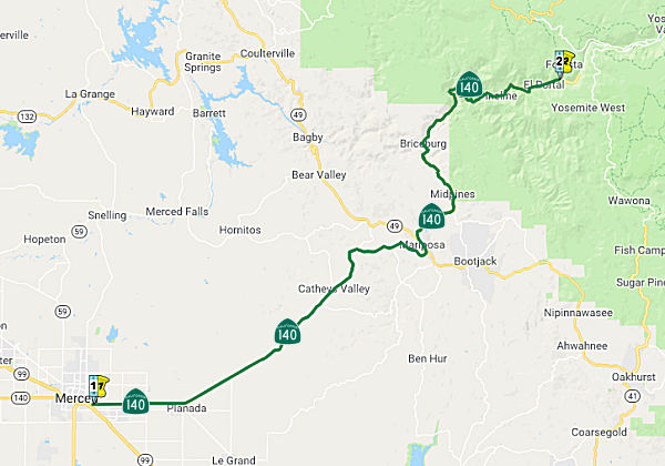 From Route 99 near Merced to Yosemite National Park near El Portal via
Mariposa.
From Route 99 near Merced to Yosemite National Park near El Portal via
Mariposa.
Post 1964 Signage HistoryAs defined in 1963, this segment ran from "(b) Merced to Yosemite National Park near El Portal via Mariposa."
In 1976, Chapter 1354 changed the origin to "(b) Route 99 near Merced to …"
Pre 1964 Signage HistoryIn 1934, Route 140 was signed along the route from Merced to Jct. Route 120 through Yosemite National Park via Mariposa. It was part of LRN 18. The segment from Merced to Mariposa was defined in 1909. From Mariposa to Yosemite National Park was defined in 1916. The portion from the old boundary of Yosemite National Park near Crane Flat to Route 120 was originally part of the route, defined in 1915, but was removed in 1943. There are points where this road has been rebuilt, and the old roadbed is still visible.
Currently, Route 120 enters Yosemite National Park in Tuolumne County via
the modern Big Oak Flat Road. Originally Route 120 entered Yosemite
National Park via the Old Tioga Pass Road and Route 140 entered via the
Old Big Oak Flat Road. The Big Oak Flat Road is the second oldest highway
into Yosemite just behind the Old Coulterville Road. Much of the alignment
of Route 120 follows the path set out by the Big Oak Flat Road. Details on
the history of the entrance into Yosemite and the changes in routing may
be found in the Gribblenation Blog "Old California State Route 140 and California State Route 120 entrances to Yosemite National Park".
(Source: Gribblenation Blog "Old California State Route 140 and California State Route 120 entrances to Yosemite National Park")
Tom Fearer (Max Rockatansky) on AAroads notes that the alignment of Tioga
Pass Road used to be very different in the early days of the state highway
system. Route 120 took a turn on what is now Evergreen Road to Aspen
Valley Road which used to be the original routing of Tioga Pass Road.
Route 140 from Evergreen Road used the modern alignment of Route 120 to
Yosemite National Park. The alignments can be seen very easily on the 1935 Tuolumne County Map. Tioga Pass Road originally traversed Aspen Valley way north of the modern road where it met up with the modern
alignment of the road via White Wolf Road. Sometime between 1942 and 1944,
Tioga Pass Road was moved to the modern realignment which resulted to
changes to Route 120 and Route 140. Route 140 was cut back to the El
Portal Entrance of Yosemite on the Merced River while Route 120 was
rerouted off of Evergreen Road onto Big Oak Flat Road where Route 120
enters Yosemite today. The changes are reflected on the 1954 and 1955
state highway maps.
(Source: Tom Fearer (Max Rockatansky) on AARoads, 7/8/2017)
Route 140 east of Merced was one of the very first state highways to be
commissioned (it was LRN 18) as an "all-weather" route into Yosemite. But
like all roads built next to rivers to take advantage of the relatively
low elevation, the trade-off is perennial flood damage.
(Source: Scott Parker (SParker) at AAroads, 7/26/2016)
 At some point, Route 140 (LRN 18) was rerouted in Mariposa. The previous routing appears to correspond
to 6th, Bullion Street, and 8th/Old Highway N.
At some point, Route 140 (LRN 18) was rerouted in Mariposa. The previous routing appears to correspond
to 6th, Bullion Street, and 8th/Old Highway N.
(Source: Joel Windmiller, via Mariposa and History Page, 10/2022)
StatusNote: For a discussion of the Merced-Atwater Expressway and Campus Parkway to UC Merced, see Route 59.
In January 2008, the CTC relinquished right of way in the city of Merced, at Glen Avenue (~ MER 35.886), consisting of a reconstructed and relocated city street.
Bradley Overhead (~ MER 36.483 to MER 37.396)
In October 2006, the CTC had on its agenda a resolution for approval for future consideration of funding a project on Route 140 in Merced County for which a Final Environmental Impact Report (FEIR) has been completed. The project is partially funded in the 2006 State Transportation Improvement Program (STIP) for Project Approval and Environmental Document (PA&ED) and Plans, Specifications and Estimate (PS&E) for $2,712,000 in the Regional Improvement Program (RIP). The total estimated project cost is $41,500,000 for capital and support. Construction is estimated to begin in Fiscal Year (FY) 2008-2009. The project is referred to as the "Bradley Overhead and Replacement Project", and is just E of Merced (~ MER 037.07).
In August 2012, the CTC approved an additional $1,763,000 in funding in the city of Merced, from Marthella Avenue to Santa Fe Avenue at the Bradley Overhead (~ MER 36.483 to MER 37.396). The goal is to widen from 2 to 4 lanes with 2-way left turn lane and sidewalks. The funding should add 2.2 lane miles.
In January 2017, the CTC relinquished right of way in the city of Merced along Route 140 on Baker Drive (10-Mer-140 PM 36.8/37.2, between Parsons and E Santa Fe), consisting of collateral facilities. The City, by relinquishment agreement dated March 20, 2008 agreed to waive the 90-day notice requirement and accept title upon relinquishment by the State. At the same time, the CTC also authorized relinquishment of right of way in the county of Merced along Route 140 on Baker Drive and Santa Fe Avenue (10-Mer-140 PM 37.1/37.4), consisting of collateral facilities. The County, by relinquishment agreement dated July 31, 2007 agreed to waive the 90-day notice requirement and accept title upon relinquishment by the State.
Planada Intersection Improvements (10-Mer-140 43.5/43.9)
 In March 2021, the CTC amended the following project into the 2020 SHOPP: (1a) #17.
10-Mer-140 43.5/43.9 PPNO 3506 ProjID 1020000188 EA 1M170. Route 140 Near
Planada, from west of Plainsburg Road to Sutter Street. Intersection
improvements. PA&ED $1,090K; PS&E $1,530K; R/W Sup $410K; Con Sup
$1,450K; R/W Cap $2,760K; Const Cap $4,520K TOTAL $11,760K. Begin const.
12/27/2024.
In March 2021, the CTC amended the following project into the 2020 SHOPP: (1a) #17.
10-Mer-140 43.5/43.9 PPNO 3506 ProjID 1020000188 EA 1M170. Route 140 Near
Planada, from west of Plainsburg Road to Sutter Street. Intersection
improvements. PA&ED $1,090K; PS&E $1,530K; R/W Sup $410K; Con Sup
$1,450K; R/W Cap $2,760K; Const Cap $4,520K TOTAL $11,760K. Begin const.
12/27/2024.
(Source: March 2021 CTC Agenda, Agenda Item
2.1a.(1a) #17)
In March 2021, the CTC approved the following
pre-construction support phase allocation(s): (2a) #19. $1,090,000
(PA&ED). 10-Mer-140 43.5/43.9. PPNO 10-3506; ProjID 1020000188; EA
1M170. Route 140 Near Planada, from west of Plainsburg Road to Sutter
Street. Intersection improvements. (Concurrent Amendment under SHOPP
Amendment 20H-006; March 2021.) Prog. year 23-24.
(Source: March 2021 CTC Agenda, Agenda Item
2.5b.(2a) #19)
In March 2023, the CTC approved for future
consideration of funding the following project for which a ND has been
completed: Route 140 in Merced County. Reduce the number and severity of
broadside and head-on collisions by improving intersection control on SR
140, in Merced County. (10-Mer-140, PM 43.5/43.9, PPNO 3506). The project
is located on Route 140 from postmile 43.5 to 43.9, in Merced County. The
Department proposes to reduce the number and severity of broadside and
head-on collisions at this location by constructing an intersection
control improvement. In addition, project work will include sidewalks and
American with Disabilities Act compliant curb ramps. The project is fully
funded and currently programmed in the 2022 SHOPP for a total of
$11,760,000 which includes Right of Way (support and capital) and
Construction (support and capital). Construction is estimated to begin
2024-25. The scope, as described for the preferred alternative, is
consistent with the project scope as programmed by the Commission in the
2022 SHOPP.
(Source: March 2023 CTC Agenda, Agenda Item 2.2c.(1))
In March 2023, the CTC approved the following
pre-construction project support phase SHOPP (2a) or SB1 (2b) allocation:
$2,002,000. 10-Mer-140 43.5/43.9. PPNO 10-3506; ProjID 1020000188; EA
1M170. Route 140 Near Planada, from west of Plainsburg Road to Sutter
Street. Intersection improvements. Concurrent consideration of funding
under Resolution E-23-30; March 2023. PS&E $1,530,00; R/W Sup $410,000
(Programmed) $472,000 (Allocated).
(Source: March 2023 CTC Agenda, Agenda Item 2.5b.(2a) #19)
In April 2021, it was reported that construction was starting on a
project that will improve pedestrian safety and traffic conditions from
the Route 140/ Route 49 south (~ MPA 21.238) junction to 12th Street (~
MPA 21.805) in Mariposa. Work is scheduled to be completed in winter 2021.
The project will include installation of pedestrian-activated in-roadway
warning lights, textured concrete crosswalks, sidewalk enhancements,
historical style overhead lighting at intersections, ADA-compliant ramps
with cast iron detectable warning pads, handrails, a raised textured
concrete boardwalk within Art Park, and many more unique features.
Caltrans’ design and engineering teams collaborated with Mariposa
County and area residents to ensure the materials blend with the
historical character of the Mariposa Town Historic District, which is on
the National Register. The $5.7 million project was awarded to Ibarra
General Engineering Inc. of Riverside, California.
(Source: Sierra Sun Times, 4/20/2021)
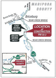 In March 2016, it was reported that Caltrans was holding
public meetings regarding a project to repair a failed slope beneath an
84-inch reinforced concrete pipe culvert adjacent to the eastbound lane of
Route 140 at PM MPA 32.2 in Mariposa County. Construction of a rockfilled
gabion basket wall with stone base support/buttress is the proposed repair
method to repair the failed slope and stop erosion from the culvert at
this site. The purpose of the project, also known as the SR-140 Slope
Repair Project, is to prevent further erosion of the slope and protect the
highway and the associated culvert. Caltrans is the lead agency for the
preparation of the environmental document for the project pursuant to both
the California Environmental Quality Act and the National Environmental
Policy Act. The location is S of Briceberg, between the two Bear Creek
Bridges.
In March 2016, it was reported that Caltrans was holding
public meetings regarding a project to repair a failed slope beneath an
84-inch reinforced concrete pipe culvert adjacent to the eastbound lane of
Route 140 at PM MPA 32.2 in Mariposa County. Construction of a rockfilled
gabion basket wall with stone base support/buttress is the proposed repair
method to repair the failed slope and stop erosion from the culvert at
this site. The purpose of the project, also known as the SR-140 Slope
Repair Project, is to prevent further erosion of the slope and protect the
highway and the associated culvert. Caltrans is the lead agency for the
preparation of the environmental document for the project pursuant to both
the California Environmental Quality Act and the National Environmental
Policy Act. The location is S of Briceberg, between the two Bear Creek
Bridges.
(Source: Sierra Sun Times, 3/23/2016)
Ferguson Slide Rock Shed / Major Damage Repair (10-MPA-140 42.0/42.7)
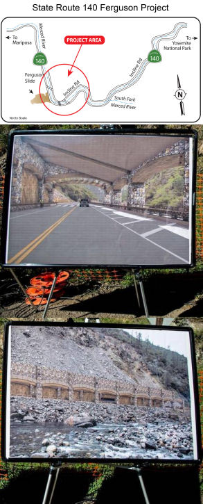 On April 29, 2006, there was a huge landslide
that covered about 300 feet of highway between Mariposa and Yosemite
National Park. It is unclear if the original alignment can be repaired. On
July 20, CalTrans started building a limited bypass around the slide area,
and this was finished on July 31, 2006. Yosemite tourists are urged to
enter the park via Route 120 from Oakdale or Route 41 from Fresno.
On April 29, 2006, there was a huge landslide
that covered about 300 feet of highway between Mariposa and Yosemite
National Park. It is unclear if the original alignment can be repaired. On
July 20, CalTrans started building a limited bypass around the slide area,
and this was finished on July 31, 2006. Yosemite tourists are urged to
enter the park via Route 120 from Oakdale or Route 41 from Fresno.
In May 2014, the CTC approved for future consideration of funding a project in Mariposa County that will construct repairs or a permanent bypass on a portion of Route 140 that was blocked and damaged by the Ferguson rockslide. The project is programmed in the 2014 State Highway Operation and Protection Program. The total estimated cost is $132,550,000 for capital and support. Construction is estimated to begin in Fiscal Year 2015-16.
In June 2015, an update was provided on the Ferguson
Project. The $133 million project will restore highway access to a section
of Route 140 that was damaged by the Ferguson rock slide in 2006. The two
phase project will result in a two-lane 750-foot rock shed along the
existing route. Caltrans started the project in March 2015, when crews
removed about 63,000 tons of rock and debris. Subsequent visual inspection
of the exposed slope led Caltrans to reconsider the lateral design
strategy for the rock shed. The approach transitioned to a wall structure
that would require Caltrans to leave the remaining rock to help facilitate
geotechnical bores and ultimately construct the rock shed. As of June
2015, the structure was designed to include two 12-foot-wide lanes, two
8-foot-wide outside shoulders and a 4-foot-wide emergency walkway on the
river side. Motorists are currently constrained by one-way traffic
control, using a temporary bypass route. Construction of the rock shed is
anticipated to begin in 2016. The two lanes on the original alignment will
be reopened once the project is complete. Other alternatives considers,
but ultimately not selected, included Alternative T-3, which would have constructed a tunnel on a new alignment, tunneling into the west canyon wall, under the rockslide, and realigning with the existing highway, and the no-build alternative.
(Source: Merced Sun-Star, May 25, 2015, CaltransInformation
Page)
In March 2016, it was reported that work will resume in
summer 2016 on a $133 million effort to build a 750-foot rock shed and
restore Route 140 from Mariposa to El Portal. It will include two
12-foot-wide lanes, two 8-foot-wide shoulders and a 4-foot-wide emergency
walkway on the Merced River side. Work will last at least four more years.
(Source: SJ Mercury News, 3/18/2016)
The 2020 SHOPP, approved in May 2020, included the
following Major Damage Restoration item of interest (carried over from the
2018 SHOPP): 10-Mariposa-140 PM 42.0/42.7 PPNO 0280 Proj ID 1014000148 EA
0P921. Route 140 near El Portal and Yosemite National Park, at 0.5 miles
west of South Fork Merced River. Construct rock shed. This is a
Construction Manager/General Contractor (CMGC) project. Programmed in
FY20-21, with construction scheduled to start in April 2022. Total project
cost is $203,100K, with $176,500K being capital (const and right of way)
and $26,600K being support (engineering, environmental, etc.). Note that
the Const ($175,000K) and Const Sup ($21,000K) phases are not authorized
in the 2020 SHOPP.
(Source: 2020 Approved SHOPP a/o May 2020)
The 2020 SHOPP, approved in May 2020, included the
following Major Damage Restoration item of interest (carried over from the
2018 SHOPP): 10-Mariposa-140 PM 42.0/42.7 PPNO 0280B
Proj ID 1020000099 EA 0P923. Route 140 near El Portal and Yosemite
National Park, 0.5 miles west of South Fork Merced River. Early
Work Package No. 1 for Ferguson Slide Construction
Manager/General Contractor (CMGC) parent project EA 0P921. Remove rock
talus. Programmed in FY20-21, with construction scheduled to start in
September 2020. Total project cost is $35,000K, with $27,000K being
capital (const and right of way) and $8,000K being support (engineering,
environmental, etc.).
(Source: 2020 Approved SHOPP a/o May 2020)
Caltrans News in December 2020 provided an update on
the project. The Ferguson Project, as it is known, is the largest public
works project in tiny Mariposa County’s history, likely rivaled only
by the building of Route 140 itself in the early 1920s – 1922 being
the date stamped on most of the historic bridges along the route. The
history of the project includes a couple of massive slides at the famously
unstable slope in the Wild and Scenic Merced River canyon. During the
darkness sometime in the early morning hours on a December morning in
2006, a small shift of the earth caused a massive rockfall burying Route 140 in Mariposa County under 800,000 cubic yards of rock, enough to
fill nearly 44,500 full-sized dump trucks. Work had been proceeding on the
project when, in November 2015, there was another massive slide. The slope
was reexamined. Once it was determined that a rock shed was still viable
for a project, it became clear immediately that the original plan for
traditional “cast-in-place” construction was no longer viable.
Caltrans designers from District 10 and Central Region (including Grant
Schuster and Caroline Reyes), developed an innovative solution to
construct a 750-foot, segmentally constructed launched rock shed structure
on the same alignment that will be built outside of the rock fall zone and
then launched into place. The installed segments will provide shelter for
workers so that the entire process takes place under the protective cover
of the structure as each segment is moved into place. Project alternatives
considered along the way included exploring options to bore a tunnel
through the mountain, build a bridge around it, or building a protective
rock shed over the roadway. Building the rock shed was determined to the
best solution as it maintained the existing road alignment, resulting in
less land disturbance and helping protect such creatures as the threatened
limestone salamander. The new design dramatically increases protection for
workers and will help protect the project schedule and budget. During the
Summer of 2020, the Ferguson Slide’s rock fragments, otherwise known
as talus, were re-attacked. Crews "trimmed" loose rocks from the slope,
basically knocking down overhanging rocks and other unstable areas. In
Summer 2021, the bulk of the road-blocking talus will be removed. During
those talus-removal operations, Caltrans engineers keeps a close eye on
safety and is prepared to employ remote-controlled machinery when needed.
Construction of the rock shed, which is still in the design phase, is
scheduled for summer 2022. Although funding for the estimated $238 million
project has not yet been fully secured, the plan is to proceed on that
timetable. The rock shed has been deemed the safest and fastest way to
re-open that long-buried stretch of Route 140.
(Source: Caltrans News 2020, Issue 2)
In January 2021, the CTC approved the following
allocation: #11. $30,717,000. Mariposa 10-Mpa-140 42.0/42.7. PPNO 10-0280B
ProjID 1020000099 EA 0P923. Route 140 Near El Portal and Yosemite National
Park, 0.5 miles west of South Fork Merced River. Early Work Package
No. 1 for Ferguson Slide Construction Manager/General Contractor (CMGC)
parent project EA 0P921. Outcome/Output: Early work package to remove rock
talus from slide location. Allocation division: CON ENG $8,000,000; CONST
$27,000,000. (Future consideration of funding approved under Resolution
E-14-20; May 2014.)
(Source: January 2021 CTC Agenda, Agenda Item
2.5b.(1) #11)
In March 2021, it was reported that Caltrans was
preparing to perform work at the site of the Ferguson Rock Shed project on
Route 140 in Mariposa County. In the first phase of an ambitious rock shed
construction project, workers will remove overhanging boulders and rubble
from the slope where a rock slide blocked the roadway. Crews are scheduled
to conduct this work during daytime hours beginning in April 2021 and
continuing into the winter season of 2021. Construction of the rock shed
is scheduled to begin the summer of 2022. In May 2021, Caltrans announced
the District 10 Ferguson Rock Shed Project web page that has details about the project, as well as photos, and a link to a live web cam positioned
across the work site. There is also a Road2Yosemite140 Facebook page that provides updates, photos, videos and much more.
(Source: Sierra Sun Times, 3/18/2021; Sierra News Online, 5/12/2021)
In June 2021, the CTC approved a request for an
additional $5,040,000 in Capital Outlay Support (COS), for the SHOPP Major
Damage (Permanent Restoration) project on Route 140 (10-MPA-140
42.0/42.7), in Mariposa County, to complete the Plans, Specifications, and
Estimate (PS&E) project phase. The SHOPP Major Damage (Permanent
Restoration) project is located on Route 140, in/near the Town of El
Portal, in Mariposa County. Route 140 is an important all-weather
transportation link for Yosemite National Park. This project is also
known as the Ferguson Slide Rock Shed Construction (PPNO 10-0280; ProjID
1014000148; EA 0P921), and the project proposes to construct a rock
avalanche shed. This project was initially programmed in 2012
SHOPP. The first phase of the construction project was awarded in
2015. In November 2015, another rockfall occurred at the site
causing the project team to reconsider the project scope and strategy. As
a result, additional studies were needed and the funding for the remainder
of the project was de-programmed. As further geotechnical studies
were completed, the project was reprogrammed for delivery in fiscal year
2021-22 for $175 millions in construction capital. The PS&E phase was
allocated in August 2017 for $5,500,000, and with the available G-12
authority of $750,000, the total phase budget was $6,250,000.
Currently, the PS&E phase is 60 percent complete, and the total
remaining phase budget is $732,000. The available budget is
insufficient to complete the phase.
(Source: June 2021 CTC Agenda, Agenda Item
2.5e.(3))
Cost increase rationale: The Route 140
Ferguson Slide is one of six projects procured by the Department under the
Construction Manager/General Contractor (CMGC) pilot program authorized by
Assembly Bill No. 2498. During the PS&E of this project, the design of
the rock shed significantly changed. Further, to accommodate the new field
conditions related to the slide event in 2015, talus removal operations
were implemented to prepare the site for the “cast in place”
rock shed. However, the team decided to use a new construction method
requiring less exposure to the slide, in lieu of the “cast in
place” method. In 2018, PS&E was allocated for $5.5 million to
get the project started with redesigning the rock shed. The $5.5 million
for support cost was an estimated amount that was based on historical data
for a “cast in place” rock shed design, since the scope of
work had not been defined. The new design required significant effort
between the Construction Manager (CM) and the Department to evaluate
multiple structure types and develop a constructible method. The
Department looked into an accelerated schedule to begin construction of
the rock shed in 2022. This would require new task orders for geotechnical
studies/recommendations, peer review, and structure design check. In 2020,
$2.85 million of the $5.5 million PS&E allocation was used to amend
the CMGC contract for preliminary engineering services. These funds
allowed the CM to partner with subcontractors specializing in geology and
moving heavy structures for input during the design process. It also
provides some advance rock shed work using the preconstruction services
contract. A design of this complexity requires many staff working on the
project full time to meet delivery in 2022. There are multiple task orders
for geotechnical studies, structure design check, and structures peer
review, and design of the rock shed needs to be further developed into a
complete PS&E package. Environmental can finalize the Wild and Scenic
Route Determination and secure any necessary permits.
(Source: June 2021 CTC Agenda, Agenda Item
2.5e.(3))
The discussion in the agenda item also notes that if
the additional funds are not approved, the Department will not be able to
complete the design of this project and plans will remain at 60 percent.
The $22.7 million for construction capital has already been allocated for
the Phase 1 talus removal. The talus removal is anticipated to be
completed by Fall 2021 at which time the site would be ready for the rock
shed construction. If PS&E for the rock shed design is not complete,
potential slides could occur which would require another talus removal
contract. As of 2021, this all-weather route has been closed for 15 years
resulting in impacts to motorists, local economy, and goods movement.
Additionally, the temporary bridges currently located at the site are
nearing the end of their service life.
(Source: June 2021 CTC Agenda, Agenda Item
2.5e.(3))
In August 2021, it was reported that Caltrans has
completed the process of dislodging overhanging rocks at the site of the
Ferguson rock slide and will begin removing more than 100,000 tons of
rocks as it continues the Ferguson Rock Shed project on Route 140 in the
Merced River Canyon. Approximately 20 trucks, each with 20 tons of
capacity, will remove as many as 80 total loads from the site per
day. The work is scheduled to occur during daytime hours Monday
through Friday from August until November 2021.More than 140,000 tons of
rocks (talus) will be cleared, making way for workers to construct a
675-foot long shed that will protect motorists from future slides and
restore full access for the community of El Portal and visitors to
Yosemite National Park on Route 140 in Mariposa County. Travelers can
access El Portal and Yosemite National Park on Route 140 via the existing
temporary vehicle bridges over the Merced River or take Route 120 into the
park. Construction of the shed is scheduled to begin in spring 2022 and is
anticipated to continue through 2027.
(Source: Caltrans Dist. 10 on FB, 8/9/2021)
In October 2023, the CTC amended the following project
into the SHOPP: 10-Mpa-140 42.0/42.7. PPNO 10-3636; ProjID 1023000226; EA
0P924. Route 140 Near El Portal and Yosemite National Park, from 1.2 miles
west to 0.5 mile west of South Fork Merced River. Construct rock
shed. This is a Construction Manager/General Contractor (CMGC)
project. (PS&E, R/W Sup, R/W Cap Only). Concurrent COS allocation
under Resolution FP-23-39; October 2023. Allocation ($ ×
1,000):PA&ED $0; PS&E $6,000 $3,100; R/W
Sup $100; ⊘Con Sup $26,000
$0; R/W Cap $5,040; ⊘Const
Cap $279,100 $0; TOTAL $316,240 $8,240.
Begin Const: 11/1/2027 1/06/2025.
(Source: October 2023 CTC Agenda, Agenda Item 2.1a.(1a) #36)
In October 2023, the CTC approved the following
preconstruction phase allocations for a 2022 SHOPP Project: $3,200,000.
10-Mpa-140 42.0/42.7. PPNO 10-3636; ProjID 1023000226; EA 0P924. Route 140
Near El Portal and Yosemite National Park, from 1.2 miles west to 0.5 mile
west of South Fork Merced River. Construct rock shed. This is
a Construction Manager/General Contractor (CMGC) project. (PS&E, R/W
Sup, R/W Cap Only) Future consideration of funding approved under
Resolution E-14-20; May 2014. Concurrent Amendment under SHOPP Amendment
22H-012; October 2023. As part of this allocation request, the Department
is requesting to extend the completion of PS&E an additional 13 months
beyond the 36 month deadline. Allocation (FY24-25): PS&E $3,100,000;
R/W Sup $100,000.
(Source: October 2023 CTC Agenda, Agenda Item 2.5b.(2a) #24)
The 2020 SHOPP, approved in May 2020, included the following NEW Long
Lead Bridge Preservation item of interest: 10-Mariposa-140 PM
37.0/43.3 PPNO 3299 Proj ID 1013000010 EA 0X760. Route 140 near Midpines,
at Slate Gulch Bridge No. 40-0006, Sweetwater Creek Bridge No. 40-0007,
and South Fork Merced River Bridge No. 40-0008. Replace bridges. Note: The
duration of environmental requirement for a Wild and Scenic River report
will take over 40 months to complete. Programmed in FY25-26, with
construction scheduled to start in September 2026. Total project cost is
$41,060K, with $23,030K being capital (const and right of way) and
$18,030K being support (engineering, environmental, etc.). Only the
PA&ED programming of $4,520K is authorized.
(Source: 2020 Approved SHOPP a/o May 2020)
Portions of what appears to be this route within the National Park are maintained by the Federal Government. They have some interesting highway signs, illustrated at http://wwtl.info/ca-140.html.
Naming K. Oules Memorial Highway") The portion of Route 140 from Arboleda Drive to
Plainsburg Road in the County of Merced (~ MER 40.788 to MER 43.71) is
named the "Special Agent Richard “Rick” K. Oules Memorial
Highway". It was named in memory of Special Agent Richard
“Rick” K. Oules, who was born in 1956 in Merced, California.
Special Agent Oules received his Bachelor of Arts Degree in management
from Saint Mary’s College in Moraga, California. Special Agent Oules
began his law enforcement career in 1977, with the Merced County
Sheriff’s Department, where he served as a Patrol Deputy, Narcotics
Detective, and Patrol Sergeant. In 1987, he joined the Department of
Justice as a Special Agent and was assigned to the Bureau of Narcotic
Enforcement, where he worked on and supervised a clandestine lab
enforcement team resulting in the investigation and dismantling of
approximately 300 methamphetamine laboratories. In 2005, he was appointed
as the Director of the Department of Justice’s Division of Law
Enforcement, where he oversaw one of the largest state investigative law
enforcement agencies in the United States. Special Agent Oules retired
from the department in 2008 and, after a short break, joined the United
States Attorney’s Office in Sacramento, as a Law Enforcement
Coordinator, where he served until his death. Special Agent Oules was
recognized for his many achievements by being awarded the California
Coalition of Law Enforcement Associations’ Top Manager Award for
Excellence in Law Enforcement Leadership. Special Agent Oules was the past
President of the California Narcotic Officers’ Association (CNOA),
served on the CNOA Executive Board of Directors and the Executive Board of
Directors of the California Peace Officers’ Association, and was
appointed to the California Council on Criminal Justice. On April 4, 2011,
Special Agent Oules died at 55 years of age after a courageous battle with
lung cancer, which was determined to be a result of his frequent long-term
exposure to the large number of chemicals and solvents found in
methamphetamine laboratories. Named by Senate Concurrent Resolution 77,
Res. Chapter 75, on June 26, 2014.
The portion of Route 140 from Arboleda Drive to
Plainsburg Road in the County of Merced (~ MER 40.788 to MER 43.71) is
named the "Special Agent Richard “Rick” K. Oules Memorial
Highway". It was named in memory of Special Agent Richard
“Rick” K. Oules, who was born in 1956 in Merced, California.
Special Agent Oules received his Bachelor of Arts Degree in management
from Saint Mary’s College in Moraga, California. Special Agent Oules
began his law enforcement career in 1977, with the Merced County
Sheriff’s Department, where he served as a Patrol Deputy, Narcotics
Detective, and Patrol Sergeant. In 1987, he joined the Department of
Justice as a Special Agent and was assigned to the Bureau of Narcotic
Enforcement, where he worked on and supervised a clandestine lab
enforcement team resulting in the investigation and dismantling of
approximately 300 methamphetamine laboratories. In 2005, he was appointed
as the Director of the Department of Justice’s Division of Law
Enforcement, where he oversaw one of the largest state investigative law
enforcement agencies in the United States. Special Agent Oules retired
from the department in 2008 and, after a short break, joined the United
States Attorney’s Office in Sacramento, as a Law Enforcement
Coordinator, where he served until his death. Special Agent Oules was
recognized for his many achievements by being awarded the California
Coalition of Law Enforcement Associations’ Top Manager Award for
Excellence in Law Enforcement Leadership. Special Agent Oules was the past
President of the California Narcotic Officers’ Association (CNOA),
served on the CNOA Executive Board of Directors and the Executive Board of
Directors of the California Peace Officers’ Association, and was
appointed to the California Council on Criminal Justice. On April 4, 2011,
Special Agent Oules died at 55 years of age after a courageous battle with
lung cancer, which was determined to be a result of his frequent long-term
exposure to the large number of chemicals and solvents found in
methamphetamine laboratories. Named by Senate Concurrent Resolution 77,
Res. Chapter 75, on June 26, 2014.
(Image source: Merced Sun-Star; Dignity Memorial)
Between the Merced county line near Planada and Yosemite National Park (~ MER 50.301/MPA 0.000 to MPA 50.32), this segment is named the Central Yosemite Highway. It was named by Assembly Concurrent Resolution 27, Chapter 69, in 1989.
 The five-mile portion of Route 140 north of its intersection with Route 49 (MPA 18.511 to MPA
23.511) is named the CAL FIRE Firefighter Braden Varney Memorial
Highway. Name in memory of Department of Forestry and Fire
Protection (CAL FIRE) Heavy Fire Equipment Operator Braden Varney, who
passed away in the line of duty on July 14, 2018, at 36 years of age,
while battling the Ferguson Fire in Mariposa County, California. Braden
Varney was born in Mariposa County in May 1982, and was raised there.
Varney was a 10-year veteran of the Department of Forestry and Fire
Protection, having followed in the footsteps of his late father, Gordie
Varney, another department heavy fire equipment operator who also perished
in the line of duty. Throughout Braden’s life, he generously donated
thousands of dollars worth of time and equipment to build and maintain the
road to the Barrier-Sweetwater Youth Camp in Mariposa County. Braden and his father simply loved Sam Hensley’s vision and wanted to support “getting the kids to
camp”. On July 14, 2018, Braden was operating his bulldozer on the
Ferguson Fire in Mariposa County and, during the early morning hours, his
bulldozer experienced a rollover that resulted in Braden’s passing.
It was named by ACR 47, Res. Chapter 108, Statutes of 2019, on 07/08/19.
The five-mile portion of Route 140 north of its intersection with Route 49 (MPA 18.511 to MPA
23.511) is named the CAL FIRE Firefighter Braden Varney Memorial
Highway. Name in memory of Department of Forestry and Fire
Protection (CAL FIRE) Heavy Fire Equipment Operator Braden Varney, who
passed away in the line of duty on July 14, 2018, at 36 years of age,
while battling the Ferguson Fire in Mariposa County, California. Braden
Varney was born in Mariposa County in May 1982, and was raised there.
Varney was a 10-year veteran of the Department of Forestry and Fire
Protection, having followed in the footsteps of his late father, Gordie
Varney, another department heavy fire equipment operator who also perished
in the line of duty. Throughout Braden’s life, he generously donated
thousands of dollars worth of time and equipment to build and maintain the
road to the Barrier-Sweetwater Youth Camp in Mariposa County. Braden and his father simply loved Sam Hensley’s vision and wanted to support “getting the kids to
camp”. On July 14, 2018, Braden was operating his bulldozer on the
Ferguson Fire in Mariposa County and, during the early morning hours, his
bulldozer experienced a rollover that resulted in Braden’s passing.
It was named by ACR 47, Res. Chapter 108, Statutes of 2019, on 07/08/19.
(Image source: Sierra News Online)
This segment is also named the "All Year Highway". This is a historic name.
 Named Structures
 There is a historical monument and plaque dedicated to the community of Agua Fria placed within the right-of-way of
Route 140, in Mariposa County, at a site that is located near the junction
of State Highway Route 140 and Agua Fria Road (~ MPA 16.592). Agua Fria
was the first county seat of Mariposa County. The monument and plaque was
placed by the Matuca Chapter of the Ancient and Honorable Order of E
Clampus Vitus. Authorized by Assembly Concurrent Resolution 140, Chapter
96, July 12, 2000. The plaque reads: "Agua Fria. Discovered by Sonoran
miners in the early summer of 1849. It was located about a quarter mile
above the two springs of cold water from which the town derived its name.
Agua Fria was the first county seat from Feb. 18, 1850 to Nov. 10, 1851.
During this time the town consisted of about a dozen stores, three card
monte, faro tables, a billiard room, hotel and bowling alley. The town of
Agua Fria soon declined, when in 1852 the town of Mariposa became the seat
of government. On June 22, 1866 a fire broke out which destroyed the
entire town and it was never rebuilt. Dedicated by Matuca Chapter 1849, E
Clampus Vitus, April 1, 2000 (6005), Credo Quia Absurdum"
There is a historical monument and plaque dedicated to the community of Agua Fria placed within the right-of-way of
Route 140, in Mariposa County, at a site that is located near the junction
of State Highway Route 140 and Agua Fria Road (~ MPA 16.592). Agua Fria
was the first county seat of Mariposa County. The monument and plaque was
placed by the Matuca Chapter of the Ancient and Honorable Order of E
Clampus Vitus. Authorized by Assembly Concurrent Resolution 140, Chapter
96, July 12, 2000. The plaque reads: "Agua Fria. Discovered by Sonoran
miners in the early summer of 1849. It was located about a quarter mile
above the two springs of cold water from which the town derived its name.
Agua Fria was the first county seat from Feb. 18, 1850 to Nov. 10, 1851.
During this time the town consisted of about a dozen stores, three card
monte, faro tables, a billiard room, hotel and bowling alley. The town of
Agua Fria soon declined, when in 1852 the town of Mariposa became the seat
of government. On June 22, 1866 a fire broke out which destroyed the
entire town and it was never rebuilt. Dedicated by Matuca Chapter 1849, E
Clampus Vitus, April 1, 2000 (6005), Credo Quia Absurdum"
(Image source: Noehill.Com)
 Scenic Route
[SHC 263.7] From Route 49 at Mariposa to Yosemite National Park near El Portal.
 Freeway
[SHC 253.1] Entire route. Added to the Freeway and Expressway system in 1959.
 Blue Star Memorial Highway
This route was designated as a "Blue Star Memorial Highway" by Senate Concurrent Resolution 39, Ch. 23 in 1984.
 Interregional Route
[SHC 164.17] Between the east urban limits of Merced and Yosemite National Park.
 Other WWW Links
 Statistics
Overall statistics for Route 140:
 Pre-1964 Legislative Route
In 1933, Chapter 767 added the routes from "Taft to [LRN 4] near Greenfield" and "[LRN 4] S of Bakersfield to [LRN 58] via Arvin" to the highway system. In 1935, this was captured in the definition of LRN 140 in the highway code, which was:
In 1959, Chapter 1062 changed (b) to eliminate the specific routing
(i.e., "…to [LRN 58] via Arvin").
It was signed as follows:
© 1996-2020 Daniel P. Faigin.
Maintained by: Daniel P. Faigin
<webmaster@cahighways.org>.
 Route 139
 Route 141