
 California Highways:
Click here for a key to the symbols used. An explanation of acronyms may be found at the bottom of the page.
 Routing
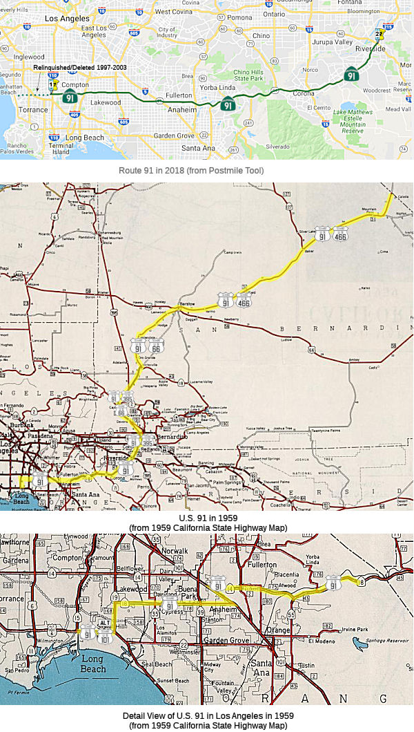 From Vermont Avenue at the eastern city limits of Gardena to Route 215 in
Riverside via Santa Ana Canyon.
From Vermont Avenue at the eastern city limits of Gardena to Route 215 in
Riverside via Santa Ana Canyon.
The relinquished former portions of Route 91 in the Cities of Gardena, Torrance, Lawndale, Redondo Beach, Manhattan Beach, and Hermosa Beach are not a state highway and are not eligible for adoption [as a state highway].
 Post 1964 Signage History
▸In 1963 (effective July 1, 1964), this route was defined as "Route 1 near Hermosa Beach to Route 395 via Santa Ana Canyon", and was signed as California Route 91.
 As part of the renumbering in 1964, signage for US 91
was truncated to end in Barstow instead of Long Beach. Note that post-1964
signed US 91 was legislatively Route 15 (I-15). See the linked
Gribblenation blog for more details, including links to maps and
pictures.
As part of the renumbering in 1964, signage for US 91
was truncated to end in Barstow instead of Long Beach. Note that post-1964
signed US 91 was legislatively Route 15 (I-15). See the linked
Gribblenation blog for more details, including links to maps and
pictures.
(Source: Gribblenation Blog (Tom Fearer), “Interstate 15; the Mojave Freeway from Barstow to the Nevada State Line”, April 2021)
In 1964, work continued on the Artesia Freeway -- particularly the
segment east from Alameda Street to the Santa Ana Freeway. This was to be
constructed in five segments. Completion of the Artesia Freeway east
of Alameda Street was expected during 1970. The existing portion of
the Artesia Freeway between Normandie Avenue and Alameda Street was
expressway grade. which was expected to be completed to full freeway
standards within six/seven years. The existing expressway grades of
the Riverside Freeway near Anaheim and Placentia had planned freeway
conversions. The Riverside Freeway was expected to reach Riverside
County by 1970.
(Source: Gribblenation Blog (Tom Fearer), "California State Route 14 (i)", 10/10/2023)
In December 1966, a project to convert Route 91 from expressway to
freeway between the Newport Freeway in Anaheim and Lemon St. in Fullerton
was completed, at a cost of $5.6 million.
(Source: CHPW, Jan/Feb 1967)
In 1967, coastal residents in any of the communities along the Route 1
proposed route in the South Bay started serious opposition after actual
construction began on Route 91. They cited a laundry list of reasons: the
high cost of land acquisition, loss of valuable beach property to the
roadway, close proximity to the ocean, and limited value of the proposed
roadway to north-south travelers. "The citizens of South Bay communities
who might be served by the freeway are presently served by both San Diego
and Harbor freeways," a 1967 Palos Verdes Peninsula News article read,
"and will be served by the Hawthorne freeway and that they do not require
additional freeways." State highway planners removed the Pacific Coast
Freeway (Route 1) from its master plan in April 1967.
(Source: Daily Breeze via MSN, 2/13/2023)
In 1967, the freeway was unconstructed W of I-5. By 1969, it was
completed between Route 19 and Cerritos. By 1970, it was complete from
Cerritos to the I-5. Route 91 was under construction from Route 19 west to
Route 7 (now I-710). Route 91 was under construction in the Yorba
Linda area.
(Source: Gribblenation Blog (Tom Fearer), "California State Route 14 (i)", 10/10/2023)
▸In 1969, Chapter 294 changed "Route 395" to "Route 15" (present-day I-215).
In 1974, US 91 was truncated to terminate in Brigham City, Utah,
eliminating the last remaining signage of US 91 in California
(Source: Gribblenation Blog (Tom Fearer), “Interstate 15; the Mojave Freeway from Barstow to the Nevada State Line”, April 2021)
In the early 1970s, meetings began to be held to reconsider its western
terminus. Hermosa Beach, after nixing the possibility of the freeway
stopping there, recommended extending Route 91 just to Hawthorne
Boulevard, on the route for the Torrance freeway that had been proposed in
1965. The Torrance City Council debated this question for the next two
years. In February 1972, Councilmember George Brewster was the only member
to vote against a resolution opposing building both the Artesia and
Torrance freeways through the city. In 1974, the Torrance freeway plan was
finally killed by Caltrans. By April 1974, Route 91 freeway construction
had been completed west through to Wilmington Avenue, though its
interchange with Route 7 (future I-710) freeway wouldn't be finished until
later that year.
(Source: Daily Breeze via MSN, 2/13/2023)
By 1975, all new freeway construction was halted because of the state's
budgetary woes and the intransigence of Gov. Jerry Brown regarding the
financing of further highway work. This suspended work on Route 91 within
a quarter mile of its proposed interchange with Route 11 (I-110). It took
another five years for construction to begin. At least it only took three
more years, instead of the four originally projected, to complete work on
the freeway interchange. That finally happened in June 1985.
(Source: Daily Breeze via MSN, 2/13/2023)
▸In 1977, Chapter 919 changed "Route 15" to "Route 194".
▸In 1982, Chapter 681 changed "Route 194" to "Route 215".
▸In 1994, Chapter 1220 clarified the terminus as "Route 215 in Riverside via Santa Ana Canyon."
▸In 1997, Assembly Bill 1561, Chapter 945 introduced a discontinuity when a portion of the route was turned over to the city of Gardena. Additionally, a provision has been added to the law to allow a portion of Route 91 to be relinquished to the city of Torrance. This made the definition:
▸In 1999, the state was permitted to relinquish the portion of Route 91 between Route 107 and Route 1 to the Cities of Hermosa Beach, Lawndale, Manhattan Beach, and Redondo Beach if the cities agree to accept it and the California Highway Commission approves (AB 1650, Ch 724, 10/10/99). This relinquishment was started in 1999:
▸In 2003, the legislative definition was changed once again to make the route continuous from the eastern limits of Gardena. (Assembly Bill 1717, Chapter 525, 9/25/2003).
▸In 2018, the state legislature passed a bill related to the HOV
lanes on Route 91. Specifically, the bill requires the Caltrans to report
to the transportation policy committees of the Legislature, on or before
January 1, 2020, on the feasibility and appropriateness of limiting the
use of high-occupancy vehicle lanes to high-occupancy vehicles and
eligible vehicles, as defined, only during the hours of heavy commuter
traffic on both Route 91 between I-15 and I-215 in the County of
Riverside, and Route 60 in the County of Riverside.
(Source: AB 91, Resolution Chapter 468, 9/18/2018)
 Pre 1964 Signage History
 Route 91 was originally US 91. US 91 was originally planned to
follow what is now US 95 into Las Vegas (and thus, some sections
correspond to the 1934 Route 195). The 1928 definition of the signed route
ran from the Nevada-California state line S of Jean NV via Baker to
Daggett (an exploration of why the original southern terminus of US 91 was
in Daggett may be found in the Gribblenation Blog on the subject). This routing followed the current I-15
alignment south from the Nevada state line, diverging from the current
I-15 alignment at the Ghost Town Road exit, headed south to Daggett via
Yermo-Daggett Road (and ending at US 66 there). In 1931, US 91 was
rerouted away from Daggett to follow Yermo Road and the I-15 alignment,
then along old US 466 (now Old Highway 58) west to First Avenue south into
Barstow (to end at US 66/Main Street). In 1947, US 91 was extended south
to Long Beach via US 66/US 395 and Route 18.
Note: For many of the details of US 91 between San Bernardino and the Nevada State Line, see the page for I-15.
The 1927 State of Nevada Department of Highways Map shows US 91 entering
California via NV 6 and using the Arrowhead Trail via Silver Lake. The
January 1928 California Highways & Public Works notes the alignment of
US 91 on LRN 31 in California. US 91 is stated to have enter
California via NV 6 through Jean towards Baker. From Baker US 91
followed LRN 31 southward to Daggett. This alignment would
have taken US 91/LRN 31 through Baker via Baker Boulevard.
(Source: Gribblenation Blog (Tom Fearer), “Former US Route 91 and US Route 466 in Baker”, April 2021)
The reason why the original 1928 definition of the route had the terminus in Daggett was explored in the Gribblenation Blog (Tom Fearer) "The Vague Original Southern Terminus of US Route 91 in the Californian Mojave Desert". The following is summarized from that blog entry; see the blog for more details, links to maps, and detailed mini-maps:
While the US Route System submitted in October of 1925 was fairly close to what was implemented in November of 1926 there was some significant differences. The most glaring or "well known" difference is that US 60 was planned on the routing which ultimately became US 66. Regarding US 91 the routing points were clear aside from the southern terminus in the Mojave Desert of California. In the October of 1925 submitted by the Joint Board on Interstate Highways US 91 is shown simply as ending at US 60. The US Route System with in California was approved by California Highway Commission with no changes recommended by January 1926. US Route 91 was stated to enter California and end near Needles, and this was shown in the January 1926 issue of California Highways & Public Works. The planned route of US 91 south from Great Falls, Montana to Las Vegas, Nevada is very clear in the 1925 Report. That said, south of Las Vegas the routing of US 91 was at best open to interpretation. Ultimately two existing roads south of Las Vegas to what was planned as US 60 were immediately available: the Los Angeles-Salt Lake Road that was part of the Arrowhead Trail southwest towards Daggett, or it's former alignment that was aligned directly south into California to Bannock. The older alignment of the Arrowhead Trail was also signed as the National Park-to-Park Highway and Evergreen National Highway. As the early US Route System was still in the works, it appeared that US 91 would ultimately follow NV 5 via the National Park-to-Park Highway and Evergreen National Highway to US 60 near Bannock. Ultimately what drove the decision to route US 91 via the Arrowhead Trail to Daggett appears to be the extension of LRN 31 from Barstow to the Nevada State Line by the California Legislature in 1925.
Maps published between 1926 show the evolution of the routing. A 1926 California State Highway map shows LRN 31 between Barstow and Nevada as unbuilt. The 1927 National Map Company Sectional Map shows US 91 entering California via NV 6 southwest over what had been the Arrowhead Trail / Los Angeles-Salt Lake Road. US 91 is shown traversing through the Mojave Desert via Francis Springs, Silver Lake, and Bitter Spring headed southwest to Daggett and US 66. By 1930, the Division of Highways Map of California shows US 91 routed onto a partially completed and largely unimproved route of LRN 31 from Barstow via Baker. The AASHO Database shows that the California State Highway Engineer sent a letter to the AASHO Executive Committee on January 24th, 1930 requesting that the south terminus of US 91 be moved from Daggett to Barstow. The existing US 91/LRN 31 between Yermo and Daggett was slated to be relinquished as a State Highway. According to a letter sent to the California State Highway Engineer dated November 11th, 1930 the AASHO Executive Committee approved changing the terminus of US 91 from Daggett to Barstow on May 25th, 1930.
The initially planned route of US 91 to US 66 near Bannock was adopted as LRN 146 in 1933. In 1934, this segment would become part of the first Route 195, which ultimately became US 95 in 1940 when it was extended to Blythe, California. The former alignment of US 91 on the Arrowhead Trail much of the roadway appears to still exist in Fort Irwin National Training Center.
US 91 rarely ran as just US 91:
In response to the construction of the US 101 freeway, LRN 178 was truncated on its eastern end to Manchester Blvd in 1953, and then to US 101 in 1957. The intent was to route US 91 along the a-building Riverside Freeway (Route 14, LRN 175). Seemingly dependent on the year and the mood of the Dept. of Highways, US 91 would take an appropriate N/S to the closest end of the Riverside Freeway -- be that Manchester/Bypass US 101, Brookhurst St, or State College. This sometimes involved US 91 signage on city streets. But the goal was to get US 91 on US 101 for the jog between Route 14 and Route 18 on Lincoln Ave. The segment along US 101 was part of LRN 174, defined in 1933.
After the 1953 truncation of LRN 178, W of the US 101/Orangethorpe Junction, US 91 then ran E along Orangethorpe, and later the Riverside Freeway, to Santa Ana Canyon, along Route 14 (present-day Route 91). This was part of LRN 175, defined in 1933. Present-day Route 91 follows pre-1964 Route 14 W from the junction with US 101 (now I-5). This is because the post-1964 Route 91 terminates in Hermosa Beach, not Long Beach like US 91 did.
From Santa Ana Canyon, the route ran NE cosigned with Route 18 to Riverside. By 1962, the Route 18 signage was dropped and it was signed as just US 91. This was part of LRN 43, defined in 1931. Riverside is the present-day eastern terminus of Route 91.
The 1927 State of Nevada Department of Highways Map shows US 91
entering California via NV 6 and using the Arrowhead Trail via Silver
Lake. The January 1928 California Highways & Public Works notes
the alignment of US 91 on LRN 31 in California. US 91 is
stated to have enter California via NV 6 through Jean towards
Baker. From Baker US 91 followed LRN 31 southward to
Daggett. This alignment would have taken US 91/LRN 31
through Baker via Baker Boulevard. The 1930 Division of Highways Map
of California shows US 91 routed onto a partially completed and
largely unimproved route of LRN 31 from Barstow via Baker.
(Source: Gribblenation Blog (Tom Fearer),
“Former US Route 91 and US Route 466 in Baker”, April 2021)
Originally, this segment was routed through Daggett. By 1931, the
route ran from N Barstow to Yermo, as evidence in a 1931 Conoco
California-Nevada map by H M Gousha (which shows US 91 going from
Yermo to north of Barstow on a road section constructed in 1930). In
January 1930, California Highways and Public Works noted that the
contractor “is making excellent progress with the grading on
their contract between Barstow and Yermo. This contract includes the
laying of oil-treated plant-mixed surfacing 20 feet wide.”
(Source: Email from Frank Aros)
The Los Alimitos Traffic Circle was the point where Route 1/Former Route 3/US 101A/US 91 and Route 19/US 91/Route18 came together. The Los Alamitos
Traffic Circle was located at the junction of State Street, Bennett Avenue
and Hathaway Avenue. 1934 Route 3 followed the entirety of LRN 60,
which by proxy took it through Los Alamitos Traffic Circle in Long
Beach. CA 3 was renumbered as US 101A in 1935; the 1964 renumbering
changed it to the current Route 1. Also meeting in the traffic circle was
Route 19/LRN 168, which in 1947 was cosigned with US 91. US 91 would also
be extended along US 101A to meet US 6. The Los Alamitos Traffic Circle
originally only had what is now the inner circle. The inner circle
transitioned the implied connection of Route 3/LRN 60 from Hathaway Avenue
to State Street (both were renamed by 1944 to Pacific Coast Highway). LRN 168 joined the traffic circle via Bennett Avenue, which is now Lakewood
Blvd. In 1942, the traffic circle was expanded and widened, with the
original plan being to have six highways enter it (however, only three
were constructed). The expansion added an outer ring which had been built
by the city of Long Beach and Los Angeles County. The original inner
Los Alamitos Traffic Circle was expanded to increase capacity on US 101A/LRN 60. In 1993, Caltrans reconfigured Los Alamitos Traffic Circle to
modern roundabout conventions. Route 19 was relinquished in the city
of Long Beach via AB 2132 Chapter 877 in 1998.
(Source: Gribblenation Blog (Tom Fearer), "Los Alamitos Traffic Circle; current California State Route 1/former US Route 101 Alternate and US Route 91", 2/7/2022)
LRN 178 was defined in 1933 as "Cerritos Avenue to [LRN 43] near Olive
via Anaheim" Cerritos Avenue was later renamed Lakewood Avenue; LRN 43 was
to become Sign Route 18 (briefly) and then US 91. The route followed
Carson Street, Lincoln Avenue and Center Street (now Lincoln Avenue in
Anaheim) between Lakewood Ave (Sign Route 19/LRN 168) and LRN 43. In 1934,
this became part of Sign Route 18. In 1947, AASHO approved the extension
of US 91 from Barstow to Long Beach. The extension of US 91 to Long
Beach was created from a multiplex of LRN 43/Sign Route 18 (which became
US 91), LRN 178/Sign Route 18 along Lincoln Avenue, Sign Route 19/LRN 168
to Los Alamitos Traffic Circle, and west on US 101A/LRN 60 on Pacific
Coast Highway. In 1953, LRN 178 was truncated to the new mainline of
US 101 at Manchester Avenue/LRN 174. This removed the segment of LRN 178 between US 101/LRN 174 east through Anaheim to US 91/LRN 43. At
this tims, US 91 and Sign Route 18 were still routed along Center Street
in Anaheim and Olive. By 1956, US 91/Sign Route 18 were rerouted
from the eastern terminus of LRN 178 onto US 101/LRN 174 and then along
Sign Route 14/LRN 175 towards US 91/LRN 43 in Santa Ana Canyon. In
1957, the legislature clarified the end points of LRN 178 as "LRN 168
(Sign Route 19) near Lakewood and LRN 174 (US 101) near Anaheim." In 1961,
Sign Route 18 was truncated to San Bernardino, leaving US 91 as the only
Sign Route on LRN 178. In 1963, US 91 was truncated to Barstow; in 1964,
former US 91 in Santa Ana Canyon and along Sign Route 14 became Route 91,
and LRN 178 became Route 214. Route 214 was to be deleted once the Route 91 freeway was completed.
(Source: Gribblenation Blog (Tom Fearer), "Former California State Route 214 (former California State Route 18 and US Route 91)", 6/14/2023)
During 1933, LRN 178 and LRN 174 were defined as highways passing through
Anaheim. LRN 178 was defined as from "Cerritos Avenue to LRN 43 near
Olive via Anaheim." LRN 174 was defined as "LRN 60 via Manchester
Avenue to LRN 2/US Route 101 near Miraflores." LRN 178 (Sign Route 18) would pass through the city of Anaheim via Center Street (partially
now Lincoln Avenue), whereas LRN 174 (Sign Route 10) was part of the then
unfinished Manchester Boulevard Extension. By 1942, Sign Route 10
had been truncated to an eastern terminus at US 101 Bypass/Sign Route 19
at Rosemead Boulevard in Downey. On July 1, 1947, the AASHO Executive
Secretary notified the California State Highway Engineer that California's
request to extend US 91 from Barstow to Long Beach had been approved; this
extension brought it through Anaheim along Center Street via a multiplex
of Sign Route 18/LRN 178. In 1953, the eastern terminus of LRN 178 was
truncated to the new mainline routing of US 101 along Manchester Boulevard
in Anaheim. Despite LRN 178 being relinquished between US 101/LRN 174 and LRN 43, it was still signed as US 91/Sign Route 18 through Anaheim
via Center Street. By 1956, US 91 and Sign Route 18 were realigned
onto Sign Route 14/LRN 175 north of downtown Anaheim. The interim
routing of US 91/Sign Route 18 from Lincoln Avenue followed US 101/Manchester Boulevard, Orangethorpe Avenue, Cypress Avenue (now State
College Boulevard) and a completed segment of the Riverside (Orangethorpe)
Freeway (east of LRN 180). In 1956, the Riverside Freeway (Houston
Expressway) (Sign Route 14/US 91/Sign Route 18/LRN 175) opened east of LRN 180/Cypress Avenue to Santa Ana Canyon. By 1957, Sign Route 18 and US 91
were realigned onto the Stanton Avenue Extension along Sign Route 39/LRN 171 in Buena Park. Both highways briefly multiplexed US 101 towards
Sign Route 14/LRN 175 on Orangethorpe Boulevard. In 1962, Sign Route 18
was truncated from Long Beach to San Bernardino. This truncation removed
it from US 91/Sign Route 14/LRN 175 on the Riverside Freeway north of
downtown Anaheim.
(Source: Gribblenation Blog (Tom Fearer), "Former US Route 101, US Route 91, California State Route 10 and California State Route 18 in Anaheim", 9/26/2023)
See the page on Route 14 (Sign Route 14) for the history of Sign Route 14.
However, the post-1964 definition of Route 91 consisted of only two of these LRNs: LRN 175 between Hermosa Beach and Santa Ana Canyon (Sign Route 14), and LRN 43 (US 91, Sign Route 18) from Santa Ana Canyon to Riverside.
On AARoads, Scott Parker noted:
(Source: Scott Parker on AARoads, “Re: Early US 91 south terminus”, 11/6/2020)
Although there were several iterations of US 91 alignments over the years, in SoCal it could be signed continuously on appropriate existing streets from the corner of PCH and Atlantic in Long Beach all the way out to Tustin Ave. and "Old" Santa Ana Canyon Road in east Anaheim, Santa Ana Canyon Road in Anaheim Hills (as far east as Yorba Linda Blvd.), and the continuous run of 6th Street in Corona, Magnolia Ave., Market St., and North Main Street in Riverside -- but taking it over Russell Street (now simply a city street dead-ending at the present Route 91 freeway) would today be historically accurate but pointless. From there up to Highgrove the old US 91 alignment is buried under the Route 91 and I-215 freeways; it diverges onto surface streets again at the La Cadena exit, with the alignment up to Mount Vernon in San Bernardino being intact through Colton -- with two 90-degree turns onto old US 70/US 99 -- so that would tie in with the Cajon Blvd. alignment that is discussed in the Historic US 66 thread. Of course, US 91 historical signage could be "multiplexed" with that of US 66 all the way from Victorville to Barstow before breaking away in the center of that town. But beyond that, I-15 mostly lies atop historic US 91 except for a few miles near Calico and the business loop through Baker.
The portion between the junction with Imperial Highway in the Anaheim Hills and I-15 (Temescal
Canyon, former Route 71) was part of the planned Imperial Highway.
The name "Imperial" refers to the Imperial Valley, which took its name
from the Imperial Land Co., a subsidiary of the California Development
Company charged with reclaiming the water-starved but arable land east of
San Diego for agricultural purposes in the early 1900s. The company began
building canals in 1900, diverting water from the Colorado River for
irrigation, and forming the Salton Sea in the process. The Los Angeles
area wanted to patch together a superhighway that would stretch from the
Pacific all the way to Brawley in the Imperial Valley, a distance of 215
miles; the route was later extended a few miles farther south to El
Centro. The most route roughly followed the old Butterfield Stage overland
route, established in 1858: across the desert (Route 78) and along
today’s Route 79 to Temecula, where it headed on to Corona via Lake
Elsinore and Temescal Canyon (Route 71, later I-15). There the road turned
left down the Santa Ana Canyon on its way to Yorba Linda (present-day
Route 91) and La Habra (present-day Route 90), then across Los Angeles
County to meet the sea at El Segundo (as Imperial Highway, although it is
paralleled by I-105). The extension to Brawley was along Route 86 The
early Imperial Highway plans involved connecting a patchwork assortment of
roads of varying length and quality. In 1912, a group of Los Angeles
boosters informally known as the Committee of One Hundred, working with
Los Angeles, San Bernardino, Orange, Riverside and Imperial counties,
settled on a route along the edge of the inland Salton Sea that completely
bypassed San Diego County, from which Imperial County had been split off
in 1907. The Los Angeles section of road would be mostly a straight shot
from LAX to Anaheim, where the proposed road would dip south diagonally
before eventually reaching the Imperial Valley. By the 1920s, the efficacy
of the Imperial Highway concept had become apparent, and a new and more
forceful private group, the Imperial Highway Association, was formed in
1929 to encourage the regions involved to mount a fully cooperative
effort, including working closely with San Diego County, to get the job
done. The association adopted an official route for a more streamlined,
uniform highway in 1931 that ran slightly west of the earlier Salton Sea
route. The improved roadway, now referred to informally as “the
Cannon Ball Road,” would eliminate tight right angle turns that
slowed trucks, smooth and widen the various roadways involved, and have
new bridges where necessary. A major section in Yorba Linda was completed
in 1937. Two-lane portions of the highway through Inglewood had to be
expanded to four. A bridge over the Los Angeles River, completed in
1951, eliminated a crucial bottleneck; it replaced an old one that
collapsed in 1948. The final section of the Imperial Highway as envisioned
by the association was completed, and it was dedicated a scenic highway in
a ceremony on the Imperial-San Diego county border in December 1961. Of
its 220 total miles, 77 were county roads, with the rest being state
highways. The cost to complete the project was estimated at $16 million
(about $138 million in 2020 dollars). In 1965, Caltrans planned a new
freeway along the path of Imperial Highway, from LAX to Norwalk. It opened
in 1993 as I-105, though Imperial Highway itself remained in place, if
somewhat less crucial than it once was. Through Orange County, Imperial
Highway was Route 90. Major chunks of the roadway through Riverside and
San Diego counties were subsumed by newer freeways and highways over the
years. The 41-mile Los Angeles stretch, which passes through El Segundo,
Hawthorne, Inglewood, South Los Angeles, Lynwood, South Gate, Downey,
Norwalk, Santa Fe Springs and La Mirada, retains the original Imperial
Highway name, as does a section of Route 86 in El Centro (also known as
Imperial Avenue).
(Source: Daily Breeze, “South Bay History: Imperial Highway once figured as part of a superhighway plan”, 3/29/2021; Orange County History “The Imperial Highway”, 2011)
 Status
Note that Route 91 once had its own twitter account. The updates came directly from Fernando Chavarria, OCTA’s community relations officer, who provides the public with firsthand knowledge and up-to-the-minute construction updates. However, it hasn't tweeted since 2016.
The 2013 Traversable Highways report notes that Riverside County line to Route 91/Route 55, Route 91 Express Lanes will revert to the State when the Franchise Agreement expires. The Franchise Agreement between Caltrans and OCTA was extended to a date no later than December 31, 2065, per SB 1316.
In August 2011, the CTC approved $1,800,000 in SHOPP funding, programmed in Fiscal Years 2012-13 and 2013-14, for repairs in the city of Los Angeles, at the Route 110 connector Bridge #53-2549H (~ LA R6.448) and in Long Beach at Route 710 Bridges #53-2142K and 53-2144K (~ LA R11.583), that will rehabilitate three bridges to extend the service life of the structures.
In October 2021, the CTC approved for future consideration of funding
07-LA-91, PM R7.00/R11.04. SR-91 Central Avenue to Acacia Court
Improvement Project. Reduce congestion and construct mobility and
safety improvements on Route 91 in Los Angeles County. (MND) (EA
35920) (FTIP). This project is located on Route 91 in the cities of
Compton and Carson, between Central Avenue and Acacia Court, in Los
Angeles County. The Department proposes to make improvements that include
a Collector-Distributor (C-D) road with a concrete-barrier-separated
system that would run parallel to the Route 91 mainline, in each
direction, to connect the Central Avenue and Wilmington Avenue
on/off-ramps. The C-D road would consolidate multiple access points from
the Central Avenue, Wilmington Avenue, and Acacia Court interchanges into
a single access point, halving the number of ingress/egress points on the
freeway mainline, and redirecting the short and nonstandard weaving areas
from the freeway mainline to the C-D road. This project is fully funded
with local funds and is currently programmed in the 2020 Federal
Transportation Improvement Program (FTIP) for a total of $20,455,000,
which includes Preliminary Engineering. Construction is estimated to begin
in 2023-24.A copy of the MND has been provided to Commission staff.
The project will result in less than significant impacts to the
environment after mitigation.
(Source: October 2021 CTC Agenda, Agenda Item
2.2c.(1))
In October 2021, the CTC approved the following allocation for
construct/construction support phases: $4,389,000. 07-LA-91 R11.8. PPNO
07-4967; ProjID 0716000017; EA 31910. Route 91 In Long Beach, at the
northbound Route 710 to eastbound Route 91 connector, below Artesia
Boulevard Overcrossing № 53-0820 and E91-N710 Connector Overcrossing
№ 53-2241G. Outcome/Output: Lower profile of connector
to achieve standard vertical clearance, prevent structural damage, and
improve safety. Allocation: CON ENG $2,073,000; CONST $3,230,000.
(Source: October 2021 CTC Agenda, Agenda Item
2.5b.(1) #11)
Eastbound Route 91/Atlantic Avenue to Cherry Avenue Auxiliary Lane Improvements Project (07-LA-91, PM R11.8/R13.2)
 In August 2021, the CTC approved for future consideration
of funding 07-LA-91, PM R11.8/R13.2. Eastbound Route 91/Atlantic
Avenue to Cherry Avenue Auxiliary Lane Improvements Project.
Develop and implement an auxiliary lane to enhance safety conditions,
reduce congestion, and improve freeway operations on eastbound Route 91 in Los Angeles County. (MND) (PPNO 5496) (STIP). This project is
located on Route 91 from I-710 to Cherry Avenue undercrossing. The
Department, in cooperation with the Los Angeles County Metropolitan
Transportation Agency and the Gateway City Council of Government, proposes
to develop and implement an 0.86 mile auxiliary lane on eastbound Route 91
within a 1.4 mile segment from the southbound I-710 interchange connector
to eastbound Route 91, to Cherry Avenue, including improvements to the
Atlantic Avenue onramp and Cherry Avenue offramp. The purpose of the
project is to enhance safety conditions, reduce congestion, and improve
freeway operations on both the eastbound Route 91 mainline and ramps. The
project is currently programmed in the 2020 STIP for a total of
$94,750,000, which includes local funds and TCEP funds. Construction is
estimated to begin in 2023-24. The scope, as described for the preferred
alternative, is consistent with the project scope as programmed by the
Commission in the 2020 STIP. A copy of the MND has been provided to
Commission staff. The project will result in less than significant
impacts to the environment after mitigation. The following resource
areas may be impacted by the project: noise, and geology and soils.
Avoidance and minimization measures will reduce any potential effects on
the environment. These measures include, but are not limited to,
sound-control devices on internal combustion equipment, planting of
non-water succulent plants after finished slope grading, and preparation
of a quality assurance/quality control plan that details requirements for
observation, monitoring, and testing by a geotechnical engineer or
engineering geologist prior to construction. As a result, an MND was
completed for this project.
In August 2021, the CTC approved for future consideration
of funding 07-LA-91, PM R11.8/R13.2. Eastbound Route 91/Atlantic
Avenue to Cherry Avenue Auxiliary Lane Improvements Project.
Develop and implement an auxiliary lane to enhance safety conditions,
reduce congestion, and improve freeway operations on eastbound Route 91 in Los Angeles County. (MND) (PPNO 5496) (STIP). This project is
located on Route 91 from I-710 to Cherry Avenue undercrossing. The
Department, in cooperation with the Los Angeles County Metropolitan
Transportation Agency and the Gateway City Council of Government, proposes
to develop and implement an 0.86 mile auxiliary lane on eastbound Route 91
within a 1.4 mile segment from the southbound I-710 interchange connector
to eastbound Route 91, to Cherry Avenue, including improvements to the
Atlantic Avenue onramp and Cherry Avenue offramp. The purpose of the
project is to enhance safety conditions, reduce congestion, and improve
freeway operations on both the eastbound Route 91 mainline and ramps. The
project is currently programmed in the 2020 STIP for a total of
$94,750,000, which includes local funds and TCEP funds. Construction is
estimated to begin in 2023-24. The scope, as described for the preferred
alternative, is consistent with the project scope as programmed by the
Commission in the 2020 STIP. A copy of the MND has been provided to
Commission staff. The project will result in less than significant
impacts to the environment after mitigation. The following resource
areas may be impacted by the project: noise, and geology and soils.
Avoidance and minimization measures will reduce any potential effects on
the environment. These measures include, but are not limited to,
sound-control devices on internal combustion equipment, planting of
non-water succulent plants after finished slope grading, and preparation
of a quality assurance/quality control plan that details requirements for
observation, monitoring, and testing by a geotechnical engineer or
engineering geologist prior to construction. As a result, an MND was
completed for this project.
(Source: August 2021 CTC Agenda, Agenda Item
2.2c.(1))
In June 2022, the CTC approved an allocation for the
following SB1 Trade Corridor Enhancement Program (TCEP) projects, on the
State Highway System: $48,332,000. 07-LA-91 11.8/13.2. PPNO 07-5496;
ProjID 0718000343; EA 35460. EB SR-91 Atlantic Ave to Cherry Ave. Aux
Lane Project. In the City of Long Beach on Route 91 from I-710 to
Cherry Avenue undercrossing. The proposed improvements consist of adding
one auxiliary lane in the eastbound direction, extending the outside #5
lane beyond the Atlantic Ave EB off-ramp to Cherry Ave. then dropping it
before the Cherry Ave. undercrossing, and widening the Orange Ave. and
Walnut Ave. undercrossings. Future consideration of funding approved under
Resolution E-21-80; August 2021. Contribution from other sources:
$38,801,000. As part of this allocation request, LACMTA is requesting to
extend the period of project completion an additional 6 months beyond the
36 month deadline due to plant establishment period prior to contract
acceptance. LACMTA is requesting a minor outcomes/outputs change to what
was originally proposed in the original application due to an entry error.
Originally, 1.4 miles of Aux.lanes were shown in the ePPR. The corrected
outcomes will deliver.86 miles of Aux. lanes that is consistent with the
project report. This is not a reduction in scope, it's a correction to an
entry error that was made in the ePPR. Allocation: TCEP-R/21-22
CONST $29,000,000; TCEP-S/21-22 CONST $19,332,000.
(Source: June 2022 CTC Agenda, Agenda Item
2.5s.(7)) #2
In September 2023, it was reported that the Metro board
Construction Committee is recommending the board approve $65 million for
construction management services for two Metro/Caltrans Route 91 Freeway
widening projects. The two Route 91 Freeway expansion projects, both part
of Metro's Gateway Cities SR-91/I-605/I-405 “Hot Spots”
Program, are located in already pollution-burdened communities in
Southeast L.A. County. Metro's staff report notes that these highway
widenings are fully funded via Measure R sales tax and state TCEP (Trade
Corridor Enhancement Program), though construction management will be paid
by both Measures R and M revenue. In this project, Metro and Caltrans plan
to add one more eastbound lane on Route 91 for just under one mile from
Atlantic Avenue to Cherry Avenue, in north Long Beach. The added lane is
an "auxiliary" lane - a car lane that extends from an onramp to the next
off-ramp. Metro and Caltrans are breaking up lots of L.A. County freeway
widening projects into dozens of less than one mile long aux lane segments
(on Route 91, I-405, I-605, and likely elsewhere), as that type of
widening is exempt from full environmental review and environmental
mitigation. Metro and Caltrans' eastbound Route 91 widening was approved
via a 2021 FONSI. The widening does not take out any homes, but expands
the freeway into an existing tree-lined right-of-way owned by Caltrans.
Metro and Caltrans expect this Route 91 Freeway widening to cost $88-95
million - roughly $100 million per mile.
(Source: Streetsblog LA, 9/19/2023)
Route 605 / Route 91 Interchange Improvements (07-LA-91, PM 16.9/19.8)
 The SAFETEA-LU act, enacted in August 2005 as the
reauthorization of TEA-21, provided the following expenditures on or near
this route:
The SAFETEA-LU act, enacted in August 2005 as the
reauthorization of TEA-21, provided the following expenditures on or near
this route:
In January 2018, it was reported that Metro and
Caltrans District 7, in collaboration with the Gateway Cities Council of
Governments (GCCOG), are proposing to make improvements along westbound
Route 91, between the I-605/Route 91 (091 LA R16.935) Interchange and
Shoemaker Avenue (091 LA R19.818), and at the I-605 northbound exit to
Alondra Boulevard (605 LA R5.834). Proposed improvements in the Westbound SR-91 Improvement Project include adding auxiliary lanes, one new general purpose lane in the westbound direction, a lane at the I-605/Route 91 interchange off-ramp, enhancing freeway entrance and exit ramps, and
additional improvements on the arterial streets in the vicinity. Technical
studies for the project are still underway as of January 2018.
(Source: Metro "The Source", 1/25/2018)
The 2018 STIP, approved at the CTC March 2018 meeting, appears to allocate $22,000K in Advance Program Development Element funds for PPNO 5388, Rt 91 WB, Shoemaker Ave-Rt 605 IC, for PS&E in FY18-19.
In April 2018, it was reported that Metro was applying
for TCRP (Trade Corridor Relief Program) funds in addition to SB1 funds
for Route 605 / Route 91 Interchange Improvement project.
(Source: Metro The Source, 4/19/2018)
In March 2019, the CTC approved for future
consideration of funding a project is located on Route 91 from Shoemaker
Avenue to I-605, and on I-605 from Alondra Boulevard to the I-605/Route 91
Interchange in the cities of Cerritos and Artesia (07-LA-91, PM 16.9/19.8,
07-LA-605, PM 5.0/5.8). The purpose of the project is to reduce congestion
and improve freeway operations, safety and local and system interchange
operations. The proposed project includes additional freeway mainline
capacity leading to westbound Route 91 connector ramp to northbound and
southbound I-605, improvements to freeway entrance and exit ramps in the
westbound direction of Route 91 and operational improvements for the
northbound I-605 at the Alondra Boulevard off-ramp. This project proposes
to address the inadequate capacity of the existing two-lane connector for
westbound Route 91 to I-605. This project is fully funded and currently
programmed in the 2018 State Transportation Improvement Program (STIP) for
approximately $187.8 million. Construction is estimated to begin in 2022.
The scope, as described for the preferred alternative, is consistent with
the project scope programmed by the Commission in the 2018 STIP. The CTC
also approved an allocation of $26,000,000 for the multi-funded
locally-administered Senate Bill 1 (SB 1) Trade Corridors Enhancement
Program (TCEP)/State Transportation Improvement Program (STIP) Route 605/Route 91 Interchange Improvement: Gateway Cities Freight Crossroads
Project (PPNO 5388), on the State Highway System, in Los Angeles County.
(Source: March 2019 CTC Minutes, Agenda Item 2.2c.(1); March2019
CTC Minutes Agenda Item 2.5s.(7))
In December 2020, it was reported that the CTC approved
$118 million in Trade Corridor Enhancement Program funds for Route 91
Goods Movement Corridor Projects. The money will help modify the
I-605/Route 91 interchange to improve and add capacity to the connector
ramps, add an auxilliary lane on eastbound Route 91 between I-710 and
Cherry Avenue and help bring Route 91 up to current freeway standards.
(Source: Metro "The Source" 12/2/2020)
In September 2023, it was reported that the Metro board
Construction Committee is recommending the board approve $65 million for
construction management services for two Metro/Caltrans Route 91 Freeway
widening projects. The two Route 91 Freeway expansion projects, both part
of Metro's Gateway Cities SR-91/I-605/I-405 “Hot Spots”
Program, are located in already pollution-burdened communities in
Southeast L.A. County. Metro's staff report notes that these highway
widenings are fully funded via Measure R sales tax and state TCEP (Trade
Corridor Enhancement Program), though construction management will be paid
by both Measures R and M revenue. In the Route 91/Route 605 interchange
project, Metro and Caltrans plan to add one additional lane for nearly
four miles between Shoemaker Avenue and the I-605 Freeway exit at Alondra
Boulevard. The widening is located in the cities of Artesia and Cerritos.
In this project's 2019 environmental clearance, a "finding of no
significant impact" (FONSI), Metro and Caltrans had approved tearing down
nearly a dozen homes and businesses in the city of Artesia. In 2021, under
pressure to stop taking out homes to widen various freeways, Metro and
Caltrans backed off the approved demolitions, instead planning to take
only "sliver acquisitions" from various parcels including two parks and a
high school. Earlier in 2023, Metro approved using eminent domain to
secure a sliver parcel for the project. The sliver is located on the south
side of Route 91; the widening project is on the north side of Route 91.
Metro staff state that the land is needed to demolish and rebuild (widen,
lengthen) the Shoemaker Avenue Bridge over Route 91. Metro estimates that
adding this 4-mile long westbound lane will cost $162.4 million - about
$40 million per lane-mile.
(Source: Streetsblog LA, 9/19/2023)
Orange County — County Line to Route 57
In August 2011, the CTC approved $21,457,000 in SHOPP funding in the cities of La Palma, Buena Park, Anaheim and Fullerton, from the Los Angeles County Line to Lakeview Avenue, that will resurface mainline and ramps on 128 lane miles of pavement to improve safety and ride quality. Project will replace damaged slabs, grind pavement, overlay existing asphalt pavement and ramps, and install concrete termini at ramps.
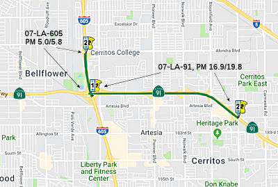
State Route 91 Improvement Project between State Route 57 and State Route 55 (12-Ora-91, PM 4.7/R10.8, 12-Ora-57, PM 15.5/16.2, 12-Ora-55, PM 17.4/R17.9)
In August 2020, the CTC approved for future
consideration of funding a project is located on Route 91 in Orange County
on a six-mile corridor through the cities of Anaheim, Fullerton, Orange,
and Placentia. The Department proposes to improve capacity and reduce
congestion, as well as reduce weaving and merging between successive ramps
at several interchanges. The proposed improvements would include the Route 91 freeway mainline widening, primarily in the eastbound direction,
and modifications to various interchanges, connectors, ramps, and
intersections on Route 91, Route 57, and Route 55. This project is
currently funded through Project Approval and Environmental Document and
Plans, Specifications, and Estimates for $28,400,000 in federal funds
through the Surface Transportation Block Grant Program and local funds.
Total project cost is estimated to be $352,400,000. Construction is
estimated to begin in 2023-24.
(Source: August 2020 CTC Agenda, Agenda Item
2.2c.(1))
Route 57 Auxiliary Lanes (~ ORA R3.855L to ORA 6.015, R9.193 to ORA R18.869)
In June 2007, the OCTA outlined a 5-year plan for the use of the 2nd Measure M funds that included adding lanes on Route 91 between I-5 and Route 57 (~ ORA R3.855L to ORA 6.015) and between Route 55 and the Riverside County border (~ ORA R9.193 to ORA R18.869); adding lanes on I-405 between I-605 and Route 55; a new NB lane on Route 57 between Orangewood Avenue and Lambert Road.
In August 2010, the CTC approved for future consideration of funding a project that will construct an additional westbound lane from Route 5 to Route 57 (~ ORA R3.855L to ORA 6.015) in the cities of Anaheim and Fullerton. The project is programmed in the Trade Corridors Improvement Fund and includes local funds. Construction is estimated to begin in Fiscal Year 2012-13. Total estimated project cost is $73,400,000 for capital and support. The scope as described for the preferred alternative is consistent with the project scope set forth in the proposed project baseline agreement.
In September 2012, the CTC approved $34,950,000 in SHOPP funding on Route 91 for the Route 91 Auxiliary Lane Connection. In Fullerton and Anaheim, westbound from Route 57 to I-5. Construct a lane on existing auxiliary lanes through interchanges to form a continuous fourth lane. (TCIF Project 34) (Future Consideration of Funding – Resolution E-10-75, August 2010.) (Contributions from other sources: $13,050,000.) Outcome/Output: Construct 4.6 miles of new lanes. Hours of congestion are decreased approximately 10 percent on the freeway.
In February 2012, the CTC updated the project. The intent of the project is to connect existing auxiliary lanes through interchange from Route 57 to I-5 project will create a fourth mixed-use lane on westbound Route 91 by connecting existing auxiliary lanes through interchanges. The project is currently programmed with $34,950,000 in TCIF funds and $35,750,000 in local measure funds. The project is scheduled for construction in December 2012. The amendment moved the replacement planting scope to a separate project funded with $2,455,000 in local measure funds. It also updated the funding plan for support and capital components funded with local measure funds. Construction is currently scheduled to end in October 2016.
In April 2016, it was reported that a six-mile stretch
of westbound Route 91 had opened, providing new general-purpose and
auxiliary lanes and widened bridges and ramps. Located between Route 57
and I-5, the improved area includes four miles of new general-purpose
lanes in the westbound direction and auxiliary lanes that allow traffic to
more smoothly enter and exit the freeway. The improvements were led by
OCTA and Caltrans. The $61 million improvement project was paid for with a
combination of state Prop. 1B and local funds from Measure M, Orange
County’s half-cent sales tax for transportation improvements.
(Source: OCTA Blog, 4/6/2016)
Orange County — Route 57 to Route 55
Tustin Ave Aux Lane
 In August 2011, the CTC approved for future consideration of funding a project to extend a westbound lane from
the northbound Route 55/westbound Route 91 connector (~ ORA R9.216)
through the Tustin Avenue interchange (~ ORA 8.4) and reconstruct the
westbound auxilliary lane from east of the northbound Route 55/westbound
Route 91 connector to the Tustin Avenue off-ramp. Construction is expected
to begin in FY 2014-2015.
In August 2011, the CTC approved for future consideration of funding a project to extend a westbound lane from
the northbound Route 55/westbound Route 91 connector (~ ORA R9.216)
through the Tustin Avenue interchange (~ ORA 8.4) and reconstruct the
westbound auxilliary lane from east of the northbound Route 55/westbound
Route 91 connector to the Tustin Avenue off-ramp. Construction is expected
to begin in FY 2014-2015.
In June 2016, it was reported that the Route 91
Auxiliary Lane Project was completed, which extended an auxiliary lane at
the freeway’s interchange with the northbound Costa Mesa Freeway
(Route 55) and added a bypass lane at Tustin Avenue. The cost of this
project was approximately $41.9 million.
(Source: Voice of OC, 6/9/2016)
Orange County — Route 55 to Route 241
Route 91 Express Lanes (~ ORA R9.252 to ~ ORA R16.004)
 Has parallel (toll) express lanes from Route 55
(~ ORA R9.252) to the junction with Route 241 in Orange County (~ ORA
R16.004), opened in 1996. These toll roads are the subject of contention
due to a non-compete agreement, which prevents the public transportation
agencies from upgrading their highway or adding lanes without compensating
the company. This resulted in a payment of $4M in public funds for the
rights to ease a bottleneck along a 1,000 yard stretch of freeway just
each of Coal Canyon Road. In order to speed improvements on this congested
stretch of highway, the OCTA agreed on 4/19/2002 to purchase the 10 miles
of toll lanes for $207.5M. Under the agreement, the Orange County
Transportation Authority (OCTA) will assume the toll road's $135M debt,
and make a one-time payment of $72.5M (which includes the $4M Coal Canyon
Road improvement payment). Although touch and go in the state assembly, a
bill authorizing this purchase was approved on 9/18/2002. (Assembly Bill
1010, Chapter 688, 9/18/2002). Note that the tolls on these lanes are
adjusted quarterly as part of the Orange County Transportation Authority's
congestion management pricing policy. It calls for dropping and raising
tolls based on traffic demand. Traffic volumes are monitored daily and
adjusted quarterly. An example of this adjustment was in January 2010,
when the toll for those traveling in the eastbound direction on Wednesdays
from 3 p.m. to 4 p.m. saw the toll drop from $5.45 to $4.95, and those
travelling on Fridays from 2 p.m. to 3 p.m. saw the toll drop from $4.10
to $3.60.
Has parallel (toll) express lanes from Route 55
(~ ORA R9.252) to the junction with Route 241 in Orange County (~ ORA
R16.004), opened in 1996. These toll roads are the subject of contention
due to a non-compete agreement, which prevents the public transportation
agencies from upgrading their highway or adding lanes without compensating
the company. This resulted in a payment of $4M in public funds for the
rights to ease a bottleneck along a 1,000 yard stretch of freeway just
each of Coal Canyon Road. In order to speed improvements on this congested
stretch of highway, the OCTA agreed on 4/19/2002 to purchase the 10 miles
of toll lanes for $207.5M. Under the agreement, the Orange County
Transportation Authority (OCTA) will assume the toll road's $135M debt,
and make a one-time payment of $72.5M (which includes the $4M Coal Canyon
Road improvement payment). Although touch and go in the state assembly, a
bill authorizing this purchase was approved on 9/18/2002. (Assembly Bill
1010, Chapter 688, 9/18/2002). Note that the tolls on these lanes are
adjusted quarterly as part of the Orange County Transportation Authority's
congestion management pricing policy. It calls for dropping and raising
tolls based on traffic demand. Traffic volumes are monitored daily and
adjusted quarterly. An example of this adjustment was in January 2010,
when the toll for those traveling in the eastbound direction on Wednesdays
from 3 p.m. to 4 p.m. saw the toll drop from $5.45 to $4.95, and those
travelling on Fridays from 2 p.m. to 3 p.m. saw the toll drop from $4.10
to $3.60.
![[Toll Chart]](maps/091-tolls.jpg) In December 2007, it was announced that in January 2008,
the toll on Fridays on the eastbound 91 Express Lanes will rise to $10;
this rise comes nine months after the boost to $9.25. It will be in effect
from 3 to 4 p.m. This is an example of congestion pricing —
additionally, the eastbound toll during the same 3 to 4 p.m. hour will
increase from $4.95 to $5.95 on Wednesdays and from $4.95 to $5.70 on
Thursdays. As of 2007, Route 91 was one of the most congested highways in
Southern California. More than 320,000 vehicles use the freeway each day
to commute between Orange and Riverside counties.
In December 2007, it was announced that in January 2008,
the toll on Fridays on the eastbound 91 Express Lanes will rise to $10;
this rise comes nine months after the boost to $9.25. It will be in effect
from 3 to 4 p.m. This is an example of congestion pricing —
additionally, the eastbound toll during the same 3 to 4 p.m. hour will
increase from $4.95 to $5.95 on Wednesdays and from $4.95 to $5.70 on
Thursdays. As of 2007, Route 91 was one of the most congested highways in
Southern California. More than 320,000 vehicles use the freeway each day
to commute between Orange and Riverside counties.
In December 2011, the results of a survey regarding use of the toll lanes was released. Typical users of the toll lanes are fully employed, relatively well-off men who pay the fees to avoid long traffic delays when they drive to visit friends and relatives or for recreational outings. Those least likely to pay are students, the unemployed and those earning less than $25,000 a year. Commuters heading to and from work constitute less than half of those who use the toll lanes. Overall, 90 percent of those who use the toll lanes said they "were generally satisfied with their experiences," and they estimated they shave about half an hour from their travel times by paying the tolls. The average monthly toll bill for those surveyed was $57.55. More details can be found in the Voice of OC article.
In December 2016, it was reported that for the first
time in its 21-year history, the entire 91 Express Lanes has been repaved.
Working together, agencies, project management partners and the
construction contractor finished major repaving in only 8 weekends rather
than the 10 weekends originally scheduled. The project paved 20 miles,
restriped 110 miles, used 113,000 tons of asphalt and ground and replaced
375,000 square yards of pavement. The project was paid for entirely by the
91 Express Lanes Capital Reserve Fund, the 91 Express Lanes pavement
project will extend the pavement’s lifespan for decades while
continuing to provide a safe, smooth commute. Periodic nighttime closures
will be needed to complete the finishing touches. In addition to the
pavement work, the project includes replacing six changeable message
signs, replacing channelizers, completing electrical work and replacing
pavement markers. The entire project is expected to be completed by
January 2017.
(Source: OCTA Blog, 12/6/2016)
In January 2020, it was reported that in 2019, the
section administered by OCTA recorded 17.5 million trips, a 4.9 percent
increase compared to 2018. Gross potential toll revenue reached $51.9
million, up 4.4 percent since 2018. Additionally, in 2019, OCTA installed
new transponders and updated in-lane technology to support them, planned
and funded a state-of-the-art back office system to streamline processing
for the ever-growing customer base, improved safety by doubling the number
of California Highway Patrol (CHP) officers, and continued in its mission
to expand and improve Route 91 for all those who travel in the region. In
2020, OCTA is rolling out transponders equipped with 6C, an
industry-standard tolling technology mandated by the State of California.
These new tickets to ride are about the size and shape of an adhesive
bandage and stick on windshields. Because these smaller, lighter
transponders are less expensive to produce and distribute than traditional
versions, OCTA is passing on the savings to customers via simplified
account plans.
(Source: 2019 Express Lanes Annual Report)
In 2007, Rep. Gary Miller, R-Diamond Bar, introduced a $390,000,000 bill in Congress to widen Route 91 and take other measures to try to decongest the heavily clogged route. The bill would allocate $221.3 million for an extra lane in both directions, from Route 55 to the Riverside County border (~ ORA R9.294 to ORA 18.313); $65 million for a special interchange in San Diego County making it easier for northbound truckers on I-5 to go east on Route 56 (thus diverting those who head north, take Route 55 and then going east on Route 91); $56 million to construct an interchange connecting the Route 91 Express Lanes and the Route 241 Toll Road; $40.7 million for an eastbound lane from Route 241 to Route 71; and $7.1 million for added lanes for truck weigh stations. The earliest any of the bill's projects could be completed is by 2011. By 2030, daily usage is projected by transportation officials to swell to 450,000.
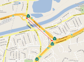
Route 55 Connector to Weir Canyon (~ ORA R9.252 to ~ ORA R14.46R)
In November 2010, the CTC approved amending the Corridor Mobility Improvement Account (CMIA) Program and the State Transportation Improvement Program (STIP) for the Route 91 Widening — Route 55 connector to Weir Canyon project (PPNO 4598A) in Orange County (~ ORA R9.252 to ~ ORA R14.46R) to advance the construction schedule from Fiscal Year (FY) 2011-12 to FY 2010-11 and to split out $2,498,000 of STIP Regional Improvement Program (RIP) to later landscaping work required for the project.
In June 2009, the CTC approved for future consideration of funding this project, which will add one general purpose lane on eastbound Route 91 between the Route 91/55 connector and east of Weir Canyon Road interchange, and on westbound Route 91 east of Weir Canyon Road interchange and Imperial Highway interchange. This project will also modify the westbound on-ramps at Lakeview Avenue interchange. The project is programmed in the Corridor Mobility Improvement Account and the 2008 State Transportation Improvement Program. The estimated project cost is $96 million, capital and support. Construction is estimated to begin in Fiscal Year 2010-11. The scope, as described for the preferred alternative, is consistent with the project scope set forth in the approved project baseline agreement.
In May 2010, the CTC approved relinquishment of right of way in the county of Orange, to the Orange County Flood Control District, a political entity governed by the Orange County Board of Supervisors, along Route 91 between Weir Canyon Road and Coal Canyon Road, consisting of collateral facilities.
In July 2011, it was reported that groundbreaking was
scheduled for the $84 million project that will add one general-purpose
lane for six miles in each direction between Route 55 and the Route 241.
Crews will widen the bridge for Imperial Highway and the Weir Canyon Road
undercrossing in both directions. Traffic estimates for 2011 are that this
section of Route 91 carries an average of up to 174,000 vehicles in the
eastbound direction with about 160,000 vehicles that travel the westbound
portion of that freeway. By 2014, officials expect that traffic volumes
will grow to an average of 158,000 to 190,000 daily. Funds for the
widening project come from the State Transportation Improvement Program
and Proposition 1B — a bond approved by voters in November 2006.
About $400,000 in funds are also provided by the renewed version of
Measure M that voters approved in 2006.
(Source: OC Register)
In August 2015, it was reported that there are indications that some of
the Route 91 improvements are working. Caltrans officials said the
completion of a widening project on Route 91 between Route 55 and Route 241 helped to reduce the delay experienced by all motorists from 5,169,147
hours a year in 2010 to 3,657,120 in 2011, or 29%. In 2012, preliminary
Caltrans figures show the amount of annual delay dropped an additional
12%. The latest available data from early 2014 shows, however, that the
amount of time wasted in traffic per year because of congestion is on the
rise. In the least, transportation officials say, the improvements have
kept up with the growth in traffic, and commute times have not increased.
(Source: LA Times, 8/4/2015)
Route 241 to Route 91 Connectors 12-ORA-91 (PM 14.7/18.9), and 08-RIV-91 (PM 0.0/1.5)
 In November 2016, it was noted that the Transportation Corridor Agencies (TCA), in coordination
with Caltrans, is proposing to add a direct connector linking the
northbound Route 241 Toll Road to the eastbound Route 91 Express Lanes and
the westbound Route 91 Express Lanes to the southbound Route 241 Toll
Road. The direct, median-to-median tolled connector would reduce traffic
congestion in both directions, enhance safety by reducing weaving across
lanes and improve access to toll lanes in Orange and Riverside Counties.
The 60-day public comment period for the Draft Supplemental Environmental
Impact Report/Environmental Impact Statement closed on January 9, 2017.
The Project Development Team is reviewing and evaluating all comments
received. Responses to these comments will be included in the Final
Environmental Impact Statement/Record of Decision (FEIS/ROD) in
approximately December 2017. (Note that as of March 2019, there were still
no updates on this project).
In November 2016, it was noted that the Transportation Corridor Agencies (TCA), in coordination
with Caltrans, is proposing to add a direct connector linking the
northbound Route 241 Toll Road to the eastbound Route 91 Express Lanes and
the westbound Route 91 Express Lanes to the southbound Route 241 Toll
Road. The direct, median-to-median tolled connector would reduce traffic
congestion in both directions, enhance safety by reducing weaving across
lanes and improve access to toll lanes in Orange and Riverside Counties.
The 60-day public comment period for the Draft Supplemental Environmental
Impact Report/Environmental Impact Statement closed on January 9, 2017.
The Project Development Team is reviewing and evaluating all comments
received. Responses to these comments will be included in the Final
Environmental Impact Statement/Record of Decision (FEIS/ROD) in
approximately December 2017. (Note that as of March 2019, there were still
no updates on this project).
(Source: District 12 Project Page)
According to the Draft SEIR, the Proposed Project,
located at the junction of Route 241 and Route 91 in the cities of
Anaheim, Yorba Linda, and Corona, and the counties of Orange and
Riverside, would provide improved access between Route 241 and Route 91,
and is proposed to be a tolled facility. The proposed median-to-median
connector project encompasses 12-ORA-241 (PM 36.1/39.1), 12-ORA-91 (PM
14.7/18.9), and 08-RIV-91 (PM 0.0/1.5) for a total length of approximately
8.7 miles (mi). The improvements for the connector include 5.9 mi in the
cities of Anaheim and Yorba Linda and unincorporated Orange County, from
south of Windy Ridge Wildlife Undercrossing on Route 241 to Coal Canyon
Undercrossing on Route 91. The remaining 2.8 mi of the Proposed Project
include signage improvements (advance signage) in the cities of Anaheim
(1.2 mi), Yorba Linda (0.1 mi), and Corona (1.5 mi) and unincorporated
Orange and Riverside counties, with exact placement of the signage pending
the Final Design process. The Proposed Project is mostly within existing
California Department of Transportation (Caltrans) right-of-way, with one
partial acquisition required adjacent to eastbound Route 91. Construction
access and staging areas would occur within existing Caltrans right-of-way
and the partial acquisition adjacent to eastbound Route 91 as noted above.
The objectives of the Proposed Project are to implement the buildout of
the Eastern Transportation Corridor (ETC), attain compatibility with the
Route 91 mainline and 91 Express Lanes configuration, improve
operations and traffic flow between the 91 Express Lanes and the
Route 241 general purpose connectors, help achieve the Regional Mobility
Plan goals of reducing emissions from transportation sources, and enhance
the efficiency of the tolled system, thereby reducing congestion on the
non-tolled system on Route 91. The Proposed Project is needed to provide a
direct connection between Route 241 and the 91 Express Lanes to
accommodate the buildout of the ETC as well as existing and future
transportation demand. The proposed median-to-median connector is a later
phase of the ETC project, previously approved in 1994. It was originally
evaluated as a Route 241/Route 91 highoccupancy vehicle (HOV) direct
connector in the 1991 ETC Draft Environmental Impact Report/Environmental
Impact Statement (Draft EIR/EIS), 1992 ETC Final EIR, and the 1994 ETC
Final EIS (all of which studied a broader Project Area with improvements
on Route 133, Route 241, and Route 261. There was only one build
alternative and the no-build alternative.
(Source: Draft SEIR for Rte 241/Rte 91 Connectors, Project Alternatives Chapter)
The Build Alternative would construct a two-lane express lane median-to-median connector between Route 241 and Route 91, which would connect lanes from the median of northbound Route 241 to the existing eastbound median 91 Express Lanes and the reverse movement from the westbound median 91 Express Lanes to the median of southbound Route 241. The connector would be tolled. The Build Alternative would merge into the existing Orange County Transportation Authority (OCTA) 91 Express Lanes at Coal Canyon Undercrossing. The Riverside County Transportation Commission’s (RCTC) Route 91 Corridor Improvement Project (CIP) will extend the express lanes on Route 91 east to I-15. The Build Alternative is compatible with the approved Route 91 CIP for both the initial and ultimate configurations, including the number and widths of the express lanes, express auxiliary lanes, and general purpose lanes.
In December 2017, it was reported that OCTA leaders
have pushed for a delay on any plans for a $180 million ramp linking the
Route 241 toll road and Route 91 Freeway Express Lanes (~ ORA R16.184)
over fears the project could increase congestion on both the freeway and
the tollway that runs along the middle of it. The 10-3 vote by the Orange
County Transportation Authority’s board requests that the
Transportation Corridor Agencies – the public agency that runs the
Route 241 toll road and is the driving force behind the proposed connector
– slow down on plans for an elaborate ramp connecting the paid
traffic lanes. Instead, the OCTA board directed its staffers to work with
the Riverside County Transportation Commission to come up with big-picture
proposals on how to improve the chronically congested traffic lanes on
Route 91. The vote follows a recommendation earlier this month by the
OCTA’s Executive Committee. It is unclear if the project could
proceed without the backing of the OCTA, which owns the 91 Express Lanes.
Rush-hour commuters coming from south and central Orange County going to
Riverside County who are willing to pay tolls to avoid as much congestion
as possible must choose: Take Route 241 and endure the Route 91 freeway,
because drivers can’t enter the Route 91 Express Lanes at that
point. Or endure traffic before reaching the Route 91 Express Lanes. It
takes a long leg in the middle to take both. The ramp would connect the
tollways in both directions, although public debate has focused on the
eastbound direction. The Transportation Corridor Agencies touts the Route 241/Express Lanes connector as key to decreasing congestion, creating more
efficient toll lanes and improving safety for drivers who would no longer
have to weave over multiple lanes of traffic to move between Route 241 and
91 Express Lanes at the county border. That is the first place motorists
coming from Orange County can exit the Express Lanes; they can enter it
there, too. OCTA’s staffers, however, disagree. They say the
connector would lure more motorists to the overall corridor, and create
more weaving at the Orange County/Riverside County line. Orange County
Supervisor Shawn Nelson questioned why if Caltrans thought the current
freeway setup was so dangerous its officials didn’t do something
about it when Route 241 was first built.
(Source: OC Register, 12/11/2017)
In December 2017, it was reported that Orange County
Transportation Authority staffers fearful of increased congestion on the
Route 91 freeway and the adjacent 91 Express Lanes want Route 241 toll road leaders to pump the brakes on plans for a $180 million ramp
linking Route 241 and the Express Lanes. Further, an executive
committee, comprised of seven OCTA board members, backed that opposition,
preferring that the Transportation Corridor Agencies, which manages Route 241, to defer any work on the planned connector. Leaders of the Riverside
County Transportation Commission have raised similar concerns about the
elaborate ramp increasing traffic and congestion. The project would create
a clear shot from Route 241, which runs between south and north Orange
County along its eastern side, to the 91 Express Lanes that roll
along the middle of Route 91 into Riverside County, bypassing typical
freeway traffic the entire route for those willing to pay tolls. Caltrans,
which serves as owner and operator of state freeways, has approved the
draft environmental plan for the connector, said Caltrans spokeswoman
Lindsey Hart. The agency is still analyzing traffic data and public
comments about the connector to “determine the potential traffic
benefits of the project,” she added. The TCA was hoping to complete
the final design of the connector in early 2018. If approved, construction
could begin in early 2019 and take about two years to complete.
(Source: Orange County Register, 12/17/2017)
In April 2019, it was noted that concerns about
the Route 241/Route 91 transition have prompted Transportation Corridor
Agencies (TCA) officials to add increased signage, and double white lines
in an attempt to deter drivers from cutting into the NB Route 241 to EB
Route 91 transition at the last minute. But even an increased number of
law enforcement officers issuing citations doesn't seem to be deterring
drivers from illegally cutting across the double white lines. TCA is also
considering both short-term and long-term fixes to this problem. One
option includes installing pylons, also called delineators or
channelizers, between the eastbound and westbound transition lanes. A
feasibility study is currently underway, but TCA would not give a time
frame on the project. Ultimately, the decision on whether to install
channelizers up to Caltrans. Caltrans is in discussions with TCA about the
potential use of delineators, centering around various items including who
will maintain them, what benefit they will add, and if they are safe to
place at this location. They want to ensure that the delineators are set
up in a way that those who are maintaining them can do so safely, as well
as understanding the impacts that delineators can have on weaving
(merging) vehicles, the study of current traffic patterns, and what types
of traffic management actions will be needed to maintain the delineators.
As noted above, the long-term fix is the dedicated connector. Construction
could begin in 2021, with completion in 2023.
(Source: ABC 7, 4/16/2019)
In May 2019, it was reported that Caltrans received a
23-page letter from Riverside County transportation officials about all
the things they think are wrong with plans for bridges that would let toll
road drivers bypass lanes of traffic to get between the Route 241 and
Route 91 freeways. The state agency and toll road officials say
they’re taking seriously those concerns – also shared by
Orange County’s transit agency – as they decide whether to
start designing the $180 million ramps, but “as of now we are moving
forward with the project,” Caltrans spokesman David Matza said.
Riverside and Orange county officials fear solving backups on the Route 241 toll road will make things worse on the Route 91 unless the fixes
they’re planning on the Riverside Freeway are done first. They also
question traffic study data they say is too old and inconsistent. The four
agencies appear set for a turf battle: on one side are Caltrans, which
owns the state highway system, and the Transportation Corridor Agencies,
which manage Orange County’s toll roads; on the other, the Riverside
and Orange county transit agencies, which have typically taken the lead on
long-term planning and funding for new local freeway projects. Everyone
agrees building a direct path between the Route 241 toll road and Route 91
express lanes ultimately would help clear backups and improve safety. Toll
road officials want to solve congestion near the Route 241 Windy Ridge
toll plaza, where northbound cars are funneled onto the eastbound Route 91. Using the existing medians, the proposed bridges would provide a
direct route into the 91 express lanes; in the other direction,
there’s currently no way to get from the westbound Route 91 express
lanes to southbound Route 241. Orange and Riverside county transit
officials want time to do three other projects intended to loosen choke
points between I-15 and the Orange County line: building another westbound
lane on Route 91 from Green River Road to Route 241; adding ramps to move
cars from the Route 91 express lanes to the I-15; and replacing a
hairpin-turn offramp from Route 91 east to Route 71 north with a flyover
ramp that wouldn’t slow traffic as much. If TCA’s new ramps
are built and opened first, they could dump hundreds more cars into the
Route 91 express lanes at peak drive times, forcing some drivers into
already crowded general purpose lanes, Orange County Transportation
Authority spokesman Joel Zlotnik said. (Drivers would pay an additional
toll to use the new bridges.) The timeline for at least one of the
projects on Route 91 remains uncertain. The added westbound lane and I-15
connector project could be done in 2022, but officials don’t yet
have funding for construction of the Route 71 interchange. Caltrans is
nearly done with the environmental analysis, after which design can begin.
A two-year construction schedule could wrap up in 2023.
(Source: OC Register (Paywall), 5/22/2019)
In November 2019, it was reported that OCTA approved an
agreement with the Riverside County Transportation Commission,
Transportation Corridor Agencies and Caltrans that lays the groundwork for
the construction of a tolled connector between the Route 241 Toll Road and
the Route 91 Express Lanes. The agreement is a result of several months of
discussions and sets the stage for traffic relief, while ensuring the
project smoothly integrates with others planned in Orange and Riverside
counties, including the Route 91 Express Lanes/I-15 Connector and the
Route 91 Corridor Operations Project. The proposed project would connect
the Route 241 Toll Road directly with the Route 91 Express Lanes, about 2
miles west of the Orange County border with Riverside County. Construction
of the connector is anticipated to begin in 2023.
(Source: OCTA Blog, 11/6/2019)
In May 2020, the CTC approved for future consideration
of funding a project for which a Final Supplemental Environmental Impact
Report (FSEIR) has been completed: Route 241 and Route 91 in Orange and
Riverside Counties. Construct a tolled facility between Route 241 and
Route 91 in Orange and Riverside Counties. (EA 0K9700) The project is
located in the cities of Anaheim, Yorba Linda, and Corona in Orange and
Riverside counties. The project proposes to improve access and reduce
congestion at the Route 241/Route 91 interchange by providing a direct
connector between Route 241 Toll Road and the
Route 91 Express Lanes. The estimated project cost is $182,298,000.
Construction is estimated to begin Fiscal Year 2022-2023. The Department,
the Orange County Transportation Authority, the Riverside County
Transportation Commission and the Toll Roads Corridor Agency support the
project.
(Source: May 2020 CTC Agenda, Agenda Item 2.2c.(8))
According to the FSEIR, the purpose of the Proposed
Project is to implement the build out of the Eastern Transportation
Corridor (ETC), for which the Final Environmental Impact
Report/Environmental Impact Statement was approved in 1994. The overall
objective of the ETC project was to accommodate traffic growth associated
with planned and approved development in Orange County. In addition to the
originally intended objectives of the ETC, changed circumstances at the
Route 241/Route 91 interchange have led to the following objectives for
the Proposed Project: implement the built out of the ETC, as approved in
1994; attain compatibility with the Route 91 mainline and Route 91 Express
Lanes; improve traffic flow and operations by reducing weaving across
multiple general purpose lanes between the Route 91 Express Lanes and the
Route 241 general lane connectors; and enhance the efficiency of the
tolled system, thereby reducing congestion on the non-tolled system on
Route 91. The need for the Proposed Project is to address roadway
deficiencies including: peak-hour demand exceeding capacity between the
Route 241 and Route 91 connectors, lack of connectivity between
tolled/managed facilities, and weaving between general purpose connectors
and median lanes reducing traffic flow. Caltrans, in cooperation with the
Foothill/Eastern Transportation Corridor Agency (F/ETCA), proposes to
construct a tolled direct connector between Route 241 and the Route 91
Express Lanes. Currently, there is no direct connection between the Route 241 toll road and the 91 Express Lanes.
(Source: May 2020 CTC Agenda, Agenda Item 2.2c.(8))
Route 241 (Orange County) to Route 71 (Riverside County)
Chino Hills Widening (~ ORA R16.184 to RIV R2.015)
In December 2005, the OCTA and the RCTC approved the addition of an extra eastbound lane, from the Foothill-Eastern tollway (Route 241) in Anaheim to the Corona Expressway (Route 71). Plans call for completion of that lane in two to three years. They also approved the planning phases of a widening project for one or two lanes in both directions between I-15 in Riverside County and Route 55 in Orange County. Board members also asked for more analysis on the possibility of adding four to six lanes elevated over the median or alongside Route 91 from I-15 to the Route 261. The agency eliminated from consideration plans to widen Route 55, into which Route 91 feeds, and to widen Ortega Highway (Route 74) in South County. Some of these items were submitted for funding from the 2007 Corridor Mobility Improvement Account (CMIA) allocations. The projects approved for funding on this route were the EB auxiliary lane, Route 241 to Route 71 ($71.4 million funded out of $73.8 million requested) and the addition of lanes from Route 55 to Gypsum Canyon ($22 million funded out of $48 milllion requested). However, there were two requests that were not recommended for funding: a WB auxiliary lane from Route 55 to Tustin ($47.5 million), and converting the WB auxiliary lanes to through lanes from Route 57 to I-5 ($36 million).
In January 2009, the CTC approved for future consideration of funding roadway improvements including widening of existing lanes and constructing an additional lane on Route 91 between Route 241 near Yorba Linda and Route 71 near Corona. Specifically, the project will construct roadway improvements to a 6.9 mile long section of Route 91 in Riverside and Orange Counties. The improvements will include widening of existing lanes and shoulders and the construction of an additional lane in both directions between Route 241 and Route 71. The project is programmed with corridor mobility improvement account funds, traffic congestion relief funds, local funds, federal demonstration funds, and Regional Measure 2 funds. The total estimated project cost is $81,400,000. The construction is estimated to begin in Fiscal Year 2009-10. The scope, as described for the preferred alternative, is consistent with the project scope set forth in the approved project baseline agreement. The rough routing is as follows:
![[241-71]](maps/091-241-71-widen.jpg) In November 2009, construction began on the $59.5-million project. The roughly 6-mile-long project will run from
Route 241 to Route 71, and will add one lane to the four existing
eastbound lanes, excluding two express lanes. In January 2010, the CTC
adjusted funding so that demonstration construction could start sooner
using design-build. The lane was opened to traffic in December 2010.
In November 2009, construction began on the $59.5-million project. The roughly 6-mile-long project will run from
Route 241 to Route 71, and will add one lane to the four existing
eastbound lanes, excluding two express lanes. In January 2010, the CTC
adjusted funding so that demonstration construction could start sooner
using design-build. The lane was opened to traffic in December 2010.
In June 2012, information was provided on the estimated
pricing for the Corona HOT lanes. The peak rush-hour toll for the
eastbound Corona stretch would be $5.45; through the Santa Ana Canyon in
Orange County, the highest price now is $9.75. The full, 18-mile stretch
could top $15 for a one-way trip on a Friday afternoon. Work on the lanes
is scheduled to begin in 2013. A firm will be chosen in early 2013 to
finalize designs and build the new lanes and other improvements. Once the
lanes are complete, transitioning between the toll lanes in Riverside
County and Orange County will appear seamless for drivers. The same in-car
transponders will track the tolls, and all the charges will be on the same
monthly bill. Drivers will be able to choose whether to take the toll
lanes in each county. For example, a driver could use them to bypass slow
traffic in Riverside County but hop into the general-use lanes in Orange
County. Similar to the Orange County setup, electronic message signs will
advertise the current price at toll-lane entry points. Unlike Orange
County, which raises prices only when traffic flow reaches a threshold of
3,128 cars per hour, Riverside County officials approved a tiered approach
that could result in more fluctuations in the hourly price, depending on
how busy the freeway is at those times.
(Source: Press-Enterprise, 6/11/12)
In March 2013, the CTC approved $39,173,000 in funding for construct of one mixed flow lane in each direction from Route 241 to Pierce Street (~ RIV 10.853), collector distributor system from Lincoln Avenue to I-15, one new HOT lane/convert existing HOV lane from County Line (Design-Build Project).
In December 2013, Riverside County broke ground on a long-anticipated widening project meant to smooth away a bottleneck that snags traffic at its border with Orange County. The project will widen each side of the freeway from four regular lanes to five and replace the single carpool lanes with dual pay-to-ride express lanes. Construction is scheduled to get underway in earnest by January and last until 2017.
The 2009 Economic Simulus funds were expected to speed up the construction of Route 91 between Route 241 and Route 71. OCTA staff members recommended that about $71 million of the expected stimulus money go toward Route 91 freeway project. An additional $4 million will come from toll revenue and state funding, and $5 million will come from the Riverside County Transportation Commission. Nearly 2,000 jobs would be created by Route 91 widening project. Construction is scheduled to begin in July 2009.
At its meeting on June 11, 2009, the CTC approved the request from the OCTA to delete the Route 91 Eastbound Lane — Route 241 to Route 71 Interchange project (PPNO 4678) in Orange County from the CMIA program. OCTA replaced $71,440,000 of CMIA funds with regional funds from the American Recovery and Reinvestment Act of 2009 (Recovery Act).
In February 2018, it was reported that RCTC officials
still feel that fixes are needed in the Route 91 corridor. An additional
westbound freeway lane, from Route 71 Freeway to Route 241, was one
solution presented in mid-February 2018 to the Riverside County
Transportation Commission. Corona Mayor Karen Spiegel and a few other
commission members cited that option as one worth exploring to deal with
back-ups on Route 91 and nearby city roads that have left some commuters
frustrated. Since the toll lanes opened in March 2017, they’ve been
used by 1.2 million vehicles — about 40 percent more than the agency
projected — a report to the commission states. That’s 37,893
vehicles on an average day. That figure has resulted in $22.1 million in
toll revenue — about $15.5 million more than the agency anticipated.
The project has reduced congestion during many times of the day on the
heavily-traveled corridor. However, there are some “hot spots”
at which motorists continue to face congestion, including the entrance to
the toll lanes on westbound Route 91, past McKinley Street, and the
northbound I-15 Freeway connector to westbound Route 91 entering the toll
lanes. One of the worst is westbound Route 91 from Route 71 going past
Green River Road and toward the Orange County line. During the morning
commute, 1,800 to 2,000 vehicles an hour are entering the westbound Route 91 from Route 71 and Green River. As a result, Green River — which
connects to Route 15 through the Foothill Parkway — has seen
vehicles backing up for a mile or two on weekday mornings, residents say.
The additional lane — which would be added by converting the
existing right-hand shoulder pavement — is one of six options for
the Green River corridor. Others included adding the lane for a shorter
distance, moving the toll lane entrance and exits further east, converting
the toll lane exit and entrance into a continuous weaving lane and turning
off the metering ramp at the Green River entrance. For northbound I-15,
the two proposed solutions were extending the toll lanes further south and
adding a second entrance to the toll lanes.
(Source:$$ Press-Enterprise, 2/14/2018)
In May 2018, it was reported that the Riverside County
Transportation Commission approved in a near-unanimous vote environmental
studies and design work for adding a general-purpose westbound lane on
Route 91, stretching from Green River Road (~ RIV R1.944) to Route 241 in
Orange County. The panel intends to reconvene in the fall to decide
whether to move forward with construction of the new lane, expected to
cost $30 million to $50 million and take two and a half years to build.
(Source:$$ Press Enterprise, 5/9/2018)
In December 2018, it was reported that the Riverside
County Transportation Commission approved adding a new westbound lane on
Route 91 stretching from Green River Road in Corona to the Route 241 toll
road in Orange County. The $42 million project will increase the number of
general-purpose lanes to six on the 2-mile-long westbound section of the
freeway. Environmental studies are underway. The panel, governed by
representatives from Riverside County and each county city, decided to
press forward to complete those studies, design the new lane and build it.
Construction could start in summer 2020 and be completed by fall 2021,
according to a report given at the meeting. Still to be determined is the
source of funding for the construction component — estimated at
$36.2 million. The lane will be built at a major choke point on the
crucial artery that connects Riverside County commuters with jobs in
Orange and Los Angeles counties. According to the commission, 312,000
vehicles travel Route 91 daily at the Riverside-Orange county line. The
lane is part of a package of improvements the panel endorsed in May with
the goal of improving traffic conditions through Corona. The commission
also lengthened by 1 mile a toll lane on northbound I-15 near Route 91 and
repainted lines to create a continuous express-lane entrance-exit lane at
the county line.
(Source: $$ Press Enterprise, 12/12/2018)
In April 2019, it was reported that the City of Corona
hoped to relieve pressure on two city streets that routinely clog in the
morning rush hour by making other routes to Route 91 more attractive to
regional commuters. The problem is that commuters routinely cut through
the city of 165,000 and transform Green River Road and Serfas Club Drive
into gridlock. The city wants those commuters to instead consider getting
back on the freeway at Main Street or Lincoln Avenue. Corona is working to
synchronize traffic signals on Main and Lincoln, and travel speeds have
improved on those north-south arteries. The new strategies are being
touted in the wake of widespread frustration in Corona about the traffic
nightmare that persists despite the 2017 completion of a $1.4 billion
makeover of Route 91 between I-15 and the Riverside-Orange county line.
The city also is rolling out other strategies to get cars moving on Green
River and Serfas Club, including installation of a new traffic signal
along Green River at Montana Ranch Road and plans to add another at the
Green River intersection with Tanglewood Drive. On Serfas Club
Drive, the city plans to add a second turn lane in each direction to let
commuters merge onto westbound Route 91 faster in the morning. The city
also wants the option of turning off ramp meters at the Green River
entrance to westbound Route 91 in the wake of a major accident that ties
up the freeway and side streets when the freeway recovers quicker and the
local streets are falling behind. But Caltrans is not likely to agree to
that.
(Source: $$ Press Enterprise, 4/18/2019)
In August 2020, it was reported that construction of a
new 2-mile, general-purpose westbound lane on Route 91 — from Green
River Road in Corona to Route 241 (toll) in eastern Orange County —
is set to begin in October 2020 and finish in 12 months. The work involves
laying down new pavement 9 to 10 feet wide and building retaining walls on
westbound Roue 91, as well as installing signs and lights, and rebuilding
Green River Road near the Green River Golf Club entrance. The lane will be
built along the north side of the freeway. The RCTC, which plans and funds
highway and rail improvements in Riverside County, is directing the $18.9
million project. Alas, relief delivered by freeway improvements in
Southern California tends to be short lived because of a phenomenon
transportation experts call induced demand. Generally what happens is when
capacity expands and speeds increase, drivers who formerly avoided a
highway hear of the improvement and drive on that road, causing speeds to
decrease.
(Source: $$ Press Enterprise, 8/24/2020)
Green River Interchange ⁃ Route 71/Route 91 Interchange (~ RIV R1.944)
![[TCRP 64]](maps/091-tcrp-64.jpg) There are currently plans (TCRP #64) to improve the Green River Interchange to NB Route 71, including adding an
auxiliary lane and connector ramp. (June 2002 CTC Agenda Item 2.1c.(1)).
In August 2007, the CTC approved two actions regarding this project,
specifically with Project #64.1 and #64.2. TCRP #64.1 would improve the
Green River Interchange and add an auxiliary lane and connector ramp east
of the Green River Interchange to northbound Route 71 in Riverside County.
Project #64.2 would improve the Green River Interchange and add an
auxiliary lane and connector ramp east of the Green River Interchange to
northbound Route 71 in Riverside County. The actions that were approved
were to transfer $590,000 in TCRP funding from TCRP #64.1 to TCRP #64.2
for Plans, Specifications, and Engineering (PS&E), to program
$4,410,000 in new TCRP funds for PS&E on #64.2, and to update
schedules. The overall project goal is to relieve congestion and improve
local traffic circulation on Route 91 in the area of Green River Road and
Route 71. TCRP Project #64.1 relieves congestion on Route 91 in the area
of Green River Road and Route 71 and improves local traffic circulation on
Green River Road in the vicinity of Route 91 by replacing the current
3-lane Green River Road overcrossing with a 6-lane overcrossing,
modification of ramps, and local street improvements at the interchange.
Project 64.1 was completed in 2007 with funds remaining in the account due
to various transfers. TCRP Project #64.2 relieves congestion on Route 91
in the eastbound direction by adding a lane in the vicinity of the Green
River Interchange on eastbound Route 91 between Route 241 and Route 71,
near the Riverside/Orange County line, extending to the Route 71/Route 91
interchange near the city of Corona in Riverside County. This project
should complete in FY11/12.
There are currently plans (TCRP #64) to improve the Green River Interchange to NB Route 71, including adding an
auxiliary lane and connector ramp. (June 2002 CTC Agenda Item 2.1c.(1)).
In August 2007, the CTC approved two actions regarding this project,
specifically with Project #64.1 and #64.2. TCRP #64.1 would improve the
Green River Interchange and add an auxiliary lane and connector ramp east
of the Green River Interchange to northbound Route 71 in Riverside County.
Project #64.2 would improve the Green River Interchange and add an
auxiliary lane and connector ramp east of the Green River Interchange to
northbound Route 71 in Riverside County. The actions that were approved
were to transfer $590,000 in TCRP funding from TCRP #64.1 to TCRP #64.2
for Plans, Specifications, and Engineering (PS&E), to program
$4,410,000 in new TCRP funds for PS&E on #64.2, and to update
schedules. The overall project goal is to relieve congestion and improve
local traffic circulation on Route 91 in the area of Green River Road and
Route 71. TCRP Project #64.1 relieves congestion on Route 91 in the area
of Green River Road and Route 71 and improves local traffic circulation on
Green River Road in the vicinity of Route 91 by replacing the current
3-lane Green River Road overcrossing with a 6-lane overcrossing,
modification of ramps, and local street improvements at the interchange.
Project 64.1 was completed in 2007 with funds remaining in the account due
to various transfers. TCRP Project #64.2 relieves congestion on Route 91
in the eastbound direction by adding a lane in the vicinity of the Green
River Interchange on eastbound Route 91 between Route 241 and Route 71,
near the Riverside/Orange County line, extending to the Route 71/Route 91
interchange near the city of Corona in Riverside County. This project
should complete in FY11/12.
In October 2011, the CTC approved for future consideration of funding a project to construct a direct flyover connector from eastbound Route 91 to northbound Route 71 and reconfigure the eastbound Route 91 ramp between Green River Road and the Route 91/Route 71 interchange. The project is not fully funded. The project is programmed in the 2010 State Transportation Improvement Program. The total estimated cost is $113,000,000 for capital and support. Construction is estimated tobegin in Fiscal Year 2015-16. The scope as described for the preferred alternative is consistent with the project scope programmed by the Commission in the 2010 State Transportation Improvement Program. A copy of the MND has been provided to Commission staff. Due to potential impacts to hazardous waste, visual resources, hydrology and water quality, noise, biological resources, and traffic, an Initial Study was completed for the project. Based upon environmental studies and proposed environmental commitments, including minimization and avoidance measures, restoration activities, and incorporation of BMPs, the project will not have a significant effect on the environment. As a result, an MND was completed for this project.
In April 2018, it was reported that the RCTC requested
state funds to cover most of the $117 million cost of the long awaited
Route 71/Route 91 interchange rework, and the California Transportation
Commission could approve the request in May. Riverside County officials
proposed putting up $23.4 million, or 20 percent of the price tag.
However, there’s one giant qualification: Even if the Riverside
County Transportation Commission manages to win a promise to fund the
project, the dollars would come from a pot of money generated by
California’s controversial raising of the gasoline tax increase last
year through SB1 and there is a movement under way to repeal the tax
increase. Parsons Transportation Group did an environmental analysis in
June 2011, then updated it in November 2014, a commission report states.
Because of the time that has elapsed, officials say the analysis needs to
be updated again. That effort received a $2 million boost earlier this
year from the state transportation agency. As for the project, the
centerpiece is a new sweeping, multi-lane flyover ramp that would connect
eastbound Route 91 with northbound Route 71. It would also reconfigure the
eastbound Route 91 ramp between Green River Road and the Route 71/Route 91, the report states. If the state commission funds the interchange, and
if the gas tax survives, construction could start in 2019 and take about
two years.
(Source: $$ Press Enterprise, 4/14/2018)
In November 2018, it was reported that a new westbound
Route 91 lane at the Riverside-Orange county line that would help relieve
severe congestion has been given the green light, but transportation
officials are abandoning the idea of turning off Green River Road ramp
meters. After sometimes confusing rush-hour experiments in June, September
and October, Caltrans has concluded that switching off the Green River
signals altogether — or allowing two cars to go with each green
signal instead of one — won’t help. Trial results were
presented at a Riverside County Transportation Commission subcommittee
meeting Monday, 11/26/2018. But the panel set the stage for construction
of the westbound general-purpose lane, which would extend from Green River
to the Route 241 toll road. David Thomas, the commission’s toll
project manager, said the lane could shave as many as 15 minutes on the
morning drive from I-15 to the Orange County line. The panel — the
Western Riverside County Programs and Projects Committee —
recommended moving forward with the westbound lane, and the full
commission is expected to approve those plans in December. Construction is
estimated to cost $36.2 million. Environmental studies are underway and
design is expected to be completed by the end of 2019, a report stated.
Construction would begin in 2020 and be completed by fall 2021. With
respect to the ramp meters, it was noted that the experiment with two cars
per green light was was carried out over three days — Oct. 1-3
— then discontinued. Sheldon Mar, a traffic consultant, said just 32
percent of motorists proceeded on green with another car on the first day
of the two-per-green trial. He said that rate increased to 62 percent the
second day and to 67 percent on the third. After the meeting, spokeswoman
Jocelyn Whitfield said Caltrans did not intend to do any more experiments.
The experiment did show that turning off ramp traffic signals slashed
delays driving west on Green River in the morning by 5 to 10 minutes;
however, delays on the mainline of Route 91 increased 1 to 3 minutes.
Further, once commuters realized Green River Road was moving more
efficiently, some abandoned the freeway, causing Green River delays to
increase. Overall, the change created more delay than it saved;
additionally, switching off the signals induced hundreds of commuters to
dangerously merge into Route 91 traffic well before the on-ramp meets
Route 91.
(Source:$$ Press Enterprise, 11/27/2018)
In November 2020, it was reported that the California
Transportation Commission staff recommended on 11/16/2020 to fund this
project and two others in Riverside County. The CTC will vote December 2
and 3, 2020 on the recommendations, which were made through a statewide
competitive grant process. A “yes” vote by the CTC would
allocate gas tax revenue from Senate Bill 1 to projects that include $58.1
million for the Route 71/Route 91 Interchange Project, Corona.
(Source: RCTC, 11/18/2020)
In March 2021, the CTC received notice of a proposed
amendment to the 2020 STIP to program an Assembly Bill (AB) 3090
reimbursement project (PPNO 0077M) in order to advance the construction of
the Route 91/Route 71 Interchange and Connectors project (PPNO 0077G) in
Riverside County with local funds (Measure A). It is proposed to schedule
the AB 3090 reimbursement over a three-year period beginning in Fiscal
Year 2022-23. The Route 91/71 Interchange and Connectors project (PPNO
0077G) will replace the eastbound Route 91 to northbound Route 71 loop
connector with a direct connector ramp. It will also realign the Green
River Road eastbound entrance ramp to Route 91 and construct a
collector/distributor system in the eastbound direction between the Green
River Road and Serfas Club Drive. Currently, $66,377,000 in Regional
Improvement Program funding is programmed in 2022-23 to the construction
(CON) phase of the project. On December 2, 2020, the Commission
approved programming of $58,108,000 of Senate Bill 1 Trade Corridor
Enhancement Program funds in 2021-22 for CON phase, per Resolution
G-20-77, to the Route 91/Route 71 Interchange and Connectors project. RCTC
anticipates this project being ready to list in December 2021 with
contract award shortly thereafter. However, the STIP funds for this
project are programmed in 2022-23 and cannot be allocated in advance due
to capacity constraints in the 2020 STIP. As such, RCTC proposes to fund
the construction component with local funds (Measure A) in order to
accelerate delivery in 2021-22. The amendment was approved by the
CTC in June 2021.
(Source: March 2021 CTC Agenda, Agenda Item
2.1b.(3); June 2021 CTC Agenda, Agenda Item 2.1a.(20))
In July 2021, it was reported that improving the
heavily congested and operationally deficient Route 71/Route 91
Interchange in Corona took another step forward with the Riverside County
Transportation Commission’s award of a construction management
contract to Corona-based Falcon Engineering. The interchange serves as a
gateway between Riverside, Orange, and San Bernardino counties and is a
vital link for commuters and freight vehicles that use the Route 91. The
interchange reconstruction project is designed to help relieve traffic
congestion, increase travel reliability, improve safety, and enhance air
quality. Project team members are finalizing environmental approvals,
plans, and permits before advertising for construction bids in Spring
2022. Construction is expected to start during the second half of 2022 and
take about three years to complete.
(Source: RCTC, 7/7/2021)
In August 2021, the CTC revised the June 2021 amendment
to the STIP: Revise: Route 71/Route 91 interchange EB-NB Connector project
(PPNO 0077G, EA 0F541). 08-RIV-091 R0.900/R2.600. Route 91 Near the City
of Corona in Riverside County. Replace eastbound Route 91 to northbound
Route 71 loop connector with a direct connector ramp. Realign the Green
River Road eastbound entrance ramp to Route 91and construct a
collector/distributor system on Route 91 in the eastbound direction
between the Green River Road and Serfas Club Drive. Updated financials ($
× 1,000): Const Cap: $135,615 ⇒ $145,684; Total $164,844
⇒ $174,913.
(Source: August 2021 CTC Agenda, Agenda Item
2.1a.(2))
In March 2022, the CTC approved a request of
$68,177,000 for the locally-administered multi-funded TCEP/STIP Route 71/Route 91 Interchange EB-NB Connector project (08-Riv-091 R0.9/R2.6;
08-Riv-071 1.9/3.0), on the State Highway System, in Riverside County,
programmed in FY 2022-23. (PPNO 08-0077G; ProjID 0800000137; EA 0F541).
Replace eastbound Route 91 to northbound Route 71 loop connector with a
direct connector ramp. Realign the Green River Road eastbound entrance
ramp to Route 91, and construct a collector/distributor system on Route 91
in the eastbound direction between the Green River Road and Serfas Club
Drive.
(Source: March 2022 CTC Agenda, Agenda Item
2.5s.(5) / 2.5v.(4))
 In January 2023, the CTC approved for future
consideration of funding the following project for which a MND and
Addendum have been completed: 08-Riv-71, PM 1.6/3.0, 08-Riv-91, PM
R0.6/R2.6. State Route 91/State Route 71 Interchange Improvement
Project. Route 71 and Route 91 in Riverside County. Replace
eastbound Route 91 to northbound Route 71 loop connector with a direct
connector ramp. Realign the Green River Road eastbound entrance ramp to
Route 91 and construct a collector/distributor system on Route 91, in the
eastbound direction between Green River Road and Serfas Club Drive, in
Riverside County. (PPNO 0077G) This project is located in Riverside
County. The project will construct a direct flyover connector from
eastbound Route 91 to northbound Route 71 and reconfigure the eastbound
Route 91 ramp between Green River Road and the Route 91/Route 71
interchange. The project is programmed in the 2020 STIP. The total cost is
$174,913,000, which includes SB 1 TCEP funding in Construction (capital).
Construction is estimated to begin in 2022-23. The scope as described for
the preferred alternative is consistent with the project scope programmed
by the Commission in the 2020 STIP. A MND was prepared because of
potential biological resource impacts. A copy of the MND has been provided
to Commission staff. The Commission approved the project for future
consideration of funding on October 27, 2011, under Resolution E-11-74.
Changes to the scope include Right-of-Way and easement modifications,
additional rock slope protection, culvert modifications, the addition of
two sound walls, and grading modifications. The Department subsequently
completed an Addendum to the MND pursuant to the California Environmental
Quality Act. The Department has approved this project for construction.
This approval and the Addendum will satisfy the environmental requirements
for this stage of the planning process.
In January 2023, the CTC approved for future
consideration of funding the following project for which a MND and
Addendum have been completed: 08-Riv-71, PM 1.6/3.0, 08-Riv-91, PM
R0.6/R2.6. State Route 91/State Route 71 Interchange Improvement
Project. Route 71 and Route 91 in Riverside County. Replace
eastbound Route 91 to northbound Route 71 loop connector with a direct
connector ramp. Realign the Green River Road eastbound entrance ramp to
Route 91 and construct a collector/distributor system on Route 91, in the
eastbound direction between Green River Road and Serfas Club Drive, in
Riverside County. (PPNO 0077G) This project is located in Riverside
County. The project will construct a direct flyover connector from
eastbound Route 91 to northbound Route 71 and reconfigure the eastbound
Route 91 ramp between Green River Road and the Route 91/Route 71
interchange. The project is programmed in the 2020 STIP. The total cost is
$174,913,000, which includes SB 1 TCEP funding in Construction (capital).
Construction is estimated to begin in 2022-23. The scope as described for
the preferred alternative is consistent with the project scope programmed
by the Commission in the 2020 STIP. A MND was prepared because of
potential biological resource impacts. A copy of the MND has been provided
to Commission staff. The Commission approved the project for future
consideration of funding on October 27, 2011, under Resolution E-11-74.
Changes to the scope include Right-of-Way and easement modifications,
additional rock slope protection, culvert modifications, the addition of
two sound walls, and grading modifications. The Department subsequently
completed an Addendum to the MND pursuant to the California Environmental
Quality Act. The Department has approved this project for construction.
This approval and the Addendum will satisfy the environmental requirements
for this stage of the planning process.
(Source: January 2023 CTC Agenda, Agenda Item 2.2c.(5))
Also in January 2023, the CTC approved an amendment for
the locally administered multi-funded SB 1 TCEP/STIP Route 71/Route 91
Interchange EB-NB Connector project (PPNO 0077G), on the State Highway
System, in Riverside County, to allow non-proportional spending for the
construction phase. The Commission allocated an advancement of $68,177,000
in March 2022, to the Riverside County Transportation Commission (RCTC)
for the locally-administered multi-fund SB 1 TCEP/STIP Route 71/Route 91
Interchange EB-NB Connector project for Construction phase. At that time,
the allocation approval the implementing agency, RCTC, did not request
non-proportional spending. Because of this, RCTC is now requesting
non‐proportional spending to fully exhaust the Federal earmarks
during the early stages of project delivery to maximize the use of Federal
funds. Otherwise, critical funding would be lost, and a local contribution
would be required. As such, RCTC requires non‐proportional spending
to meet the funding targets above.
(Source: January 2023 CTC Agenda, Agenda Item 2.5s.(8))
In May 2023, the CTC approved the following allocation
for a locally-administered STIP project: $19,913,000. 08-Riv-91 R0.9/R2.6;
08-Riv-71 1.9/3.0. PPNO 08-0077M; ProjID 0823000023 0800000137;
EA 1N121 0F541. AB 3090 Reimbursement - Route 71/Route 91 Interchange EB-NB Connector. Replace eastbound Route 91 to
northbound Route 71 loop connector with a direct connector ramp. Realign
the Green River Road eastbound entrance ramp to Route 91, and construct a
collector/distributor system on Route 91 in the eastbound direction
between the Green River Road and Serfas Club Drive. CEQA - CE, 10/12/2021
NEPA - CE, 10/12/2021. Right of Way Certification: 02/04/2022. Future
consideration of funding approved under Resolution E-11-74; October 2021.
Allocation: CONST $19,913,000.
(Source: May 2023 CTC Agenda, Agenda Item 2.5c.(8))
In October 2023, the CTC approved the following
locally-administered STIP AB 3090 Reimbursement project allocation:
$33,189,000. 08-Riv-91 R0.9/R2.6; 08-Riv-71 1.9/3.0. PPNO 08-0077M; ProjID
0800000137; EA 0F541. AB 3090 Reimbursement. Replace eastbound
Route 91 to northbound Route 71 loop connector with a direct connector
ramp. Realign the Green River Road eastbound entrance ramp to Route 91,
and construct a collector/distributor system on Route 91 in the eastbound
direction between the Green River Road and Serfas Club Drive. CEQA - MND,
06/29/2011; Re-validation 10/12/2021. NEPA - CE, 06/29/2011; Re-validation
10/12/2021. Right of Way Certification: 02/04/2022. Future consideration
of funding approved under Resolution E-11-74: October 2021. Contribution
from other sources: $0. Reimbursement as AB 3090 approved under STIP
Amendment 20S-08, June 2021. Allocation: CONST $33,189,000.
(Source: October 2023 CTC Agenda, Agenda Item 2.5c.(4))
The agency also agreed to continue studying controversial proposals for elevated lanes down the median of the existing highway, or alongside it, and a tunnel between Orange and Riverside counties through the Santa Ana Mountains (see Orange-Riverside County Connector below for more details).
In March 2020, the CTC approved the 2020 STIP, which continued the
programmed funding for PPNO 0071E "B Canyon Wildlife Crossing Corridor
(14S-04)". This project is in Western RIV, about 0.4 mi E of the RIV/ORA
county line, about 1.8 mi SW of Prado Dam, and 0.7 mi W of Green River
Road.
(Source: March 2020 CTC Agenda, Item 4.7, 2020 STIP
Adopted 3/25/2020)
In June 2017, it was reported that a 41-year-old mural in Corona's Prado
Dam, near the intersection of Route 71 and Route 91, that residents
throughout the area want to see preserved but could be dismantled by the
U.S. Army Corps of Engineers does not qualify as a historic landmark.
Spokesman Greg Fuderer said that following a months-long analysis, the
Corps' Los Angeles District staff determined that the beloved spillway
display does not meet the criteria for listing on the National Register of
Historic Places. The preliminary finding is slated to be finalized by July
10. The Corps specifically looked at whether the mural could be eligible
for recognition as a national treasure using the "exceptional
significance" standard, but found no validation, including lack of
"distinctive characteristics of a type, period or method of construction"
and no "information to contribute to our understanding of human history."
The Corps acknowledged "the importance of the mural to the local
community," but did not believe that served to justify preserving it,
Fuderer said. The cities of Corona, Eastvale and Norco have all passed
resolutions urging restoration and preservation of the mural. Riverside
County Board of Supervisors Chairman John Tavaglione has also expressed
support. The display, situated inside the flood control channel for the
Santa Ana River, was painted in May 1976 to celebrate America's 200th
birthday. More than 30 Corona High School students spent several weekends
voluntarily working on the project.
(Source: Lake Elsinore Patch, 6/7/2017. See also Friends of the Prado Dam Mural)
In January 2014, the CTC authorized relinquishment of right of way in the county of Orange, to the Orange County Flood Control District, a political entity governed by the Orange County Board of Supervisors, along Route 91 between the boundary common to Orange and Riverside Counties, and 0.7 miles westerly thereof, consisting of collateral facilities. The Orange County Flood Control District, by resolution dated February 9, 2010, waived the 90-day notice requirement and agreed to accept title upon relinquishment by the State.
Riverside County — Route 71 to I-15
Route 91 Corridor Improvement Project (~ RIV R1.944 to RIV 10.804)
Note: This portion of the discussion focuses on the Riverside County portion of the work, as it tend to be discussed differently being a different Caltrans District. See above for the Orange County portion of the discussion and the immediate area near the county board (to about Green River)
According to the Orange County Register, there are also plans to extend the Route 91 Express Lanes in a 12-mile stretch of Route 91 between Route 241 and Pierce Street in the city of Riverside. The preferred plan calls for the extension of Route 91 toll lanes, creating four toll lanes — two eastbound and two westbound — between the Riverside County line and Pierce, which is about three miles east of I-15. It also would add a general-purpose lane on each side of Route 91 and would create entries to Route 91 toll lanes from I-15 at Hidden Valley Parkway to the north and Cajalco Road to the south. The 12-mile stretch of Route 91 is traveled by an estimated 280,000 to 300,000 motorists each day. By 2030, that number is expected to skyrocket to some 425,000 motorists. Extending the toll lanes along the full 12-mile stretch and adding connectors from I-15 is estimated to cost $1.3 billion. About $300 million would come from Riverside County's Measure A, a half-cent sales tax for transportation projects in that county. The bulk of the remaining cost — some $1 billion — would come from the sale of private bonds, to be repaid by funds collected from motorists using the new toll lanes. Transportation officials hope to follow a design-build model — similar to the concept that allowed for the quicker expansion of Route 22; this would permit much of the improvements to be finished by the end of 2015.
In December 2009, the CTC received information on a proposal to amend the 2008 State Transportation Improvement Program (STIP) to reprogram $2,000,000 Regional Improvement Program (RIP) funds from the Route 91/Route 71 Interchange and Connectors project (PPNO 0077G) to a new Route 91 Corridor Improvement project (PPNO 0077J) in Riverside County. The Corridor Improvement project will reduce congestion and improve mobility within the corridor limits by constructing: one mixed-flow lane, in each direction, from Route 241 to Pierce Street, a collector/distributor system from Lincoln Avenue to I-15, a high occupancy toll (HOT) lane and/or conversion of one existing high occupancy vehicle (HOV) lane, in each direction, from the County Line to I-15, and a HOT median direct connector at the Route 91/I-15 interchange.
In October 2010, AB 2098 was signed, which allows the Riverside County Transportation Commission to utilize the “design-build” process for the 91 Corridor Improvement Project. Design-build permits the lead agency on a publicly funded project to keep procurement and contractor hiring under one roof, in contrast to “design-bid-build,” which requires dividing up the design and construction phases of a project between different entities. Design-build can shave three to five years off the time it takes to complete a project. It was estimated that 18,000 jobs would be created by the $1.3 billion project, which is slated to get under way in early 2012 and reach completion by late 2015. The project calls for an eight-mile extension of the two eastbound toll lanes that currently stop at the Riverside-Orange County line. Improvements will also be made to the I-15/Route 91 interchange in Corona and various roads that parallel Route 91.
The RCTC is preparing to launch construction of the makeover of Route 91 by late 2013 or early 2014. That massive undertaking, besides constructing toll lanes, entails adding two general-purpose lanes, replacing overpasses and building a sweeping connecting ramp that will drop northbound I-15 commuters into the new Route 91 express lanes. There are also plans for HOT lanes on I-15 once the Route 91 construction is complete.
In July 2011, it was reported that the $1.3 billion project to widen Route 91 through Corona and add two toll lanes in each direction must wait to receive a federal grant that transportation officials say is necessary to start the work. Specifically, the project could not proceed without the $446 million federal loan, and said loan was not in the Summer 2011 route of federal loan commitments for road and transit projects. If officials must wait to reapply for the $446 million loan until 2012, it would potentially delay the start of construction of the lanes until 2013, thereby moving the opening from 2017 to 2018.
In December 2011, the US Department of Transportation approved $20 million in TIGER funding for the Route 91 corridor. This payment will support a TIFIA loan that will finance up to one-third of the costs of the $1.3 billion, 8-mile extension of the Route 91 Express Lanes. The project will extend the Route 91 Express Lanes from the current eastern terminus at the border of Orange and Riverside Counties eastward to I-15. Additionally, one general-purpose lane will be added to the facility in each direction along the project route.
In October 2012, the CTC approved for future consideration of funding a project that will widen the Route 91 Corridor, including constructing one mixed-flow lane in each direction, one auxiliary lane in each direction, highoccupancy or tolled express lanes, and direct high-occupancy or tolled express lane connections between Route 91 and I-15. The project is programmed in the 2012 State Transportation Improvement Program. This project is included in the Design-Build pilot program. The total estimated cost for capital and support is $1,300,517,000. Construction is estimated to begin in Fiscal Year 2012-13. The scope, as described for the preferred alternative, is consistent with the project scope programmed in the 2012 State Transportation Improvement Program.
In March 2013, it was reported that the Budget and Implementation Committee for the RCTC approved a multi-million-dollar financing plan that calls for the issuance and sale of up to $475 million in Riverside County Transportation Commission sales tax revenue bonds (limited tax bonds), and up to $275 million in county transportation commission toll revenue bonds. The plan also includes a $435 million Transportation Infrastructure Finance and Innovation Act (TIFIA) loan from the U.S. Department of Transportation. These funds will be used to make improvements along Route 91 from the Orange County line to about Pierce Street in Riverside, including upgrading the interchange with I-15. The work would complement ongoing I-215 construction that includes widening as well as improvements to the Route 60/I-215 interchange
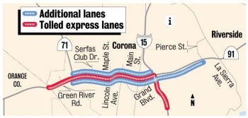 In May 2013, it was reported that the Riverside County Transportation
Commission on Tuesday, May 8, 2013, approved a $632.6 million contract to
widen Route 91, including the toll lanes, through Corona. The contract is
a major element of the $1.3 billion Route 91 Corridor Improvement Project.
The $1.3 billion figure includes the new contract and other money spent
acquiring land, designing the project and doing an environmental study.
Construction is scheduled to begin in early 2014. Preliminary work could
start this year and the lanes are expected to open by 2017. The project
will replace carpool lanes with two toll lanes in each direction that will
connect to toll lanes already in Orange County. Also, a fifth convention
lane will be added in each direction. Without the toll lanes, 22 regular
lanes would be needed to manage rush-hour congestion. Besides adding
lanes, the project will rebuild seven interchanges and provide a connector
from northbound I-15 to the Route 91 toll lanes. Street improvements in
Corona and additional express bus service also are part of the project.
In May 2013, it was reported that the Riverside County Transportation
Commission on Tuesday, May 8, 2013, approved a $632.6 million contract to
widen Route 91, including the toll lanes, through Corona. The contract is
a major element of the $1.3 billion Route 91 Corridor Improvement Project.
The $1.3 billion figure includes the new contract and other money spent
acquiring land, designing the project and doing an environmental study.
Construction is scheduled to begin in early 2014. Preliminary work could
start this year and the lanes are expected to open by 2017. The project
will replace carpool lanes with two toll lanes in each direction that will
connect to toll lanes already in Orange County. Also, a fifth convention
lane will be added in each direction. Without the toll lanes, 22 regular
lanes would be needed to manage rush-hour congestion. Besides adding
lanes, the project will rebuild seven interchanges and provide a connector
from northbound I-15 to the Route 91 toll lanes. Street improvements in
Corona and additional express bus service also are part of the project.
(Source: Press Enterprise, 5/8/13)
In July 2013, it was reported that the Riverside County Transportation Commission has announced the sale of bonds to pay for the construction, operation, and maintenance of the project. The funding ensures that work on the highway widening and new toll lanes in Corona will begin by the end of the year, even as land acquisition along the highway continues. Completion is set for 2017. The project will add at least two lanes of capacity to Route 91 at its most congested points through Corona. Toll lanes will be connected in a way that will take commuters traveling north on I-15 directly to the toll lanes. In addition, funding will rebuild seven interchanges and improve access from local streets to on- and offramps.
In October 2015, nine construction workers were
injured, three critically, after an on-ramp bridge that is being
constructed along Route 91 in Corona partially collapsed. The partial
collapse occurred about 11 p.m. as workers were lowering the bridge into
place at East Grand Boulevard, according to a news release from the
Riverside County Transportation Commission. The jacking operation failed,
which led to the bridge deck dropping more than a foot before it hit the
wooden support beams. Those beams subsequently struck the workers, causing
their injuries, the release stated. The construction was part of the 91
Project, which is adding regular and tolled express lanes, as well as
auxiliary lanes and direct express lane connectors between Route 91 and
I-15. Subsequent to the collapse, the determination was made to demolish
and reconstruct the damaged off-ramp amid concerns about the structural
integrity of the 750-ton bridge that spans East Grand Boulevard in Corona.
It was also noted that engineering reports revealed deficiencies prior to
the collapse, such as deficiencies in the bridge’s temporary
supports that were noted by an assistant county engineer the day before
the collapse. Those issues – among the many elements being
investigated by CalOSHA, Caltrans and Washington, D.C.-based KCE
Structural Engineers, which was hired by project contractor Atkinson Walsh
– were reportedly corrected prior to the faulty lowering,
engineering reports show. Water dripping from a light fixture on the
underside of the bridge, which was also noted by an assistant engineer the
day before the bridge was lowered, was placed on a list “to be
addressed later.” The day after the collapse, Atkinson Walsh
employees punched through the vent holes of the bridge and released 12 to
25 tons of water from the bridge, engineering reports show. The new
bridge, which will be paid for by Atkinson Walsh, will not be built using
the lowering process.
(Source: KTLA, 10/10/2015; Press-Enterprise 10/28/2015)
In December 2015, it was reported that ramps connecting
Grand Boulevard to Route 91 in Corona will be permanently closed in
December 2015. Drivers will be diverted to alternate ramps currently
undergoing improvements as part of the Route 91 expansion project. The
eastbound Grand Boulevard off-ramp is expected to close on Dec. 2, with
the westbound on-ramp to follow on Dec. 14.
(Source: Press Enterprise, 12/17/2015)
February 2016 saw Coronagate, a 55-hour
closure of Route 91 through Corona. This closure allowed crews to complete
three major facets of a $1.4 billion highway expansion at once –
instead of doing piecemeal work over the next three months. Crews
completed three major projects:tearing down the west side of Maple Street
bridge, erecting a frame to support construction of a flyover ramp from
Maple to WB Route 91 and paving nearly a mile of three EB Route 91 lanes
near I-15. The steel beams installed across Route 91 were the largest
portion of the flyover bridge project, but wooden framework is also
required to enable concrete pouring.
(Source: OC Register, 2/23/2016)
In September 2016, there was an update on the ongoing
$1.4 billion project to widen Route 91 from the Riverside County line in
Corona to Pierce Street just past I-15 interchange in Riverside. Headed by
the Riverside Transportation Commission, the project will add one regular
lane and two express toll lanes in each direction, including the building
of 11 new bridges, widening of 21 existing bridges, improving six
interchanges, building 95 retaining walls and erecting 287,000 sq. ft.
(26,663 sq m) of sound walls. The construction cost for the bridges alone
is between $160 million and $175 million. Work began in 2014 and is
expected to be complete in 2017. The project includes extensive use of
pile driving, the common method of using large hydraulic hammers to
construct foundations to support the bridges. Current construction also
includes drainage and wet utility installations, retaining wall
installation, bridge construction, concrete and asphalt paving, city
street improvements and infrastructure installation for toll operations.
Workers will apply 210,000 cu. yds. (160,556.5 cu ) of paving, add 90,000
linear ft. (27.4 m) of new drainage and relocate 92 full utility systems.
Crews also will use large amounts of steel beams and lumber for the false
work and formwork. Concrete and rebar will be used in the bridge
structure. Funding for the project is provided by a combination of
federal, state and local sources as well as toll revenue bonds. The
express lanes will be fully funded by tolls from drivers who choose to use
the lanes. Toll revenue will be used to repay the federal loan. The
project is divided into 10 segments along Route 91 and south on I-15. The
segments make it easier to report what work is currently taking place. The
Riverside County Transportation Commission purchased about 200 full or
partial properties for project right-of-way needs. The project has about
35 subcontractors including All American Asphalt of San Fernando, Calif.,
for asphalt paving; Drill Tech Drilling and Shoring of Antioch, Calif.,
for foundation drilling and shoring; Tipco Engineering of Bellflower,
Calif., for driven steel piles; Martinez Steel of Fontana, Calif., for
reinforcing steel fabrication and installation; Select Electric of
Norwalk, Calif., for electrical, communications and toll infrastructure;
SSL LLC of Scotts Valley, Calif., for mechanically-stabilized earth walls;
and EECOM of Los Angeles for design and engineering.
(Source: Construction Equipment Guide, 8/31/2016)
In March 2017, it was reported that after three years
of closures and construction, commuters on Route 91 in Corona will finally
see some relief. The new toll lanes and general lanes are opening Monday,
March 20, 2017. The $1.4 billion project on one of the region’s most
congested freeways has added two toll lanes and one general-use lane in
each direction on an 8-mile stretch from I-15 west to the Orange County
line. The milestone represents the culmination of a decade of work on the
biggest project the agency has ever handled. Crews also built or widened
32 bridges, improved five interchanges and realigned and repaved local
streets.
(Source: Press-Enterprise, 3/12/2017)
In June 2018, it was reported that this project was
honored in the 11th annual America’s Transportation Awards.
Sponsored by AASHTO, Socrata, AAA and the U.S. Chamber of Commerce, the
11th annual America’s Transportation Awards competition recognizes
transportation projects in three categories: Quality of Life/Community
Development, Best Use of Technology and Innovation and Operations
Excellence. California DOT (Caltrans) won in the large category (projects
costing more than $200 million) for its Route 91 Corridor Improvement
project, and in the Best Use of Technology and Innovation category for
Caltrans' Route 1/Pfeiffer Canyon Bridge Replacement. Caltrans also won
and award in the medium Operations Excellence category for the Route 191
Realignment Project: Taming the Curves.
(Source: For Construction Pros, 6/13/2018)
In November 2018, it was reported that new toll lanes
on Route 91 in Corona took in nearly $48 million — three times as
much as expected — in their first full year and are on pace to
generate $50 million this fiscal year. The rosier-than-anticipated
results, detailed in a report to a regional transportation panel, spurred
cries that tolls are too high and calls for spending surplus revenue on
improvements to the mainline Route 91 that could ease congestion.
Riverside County Supervisor Kevin Jeffries, who sits on the Riverside
County Transportation Commission’s panel, said the extra money
collected “beyond our wildest dreams” should be put to good
use. “To the extent that we can do so, we should reinvest those toll
revenues right back into the corridor to make the necessary improvements
to make the corridor flow better.” While it is true revenue exceeds
expectations, and the Riverside Transportation Commission staff welcomes
the idea of spending surplus money on improvements, the agency has
significant expenses associated with operating the toll lanes and paying
off a federal loan and toll bonds. Those expenses total $40.3 million for
the current fiscal year. Costs are expected to reach $47.8 million in
fiscal year 2021-22. The commission could use surplus dollars to fund a
new flyover connection between Route 71 and Route 91, expanded Metrolink
commuter train service in the Route 91 corridor and a new westbound lane
between Green River Road and Route 241. But half of surplus money
allocated for such projects — except for the 71-91 and another
project — must be used to pay down the federal loan.
(Source: Press Enterprise, 11/29/2018)
In March 2020, the CTC approved the 2020 STIP, which
transferred and increased programmed funding from PPNO 3009Y "AB 3090
Replacement Project (18S-15)" ($50,000K) on I-15 to PPNO 0077G "Rt 91/71
interchange and connectors (SB1)" ($66,377K).
(Source: March 2020 CTC Agenda, Item 4.7, 2020 STIP
Adopted 3/25/2020)
Riverside County — I-15 to Riverside
High Occupancy Toll Lanes - Corona/I-15 to Route 60/I-215
In July 2019, it was reported that the RCTC is
considering an ambitious plan for additional HOT lanes in the county:
(Source: $$ Press Enterprise, 7/6/2019)
In September 2019, it was reported that Riverside
County supervisors have formally declared their opposition to a proposal
to install express toll lanes on the Riverside (Route 91) Freeway between
Corona and the Route 60/Route 91/I-215 interchange, based mainly on lack
of justification for the lanes. The 4-0 vote by the Board of Supervisors,
with Supervisor Chuck Washington absent, conveys the county's official
position to the independent RCTC's action on July 10 to initiate a study
of the feasibility of placing toll lanes on both the east- and westbound
sides of Route 91 between I-15 and the Route 60/Route 91/I-215. The new
toll lanes, stretching 14 miles, would span the entire east- west length
of the city of Riverside, whose council members last month declared
opposition to the proposal in a 6-1 vote. RCTC officials have stated
publicly that the concept is in the nascent development stage and may
never move forward, though the feasibility study will continue. Staff have
cited the need for congestion relief on Route 91 as a driving factor.
Early estimates put the cost of constructing the toll lanes at $1 billion.
The County was particularly opposed to the RCTC concept that existing
carpool lanes on the east- and westbound sides of Route 91 would be
converted to minimum three-occupancy carry, instead of two per vehicle,
which would require carpoolers with only two to a car to pay fees. That
could push more commuters into standard lanes, adding to congestion,
instead of lessening it. An additional lane would be constructed on both
sides of the freeway solely for tolled express travel, regardless of the
number of individuals in the vehicle. Note that even if RCTC decides to
back away from the proposal, Caltrans, which is conducting a study of its
own, may opt to pursue it.
(Source: Lake Elsinore Patch, 9/10/2019)
Continuous Access HOV Lane Conversion (08-Riv-91 7.4/16.9)
In October 2016, the CTC amended the SHOPP as follows: 08-Riv-91 7.4/15.6 | Route 91In the cities from Corona and Riverside, from Route 15/Route 91 separator to Adams street overcrossing. Convert existing limited access HOV lanes to continuous access HOV lanes to allow safer ingress and egress movements for HOV. Project Split. FY 18/19.
In May 2018, the CTC amended this project in the 2018
SHOPP: 08-Riv-91 7.4/15.6 7.4/16.9 PPNO 3005X. On
Route 91: In the cities from Corona and Riverside, from Route 15/Route 91
separator to Adams Street overcrossing 0.3 mile east of
Madison Street Undercrossing. Convert existing limited access HOV
lanes to continuous access HOV lanes to allow safer ingress and egress
movements for HOV.
(Source: CTC Agenda, May 2018 Agenda Item 2.1a(2))
In January 2019, the CTC approved the following
allocation: $550,000 Riverside 08-Riv-91 7.4/16.9. Route 91 In the cities
of Corona and Riverside, from Route 15 to 0.3 mile east of Madison Street.
Outcome/Output: Convert existing limited access High Occupancy
Vehicle (HOV) lanes to continuous access HOV lanes to allow safer ingress
and egress movements for HOV. This project will reduce congestion and
improve safety.
(Source: January 2019 CTC Minutes, Agenda Item 2.5b.(1) Item 18)
Van Buren Blvd Interchange (~ RIV 14.052)
In May 2009, the CTC approved a project to widen the existing Van Buren Boulevard interchange (~ RIV 14.052) from four to six lanes, and construct ramp and roadway improvements in the city of Riverside. The project is programmed in the 2008 State Transportation Improvement Program, and includes local and federal funds. Total estimated project cost is $44,882,000, capital and support. Construction is estimated to begin in Fiscal Year 2008-09. The project was later rejiggered to use $16M in ARRA funds, but that fell through in August 2009 when officials realized the project was not "shovel-ready" enough to qualify for the federal help. Officials said they will look to state and local coffers to cover the needed reconstruction at Van Buren and Route 91. Upgrades to Van Buren and Route 91 -- an approximately $34 million endeavor -- include rebuilding ramps and widening the freeway overpass from four to six lanes. Timing proved to be critical when it came to the federal stimulus money. To comply with the American Recovery and Reinvestment Act's schedule, a highway project had to be ready to start construction by March 2010, said Shirley Medina, the transportation commission's programming and planning manager. A project also had to have regional impact and create jobs. The plans and right-of-way land acquisitions were not ready for the Van Buren upgrades, but they were for a project at Route 74 and I-215 project. Medina and John Standiford, the transportation commission's deputy director, expressed confidence that the $16 million needed to complete the Van Buren project will come from state coffers, most likely Caltrans. About $14 million would come from Measure A funds, $2.3 million from the transportation commission's regional coffers and $1.5 million from the city of Riverside.
In mid-January 2010, the Riverside City Council voted on whether to give a $15.5 million contract to Skanska USA to widen the bridge where Van Buren crosses the freeway, widen westbound freeway ramps, and add an eastbound ramp on Indiana Avenue. Construction of the $34.5 million project is expected to begin in February 2010 and should last 15 months.
In January 2007, the CTC considered relinquishment of right of way in the City of Riverside, consisting of 5 segments (a mix of Route 91 and I-215) along La Cadena Drive from Malta Place to Spruce Street and from Strong Street to Spring Garden Street, and a portion of Kansas Avenue between Roberta Street and Spruce Street, consisting of reconstructed and relocated city streets, frontage roads and culde- sacs.
Route 91 HOV Lanes + Widening - Adams Street to Route 60 (~ RIV 15.647 to RIV 21.528)
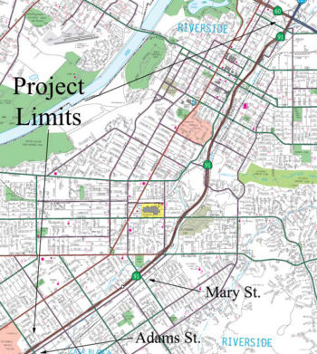 There is also a TCRP project that is adding HOV lanes
between Adams Street and the Route 91/I-215/Route 60 junction. In January
2007, the CTC processed a request to reallocate some funds on this project
and to update the completion schedule. The overall project consists of
adding one HOV lane in each direction on Route 91 from Adams Street to the
Route 60/91/215 Junction in Riverside County. The project also includes
modifying the interchange, constructing retaining walls and soundwalls,
and widening and reconstructing the existing roadway and bridges. Stage 1
of the project (Project #62.1) consists of widening Route 91 to provide
one HOV lane in each direction from University Avenue to the 60/91/215
Junction. This project was selected in May 2001 as one of the pilot
projects using Design Sequencing. The project was awarded in February
2004. The transfer of $16,300,000 from Project #62 to Project #62.1 is
necessary to cover cost increases due to bid item quantity adjustments,
unforeseen utility relocations, and adjustments to environmental and right
of way mitigation for related changes. In order to fully fund Project #62,
the Department is currently proposing to add $161,490,000 in Corridor
Mobility Improvement Account (CMIA) funding. The final phase is now
scheduled to finish in FY 2011/2012. In July 2010, the project was amended
to increase the costs: specifically, the following changes were made:
increase Environmental (PA&ED) from $2,681,000 to $3,193,000; increase
Plans, Specifications, and Estimate (PS&E) from $13,070,000 to
$20,262,000; increase Right of Way (R/W) from $31,682,000 to $62,157,000;
increase Construction Support from $14,598,000 to $20,598,000; and
decrease Construction Capital from $177,146,000 to $171,146,000.
There is also a TCRP project that is adding HOV lanes
between Adams Street and the Route 91/I-215/Route 60 junction. In January
2007, the CTC processed a request to reallocate some funds on this project
and to update the completion schedule. The overall project consists of
adding one HOV lane in each direction on Route 91 from Adams Street to the
Route 60/91/215 Junction in Riverside County. The project also includes
modifying the interchange, constructing retaining walls and soundwalls,
and widening and reconstructing the existing roadway and bridges. Stage 1
of the project (Project #62.1) consists of widening Route 91 to provide
one HOV lane in each direction from University Avenue to the 60/91/215
Junction. This project was selected in May 2001 as one of the pilot
projects using Design Sequencing. The project was awarded in February
2004. The transfer of $16,300,000 from Project #62 to Project #62.1 is
necessary to cover cost increases due to bid item quantity adjustments,
unforeseen utility relocations, and adjustments to environmental and right
of way mitigation for related changes. In order to fully fund Project #62,
the Department is currently proposing to add $161,490,000 in Corridor
Mobility Improvement Account (CMIA) funding. The final phase is now
scheduled to finish in FY 2011/2012. In July 2010, the project was amended
to increase the costs: specifically, the following changes were made:
increase Environmental (PA&ED) from $2,681,000 to $3,193,000; increase
Plans, Specifications, and Estimate (PS&E) from $13,070,000 to
$20,262,000; increase Right of Way (R/W) from $31,682,000 to $62,157,000;
increase Construction Support from $14,598,000 to $20,598,000; and
decrease Construction Capital from $177,146,000 to $171,146,000.
In 2007, the CTC recommended that the Corridor Mobility Improvement Account (CMIA) fund construction of HOV lanes between Adams St and the Route 60/Route 91/I-215 interchange ($157,198K). They did not recommend funding the Route 71/Route 91 interchange and connectors ($99,014K).
By December 2007, a mitigated Negative EIR had been received on this project, as the project will involve construction activities in an area that is habitat to the Stephen’s kangaroo rat, a federally listed threatened species. The project will also result in the disturbance of riparian habitat. The total estimated project cost, support and capital, is now $232,777,000, provided by $24,263,000 in Regional Improvement Program funds, $3,700,000 in Traffic Congestion Relief Program funds, $47,616,000 in Congestion Mitigation and Air Quality funds, and $157,198,000 in Corridor Mobility Improvement Account funds. It is now estimated to begin construction in Fiscal Year 2010-11.
In August 2011, the CTC approved $157.2 million in funding from the state's Prop. 1B bond program, which voters approved in 2006, to add a car pool lane to Route 91 from Adams Street to the Route 60/Route 91/I-215 interchange.
In January 2012, it was reported that the project to
widen Route 91 in Riverside will cost between $17 million and $21 million
more than initially estimated because the job’s low bidder has been
disqualified. Officials opened bids on 12/8/2011 for the project to add
car pool lanes along six miles of east- and westbound Route 91 from Adams
Street to the Route 60/Route 91/I-215 interchange. Since then, contractors
and Caltrans officials have traded letters and worked to resolve a host of
issues ranging from estimates of how long the job would take to not
including enough minority contractors in the process. A Southern
California Congresswoman also has weighed in on behalf of companies in her
district, according to letters associated with the project. Atkinson
Construction was the apparent low bidder, estimating that it could build
the lanes for $108.2 million, nearly $18 million lower than any of the
competitors for the job. Less than two weeks later, the company was deemed
“noncompliant” because it failed to submit certifications for
painting standards and because Atkinson used a different way of
calculating how many days the job would take, compared to other companies.
SEMA Construction, which had the second-lowest bid at $125.9 million,
called Atkinson’s claim they could build the project in 212 days
“irresponsible” and “unrealistic” in a letter
protesting the Atkinson bid to Caltrans officials six days after the bids
were opened. Caltrans officials disqualified Atkinson on Dec. 20, and said
SEMA was the lowest responsive bidder. Soon after, a fencing subcontractor
for Atkinson protested SEMA’s bid, saying the company failed to meet
a 7 percent goal of hiring minority contractors. The same complaint to
SEMA’s bid was raised by Rep. Judy Chu, D-Monterey Park, and
Flatiron Construction, who submitted the third-lowest bid on the car pool
lane project. SEMA is moving forward with the bid, saying they acted in
good faith to try to partner with minority businesses but fell short of
the 7% goal. Caltrans can award a contract to a company that doesn’t
meet the minority hiring standard if the company can demonstrate it did
enough to solicit job estimates from minority-owned subcontractors.
(Source: Press-Enterprise, 1/25/2012)
In March 2012, ground was broken for the Route 91
widening. This will complete the HOV lane from Los Angeles County to the
junction with Route 60. Construction of the $232 million project is being
overseen by Caltrans. SEMA Construction is the general contractor. About
1,500 jobs will be created by the project, according to estimates.
Completion is scheduled for late 2015. According to SEMA’s bid, it
has 570 working days — about 2½ years — to finish the
job. That doesn’t count utility relocations and land clearing that
has already happened. For example, since early 2011, crews have been
working relocating water, electrical and gas lines beneath, atop and along
the freeway. For example, crews installed new electrical lines and power
poles around the Arlington Avenue exit ramp from westbound Route 91, to
allow for the ramp’s redesign. The construction will affect downtown
Riverside. 14th Street, one of the city’s busiest ingress
and egress points to downtown offices, will be cut in half. The entire
bridge will be replaced with a new overpass, one portion at a time.
Entrance and exit ramps to the new 14th Street bridge also will
get a serious update. The new ramps will be braided, like those along
I-215 in San Bernardino near Inland Center Drive, so that traffic getting
on the freeway and exiting drivers do not conflict. 14th Street
will never close entirely for an extended period, but Ivy Street and
Cridge Street will close so crews can demolish the bridges and replace
them. The railroad bridge between Cridge and Ivy is also coming down and
being replaced so that it can span the widened freeway.
(Source: Press-Enterprise, 4/3/2012)
In June 2019, the CTC allocated $4,272,000 for the
locally-administered Local Partnership Program (LPP) (Formulaic) Pachappa
Underpass (Route 91 HOV Remnant Work) project (PPNO 1239) (08-RIV-91
18.4/20.7) (PPNO 08-1239 ProjID 0816000080). Route 91 in Riverside County,
complete the remaining work associated with the Union Pacific Railroad
line along Pachappa Underpass by paving the auxillary lanes and shoulder
of westbound Route 91 and constructing a full structure section for the
second right turn lane for the Mission Inn Avenue westbound exit ramp.
(June 2019 CTC Minutes, Agenda Item 2.5s.(2))
In May 2017, the CTC authorized relinquishment of right of way in the city of Riverside along Route 91 on Mulberry Street and Lime Street (08-Riv-91 PM 19.92/20.37), consisting of collateral facilities. The City, by freeway agreement dated July 13, 2010, agreed to accept title upon relinquishment by the State. The 90-day notice period expires April 30, 2017.
Route 91/I-215/Route 60 Connector (~ RIV 21.497)
There is a significant project to reconstruct the Route 91/I-215/Route 60 interchange. The project includes rebuilding the Spruce Street bridge; relocating the existing eastbound on-ramp to Route 60 from Orange Street to Main Street; and widening the existing highway undercrossing bridges at University Avenue, Mission Inn Avenue and Third Street. There are also plans to replace the existing southbound (to I-215) loop ramp with a direct freeway-to-freeway connector, as well as replacing the northbound to westbound (to Route 91) loop ramp with a direct freeway-to-freeway connector. There are also plans to remove the existing I-215 southbound off-ramp and northbound on-ramp at Spruce Street. These ramps will be relocated to Route 91 as an eastbound off-ramp and a westbound on-ramp at the new Spruce Street overcrossing bridge. The project will also realign East La Cadena Drive between 1st and Spruce Street, and provide a grade separation at the railroad crossing, as well as realigning West La Cadena Drive to accommodate the new interchange connectors. The Route 91 main line will be widened, and auxiliary lanes added between University and the 60/91/215 interchange. Additionally, I-215 (Route 60) will be widened from the 60/91/215 interchange to the 60/215 junction, including extending the existing carpool lanes from University Avenue to the 60/215 junction, and providing auxiliary lanes leading to and departing from the new freeway connectors. The existing I-215 (Route 60) Blaine Street, Iowa Avenue and Linden Street overcrossing bridges will be reconstructed to span the new freeway widening, and the existing I-215 (Route 60) Blaine Street, University Avenue and Central Avenue/Watkins Drive interchanges will be improved, including ramp widening. Sycamore Canyon Boulevard will be realigned at Central Avenue. The project will construct a new interchange at Martin Luther King Boulevard, and remove the existing El Cerrito Drive interchange. The existing railroad overhead bridges at Down Street and Chicago Avenue will be widened. At the 60/215 junction, a truck by-pass connector will be constructed from southbound I-215 to eastbound Route 60 and southbound I-215. On Route 60, the existing Day Street interchange will be modified. On I-215, the Box Springs Road interchange will be rebuilt with an overcrossing bridge. Lastly, there will be a a concrete barrier on northbound I-215 at the junction to westbound Route 60. This project has taken three years, cost over $317-million, and should conclude in Spring 2008. Caltrans officials plan to open two new connector ramps by the end of 2007, including one that soars 72 feet high and measures just over a mile long.
Freeway from Route 110 to Route 215; planned as freeway, never upgraded, between Route 405 and Route 110. The first segment (as freeway) opened in 1968; the last segment opened in 1975.
Orange-Riverside County Connector
The SAFETEA-LU act, enacted in August 2005 as the reauthorization of TEA-21, provided the following expenditures on or near this route:
The Irvine Company has proposed stacking a freeway on top of railroad tracks through Santa Ana Canyon to relieve traffic on the Riverside Freeway. The 10-mile freeway would be built above a heavily traveled rail line from Interstate 15 in Riverside County to the Foothill tollway in northeast Orange County, running parallel to the Riverside Freeway. The result would be side-by-side freeways passing through the canyon that links Orange and Riverside counties. In 2005, the estimate for construction of a double-deck, elevated road would be $50 million to $80 million per mile. The cost to build a 10-mile, six-lane freeway could be anywhere from $360 million to $4.8 billion.
There have also been proposals to ease traffic by drilling a tunnel or carving a highway through the Cleveland National Forest. The tunnel proposal involves an 11-mile tunnel that would run from Route 133 in Irvine to Cajalco Road at I-15. A different tunnel proposed by the Riverside County Building Industry Assn. would cut through the mountains from Interstate 15 and loop back to the Riverside Freeway, where it would connect to the Foothill tollway along four miles of double-decked lanes. Again, this tunnel would connect to Cajalco Road, which turns into the Ramona Expressway and runs past the former March Air Reserve Base, one of the region's newest cargo airports. According to a 2005 report, two route options (for new relivier routes) currently under study call for building one or more tunnels from the I-15 Freeway through the Cleveland National Forest to Orange County. One starts at Cajalco Road in Corona and the other at Lake Street or Nichols Road in Lake Elsinore. Both tie in near the Route 133/Route 241 interchange in Irvine. Either route could have one continuous tunnel at least 10 miles long or multiple shorter tunnels.
In 2002, motorists made about 250,000 trips a day on the Riverside Freeway. In 2005, Route 91 — which now includes four toll lanes — carries 264,000 cars a day. In 2020, there could be as many as 452,000. As the population grows, the traffic slows — down to 5 mph now during rush hour. The state has even gotten into the act; ACR 81, passed in 2002, calls for a study for such a Riverside to Orange County Transportation Corridor. The North County Times had an article on a commuter meeting on this route that explored five corridors: existing Route 91; the parallel railroad corridor to the north; Lake Street/Nichols Road and I-15 in Lake Elsinore to Route 133 and Route 241 in Orange County; Cajalco Road and I-15 in south Corona to Route 133 and Route 241; and the Ortega Highway (Route 74). Within each corridor, there are multiple options. Freeways, railroad tracks and exclusive bus lanes all are on the table. All told, there are a dozen potential fixes under study, all entailing a different mix of potential improvements. One final preferred fix is expected to be named in December 2005, when a $3.3 million study is completed.
According to the Orange County Register, a November 2005 study suggested that lanes should be added to Route 91 to ease congestion, and commuters should be encouraged to use the Route 241 toll road instead of Route 55. The report also recommended that an elevated roadway parallel to the 91 should be further explored and a detailed geotechnical study should be conducted on the proposed tunnel beneath the Cleveland National Forest to learn if the water table makes such a concept too expensive - and a reason to drop the idea. Specifically, the study suggested adding lanes to Route 91 in segments, up to three lanes in one stretch. Building them and other freeway improvements would cost $670 million. It is also suggested to reduce the tolls on Route 241 to encourage traffic to take that route. In compensation, the Orange and Riverside transportation agencies would build additional lanes for the toll road web. If enough added cars and trucks jump onto Route 241 and related toll roads, enough tolls would be collected to cover the reduced price of the toll. Widening the lanes and other changes could cost $470 million. There is also the possibility of creating a roadway just north of Route 91 for a four-lane, mostly elevated highway that could go over wildlife corridors; this would cost an estimated $2.7 billion. The tunnel approach, as well as widening Route 74, are currently cost prohibitive, and potentially geologically prohibitive.
As more details emerged, the plan proposed a freeway through the forest and a double-decking Route 91. Specifically, the regional transportation panel decided to recommend building those new roads, and add a few lanes to the 91, to accommodate the roughly 450,000 cars forecast to travel daily between the counties by 2030. The panel didn't specify whether the forest freeway, extending from I-15 and Cajalco Road to Irvine, would go either in a long, continuous tunnel under the Santa Ana Mountains or a series of short tunnels interspersed with overland highway sections. It would not be built entirely above ground through the Cleveland National Forest, however. If transportation officials wanted to put all traffic on Route 91, they would need to widen it to 22 lanes. The $10 billion preferred plan does call for some widening on Route 91 in Riverside County, to match the number in Orange County, Rahimian said. With those improvements in place, officials could accommodate the forecast growth either by constructing a six-lane elevated highway over the 91, or punching a six-lane freeway through the forest. Cost projections include $6 billion for the forest-tunnel highway. The Corona elevated highway's price tag is pegged at $2.7 billion. [The] second deck would partially cover Route 91 and would run between I-15 and Route 241 toll road in Orange County. It would empty directly onto Route 241.
![[Linkj to Press Enterprise Image]](maps/091-tunnel.jpg) In February 2010, it was reported that an 11.5-mile
tunnel between Corona and Irvine through the Santa Ana Mountains is
technically feasible and deserves more study, although it is well out of
the price range of public agencies. Based on the tests by Irvine-based
engineering firm Kleinfelder, there are no "fatal flaws" in building a
52-foot-wide tunnel to carry traffic and another smaller tunnel for
passenger rail service and a water line. But obstacles remain, much as
they did in 2007 when the feasibility study was started. Engineers have
said since 2008 that the tunneling would require larger boring machines
than have ever been built, and designers will have to find an answer for
how to ventilate the tunnel that isn't damaging to the forest above. The
estimated cost to build one of the two 53-foot tunnels and the 27-foot
hole for rail and water company use would be nearly $8.6 billion. The
route would be roughly from the Route 133/Route 241 junction to Caljaco
Road and I-15. Currently, the counties are investigating if they could
borrow for construction based on anticipated tolls. The price of a one-way
trip through the tunnel is estimated to vary between $4 and $20, depending
on the time of day, according to a report presented to the bi-county
authority. The tunnel would be used in one direction in the morning, then
reverse course in the evening to handle rush-hour traffic. Construction
would not start until 2019 and take a decade, according to the current
schedule.
In February 2010, it was reported that an 11.5-mile
tunnel between Corona and Irvine through the Santa Ana Mountains is
technically feasible and deserves more study, although it is well out of
the price range of public agencies. Based on the tests by Irvine-based
engineering firm Kleinfelder, there are no "fatal flaws" in building a
52-foot-wide tunnel to carry traffic and another smaller tunnel for
passenger rail service and a water line. But obstacles remain, much as
they did in 2007 when the feasibility study was started. Engineers have
said since 2008 that the tunneling would require larger boring machines
than have ever been built, and designers will have to find an answer for
how to ventilate the tunnel that isn't damaging to the forest above. The
estimated cost to build one of the two 53-foot tunnels and the 27-foot
hole for rail and water company use would be nearly $8.6 billion. The
route would be roughly from the Route 133/Route 241 junction to Caljaco
Road and I-15. Currently, the counties are investigating if they could
borrow for construction based on anticipated tolls. The price of a one-way
trip through the tunnel is estimated to vary between $4 and $20, depending
on the time of day, according to a report presented to the bi-county
authority. The tunnel would be used in one direction in the morning, then
reverse course in the evening to handle rush-hour traffic. Construction
would not start until 2019 and take a decade, according to the current
schedule.
(Source: "OC-RivCo tunnel feasible, but pricey", Dug Begley, Riverside Press Enterprise, 2/3/2010)
In July 2010, it was reported that although the tunnel was technically feasible, it was economically infeasible. At a cost of $8.6 billion, it's simply too expensive, especially since officials can't start collecting tolls until after they spend 10 years building it. The proposed 11.2-mile tunnel also faces technical and environmental issues that could slow or stop construction. The notion right now is to make the project low priority until something changes -- technology improves so much that construction costs drastically drop, they receive a large bundle of money, etc. Backers are hopefull that groundwater monitoring at least will continue. To meet rules regarding construction in national forests, 10 years of groundwater monitoring must be compiled. If officials suspend the $30,000-a-month monitoring, they would have to start all over again if the project were revived. The image to the right shows some of the issues.
 Commuter Lanes
Commuter lanes exist for all of Route 91 in Los Angeles County. The eastbound lanes between Central Avenue and I-605 were opened in 1985; westbound between I-110 and I-605 in 1993, and between I-605 and the Los Angeles county line in 1994.
In Orange County, HOV lanes exist between 0.2 mi E of the Route 57 interchange and the Riverdale Avenue overcrossing. HOVs also may use the Route 91 toll road for free between the Los Angeles/Orange County line and the Orange/Riverside County line. All these lanes opened in December 1995, and are always in operation. Lanes also exists from the Los Angeles County line to 0.3 mi E of Stanton Avenue; and from 0.2 mi E of Gilbert to 0.3 mi W of La Palma. Construction started on these lanes in January 1997.
In Riverside County, HOV lanes exist between the Orange County line and Mary Street. The portion between the Orange County line and Magnolia Avenue opened in September 1992; the remainder (between Magnolia Avenue and Mary Street) opened in July 1995. In May 2001, the CTC considered an Agenda Item (TCR Project #62) to construct HOV lanes from Mary Street to the Route 60/Route 215 junction. In December 2004 and January 2005, a request was made to extend the project limits for the Route 91 High Occupancy Vehicle (HOV) Lanes project (PPNO 0092A) in Riverside County to close the gap of the HOV lane in the eastbound direction, between Adams Street and Mary Street. In September 2005, the extension of the HOV lanes from Mary Street to the Route 60/Route 215 interchange was delayed. The original construction contract was awarded in February 2004 after nearly a year of delay caused by the previous suspension of allocating new TCRP funds. The need to reconcile differences between the bid package and the completed design has resulted in additional schedule delays and additional costs. The project is now scheduled to complete in June 2007.
All HOV lanes require two or more occupants, and operate 24 hours all days.
In November 2012, it was reported that the HOV lanes in Orange County had been restriped to allow entry and exit at any time ("continuous access"), as opposed to only at specific ingress and egress points.
 Naming
 Before 1991, the 4.7mi segment W of Route 710 had been named the "Redondo Beach Freeway"
(~ LA 0.000 to LA R11.545) (named by the State Highway Commission). It was
named because it traverses the City of Redondo Beach, CA, which was
founded in 1881 and apparently named after the adjoining Ranch Sausal
Redondo (round willow grove).
Before 1991, the 4.7mi segment W of Route 710 had been named the "Redondo Beach Freeway"
(~ LA 0.000 to LA R11.545) (named by the State Highway Commission). It was
named because it traverses the City of Redondo Beach, CA, which was
founded in 1881 and apparently named after the adjoining Ranch Sausal
Redondo (round willow grove).
(Image Source: Anthony R. Brooks on Facebook. The sign hangs over Long Beach Blvd in (North) Long Beach.)
 The segment of Route 91 from the western city limits of Gardena to Route 710 (~ LA
6.033 to LA R11.545) is offically named the "Gardena Freeway". It
was named by Senate Concurrent Resolution No. 16, Chapter 35, in 1991.
Gardena refers to the city of Gardena, which was derived from "garden" and
was applied to the subdivision in the 1880s.
The segment of Route 91 from the western city limits of Gardena to Route 710 (~ LA
6.033 to LA R11.545) is offically named the "Gardena Freeway". It
was named by Senate Concurrent Resolution No. 16, Chapter 35, in 1991.
Gardena refers to the city of Gardena, which was derived from "garden" and
was applied to the subdivision in the 1880s.
(Image Source: Tony Ortega via Private Message,
8/22/2021)
Proposed name for what became the Artesia Freeway. Named for the eventual destination of
Hermosa Beach. Referenced in the July/August 1955 issue of California
Highways & Public Works, which featured construction of US 101 along
the Santa Ana Freeway south of Anaheim and the LRN 175 Freeway (Sign Route 14) east of LRN 180 to LRN 43. The Santa Ana Freeway between 1st
Street and Browning Avenue near Santa Ana/Tustin was cited to be 70%
complete. The Route 175 Freeway is noted to referenced locally as
the "Orangethorpe Freeway" and approximately 50% complete. The
planned LRN 175 Freeway west of US 101 is referenced as the "Artesia
Freeway" and "Hermosa Beach Freeway."
(Source: Gribblenation Blog (Tom Fearer), "California State Route 14 (i)", 10/10/2023)
 Bridge 53-958 on I-110, the I-110/Route 91 interchange
(~ LA 6.322), is named the "Edmond J. Russ Interchange". It was
built in 1985, and was named by Assembly Concurrent Resolution 135,
Chapter 162. [Note: According to the CalTrans logs, this bridge is
actually on Route 110; thus the named interchange is at the Route 110/Route 91 junction.] Ed Russ is a former mayor of Gardena; during his
term (which ended in 1982) he was able to push for the extension of the
then Redondo Beach Freeway to the Route 110. This extension relieved the
traffic that plagued Atresia Blvd from the end of the freeway at Broadway
to Route 110. When the extension was completed in 1985, it was given the
legislative name in his honor, but it was up to the private sector to
produce the funds to make and install the signs for the interchange. It
wasn't until 1998-99 that a group of Gardena businesspeole and citizens,
led by the Gardena Valley News, began a campaign to raise the money
needed. The signs were installed in the latter half of 1999.
Bridge 53-958 on I-110, the I-110/Route 91 interchange
(~ LA 6.322), is named the "Edmond J. Russ Interchange". It was
built in 1985, and was named by Assembly Concurrent Resolution 135,
Chapter 162. [Note: According to the CalTrans logs, this bridge is
actually on Route 110; thus the named interchange is at the Route 110/Route 91 junction.] Ed Russ is a former mayor of Gardena; during his
term (which ended in 1982) he was able to push for the extension of the
then Redondo Beach Freeway to the Route 110. This extension relieved the
traffic that plagued Atresia Blvd from the end of the freeway at Broadway
to Route 110. When the extension was completed in 1985, it was given the
legislative name in his honor, but it was up to the private sector to
produce the funds to make and install the signs for the interchange. It
wasn't until 1998-99 that a group of Gardena businesspeole and citizens,
led by the Gardena Valley News, began a campaign to raise the money
needed. The signs were installed in the latter half of 1999.
(Image source: Freeway City)
 The westbound portion of Route 91
between Figueroa Street and Central Avenue (~ LA R6.534 to LA R8.444), in
the City of Carson is officially named the "Rudolph B. Davila Memorial
Freeway" This segment was named in memory of Rudolph B. Davila, who
was born in El Paso, Texas, and was raised in Watts, California. As a
young man during the Depression, he worked in vineyards and helped restore
the California missions as part of the Civilian Conservation Corps. During
World War II, Rudolph B. Davila helped take out several machine gun nests
and prevented a 130-man American rifle company from being slaughtered in a
German ambush in Italy. According to his Medal of Honor citation,
Davila’s machine gunners were caught on an exposed hillside by heavy
grazing fire from a well-entrenched Germany force and were reluctant to
risk putting their guns into action. Davila crawled 50 yards to the
nearest machine gun, set it up alone and opened fire on the enemy. In
order to observe the effect of his fire, Davila fired from the kneeling
position, ignoring the enemy fire that struck the tripod and passed
between his legs. Ordering a gunner to take over, Davila crawled forward
to a vantage point and directed the firefight with hand and arm signals
until both hostile machine guns were silenced. Bringing his three
remaining machine guns into action, Davila drove the enemy to a reserve
position 200 yards to the rear. When Davila received a painful wound in a
leg, he dashed to a burned tank and despite the crash of bullets on the
hull, engaged a second enemy force from the tank’s turret.
Dismounting, he advanced 130 yards in short rushes, crawled 20 yards and
charged into an enemy-held house to eliminate the defending force of five
with a hand grenade and rifle fire. Climbing to the attic, he straddled a
large shell hole in the wall and opened fire on the enemy. Although the
walls of the house were crumbling, he continued to fire until he had
destroyed two more machine guns. Davila’s “intrepid actions
brought desperately needed heavy weapons support to a hard-pressed rifle
company and silenced four machine gunners, which forced the enemy to
abandon their prepared positions,” the citation read. Davila
received a battlefield commission to second lieutenant and was initially
awarded the Distinguished Service Cross, the Army’s second-highest
honor. His wife, Harriet, lobbied Army officials for years to award her
husband the Medal of Honor. A captain in the rifle company had said he
would recommend Davila for the Medal of Honor. On June 21, 2000, 56 years
later, Rudolph B. Davila, who was of Filipino and Spanish descent, along
with 20 other Asian American World War II veterans, received a Medal of
Honor from President Bill Clinton at a White House ceremony after an army
panel reviewed their wartime actions and deemed them worthy of the
nation's highest commendation for battlefield bravery. Rudolph B. Davila
earned the medal for his extraordinary heroism during the offensive that
broke through the German mountain strongholds surrounding the Anzio
beachhead in May 1944. When asked what made him rise to his knees with a
machine gun while his fellow soldiers hugged the ground, Rudolph B. Davila
said, "I knew what I was fighting for, and most of the kids didn't," he
said, ascribing his self-assuredness to accounts he had read of Hitler. "I
had this fervour about the defense of freedom, even though I couldn't
define freedom. I just knew we were going to be enslaved to Hitler if we
didn't defeat him." The war ended for Rudolph B. Davila in late 1944 when
a tank round exploded in a tree and shrapnel ripped into his right
shoulder. Over the next six years, he underwent 13 operations on his arm
and met his wife, Harriet, at a military hospital in San Francisco,
California. After the war, Rudolph B. Davila earned bachelor's and
master's degrees in sociology from the University of Southern California,
and spent 30 years as a teacher and counselor in the Los Angeles City
School District. Rudolph B. Davila was an excellent cook and gardener. He
terraced his hillside yard and built retaining walls. He also built the
family's house in Harbor City, California, and his retirement home in
Vista, California. Rudolph B. Davila died January 26, 2002, in Vista,
California, after a long illness and is survived by his children. Named by
Senate Concurrent Resolution (SCR) 107, Resolution Chapter 125, on
9/7/2010.
The westbound portion of Route 91
between Figueroa Street and Central Avenue (~ LA R6.534 to LA R8.444), in
the City of Carson is officially named the "Rudolph B. Davila Memorial
Freeway" This segment was named in memory of Rudolph B. Davila, who
was born in El Paso, Texas, and was raised in Watts, California. As a
young man during the Depression, he worked in vineyards and helped restore
the California missions as part of the Civilian Conservation Corps. During
World War II, Rudolph B. Davila helped take out several machine gun nests
and prevented a 130-man American rifle company from being slaughtered in a
German ambush in Italy. According to his Medal of Honor citation,
Davila’s machine gunners were caught on an exposed hillside by heavy
grazing fire from a well-entrenched Germany force and were reluctant to
risk putting their guns into action. Davila crawled 50 yards to the
nearest machine gun, set it up alone and opened fire on the enemy. In
order to observe the effect of his fire, Davila fired from the kneeling
position, ignoring the enemy fire that struck the tripod and passed
between his legs. Ordering a gunner to take over, Davila crawled forward
to a vantage point and directed the firefight with hand and arm signals
until both hostile machine guns were silenced. Bringing his three
remaining machine guns into action, Davila drove the enemy to a reserve
position 200 yards to the rear. When Davila received a painful wound in a
leg, he dashed to a burned tank and despite the crash of bullets on the
hull, engaged a second enemy force from the tank’s turret.
Dismounting, he advanced 130 yards in short rushes, crawled 20 yards and
charged into an enemy-held house to eliminate the defending force of five
with a hand grenade and rifle fire. Climbing to the attic, he straddled a
large shell hole in the wall and opened fire on the enemy. Although the
walls of the house were crumbling, he continued to fire until he had
destroyed two more machine guns. Davila’s “intrepid actions
brought desperately needed heavy weapons support to a hard-pressed rifle
company and silenced four machine gunners, which forced the enemy to
abandon their prepared positions,” the citation read. Davila
received a battlefield commission to second lieutenant and was initially
awarded the Distinguished Service Cross, the Army’s second-highest
honor. His wife, Harriet, lobbied Army officials for years to award her
husband the Medal of Honor. A captain in the rifle company had said he
would recommend Davila for the Medal of Honor. On June 21, 2000, 56 years
later, Rudolph B. Davila, who was of Filipino and Spanish descent, along
with 20 other Asian American World War II veterans, received a Medal of
Honor from President Bill Clinton at a White House ceremony after an army
panel reviewed their wartime actions and deemed them worthy of the
nation's highest commendation for battlefield bravery. Rudolph B. Davila
earned the medal for his extraordinary heroism during the offensive that
broke through the German mountain strongholds surrounding the Anzio
beachhead in May 1944. When asked what made him rise to his knees with a
machine gun while his fellow soldiers hugged the ground, Rudolph B. Davila
said, "I knew what I was fighting for, and most of the kids didn't," he
said, ascribing his self-assuredness to accounts he had read of Hitler. "I
had this fervour about the defense of freedom, even though I couldn't
define freedom. I just knew we were going to be enslaved to Hitler if we
didn't defeat him." The war ended for Rudolph B. Davila in late 1944 when
a tank round exploded in a tree and shrapnel ripped into his right
shoulder. Over the next six years, he underwent 13 operations on his arm
and met his wife, Harriet, at a military hospital in San Francisco,
California. After the war, Rudolph B. Davila earned bachelor's and
master's degrees in sociology from the University of Southern California,
and spent 30 years as a teacher and counselor in the Los Angeles City
School District. Rudolph B. Davila was an excellent cook and gardener. He
terraced his hillside yard and built retaining walls. He also built the
family's house in Harbor City, California, and his retirement home in
Vista, California. Rudolph B. Davila died January 26, 2002, in Vista,
California, after a long illness and is survived by his children. Named by
Senate Concurrent Resolution (SCR) 107, Resolution Chapter 125, on
9/7/2010.
(Image source: Wikipedia)
 Additionally, the portion of Route 91 in the
City of Compton from Central Avenue to Alameda St. (~ LA R8.444 to LA
R10.306) is named the "Willard H. Murray Freeway". Willard H.
Murray was a member of the state assembly, an engineer at TRW, a
congressional aide to Mervyn Dymally, and a past chair of the Legislative
Black Caucus. He established the first institute of the preservation of
jazz as an art form at Cal State Long Beach. Murray was a four-term
Assemblymember for the 52nd Assembly District. During his tenure in
the Assembly, he was a member of the Committees on Budget, Local
Government, Utilities & Commerce and Education. He served on the
Budget Subcommittee on Education, Finance, Select Committees on
California-Africa and California-Mexico Affairs, and the Joint Committee
on the Arts. He also chaired the Budget Subcommittee on State
Administration. Murray’s lifelong dedication to public service was
preceded by his active involvement in the Civil Rights
Movement during the 1950s and 1960s, and as a pioneer with his state
legislation requiring literacy programs for incarcerated adults and youth
to curb recidivism. Named by Assembly Concurrent Resolution 78, Chapter
135, in 1997.
Additionally, the portion of Route 91 in the
City of Compton from Central Avenue to Alameda St. (~ LA R8.444 to LA
R10.306) is named the "Willard H. Murray Freeway". Willard H.
Murray was a member of the state assembly, an engineer at TRW, a
congressional aide to Mervyn Dymally, and a past chair of the Legislative
Black Caucus. He established the first institute of the preservation of
jazz as an art form at Cal State Long Beach. Murray was a four-term
Assemblymember for the 52nd Assembly District. During his tenure in
the Assembly, he was a member of the Committees on Budget, Local
Government, Utilities & Commerce and Education. He served on the
Budget Subcommittee on Education, Finance, Select Committees on
California-Africa and California-Mexico Affairs, and the Joint Committee
on the Arts. He also chaired the Budget Subcommittee on State
Administration. Murray’s lifelong dedication to public service was
preceded by his active involvement in the Civil Rights
Movement during the 1950s and 1960s, and as a pioneer with his state
legislation requiring literacy programs for incarcerated adults and youth
to curb recidivism. Named by Assembly Concurrent Resolution 78, Chapter
135, in 1997.
(Image source: Water Replenishment District)
The segment of Route 91 from Route 710 to Route 5 in Fullerton (~ LA R11.717 to ORA R3.548R) is named the "Artesia Freeway". Named by Assembly Concurrent Resolution 80, Chapter 148 in 1970. The resolution itself does not give the rationale for the naming; it is believed to be because the route parallels Artesia Blvd., and this segment goes through Artesia. Although the name is in common usage, there does not appear to be any signage that uses the name.
Proposed name for what became the Riverside Freeway. Named for Houston Avenue, which the route
parallels. Referenced in the July/August 1956 issue of California Highways
& Public Works, which featured the opening of the Houston Expressway
(Sign Route 14/US 91/Sign Route 18/LRN 175) east of LRN 180/Cypress Avenue
to Santa Ana Canyon. An opening ceremony was held in Anaheim, but
the article does not specify a date.
(Source: Gribblenation Blog (Tom Fearer), "California State Route 14 (i)", 10/10/2023)
Proposed name for what became the Riverside Freeway. Named for Orangethorpe Avenue, which the
route parallels. Referenced in the July/August 1955 issue of California
Highways & Public Works, which featured construction of US 101 along
the Santa Ana Freeway south of Anaheim and the LRN 175 Freeway (Sign Route 14) east of LRN 180 to LRN 43. The Santa Ana Freeway between 1st
Street and Browning Avenue near Santa Ana/Tustin was cited to be 70%
complete. The Route 175 Freeway is noted to referenced locally as
the "Orangethorpe Freeway" and approximately 50% complete. The
planned LRN 175 Freeway west of US 101 is referenced as the "Artesia
Freeway" and "Hermosa Beach Freeway."
(Source: Gribblenation Blog (Tom Fearer), "California State Route 14 (i)", 10/10/2023)
 The segment of Route 91 between I-605 and
Pioneer Boulevard (~ LA R16.983 to LA R18.108), in Los Angeles County, is
named the "Los Angeles County Deputy Sheriff David Powell Memorial
Highway" It was named in memory of Deputy David Powell of the Los
Angeles County Sheriff's Department who was killed in the line of duty on
November 30, 2002, in the City of Artesia while conducting an
investigation. Deputy Powell was a resident of Torrance and a graduate of
Loyola Marymount University. Deputy Powell stated the reason he became a
law enforcement officer was to make a positive difference in other people'
s lives, and as a deputy sheriff, he was praised by his peers,
supervisors, and members of the community for his tireless efforts to
guide young people away from drugs and gangs. Deputy Powell was awarded
the Medal of Valor by the City of Lakewood for saving the life of an
individual attempting suicide in the year 2000, and several months prior
to his death, Deputy Powell tried desperately to remove critically injured
passengers from a burning vehicle and was again honored for his heroic
actions with a second Medal of Valor. Named by Assembly Concurrent
Resolution (ACR) 30, Resolution Chapter 47, on 6/9/2009.
The segment of Route 91 between I-605 and
Pioneer Boulevard (~ LA R16.983 to LA R18.108), in Los Angeles County, is
named the "Los Angeles County Deputy Sheriff David Powell Memorial
Highway" It was named in memory of Deputy David Powell of the Los
Angeles County Sheriff's Department who was killed in the line of duty on
November 30, 2002, in the City of Artesia while conducting an
investigation. Deputy Powell was a resident of Torrance and a graduate of
Loyola Marymount University. Deputy Powell stated the reason he became a
law enforcement officer was to make a positive difference in other people'
s lives, and as a deputy sheriff, he was praised by his peers,
supervisors, and members of the community for his tireless efforts to
guide young people away from drugs and gangs. Deputy Powell was awarded
the Medal of Valor by the City of Lakewood for saving the life of an
individual attempting suicide in the year 2000, and several months prior
to his death, Deputy Powell tried desperately to remove critically injured
passengers from a burning vehicle and was again honored for his heroic
actions with a second Medal of Valor. Named by Assembly Concurrent
Resolution (ACR) 30, Resolution Chapter 47, on 6/9/2009.
(Image source: LA County Sheriffs on Twitter, Daily Breeze)
 Nixon") The portion of Route 91, from the Pioneer Boulevard undercrossing (~ LA R18.098) to the
Carmenita Road overcrossing (~ LA R20.447), is named the “First
Lady Pat Nixon Memorial Highway”. It was named in memory of
First Lady Pat Nixon, who was born Thelma Catherine Ryan in Ely, Nevada on
March 16, 1912. She was given the nickname Patricia, or “Pat”
by her father because she was born just hours shy of Saint Patrick’s
Day. Mrs. Nixon attended Pioneer Boulevard Grammar School in the City of
Artesia (now the City of Cerritos), California and Excelsior High School
in the City of Norwalk, California. Mrs. Nixon graduated from the
University of Southern California in 1937, becoming the first Presidential
First Lady to earn a graduate degree, and subsequently began teaching at
Whittier Union High School in the City of Whittier, California. Pat met
Richard Nixon in February 1938 and they married two years later in the
City of Riverside, California. The couple had two daughters, Patricia and
Julie Nixon. Throughout her lifetime of service, Mrs. Nixon fundamentally
transformed the roles of both Second Lady and First Lady, redefining them
for an entire generation of people who would follow her. In 1953, then
Second Lady Pat Nixon, as wife of the Vice President of the United States,
led an extensive two-month tour through Asia and the Pacific, including
visiting Cambodia, Korea, Vietnam, and Japan. On January 20, 1969, Pat
Nixon became the First Lady of the United States of America. Mrs. Nixon
championed and supported the societal advancement of women and girls by
endorsing the Equal Rights Amendment, becoming the first Presidential
First Lady to wear pants in public, and advocating for the appointment of
a woman to the United States Supreme Court. Mrs. Nixon championed
volunteer service and donated personal time and efforts to furthering the
charitable missions of such notable volunteer organizations as The
Salvation Army, the Girl Scouts of the United States of America, and the
American Red Cross. In July 1969, Mrs. Nixon visited American troops in
South Vietnam, becoming the first Presidential First Lady to travel to a
combat zone. Pat Nixon’s travels as First Lady included the historic
visit to the People’s Republic of China, summit meetings in the
former Soviet Union, and diplomatic missions to Ghana, Liberia, and
Côte d’Ivoire, as well as a journey of compassion to take
relief supplies to earthquake victims in Peru. Mrs. Nixon became known as
“America’s Ambassador of Goodwill” for her travels to 83
different countries around the world, the most of any First Lady. First
Lady Pat Nixon died at home in Park Ridge, New Jersey on June 22, 1993,
and is buried at the Richard Nixon Presidential Library and Museum in the
City of Yorba Linda, California. Named by Senate Resolution SCR 68, Res. Chapter 103, 08/01/22.
The portion of Route 91, from the Pioneer Boulevard undercrossing (~ LA R18.098) to the
Carmenita Road overcrossing (~ LA R20.447), is named the “First
Lady Pat Nixon Memorial Highway”. It was named in memory of
First Lady Pat Nixon, who was born Thelma Catherine Ryan in Ely, Nevada on
March 16, 1912. She was given the nickname Patricia, or “Pat”
by her father because she was born just hours shy of Saint Patrick’s
Day. Mrs. Nixon attended Pioneer Boulevard Grammar School in the City of
Artesia (now the City of Cerritos), California and Excelsior High School
in the City of Norwalk, California. Mrs. Nixon graduated from the
University of Southern California in 1937, becoming the first Presidential
First Lady to earn a graduate degree, and subsequently began teaching at
Whittier Union High School in the City of Whittier, California. Pat met
Richard Nixon in February 1938 and they married two years later in the
City of Riverside, California. The couple had two daughters, Patricia and
Julie Nixon. Throughout her lifetime of service, Mrs. Nixon fundamentally
transformed the roles of both Second Lady and First Lady, redefining them
for an entire generation of people who would follow her. In 1953, then
Second Lady Pat Nixon, as wife of the Vice President of the United States,
led an extensive two-month tour through Asia and the Pacific, including
visiting Cambodia, Korea, Vietnam, and Japan. On January 20, 1969, Pat
Nixon became the First Lady of the United States of America. Mrs. Nixon
championed and supported the societal advancement of women and girls by
endorsing the Equal Rights Amendment, becoming the first Presidential
First Lady to wear pants in public, and advocating for the appointment of
a woman to the United States Supreme Court. Mrs. Nixon championed
volunteer service and donated personal time and efforts to furthering the
charitable missions of such notable volunteer organizations as The
Salvation Army, the Girl Scouts of the United States of America, and the
American Red Cross. In July 1969, Mrs. Nixon visited American troops in
South Vietnam, becoming the first Presidential First Lady to travel to a
combat zone. Pat Nixon’s travels as First Lady included the historic
visit to the People’s Republic of China, summit meetings in the
former Soviet Union, and diplomatic missions to Ghana, Liberia, and
Côte d’Ivoire, as well as a journey of compassion to take
relief supplies to earthquake victims in Peru. Mrs. Nixon became known as
“America’s Ambassador of Goodwill” for her travels to 83
different countries around the world, the most of any First Lady. First
Lady Pat Nixon died at home in Park Ridge, New Jersey on June 22, 1993,
and is buried at the Richard Nixon Presidential Library and Museum in the
City of Yorba Linda, California. Named by Senate Resolution SCR 68, Res. Chapter 103, 08/01/22.
(Image source: Wikiwand)
 The interchange of I-5 and Rout 91 (~ ORA R3.548R) in the City of Fullerton is named the “Fullerton
Police Detective Tommy De La Rosa Memorial Interchange”. It
was named in memory of Fullerton Police Detective Tommy De La Rosa, who at
43 years of age paid the ultimate sacrifice in the line of duty. Detective
De La Rosa was born on May 12, 1947, and served his country during the
Vietnam War while in the Marine Corps. Detective De La Rosa joined the
Fullerton Police Department on September 26, 1980. While off duty,
Detective De La Rosa liked to speak with children from neighborhoods heavy
with drugs, gangs, and prostitution and urge them to be good and stay in
school. On June 21, 1990, Detective De La Rosa was ambushed and shot five
times during an undercover reverse sting narcotics operation, but,
although gravely injured, was still able to return fire and fatally wound
one of the suspects before succumbing to his injuries. Three other
suspects were convicted of Detective De La Rosa’s murder and were
sentenced to life without parole. Detective De La Rosa provided the public
with exemplary service and dedication to his job throughout his nine-year
career with the Fullerton Police Department. Named by Senate Concurrent
Resolution (SCR) 28, Res. Chapter 128, Statutes of 2015, on July 22, 2015.
The interchange of I-5 and Rout 91 (~ ORA R3.548R) in the City of Fullerton is named the “Fullerton
Police Detective Tommy De La Rosa Memorial Interchange”. It
was named in memory of Fullerton Police Detective Tommy De La Rosa, who at
43 years of age paid the ultimate sacrifice in the line of duty. Detective
De La Rosa was born on May 12, 1947, and served his country during the
Vietnam War while in the Marine Corps. Detective De La Rosa joined the
Fullerton Police Department on September 26, 1980. While off duty,
Detective De La Rosa liked to speak with children from neighborhoods heavy
with drugs, gangs, and prostitution and urge them to be good and stay in
school. On June 21, 1990, Detective De La Rosa was ambushed and shot five
times during an undercover reverse sting narcotics operation, but,
although gravely injured, was still able to return fire and fatally wound
one of the suspects before succumbing to his injuries. Three other
suspects were convicted of Detective De La Rosa’s murder and were
sentenced to life without parole. Detective De La Rosa provided the public
with exemplary service and dedication to his job throughout his nine-year
career with the Fullerton Police Department. Named by Senate Concurrent
Resolution (SCR) 28, Res. Chapter 128, Statutes of 2015, on July 22, 2015.
(Image source: Fullerton PD, Find a Grave)
 The segment of Route 91 from Route 5 to the
Route 60/Route 215/Route 91 (~ ORA R3.548R to RIV 21.354) interchange is
named the "Riverside Freeway". It was named by the State Highway
Commission. The first segment opened in 1958. It was named because it
traverses the City of Riverside CA, which was named in 1871 because of its
location on the banks of a channel of the Santa Ana River. The county was
named after the city in 1893. Referenced in the January/February 1958
issue of California Highways & Public Works, which announced the
Houston Expressway had been renamed the "Riverside Freeway" by the
California Highway Commission on October 25, 1957. The Riverside
Freeway corridor was defined as from the Santa Ana Freeway was to
Riverside.
The segment of Route 91 from Route 5 to the
Route 60/Route 215/Route 91 (~ ORA R3.548R to RIV 21.354) interchange is
named the "Riverside Freeway". It was named by the State Highway
Commission. The first segment opened in 1958. It was named because it
traverses the City of Riverside CA, which was named in 1871 because of its
location on the banks of a channel of the Santa Ana River. The county was
named after the city in 1893. Referenced in the January/February 1958
issue of California Highways & Public Works, which announced the
Houston Expressway had been renamed the "Riverside Freeway" by the
California Highway Commission on October 25, 1957. The Riverside
Freeway corridor was defined as from the Santa Ana Freeway was to
Riverside.
(Source for CHPW Reference: Gribblenation Blog (Tom Fearer), "California State Route 14 (i)", 10/10/2023); Image source: AARoads)
 The portion of Route 91 between Magnolia Avenue (in Buena Park) and State College
Boulevard (in Anaheim) in the County of Orange (~ ORA R3.876L to ORA
5.303) is named the "Fullerton Police Officer Jerry Hatch Memorial
Highway". Name in memory of Fullerton Police Officer Jerry Scott
Hatch. On Sunday, June 29, 1975, while on his way to work, Officer Hatch
stopped to assist a motorist with an engine fire on the Beach Boulevard
off ramp of Route 91. As he was placing his fire extinguisher back in his
trunk, Officer Hatch was struck from behind by a drunk driver. On June 30,
1975, Officer Hatch succumbed to his injuries. Officer Hatch was the first
Fullerton police officer to be killed in the line of duty; fellow officers
say that Officer Hatch’s good samaritan act was typical for him.
Officer Hatch was described as an officer who always had a smile and who
had received two citizen citations in the short six months he was on the
force. Named by Senate Concurrent Resolution (SCR) 27, Res. Chapter 109,
Statutes of 2015, on July 16, 2015.
The portion of Route 91 between Magnolia Avenue (in Buena Park) and State College
Boulevard (in Anaheim) in the County of Orange (~ ORA R3.876L to ORA
5.303) is named the "Fullerton Police Officer Jerry Hatch Memorial
Highway". Name in memory of Fullerton Police Officer Jerry Scott
Hatch. On Sunday, June 29, 1975, while on his way to work, Officer Hatch
stopped to assist a motorist with an engine fire on the Beach Boulevard
off ramp of Route 91. As he was placing his fire extinguisher back in his
trunk, Officer Hatch was struck from behind by a drunk driver. On June 30,
1975, Officer Hatch succumbed to his injuries. Officer Hatch was the first
Fullerton police officer to be killed in the line of duty; fellow officers
say that Officer Hatch’s good samaritan act was typical for him.
Officer Hatch was described as an officer who always had a smile and who
had received two citizen citations in the short six months he was on the
force. Named by Senate Concurrent Resolution (SCR) 27, Res. Chapter 109,
Statutes of 2015, on July 16, 2015.
(Image source: Behind the Badge; Officer Down Memorial Page)
 The Route 91/Route 55
interchange (~ORA R9.09) is named the "Mark Denis Melbourne Memorial
Interchange". Mark Denis Melbourne was a fixture on southern
California radio, giving traffic reports for four decades. He was regarded
as one of the most respected broadcasters in southern California and was
used as the "image voice" for KFI 640 AM. He was also a part-time
communications instructor at the University of Southern California, and
was regarded as having loved to share his knowledge of broadcasting with
others. He advocated reporting traffic without panic and with caring, and
was willing to help frustrated drivers avoid bottlenecks. He was also the
unidentified voice on the monorail that ferries visitors around
Disneyland. He died of a fatal illness in the year 2000 in his home in
Anaheim Hills at the early age of 59. Named by Senate Concurrent
Resolution 50, Chapter 104, on August 8, 2002.
The Route 91/Route 55
interchange (~ORA R9.09) is named the "Mark Denis Melbourne Memorial
Interchange". Mark Denis Melbourne was a fixture on southern
California radio, giving traffic reports for four decades. He was regarded
as one of the most respected broadcasters in southern California and was
used as the "image voice" for KFI 640 AM. He was also a part-time
communications instructor at the University of Southern California, and
was regarded as having loved to share his knowledge of broadcasting with
others. He advocated reporting traffic without panic and with caring, and
was willing to help frustrated drivers avoid bottlenecks. He was also the
unidentified voice on the monorail that ferries visitors around
Disneyland. He died of a fatal illness in the year 2000 in his home in
Anaheim Hills at the early age of 59. Named by Senate Concurrent
Resolution 50, Chapter 104, on August 8, 2002.
(Image source: The Southern Californian)
 At the junction of Route 71 (~
08-RIV-71 R2.843) and Route 91 (~ 08-RIV-91 ~ RIV R2.083) is the Prado Dam Mural. The Bicentennial Freedom Mural was originally painted by
Corona High school students in 1976. The mural was the idea of a student
from Corona High, after visiting the Freedom Train in Pomona in 1976. The
student, Terry Smith, told her Activities Coach David DiPiaolo about her
idea for the dam's spillway. David then took it to the Student Body
at Corona High, where the idea gained momentum. The Army Corps of
Engineers loved the idea of a Patriotic mural, the school ran a contest
for the best design and David contacted hardware stores in the area to
donate paint. Corona students, Ron Kammeyer and a friend came up with the
design: the Liberty Bell, and a slogan "200 YEARS OF FREEDOM". David
organized 30 students who camped out over two weekends at the dam.
Another volunteer brought some sort of projector, or possibly a laser
sight, in order to measure the mural for chalk lines. The project
was so massive they ended up pouring the paint on the spillway and used
rollers to work it in. The mural was completed in May of 1976. The
original mural design was the only approved design. Over time, the mural
deteriorated. It was repainted in 2023, with a team of volunteers donating
thousands of volunteer hours over 10 years.
At the junction of Route 71 (~
08-RIV-71 R2.843) and Route 91 (~ 08-RIV-91 ~ RIV R2.083) is the Prado Dam Mural. The Bicentennial Freedom Mural was originally painted by
Corona High school students in 1976. The mural was the idea of a student
from Corona High, after visiting the Freedom Train in Pomona in 1976. The
student, Terry Smith, told her Activities Coach David DiPiaolo about her
idea for the dam's spillway. David then took it to the Student Body
at Corona High, where the idea gained momentum. The Army Corps of
Engineers loved the idea of a Patriotic mural, the school ran a contest
for the best design and David contacted hardware stores in the area to
donate paint. Corona students, Ron Kammeyer and a friend came up with the
design: the Liberty Bell, and a slogan "200 YEARS OF FREEDOM". David
organized 30 students who camped out over two weekends at the dam.
Another volunteer brought some sort of projector, or possibly a laser
sight, in order to measure the mural for chalk lines. The project
was so massive they ended up pouring the paint on the spillway and used
rollers to work it in. The mural was completed in May of 1976. The
original mural design was the only approved design. Over time, the mural
deteriorated. It was repainted in 2023, with a team of volunteers donating
thousands of volunteer hours over 10 years.
(Source: Historical information abridged from "The History of the Prado Bicentennial Mural - The Mt. Rushmore of the West"; One Way Painting on FB, 5/11/2023)
Additionally, the segment of Rout 91 from Route 71 to Route 15 (~ RIV R2.154 to RIV 7.403) is officially named the "Corona Freeway". It was named by the State Highway Commission in 1958, and follows former LRN 77. It was named because the route traverses the community of Corona (Latin: Circle), which was named in 1896 because of the circular drive around the city; this was the scene of spectacular auto races 1913-1916.
 The interchange at I-15 and Route 91
within the City of Corona in the County of Riverside (~ RIV 7.403) is
named the Officer Shannon Distel Memorial Interchange. It was
named in memory of CHP Officer Shannon Distel of the California Highway
Patrol, who was killed in the line of duty on August 27, 2003. Officer
Distel was patrolling on surface streets at 4:15 pm on August 27, 2003,
when his motorcycle collided with a pickup truck pulling a trailer. This
naming is in recognition of the hazardous work, serious responsibilities,
and strong commitment that Officer Distel willingly accepted during his
six years as a law enforcement officer. Named by Assembly Concurrent
Resolution 163, August 19, 2004, Chapter 151.
The interchange at I-15 and Route 91
within the City of Corona in the County of Riverside (~ RIV 7.403) is
named the Officer Shannon Distel Memorial Interchange. It was
named in memory of CHP Officer Shannon Distel of the California Highway
Patrol, who was killed in the line of duty on August 27, 2003. Officer
Distel was patrolling on surface streets at 4:15 pm on August 27, 2003,
when his motorcycle collided with a pickup truck pulling a trailer. This
naming is in recognition of the hazardous work, serious responsibilities,
and strong commitment that Officer Distel willingly accepted during his
six years as a law enforcement officer. Named by Assembly Concurrent
Resolution 163, August 19, 2004, Chapter 151.
(Image source: California Assn of Highway Patrolmen)
 The 4.7 mile portion of Route 91 between La Sierra Avenue and Madison Street (~ RIV 11.971 to RIV
16.579) in the County of Riverside is named the "Officer Michael Crain
Memorial Highway". It was named in memory of Riverside Police
Officer Michael (Mike) Crain, born in 1978 in Anaheim, California. Mike
was raised in the Riverside, California, area and graduated from Redlands
High School in 1996, after which he attended Crafton Hills College in
Yucaipa, California, for a year prior to enlisting in the United States
Marine Corps. During his military service, Mike served two deployment
tours in Kuwait as a rifleman in the 15th Marine Expeditionary Unit, 3rd
Battalion, 1st Marine Division, serving as a squad leader and being
promoted to the rank of Sergeant, and was stationed at Camp Pendleton in
Oceanside, California, where he taught Military Operations in Urban
Terrain. Sergeant Crain was awarded the Good Conduct Medal, the Armed
Forces Expeditionary Medal, the Sea Service Deployment Ribbon with one
star, a Certificate of Commendation, and the Rifle Marksmanship Badge.
After being honorably discharged from the Marine Corps, Mike graduated
from the Riverside Sheriff’s Academy, Class #152, and was sworn in
as a Riverside Police Officer on August 24, 2001. Following his graduation
from the Field Training Program, Officer Crain was assigned to Field
Operations as a Patrol Officer. During his 11-year tenure with the
Riverside Police Department, he served as a Patrol Officer and was
assigned to the Special Weapons and Tactics (SWAT) Team. Officer Crain
also served as a Helicopter Observer, a Field Training Officer, a Firearms
Instructor, and was assigned to the University Neighborhood Enhancement
Team (UNET). During the early morning of February 7, 2013, Officer Crain
was gunned down in an apparent ambush while he was on patrol and parked at
a stoplight with a trainee officer. Named by Assembly Concurrent
Resolution 134, July 7, 2014, Chapter 84
The 4.7 mile portion of Route 91 between La Sierra Avenue and Madison Street (~ RIV 11.971 to RIV
16.579) in the County of Riverside is named the "Officer Michael Crain
Memorial Highway". It was named in memory of Riverside Police
Officer Michael (Mike) Crain, born in 1978 in Anaheim, California. Mike
was raised in the Riverside, California, area and graduated from Redlands
High School in 1996, after which he attended Crafton Hills College in
Yucaipa, California, for a year prior to enlisting in the United States
Marine Corps. During his military service, Mike served two deployment
tours in Kuwait as a rifleman in the 15th Marine Expeditionary Unit, 3rd
Battalion, 1st Marine Division, serving as a squad leader and being
promoted to the rank of Sergeant, and was stationed at Camp Pendleton in
Oceanside, California, where he taught Military Operations in Urban
Terrain. Sergeant Crain was awarded the Good Conduct Medal, the Armed
Forces Expeditionary Medal, the Sea Service Deployment Ribbon with one
star, a Certificate of Commendation, and the Rifle Marksmanship Badge.
After being honorably discharged from the Marine Corps, Mike graduated
from the Riverside Sheriff’s Academy, Class #152, and was sworn in
as a Riverside Police Officer on August 24, 2001. Following his graduation
from the Field Training Program, Officer Crain was assigned to Field
Operations as a Patrol Officer. During his 11-year tenure with the
Riverside Police Department, he served as a Patrol Officer and was
assigned to the Special Weapons and Tactics (SWAT) Team. Officer Crain
also served as a Helicopter Observer, a Field Training Officer, a Firearms
Instructor, and was assigned to the University Neighborhood Enhancement
Team (UNET). During the early morning of February 7, 2013, Officer Crain
was gunned down in an apparent ambush while he was on patrol and parked at
a stoplight with a trainee officer. Named by Assembly Concurrent
Resolution 134, July 7, 2014, Chapter 84
(Image source: Press Enterprise)
 The portion of Route 91 from Madison Street to Third Street (~ RIV
16.579 to RIV 20.848) in the County of Riverside is named the "Staff
Sergeant Salvador J. Lara, Staff Sergeant Ysmael R. Villegas, and
Sergeant Jesus S. Duran Memorial Highway". Named by Senate
Concurrent Resolution (SCR) 38, Res. Chapter 111, Statutes of 2015, on
July 16, 2015. It was named in memory of ❶ Staff Sergeant Salvador
J. Lara, ❷ Staff Sergeant Ysmael R. Villegas, and ❸ Sergeant
Jesus S. Duran:
The portion of Route 91 from Madison Street to Third Street (~ RIV
16.579 to RIV 20.848) in the County of Riverside is named the "Staff
Sergeant Salvador J. Lara, Staff Sergeant Ysmael R. Villegas, and
Sergeant Jesus S. Duran Memorial Highway". Named by Senate
Concurrent Resolution (SCR) 38, Res. Chapter 111, Statutes of 2015, on
July 16, 2015. It was named in memory of ❶ Staff Sergeant Salvador
J. Lara, ❷ Staff Sergeant Ysmael R. Villegas, and ❸ Sergeant
Jesus S. Duran:
(Image source: Facebook)
 Classified Landcaped Freeway
The following segments are designated as Classified Landscaped Freeway:
| County | Route | Starting PM | Ending PM |
| Los Angeles | 91 | R6.34 | R6.71 |
| Los Angeles | 91 | R7.86 | R8.13 |
| Los Angeles | 91 | R10.70 | R11.43 |
| Los Angeles | 91 | R11.50 | R11.87 |
| Los Angeles | 91 | R11.99 | R20.74 |
| Orange | 91 | R1.69 | R4.06≡0.41 |
| Orange | 91 | 0.41 | 5.53 |
| Orange | 91 | 5.91 | 7.50 |
| Orange | 91 | 8.11 | 8.55 |
| Orange | 91 | 8.85 | 11.71 |
| Orange | 91 | 8.94 | 13.05 |
| Riverside | 91 | R0.60 | R1.19 |
| Riverside | 91 | 5.20 | 6.82 |
| Riverside | 91 | 7.03 | 7.57 |
| Riverside | 91 | 10.30 | 10.55 |
| Riverside | 91 | 11.45 | 11.95 |
| Riverside | 91 | 12.40 | 21.70 |
 Exit Information
 Other WWW Links
 Business Routes
 Scenic Route
 Freeway
 Statistics
Overall statistics for Route 91:
 Pre-1964 Legislative Route
In 1933, the segment from "[LRN 3] near Lincoln to [LRN 17] near Newcastle" was added to the state highway system. This was codified as LRN 91 in 1935, and the definition remained unchanged until the 1963 renumbering. This ran from US 99E near Lincoln to US 40 (present-day I-80) near Newcastle. This was unsigned in 1963; it is present-day Route 193 between Route 65 and I-80.
© 1996-2020 Daniel P. Faigin.
Maintained by: Daniel P. Faigin
<webmaster@cahighways.org>.
 Route 90
 Route 92