
 California Highways:
Click here for a key to the symbols used. An explanation of acronyms may be found at the bottom of the page.
 Routing
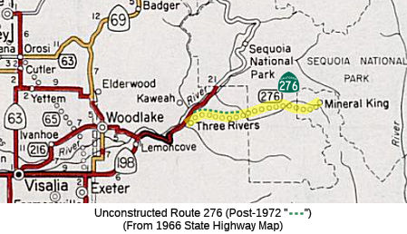 FromRoute 198 near Three Rivers to Oak Grove.
 Post 1964 Signage History
In 1965, Chapter 1372 defined Route 276 as “Route 198 near Three Rivers to Mineral King.”
In 1972, Chapter 1051 changed the terminus: “… to Mineral
King Oak Grove.”
This routing was originally considered by the Legislature as a possible toll road to a proposed recreation complex planned by Disney in the Mineral King area near Sequoia National Park (see http://www.yesterland.com/mineralking.html).This route went all the way to Mineral King, but a 13-mile portion of the highway was later rescinded. Much of that segment is now within Sequoia National Park. It was not in the park at the time of adoption, nor at the time of recission. The proposed routing now ends a little west of the park border.
In December 1965, the U.S. Forest Service awarded a preliminary permit to
Walt Disney Productions giving the company three years to complete a
satisfactory plan for the resort, as a prelude to a permanent 30-year
permit. Disney planned a $35 million year-round resort that was estimated
to attract 2.5 million visitors annually by 1976, the first full year of
operation. The 30-year permit was contingent on an all-weather, 25-mile
highway. The route would go through Sequoia National Park. In 1958,
recognizing that Mineral King had possibly the greatest potential for
winter sports anywhere in the Sierra Nevada mountains, Tulare County asked
the State of California to put in an all-weather road. There was finally
progress in 1965 when the state legislature transferred the county road
into the state highway system in anticipation of a new road. As 1966
progressed, plans for the highway moved ahead. In October, California
Governor Edmund G. “Pat” Brown announced a $3 million Federal
grant toward the $25 million price tag for the road. His next step would
be to apply for a $9 million Federal loan and to seek the balance from the
California legislature. On December 15, 1966, Walt Disney died, but the
Mineral King resort was destined be one of many lasting reminders of his
vision. The U.S. Forest Service approved Walt Disney Productions’
master plan for Mineral King on January 27, 1969. Skiers could expect the
resort to open for the Winter 1973 ski season, when the new road would
also be ready. However, during the years leading up to the approval,
opposition to the Mineral King plans and the all-weather road had been
growing. There was still the issue that the road would have go through
Sequoia National Park. As far back as March 1967, U.S. Secretary of
Interior Stewart Udall expressed opposition to the road, suggesting that
an electric railway or monorail would be better. In May 1972, Walt Disney
Productions announced a major revision to its Mineral King plans,
shrinking the resort to a $15 million resort with 10 ski lifts. With
respect to the road, the biggest change was that access to the resort
would primarily involve a 15-mile cog railway to be financed with a $20
million Tulare County bond and operated by Disney without a profit. The
railway would be nonpolluting, follow the old road, and require a much
narrower right-of-way than the proposed all-weather road. On August 18,
1972, California Gov. Ronald Reagan signed legislation removing a segment
of the all-weather road from the state’s highway system. By October
1973, the resort appeared doomed. With the Sierra Club still using the
legal system to oppose the project, Mineral King was expected to be tied
up in the courts for years. The legality of the proposed cog railway was
called into question. Most importantly, a new law meant the project
required an environmental impact statement. All work stopped until the
completion of that assessment in 1976. In 1977, the U.S. Forest Service
attempted to revive the resort plan, but by then Walt Disney Productions
had walked away from the Mineral King environmental fight in favor of an
entirely different ski resort location on private land at Independence
Lake, north of Lake Tahoe. In 1978, Congress removed the 16,200 acres of
Mineral King from the National Forest and annexed it to Sequoia National
Park. The bill even had language prohibiting downhill ski facilities at
Mineral King.
(Source: Yesterland - Walt Disney's Mineral King, 11/11/2018, focusing on the sections related to the development of the roadway to the resort; MousePlanet 6/10/2019)
 Status
This routing is unconstructed, but a route has been adopted. The portion to Mineral King was adopted in 1967. The portion between Oak Grove and Mineral King was rescinded in 1972. The existing road (Mineral King Road, MTN 375 (a county designation)) is inadequate (narrow, winding, steep grades), and it is not recommended that the state adopt the road.
According to the 2013 Traversable Highways report, Route 198 near Three Rivers to Mineral King added to State Highway System in 1967. Portion of the route between Oak Grove and Mineral King were deleted in 1972. The existing road (Mineral King Road) is inadequate (narrow, winding, steep grades, etc.). The district recommends that the State not adopt this road.
[The "MTN" designation is part of a whole system of county roadways in
the Sierras. They cross county lines and use Caltrans style postmile
markers. For instance, Mineral King Road is MTN 375, and the Great Western
Divide Road, that heads south through Sequoia National Monument, is MTN
107, while MTN 99 gets into Kern County all the way to Route 178. You can
see some of them on Google Maps as road names. There is a USFS map that
references a few of them, though it uses a state highway marker for MTN
107: http://www.fs.usda.gov/detail/sequoia/recreation/?cid=fsbdev3_059482. It appears that almost every little road in the Sierras falls into this
system and has a number, even when they lack milemarkers. You can
sometimes find the numbers on, of all places, Zillow. The MLS entry will
often list the Mountain Road number on some of the more random roads.]
(coatimundi @ AAroads, Topic: ""MTN" Milemarkers",
6/28/2016 and 7/5/2016)
 Statistics
Overall statistics for Route 276:
 Other WWW Links
 Pre-1964 Legislative Route
In 1959, Chapter 1062 defined LRN 276 as “[LRN 78] east of Riverside to [LRN 193] south of Devore”. This was Route 81 from Route 215 E of Riverside to I-15 south of Devore. This routing was proposed, but never constructed. It seems to be approximately Van Buren Blvd in Riverside for the E/W routing, and Sierra Ave for the N/S routing.
© 1996-2020 Daniel P. Faigin.
Maintained by: Daniel P. Faigin
<webmaster@cahighways.org>.
 Route 275
 Route 277