
 California Highways:
Click here for a key to the symbols used. An explanation of acronyms may be found at the bottom of the page.
 Routing
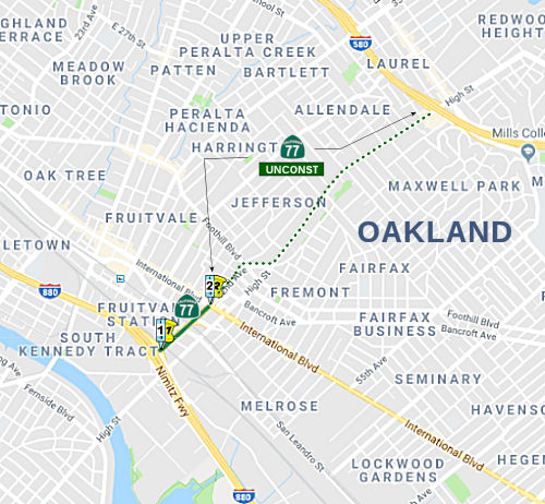 From Route 880 near 42nd Avenue to a connection with Route 580 near High Street in
Oakland.
From Route 880 near 42nd Avenue to a connection with Route 580 near High Street in
Oakland.
 Post 1964 Signage History
As defined in 1963, this segment was defined to be “Route 17 near 42nd Avenue to a connection with Route 580 near High Street in Oakland.”
 Pre 1964 Signage History
Route 77 was not allocated as part of the original signage of state highways in 1934. This segment was a proposed route in 1963, and was LRN 233, defined in 1953, but was renumbered as LRN 235 in 1957.
According to Chris Sampang on AAroads:
(Source: Chris Sampang on AAroads, "Re: CA 77", 3/4/2019)
Looking at Historic Aerials (coordinates 37.76647, -122.21208), the Route 77/Route 17 (now I-880) interchange used to be a full system interchange (likely in anticipation of the eastward extension towards the MacArthur Freeway and to Orinda etc. that never happened). The ramps (and for that matter, the 42nd Avenue freeway itself) first show up on their aerial photos ca. 1958, curiously with the southbound offramp from the Nimitz Freeway/Route 17 coming off on the left side. By 1968, this was replaced with a more standard semi-directional ramp from the right-hand side southbound. The current diamond interchange with Route 77 was installed sometime between 2010 and 2012. In some ways this explains the reason the exit was signed for High Street all these years, even though direct access from southbound I-880 to High Street was only created in 2012: a driver would have to get onto eastbound Route 77 and then take the only offramp to East 12th/High intersection to access High Street itself. The only vestige of the old semi-directional T remaining is the now superfluous ramp from High Street to I-880 north that allows one to skip over the stoplight at Route 77 and Coliseum Way: prior to 2012, the left lane served as an onramp from High to eastbound Route 77, with the flyover being the only access to the northbound Nimitz.
 Status
For a period before 2008, Route 77 between I-880 and post mile 0.45 was signed as Route 185. As of 2008, that segment has been resigned as Route 77. In terms of constructed length, this route is the shortest in the state system, beating Route 283 by 10 feet. There's a nice blog with pictures of this short segment; Tom Fearer also covers the highway in his Feb 2019 Gribblenation Blog California State Route 77; the real "Shortest Signed" State Highway.
The route is unconstructed between Route 185 and Route 580. This was originally signed as Route 185 from Route 185 to I-880 via 42nd Avenue in Oakland; however, as of August 2008, it was signed as Route 77. Note that this signage is of the form of signs on the structures; it appears there are no reassurance markers. It follows the High Street corridor (including the portion that is Route 185) between I-880 and I-580. The constructed portion may be to freeway standards. The portion of High Street may be local traversable highway, not state maintained. As of 2002 the portion on 42nd Avenue was local traversable highway, but the 2008 signage might signal assumption of state maintenance.
The 2013 Traversable Highways report notes, for the portion from E 14th St. in Oakland to the S junction with I-580: the routing is close to 42nd Ave., High St.. There were plans to turn this into the Park
Boulevard Freeway between the Nimitz Freeway (Route 17, later
I-880) and the Warren Freeway (Route 13).
There were plans to turn this into the Park
Boulevard Freeway between the Nimitz Freeway (Route 17, later
I-880) and the Warren Freeway (Route 13).
(Image source: Erica Fisher Flikr Stream)
As of 2008, some work has (re)started on the Isabel Avenue ramp to I-580
Note: 25th Ave does not go far enough north to meet I-580. 35th Ave, however, is the next exit up on I-580 from High St (segment 1) and turns into Redwood Rd (segment 2) at Jordan Rd. So there might be a typo in the route definition.
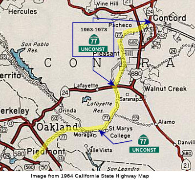 From Route 580 in Oakland to Route 24 near Lafayette.
Post 1964 Signage HistoryIn 1963, this segment was defined to be “Route 580 in Oakland to Route 242 near Concord passing near Lafayette.”
In 1973, Chapter 447 changed the terminus of the segment to be “Route 24 near Lafayette.”
Until 1973, segment (2) ended at Route 242. In 1973, the portion from Route 24 to Route 242 was deleted. At Taylor Boulevard and Pleasant Hill Road in Walnut Creek, there is a Y interchange. As Taylor Boulevard corresponds to the (pre-1973) extension of Route 77 to Route 242, this interchange might have been built in anticipation of the never-built extension. The deleted portion includes Taylor Boulevard (and its interchange with Pleasant Hill Road), Sunvalley Boulevard (between former Route 21 and I-680 at the Sun Valley Mall), and Willow Pass Road to Route 242.
The route would have run through Shepherd Canyon. From 1928, the SN
Railway had passed through Montclair Village and Shepherd Canyon on the
way to Sacramento and Chico. This was an electrified route through the
hills, with a tunnel at Gunn Drive. After the tunnel was sealed off in
1957, Caltrans then proposed a route through the area. Caltrans projected
a daily traffic count of 100,000 vehicles per day by 1990.
(Source: "The Highway That Never Was" (a website
Mark Roberts once had))
Caltrans bought the railroad right-of-way because they saw Shepherd
Canyon as a prime location for Route 77, which they had planned to extend
from Park Boulevard, with a cloverleaf at Route 13, through Shepherd Creek
near Scout Road, then joining the former Sacramento Northern railroad
right of way along Shepherd Canyon Road, and heading out to the Orinda,
Walnut Creek area. Caltrans bought up land in Shepherd Canyon starting in
the 1950’s for Route 77.
(Source: Montclair Railroad Trail - History, captured 8/3/2021)
 Preliminary studies were completed in 1956 covering the location for this future freeway. On December 19, 1956, after various
public meetings and a hearing before the Highway Commission, the last gap
in the route was adopted and declared a freeway. This future facility will
consist of initially four lanes, future six lanes, and starting at the
Mountain Boulevard Freeway in Oakland, will traverse Shepherd Canyon and
tunnel some 1,400 feet through the Oakland hills. It will span the Redwood
Canyon in Contra Costa County and traverse the range of hills easterly
thereof entering and crossing the Moraga Valley just north of the present
town site. It traverses close to St. Mary's College and terminates at a
junction with Route 24 at Pleasant Hill Road. This would have been called
the Shepherd Canyon Freeway.
Preliminary studies were completed in 1956 covering the location for this future freeway. On December 19, 1956, after various
public meetings and a hearing before the Highway Commission, the last gap
in the route was adopted and declared a freeway. This future facility will
consist of initially four lanes, future six lanes, and starting at the
Mountain Boulevard Freeway in Oakland, will traverse Shepherd Canyon and
tunnel some 1,400 feet through the Oakland hills. It will span the Redwood
Canyon in Contra Costa County and traverse the range of hills easterly
thereof entering and crossing the Moraga Valley just north of the present
town site. It traverses close to St. Mary's College and terminates at a
junction with Route 24 at Pleasant Hill Road. This would have been called
the Shepherd Canyon Freeway.
(Image source: Flickr Photostream by Erika Fisher of Unbuilt Oakland)
However, by the 1970’s interest in alternative modes of
transportation drew attention to the fact that CALTRANS had planned Route 77 prior to the advent of BART, and only two miles from then existing
Route 24. In an effort both to encourage alternative modes of
transportation, and to preserve Shepherd Canyon, this was then one of the
largest undeveloped areas in Oakland, residents worked with State Assembly
Member Ken Meade to cancel the Route 77 Plans. This, combined with
extensive opposition, led the plan to be withdrawn in 1972. Subsequently
the Shepherd Canyon Corridor Plan was developed, which shapes the use of
Shepherd Canyon. As part of this plan, Shepherd Canyon Road, then
called upper Park Boulevard, got its current name. Another result
was that 34 acres were set aside for public use and named Shepherd Canyon
Park. Provisions were made for specific parcels of land to be bought from
Caltrans “at cost”, provided they be used for alternative
transportation, such as trails. The old railroad right-of-way is now the
Montclair Railroad Trail, one of Oakland's newest linear parks.
(Source: Montclair Railroad Trail - History, captured 8/3/2021)
 In August 1953, the CHC considered a proposed routing for a segment of LRN 233
(Route 77) through Moraga Valley in Contra Costa County from Bollinger
Canyon Road near St. Mary's to Sign Route 24 near Lafayette. The
recommended route was the Reliez Road location. It runs just N of St.
Mary's College through the Burton Area to a connection with Sign Route 24
at the Pleasant Hill Road intersection.
In August 1953, the CHC considered a proposed routing for a segment of LRN 233
(Route 77) through Moraga Valley in Contra Costa County from Bollinger
Canyon Road near St. Mary's to Sign Route 24 near Lafayette. The
recommended route was the Reliez Road location. It runs just N of St.
Mary's College through the Burton Area to a connection with Sign Route 24
at the Pleasant Hill Road intersection.
(Source: California Highways, Jul/Aug 1955)
Pre 1964 Signage HistoryRoute 77 was not allocated as part of the original signage of state highways in 1934. This segment was a proposed route in 1963, and was part of LRN 233, defined in 1953, but was renumbered as LRN 235 in 1957.
Status This routing is unconstructed from Route 580 to Route 24. The
route is approximately 25th Avenue, Redwood Road, Pinehurst Road, and
Canyon Road to Moraga; St. Mary's Road north to Lafayette. The official
traversable local routing is Park Blvd, Shepherd Canyon Road, and Moraga
Road. The portion from Route 580 to Route 93 was deleted from the Freeway
and Expressway system in 1972, and the adopted freeway route was rescinded
effective 7/18/1974. The adopted freeway routing from Route 93 to Route 24
was rescinded 7/17/1975. The town of Moraga has negotiated to lease a
portion of the state right of way to construct a golf course. Construction
of a conventional highway could be accommodated within the rescinded
alignment. There are no plans to do so.
This routing is unconstructed from Route 580 to Route 24. The
route is approximately 25th Avenue, Redwood Road, Pinehurst Road, and
Canyon Road to Moraga; St. Mary's Road north to Lafayette. The official
traversable local routing is Park Blvd, Shepherd Canyon Road, and Moraga
Road. The portion from Route 580 to Route 93 was deleted from the Freeway
and Expressway system in 1972, and the adopted freeway route was rescinded
effective 7/18/1974. The adopted freeway routing from Route 93 to Route 24
was rescinded 7/17/1975. The town of Moraga has negotiated to lease a
portion of the state right of way to construct a golf course. Construction
of a conventional highway could be accommodated within the rescinded
alignment. There are no plans to do so.
The 2013 Traversable Highways report notes the segment from the North
Junction of Route 580 to Route 24 near Lafayette is unconstructed and
corresponds roughly to Park Blvd., Shepard Canyon Road,
and Moraga Rd.. The portion from Route 580 to Route 93 (4.8 miles) was
deleted from the F&E System in 1972, and the adopted freeway route was
rescinded 7/18/74. The adopted freeway route from Route 93 to Route 24 was
rescinded 7/17/75.
According to one news article, the Gateway Blvd turnoff (now Wilder Road)
just W of the Orinda Crossroads on Route 24 was to be a connection to
Route 77. The exit was built during the construction of the Route 24
freeway. It appears to be the current Wilder Road exit, but it is unclear
how it would connect to the Route 77 freeway in Lost Valley.
(Source: FB Post by Mark Harrigan, 8/3/2021)
 Naming
 Freeway
 [SHC 253.4] From Route 93 westerly of Moraga to Route 24 near
Lafayette. Part (1) is unconstructed from Route 185 to Route 580, and all
of part (2) is unconstructed. Added to the Freeway and Expressway system
in 1959. Note that the portion deleted in 1973 (Route 580 to Route 93) is
explicitly not part of the freeway and expressway system.
 Other WWW Links
 Statistics
Overall statistics for Route 77:
 Pre-1964 Legislative Route
The route that would become LRN 77 was first defined in 1931 by Chapter 82. It was part of segment (l) (“Riverside to San Diego (Inland Route)”) and segment (2) (“Pomona to Temecula”).
Segment l (the Inland route from Riverside to San Diego) was an old established county routing that passed through many settlements and towns in plains and in narrow valleys lying in a semimountainous district between Riverside and San Diego. Riverside and San Diego counties had paved this route in the past, making a serviceable road for light traffic. The state still needed to improved the alignment, and the length of the ultimate State routing would be 20 miles shorter than the existing highway. It was added to the state highway system based on the volume of intercounty and intrastate traffic it carried, and by reason of relief it will afford to existing heavily traveled State roads and as an advantageous component of a comprehensive State system.
Segment 2 (the alternate route from Pomona to Temecula) was viewed as a valuable adjunct in state road systemization, providing a short cut to the Elsinore Lake district and to the Inland route from the territory between Corona and Pomona and the territory north and west of Pomona. The segment provided a convenient approach to the Inland route from Los Angeles and Pasadena vicinity. From extreme points in Los Angeles it offered an alternative passage to San Diego that, although longer than the coast route, avoided restriction to speed on the coast route that is caused by congestion and delays within more numerous cities (a rationale that was not only true in the early 1930s, but is true 80 years later). The proposed segment ran from the western terminus near Pomona to Santa Ana Canyon near Prado (current Route 71 from Route 60 to Route 91), and through Temescal Canyon (present I-15 from Route 91 S to the I-215/I-15 jct) to Lake Elsinore and to Temecula on the inland route (recall that near Elsinore, US 395 did a job from the I-215 routing in Perris across to the I-15 routing). The plan was to use existing road facilities when possible. It was estimated that the route, by 1940, would carry 6450 vehicles on Sunday, and 3100 vehicles on weekdays (24 hr estimates).
In 1935, it was codified into the state highway code as:
“Pomona to San Diego via Temecula”
Note that at this time LRN 77 appears to have run into Vista, not Escondido (see the page on US 395 for details on the routing). This is made clear by the definition of [LRN 196] as being "to [LRN 77] near Vista". LRN 197 started at "[LRN 77] near Escondido", so it appears that as of 1933, the route between Vista and Escondido appears to have been part of LRN 77.
That same year (1935), Chapter 626 added the following as Section 603 with no LRN:
“603. There is hereby added to the state highway system a new route or portion of route from the east city limits of Los Angeles on Valley Boulevard to [LRN 26] near El Monte via Valley Boulevard and Pomona Boulevard”
Note that the 1935 segment only runs as far E as the intersection of Valley and Garvey. It is discontiguous from the rest of LRN 77. .
In 1937, Chapter 841 repealed Section 603, and added the segment to [LRN 77] as segment (a) instead, numbering the 1935 segment as (b).
In 1951, Chapter 1562 extended LRN 196 to terminate at [LRN 77] near Escondido. This implied that by 1951, the portion from Vista to Escondido was no longer LRN 77, and LRN 77 had been rerouted (presumably to the US 395 routing). However, in 1947 Chapter 1233 changed LRN 196 to terminate at Vista, so the rerouting could have been as early as 1947.
In 1953, Chapter 237 changed the definition of (a) to drop the specific routings on Valley Boulevard and Pomona Boulevard.
This route was signed as follows:
This route began at the proposed LRN 167 (eventual I-710) intersection with Valley Blvd (the present I-710 terminus). It ran E along Valley Blvd (US 70 or US 99) to cosigned US 60/US 70/US 99 near El Monte. This was likely signed as a business routing once the Ramona Freeway was completed. It was unsigned Route 212 post 1964.
Between Pomona and Corona, this was and is signed as Route 71.
Between Corona and Temecula, it was originally signed as Route 71 (prior to 1950, this was also US 395); after 1964, it was signed as I-15.
Between Temecula and San Diego, it was originally signed as Route 71, then as US 395, and is present-day I-15.
© 1996-2020 Daniel P. Faigin.
Maintained by: Daniel P. Faigin
<webmaster@cahighways.org>.
 Route 76
 Route 78