
 California Highways:
Click here for a key to the symbols used. An explanation of acronyms may be found at the bottom of the page.
 Routing
 Post 1964 Signage History
 As defined in 1963, this route ran from "Sunset Cliffs Boulevard near Mission Bay southeasterly to Route 5 in San Diego." Chapter 526 later
that year deleted "near Mission Bay southeasterly" from the definition.
The completed Ocean Beach Freeway (California State Route 109) was
dedicated during October 1969. This definition of the route in San Diego
was repealed by Chapter 1216 in 1972, when the segment was transferred to
Route 8.
As defined in 1963, this route ran from "Sunset Cliffs Boulevard near Mission Bay southeasterly to Route 5 in San Diego." Chapter 526 later
that year deleted "near Mission Bay southeasterly" from the definition.
The completed Ocean Beach Freeway (California State Route 109) was
dedicated during October 1969. This definition of the route in San Diego
was repealed by Chapter 1216 in 1972, when the segment was transferred to
Route 8.
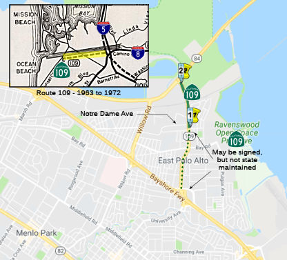
In 1984, Chapter 409 added the current incarnation of Route 109:
“…the vicinity of Notre Dame Avenue in East Palo Alto to Route 84.”
In 1988, Chapter 416 extended the segment from Notre Dame Avenue to US 101, making the definition “Route 84 to Route 101.” The definition explicitly noted that “The department is not responsible for the maintenance or operation of Route 109, except for that segment between Notre Dame Avenue in East Palo Alto and Route 84” (which meant that the extension was signing purposes only).
In 1997, SB 789 (Chapter 277) amended the condition, permitting Caltrans to “maintain and operate the segment of Route 109 within the City of East Palo Alto upon a determination by the department and the city that the segment is in an acceptable state of repair.”
 This route is unconstructed from US 101 to 1 mile north. It
turns into University Ave in E Palo Alto, and runs from Route 84 to Notre
Dame Avenue.
This route is unconstructed from US 101 to 1 mile north. It
turns into University Ave in E Palo Alto, and runs from Route 84 to Notre
Dame Avenue.
The 2013 Traversable Highways report note regarding the segment from US 101 to Notre Dame Avenue: There have been attempts by Caltrans to persuade the city of East Palo Alto to relinquish the portion of University Avenue, between Notre Dame and US 101, to the State as a continuation of Route 109. However, the city remains reluctant to such a proposal. The city of E.Palo Alto has requested the District to terminate the process of determining a traversable highway for Route 109. (November 29, 1989).
The remainder of the route is unsigned.
There are some that speculate that this routing would provide a southern connector to the Dumbarton Bridge. However, any such planning would need to involve the local community planning agencies, as California Streets and Highway Code section 409 states "no study and analysis of any proposed segment of Route 109 shall be conducted without the involvement of the governing body of any city or county through which the segment would pass as an active participant in the study and analysis."
 Pre 1964 Signage History
The present routing is University Avenue between Route 84 and Route 101. This routing was not defined before 1984.
For the 1964-1972 routing, this was LRN 286 (1959). The 1963 state
highway map shows LRN 286 running from Barnett and Pacific Highway along
Midway Drive to Sunset Cliffs. This corresponds to today’s Sports
Arena Drive and W Mission Bay Drive to Sea World Drive. The later 1963
wording change reflected a new adopted alignment of the LRN 286 freeway
west of planned I-5 in San Diego that ran along the southern flank of the
San Diego Flood Control Channel
(Source: Gribblenation Blog (Tom Fearer), "The history of US Route 80 and Interstate 8 in California", June 2024)
Sign Route 109 was not defined as part of the initial state signage of routes in 1934. It is unclear what (if any) route was signed as Sign Route 109 between 1934 and 1964.
 Status
In October 2001, it was reported that a proposal to build a southern
extension to the Dumbarton Bridge through the Palo Alto Baylands is once
again being met with alarm and disdain by Palo Alto city officials. City
officials say a connector to the bridge would also impact traffic on Palo
Alto streets that are too congested already. Other ideas being proposed
include building a second level to the bridge and special on-ramps for
vehicles with two or more passengers. The 84-page conceptual report,
however, only commits one page to the Dumbarton Corridor. There are also
several maps showing various proposals to decrease traffic on the
Dumbarton Bridge. But it is the map showing the extension - which would
run from the bridge across portions of East Palo Alto, Palo Alto and the
Baylands and finally hooking up with Oregon Expressway -- that has city
officials worked up. The council was so worried about these plans they
created a policy to deal with the bridge extension. Policy T-53, in the
city's Comprehensive Plan, states the city would "participate in seeking a
regional solution to improved roadway connection between US 101 and the
Dumbarton Bridge without construction of a southern connection across
environmentally sensitive baylands." Eakins and Council members Vic
Ojakian and Lanie Wheeler, wrote a memo to their colleagues reminding them
of the California Streets and Highway Code section 409, which states "no
study and analysis of any proposed segment of Route 109 shall be conducted
without the involvement of the governing body of any city or county
through which the segment would pass as an active participant in the study
and analysis." "Notwithstanding this state law, the southern connection
has resurfaced in the Bay Crossings with absolutely no consultation with
Palo Alto," the memo states. "This is cause for great concern."
(Source: Palo Alto Weekly, 10/5/2001)
In 2002, it was noted that there have been attempts to persuade the city of Palo Alto to relinquish the portion of University Avenue between Notre Dame and US 101 to the state as a continuation of Route 109. However, the city remains reluctant to such a proposal. Further, the city of E Palo Alto has requested the state to terminate the process of determining a traversable local highway for Route 109.
 Interstate Submissions
In April 1958, it appears that the designation I-109 was proposed for the route that is now I-280. This was part of the first attempt to assign 3-digit interstates n California. The number was rejected by AASHTO.
 Other WWW Links
 Statistics
Overall statistics for Route 109:
 Pre-1964 Legislative Route
In 1933, Chapter 767 defined the route from “[LRN 4] at Modesto Northerly to [LRN 13] between Salida and Riverbank” as part of the state highway system. In 1935, this definition was codified into the highway code as LRN 109.
In 1959, Chapter 1062 changed the origin of the route to “[LRN 238] near Crows Landing”.
This route ran from I-5 near Crows Landing to Route 108 (the present-day Route 219/Route 108 junction) between Salida and Riverbank. This is the first segment of present-day Route 108.
© 1996-2024 Daniel P. Faigin.
Maintained by: Daniel P. Faigin
<webmaster@cahighways.org>.
 From Route
  Route 108
 Route 110