
 California Highways:
Click here for a key to the symbols used. An explanation of acronyms may be found at the bottom of the page.
 Routing
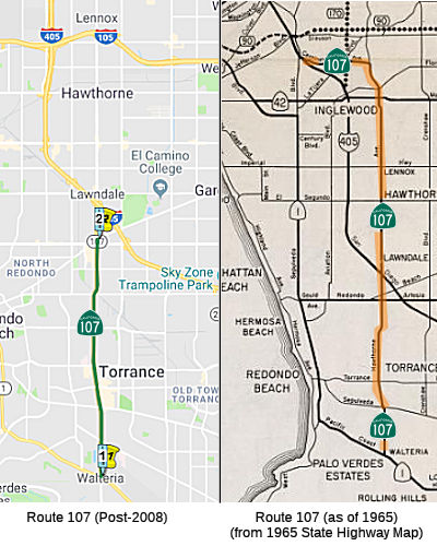 From Route 1
in Torrance to the southern city limits of Lawndale.
From Route 1
in Torrance to the southern city limits of Lawndale.
The relinquished former portion of Route 107 in the City of Lawndale is not a state highway and is not eligible for adoption [as a state highway].
(a) The commission may relinquish to the City of Torrance the portion of Route 107 that is located within the city limits of the city, upon terms and conditions the commission finds to be in the best interests of the state. (b) A relinquishment under this section shall become effective immediately following the recordation by the county recorder of the relinquishment resolution containing the commission's approval of the terms and conditions of the relinquishment. (c) On and after the effective date of the relinquishment, both of the following shall occur: (1) The portion of Route 107 relinquished under this section shall cease to be a state highway. (2) The portion of Route 107 relinquished under this section may not be considered for future adoption under Section 81. (d) The city shall ensure the continuity of traffic flow on the relinquished portion of Route 107, including, but not limited to, any traffic signal progression. (e) For the portion of Route 107 that is relinquished, the city shall maintain within its jurisdiction signs directing motorists to the continuation of Route 107.
(a) The commission may relinquish to the City of Redondo Beach the portion of Route 107 that is located within the city limits of the city, upon terms and conditions the commission finds to be in the best interests of the state. (b) A relinquishment under this section shall become effective immediately following the recordation by the county recorder of the relinquishment resolution containing the commission’s approval of the terms and conditions of the relinquishment. (c) On and after the effective date of the relinquishment, all of the following shall occur: (1) The portion of Route 107 relinquished under this section shall cease to be a state highway. (2) The portion of Route 107 relinquished under this section may not be considered for future adoption under Section 81. (3) The city shall ensure the continuity of traffic flow on the relinquished portion of Route 107, including, but not limited to, any traffic signal progression. (4) For the portion of Route 107 that is relinquished, the city shall maintain within its jurisdiction signs directing motorists to the continuation of Route 107.
 Post 1964 Signage History
In 1963, this route was defined as the route from "Route 1 near Torrance to Route 405 near Culver City." The route continued when Hawthorne changed to La Brea, and then followed Centinela to end at Route 405 in Culver City (before the interstate, the routing ended at Sepulveda Blvd, Route 7).
In 1965, Chapter 1372 changed the terminus of the route to "Route 405
near Lawndale". The Lawndale portion north of I-405 (from Rosecrans to
160th St., 07-LA-107 5.5/6.7) was relinquished by the CHC on 12/13/1967.
The resolution says it was due to a legislative enactment effective
1/1/1968, but the bill changing the route was effective 1/1/1966.
(Source: Relinquishment information via email from Jim White of
Caltrans, 4/8/2023)
In 1998, the definition was updated to allow the portion of Route 107 in
Lawndale to be relinquished if the city and state agree to do so. This
relinquishment was authorized by AB 2132, Chapter 877, signed September
26, 1998. However, the definition remained "From Route 1 near Torrance to
Route 405 near Lawndale". The Lawndale portion south of I-405 (from 160th
St to Redondo Beach Blvd, 07-LA-107 4.8/5.5) was relinquished by the CTC
on 7/15/1999.
(Source: Relinquishment information via email from Jim White of
Caltrans, 4/8/2023)
In 2003, the legislative definition was updated (AB 1717, Chapter 525, 9/25/2003) to eliminate the portion in Lawndale.
In 2008, Chapter 639 (AB 2326, 9/30/2008) authorized the relinquishment of the portion in the city of Torrance:
(a) The commission may relinquish to the City of Torrance the portion of Route 107 that is located within the city limits of the city, upon terms and conditions the commission finds to be in the best interests of the state.
(b) A relinquishment under this section shall become effective immediately following the recordation by the county recorder of the relinquishment resolution containing the commission's approval of the terms and conditions of the relinquishment.
(c) On and after the effective date of the relinquishment, both of the following shall occur: (1) The portion of Route 107 relinquished under this section shall cease to be a state highway. (2) The portion of Route 107 relinquished under this section may not be considered for future adoption under Section 81.
(d) The city shall ensure the continuity of traffic flow on the relinquished portion of Route 107, including, but not limited to, any traffic signal progression.
(e) For the portion of Route 107 that is relinquished, the city shall maintain within its jurisdiction signs directing motorists to the continuation of Route 107.
In 2022, Chapter 281 (AB 2254, 9/13/2022) authorized the relinquishment of the portion in Redondo Beach:
(a) The commission may relinquish to the City of Redondo Beach the portion of Route 107 that is located within the city limits of the city, upon terms and conditions the commission finds to be in the best interests of the state.
(b) A relinquishment under this section shall become effective immediately following the recordation by the county recorder of the relinquishment resolution containing the commission’s approval of the terms and conditions of the relinquishment.
(c) On and after the effective date of the relinquishment, all of the following shall occur:
(1) The portion of Route 107 relinquished under this section shall cease to be a state highway.
(2) The portion of Route 107 relinquished under this section may not be considered for future adoption under Section 81.
(3) The city shall ensure the continuity of traffic flow on the relinquished portion of Route 107, including, but not limited to, any traffic signal progression.
(4) For the portion of Route 107 that is relinquished, the city shall maintain within its jurisdiction signs directing motorists to the continuation of Route 107.
 Planned as freeway in 1965; never upgraded. The freeway planning was an offshoot of attempting
to build a Route 1 freeway. While the Route 1 alignment through Long Beach
and Wilmington was pretty much due E-W, at its western end it curved north
to avoid Palos Verdes, threading the needle between PCH and the massive
Mobil refinery between Western Ave. (Route 213) and Crenshaw Blvd. in
Torrance. Rather than draw the ire of coastal residents in Redondo Beach,
the freeway facility left the Route 1 corridor east of Hawthorne Blvd. and
became a freeway segment of Route 107 north to a terminus at I-405 near
Lawndale. The original plan for the route would have had Route 107 (the Torrance
Freeway) curve south and east through the South Bay. There were
originally four color-coded proposed routes that were presented on July
15, 1968. All the proposed routes—red, blue, green and
yellow—began at I-405 near Compton Boulevard (now Marine Avenue) and
eventually ended in the vicinity of Five Points in Harbor City. At that
point, Route 107 would link up with the Pacific Coast Freeway (Route 1).
The routes were:
Planned as freeway in 1965; never upgraded. The freeway planning was an offshoot of attempting
to build a Route 1 freeway. While the Route 1 alignment through Long Beach
and Wilmington was pretty much due E-W, at its western end it curved north
to avoid Palos Verdes, threading the needle between PCH and the massive
Mobil refinery between Western Ave. (Route 213) and Crenshaw Blvd. in
Torrance. Rather than draw the ire of coastal residents in Redondo Beach,
the freeway facility left the Route 1 corridor east of Hawthorne Blvd. and
became a freeway segment of Route 107 north to a terminus at I-405 near
Lawndale. The original plan for the route would have had Route 107 (the Torrance
Freeway) curve south and east through the South Bay. There were
originally four color-coded proposed routes that were presented on July
15, 1968. All the proposed routes—red, blue, green and
yellow—began at I-405 near Compton Boulevard (now Marine Avenue) and
eventually ended in the vicinity of Five Points in Harbor City. At that
point, Route 107 would link up with the Pacific Coast Freeway (Route 1).
The routes were:
(Source: Note: Some information in the above is
from Sparker @ AAroads, 8/14/2016; the rest is from EIRs on construction of Route 107; Image source: Daily Breeze, 11/24/2018)
Planners also included three shorter segments labeled A, B and C that could be used in combination with the colored routes to create additional route options.
All of the routes would have traveled through Lomita, and this was their
demise. The Department of Highways estimated that more than 1,100
single-family residences, 18 to 64 commercial structures and one to eight
industrial plants could be affected. Officials debated the various
options, but in the end, proponents of a "no build" option found support
in the Lomita City Council, which unanimously opposed all the routes.
Other cities felt differently: Torrance voted in favor of a slightly
modified red route, a choice later endorsed by Redondo Beach and Rolling
Hills Estates. Yet Lomita's refusal was the killer, as the State Highway
Code forbids the state to close any city streets for a freeway without the
city's permission. At one point, Lomita officials suggested using an
abandoned Pacific Electric line near Normandie Avenue (creating an option
called the Orange Route.
This segment would have followed the abandoned line and swing through
southeast Torrance before connecting to the rest of the proposed freeway.
However, this outraged Torrance residents and city officials, who
unanimously opposed the change (plus Lomita's didn't like it either).
Redondo Beach, Torrance and Rolling Hills Estates officials eventually
joined Lomita against the freeway. By 1972, the freeway was all but
officially dead.
(See also: Daily Breeze, 11/24/2018)
According to Scott Parker, while the Lomita-Torrance segment of the
Pacific Coast/Hawthorne freeway system was rife with controversy, it was
the Route 1 segment east of there traveling through Wilmington and Long
Beach that attracted the most attention as well as negative sentiments and
subsequent comments, since it tore up a number of old-stock houses and
commercial structures by passing through an arguably historic district
immediately north of downtown Long Beach (more or less along 10th Street).
Unlike the Torrance section to the west, this one had been formally
adopted, with the ROW "set in stone", since the early '60's. Its eastern
end segued onto Route 22 on East 7th Street, which fed directly east into
the I-405/I-605 interchange. By the beginning of 1975, Caltrans had
acquired about half of the required ROW west as far as the west limits of
the adopted section, at Western Ave. in Harbor City; construction, slated
to start in late 1978 or early 1979, was to proceed east to west. With the
advent of the decidedly anti-freeway Gianturco regime at Caltrans at the
beginning of 1975, a review of urban freeway mileage -- whether formally
adopted or simply future corridor concepts -- was underway as the
beginning of a major "purge". The Long Beach section, since even within
its advanced planning stages was the subject of localized protests against
its development, stood out -- and became the well-publicized "poster
child" for the program of eliminating as much unbuilt urban freeway
mileage as possible. So by mid-1976 the plans had been shelved, the
adoption rescinded, and the ROW put up for sale; the last state-owned
property had been disposed of by 1980. Of course the Torrance extension,
which had been on indefinite hold since 1974, was itself formally
rescinded at the same time -- so the full Route 1/Route 107 "loop" from
the east side of Long Beach to I-405 in the Lawndale vicinity was off the
books after that. And with the Coastal Commission having, after 1977,
effective "veto power" over projects within the shoreline watershed (which
decidedly included the territory traversed by that loop), the entire
notion of a freeway approximating that original concept would be D.O.A.
from that point forward.
(Source: Scott Parker on AARoads ("Re: The Torrance Freeway would have changed the face of the South Bay"), 7/19/2019)
The Route 107 freeway was officially deleted in 1978.
 Pre 1964 Signage History
Route 107 was not defined in the initial set of signed state routes in 1934. It was part of LRN 164, defined in 1933 as "LRN 60 at Torrance via Hawthorne Avenue to Mines Field-San Fernando Road". LRN 60 was the Coast Route (Pacific Coast Highway); "Mines Field-San Fernando Road" is what is today known as Sepulveda Blvd, which at the time ended at the junction with Centinela. Before 1938 the entire routing was the southern end of what was then signed as Route 7, so one might surmise the the number 107 was somehow related. Route 107, signed as such, first appears in the 1938 state highway map.
By 1935, the definition of LRN 164 had changed to "LRN 60 at Torrance to LRN 158 via Hawthorne Avenue". LRN 158 was Sepulveda Blvd from San Fernando to the Airport, although the portion S of Centinela was unconstructed. When sign routes were announced in 1934, signed Route 7 followed the entirety of LRN 158 to LRN 164, and then along LRN 164 to Route 3/LRN 60 (US 101A, Pacific Coast Highway).
In 1936, a contract was awarded to construct LRN 158/Sepulveda Boulevard
from LRN 164 at Centinela Avenue south to US Route 101A/LRN 60 at Lincoln
Avenue -- bringing it to the airport. By 1938, LRN 158/Sepulveda Boulevard
was constructed south of LRN 164/Centinela Avenue to US 101A/LRN 60 near
the grounds of Mines Field (Los Angeles Municipal Airport). A small
segment of LRN 158/Sepulveda Boulevard north of LRN 164/Centinela Avenue
in the Culver City area was unconstructed. By 1938, signed Route 7
ws realigned following LRN 158/Sepulveda Boulevard south to a terminus at
US 101A/LRN 60, and LRN 164 was shown as signed Route 107. The
entirety of Route 107/LRN 164 was added to the Freeways & Expressway
System when it was created during 1959.
(Source: Gribblenation Blog (Tom Fearer), "California State Route 107", May 2022)
 Status
In late March 2007, the City of Torrance indicated its desire to take
over the segment of this route within its city limits. Specifically, the
Torrance City Council voted unanimously to send a letter indicating its
interest in having the state Department of Transportation relinquish
control of the 5-mile segment of Pacific Coast Highway and 6-mile stretch
of Hawthorne Boulevard within Torrance limits. Sending the letter is a
precursor to an estimate the city is required to provide to Caltrans of
the cost of bringing each road up to a "state of good repair." City staff
members believe it will cost $25M to $30M for each road, which the state
would provide to the city in the form of a one-time payment. Bringing the
route under city control will allow the city to improve the timing of
signal lights to improve traffic flow and reduce the bureaucracy needed to
upgrade the roads.
(Source: Daily Breeze, 3/29/2007)
The intersection with Route 1 in Torrance (LA 0.000) is being reconstructed under TCRP Project #46. This project was to reconstruct the intersection of Hawthorne Boulevard (Route 107) and Pacific Coast Highway (Route 1) by adding turn pockets. The cost to complete PA&ED was significantly underestimated in the original application, and additional TCRP funds are required to complete the phase. With R/W estimated to be over $26,000,000, the overall project cost has exceeded the total TCRP funds available. Per the September 2006 CTC Agenda, until such time as the City of Torrance and the Department can identify additional funds to complete PS&E, R/W, and Construction, those phases have been put on hold. In order to complete PA&ED and closeout the phase, an additional $467,000 of TCRP funds is required. Note: According to the Daily Breeze on 3/29/2007, this project was originally began by the City of Torrance, and was to consist of a right turn lane from northbound Hawthorne Boulevard to eastbound Pacific Coast Highway. The project was estimated to cost about $2 million. Caltrans took over the project, changed the scope of the improvements to include the entire intersection, studied and designed it at a cost of $2 million, and concluded that upgrading the entire intersection would cost $15 million.
In October 2021, the CTC approved the following SHOPP amendment:
07-LA-405 17.6. PPNO 07-5490; ProjID 0718000307; EA 35390. Route 107 In
Lawndale, at Route 107 at Hawthorne Undercrossing Bridge No.53-1231.
Seismic retrofit of bridge and upgrade facilities to Americans with
Disabilities Act (ADA) standards. Note: The previous strategy of
constructing cast-in-place reinforced concrete panels and dowels in front
of pier walls has been changed to a strategy of using columns with carbon
fiber reinforced polymer casings. This change reduces both
construction capital and support. Reduce R/W capital because less
positive utility location work is needed under the new strategy.
Allocation changes ($1000s): Con Sup $2,151 ⇒ $1,926; R/W Cap
$47 ⇒ $43; Const Cap $4,681 ⇒ $3,536; Total $9,997 ⇒
$8,623.
(Source: October 2021 CTC Agenda, Agenda Item
2.1a.(1d) #6)
 Freeway
[SHC 253.1] Entire route. Added to the Freeway and Expressway system in 1959.
 Naming
The segment from Route 1 to Route 405 (in anticipation of freeway construction, which never materialized) was named the "Torrance Freeway". It was named by Assembly Concurrent Resolution 63, Chapter 171, in 1968. Torrance refers to the City of Torrance, which was planned in 1911 as a model city and named by the owner of the land, Jared S. Torrance.
Prior to 1968, this route was named the "Hawthorne Freeway", by location. It traverses the city of Hawthorne, which was named, about 1906, for the great American novelist.
 Other WWW Links
 Statistics
Overall statistics for Route 107:
 Pre-1964 Legislative Route
In 1933, Chapter 767 added the following segments to the state highway system:
In 1935, LRN 107 was added to the state highway system with the following routing:
Later in 1935, Chapter 427 amended the last segment to be "[LRN 68] near Redwood City to [LRN 55] via Woodside."
In 1949, Chapter 1044 changed the definition to include the Dumbarton Bridge, making the terminus of segment (b) "[LRN 68] near Palo Alto". This was part of an act that authorized the acquisition and operation of the Dumbarton Bridge, and that they shall be operated as state highways. This change became effective once the California Toll Bridge Authority acquired the bridge.
 In 1959, Chapter 1062 combined and extended (b) and (c). It then swapped the
two segments, making (a) "[LRN 56] to a point near Sunol, on the highway
described in subdivision (b) of this section", with (b) going from Walnut
Creek. to Scotts Corners.
In 1959, Chapter 1062 combined and extended (b) and (c). It then swapped the
two segments, making (a) "[LRN 56] to a point near Sunol, on the highway
described in subdivision (b) of this section", with (b) going from Walnut
Creek. to Scotts Corners.
This route was signed as follows:
This is all part of present-day Route 84, except that the portion between I-280 and US 101 is Route 114. It includes the Dumbarton Bridge.
© 1996-2020 Daniel P. Faigin.
Maintained by: Daniel P. Faigin
<webmaster@cahighways.org>.
 Route 106
 Route 108