
 California Highways:
Click here for a key to the symbols used. An explanation of acronyms may be found at the bottom of the page.
 Routing
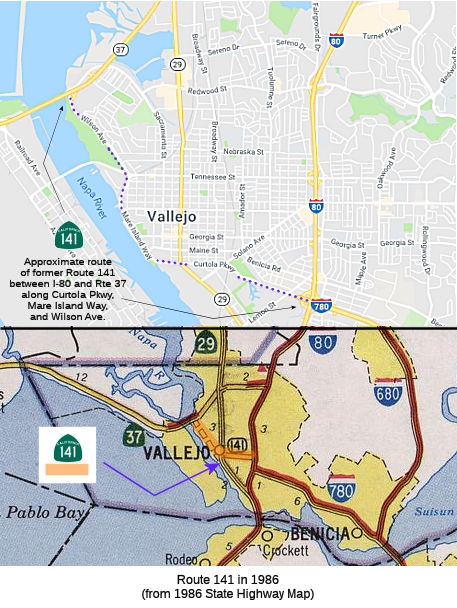 No current routing.
 Post 1964 Signage History
 ▸In 1963, this route was defined as "Route 80 to Route 29 in
Vallejo."
Directly west of I-80 the path of I-780 becomes non-state maintained
Curtola Parkway. During the 1964 State Highway renumbering Route 141 was
assigned to the former portion of LRN 74 between I-80 and Route 29. At the
time Route 141 appears to have used Lemon Street, Benicia Road and Maine
Street to connect from I-80/I-680 to Route 29 (Sonoma Blvd).
(Source: Gribblenation Blog (Tom Fearer): Interstate 780 and path of California State Route 141, 2/22/2019)
By 1966 the implied path of CA 141 to CA 37 appears on the State Highway Map.
▸In 1965, Chapter 1371 reworded the definition to be "the westerly extension of Route 680 from Route 80 into Vallejo."
At some point in time, the freeway corridor of Route 141 came to be known
as the Waterfront Freeway. The corridor of the Waterfront
Freeway was reported as being scaled back to a boulevard in the April 25,
1974, Vallejo Times Herald. The August 20, 1974, Vallejo Times
Herald reported the city of Vallejo voted to speed up construction of
Waterfront Boulevard. Waterfront Boulevard was constructed as what
is now known as Mare Island Way.
(Source: Gribblenation Blog (Tom Fearer), "Former California State Route 141", 4/20/2023)
▸In 1975, Chapter 1078 extended the route: "into Vallejo
to Route 37." Route 37 is former Sign Route 48.
▸In 1976, Chapter 1354 changed "Route 680" to "Route 780". This tied to the changes in I-680 and Route 21 that year.
 In 1976, it was reported that public hearings were being held on Route 141, which had been
designated the Waterfront Freeway Route. There were plans for a full
freeway, but those were rescinded in favor of a boulevard-type street from
the end of I-780 at Lemon Street to a connection with a new waterfront
boulevard authorized along the route of Mare Island Way. There were four
alternate routes under consideration.
In 1976, it was reported that public hearings were being held on Route 141, which had been
designated the Waterfront Freeway Route. There were plans for a full
freeway, but those were rescinded in favor of a boulevard-type street from
the end of I-780 at Lemon Street to a connection with a new waterfront
boulevard authorized along the route of Mare Island Way. There were four
alternate routes under consideration.
(Source: Times Herald Vallejo, 2/29/1976 via Joel Windmiller,
1/29/2023)
▸In 1988, SB 177, Chapter 106 deleted the route.
This route approximates the current Curtola Parkway and Mare Island
Parkway between Route 37 and I-80/I-780. Relinquishment may have occured
as a condition of the construction of Mare Island Parkway. The Curtola
Parkway's construction began in 1988 as well, with the facility opening in
late 1989. It does not appear as if the parkway was a Caltrans project.
Apparently Caltrans ceded the ROW for the cancelled Route 141 freeway to
the City of Vallejo, which constructed the parkway itself; it was part of
an overall project to upgrade the city's waterfront (including the S.F.
ferry terminal). Since there was a direct extension of the parkway from
Sonoma Blvd/Route 29 west to that waterfront, the parkway was intended to
directly convey traffic -- and potential tourists -- from both I-780 and
I-80 to the revamped waterfront -- as well as provide improved access from
Benicia and environs to the ferry terminal.
(Source for information on the Curtola Parkway: Scott Parker (SParker) on AAroads, "Re: Interstate 780 and California State Route 141", 2/23/2019)
 Pre 1964 Signage History
The original (1963) route was originally part of LRN 74.
The route that was to become LRN 74 was first defined in 1931 by Chapter 82 as the route from Vallejo to [LRN 8] (although the April 1931 CHPW describes the route as being from LRN 8 near Cordelia via American Canyon to LRN 14). This eventually became part of signed Route 29. The situation in 1931 was that traffic between the Sacramento Valley and the bay cities could not find the direct and most advantageous passage from LRN 8 to LRN 14 over connected state highways. LRN 7 (roughly today's I-580) was available via the Martinez Ferry, but a better road and bridge facility implied almost exclusive use of a county highway from the Napa Wye to the Carquinez Straits. It was felt that a state route should be established to service the through traffic which was forced onto county roads. The route proposed for LRN 74 was a favorable route from Cordelia south to LRN 14 by way of American Canyon. This route was 5 miles shorter than the route using the Napa Wye and 9 miles shorter than the routing through Martinez. The new route avoided the disadvantageous passage over steep intersecting streets in Vallejo. It was considered appropriate to add it to the state highway system as it would serve a very large volume of state traffic now carried over a county highway.
LRN 74 was extended from Vallejo beginning at Sonoma Boulevard (US 40/Route 29) via Maine Street and Benicia Road east to Benicia. From
Benicia, LRN 74 continued north to Cordelia via what had been the original
alignment of US 40 on LRN 7.
(Source: Gribblenation Blog (Tom Fearer), "Former California State Route 141", 4/20/2023)
In 1935, it was codified into the highway code as "Vallejo to [LRN 8]", but was quickly amended by Chapter 274 to be the following:
"A point on [LRN 8] near the Napa Y to Cordelia via Vallejo and Benecia"
In 1947 during the 1st executive session, Chapter 13 added a branch to the ferry in Benicia: "...including a connection from Vallejo to [LRN 7] near the Carquinez Bridge."
In 1953, Chapter 1737 made the clause about the Benecia Ferry contingent on the acquisition by the Department of Public Works of the ferry system operated across the Carquinez Straights between the cities of Benecia and Martinez. This was done because the city of Martinez was about to close down the ferry system across the straights, and it was necessary to keep the ferry in operation to serve numerous refineries, chemical plants, steel companies, and other industries necessary for national defense, workers commuting both to and from such industries, and the extremely important Benecia Arsenal.
In 1959, Chapter 1062 extended the route to begin at [LRN 6] near Napa, and removed the contingency.
This route was signed as Route 29 between Vallejo and Napa, and was defined in 1931.
The segment between Vallejo and Benicia appears not to have been signed as a state route (at least on the state highway maps), and was originally Route 141 in the post 1964 renumbering. The portion from US 40 (now I- 80) to Benicia was originally I- 680, and is now I-780.
The segment between Sign Route 29 and Benicia first appeared on state
maps in 1938.
(Source: Gribblenation Blog (Tom Fearer), "Former California State Route 141", 4/20/2023)
Scott Parker (SParker) on AAroads noted the following:
(Source: Scott Parker (SParker) on AAroads, "Re: Interstate 780 and California State Route 141", 2/22/2019)
LRN 74 was unusual in that it was U-shaped, consisting of Pre-1964 Route 29 from Pre-1964 Route 12/LRN 8 at Napa Junction south to the intersection of present Route 29 and Maine Street in Vallejo; there it split into the main stem which extended east on Maine to Benicia-Vallejo Road, then utilized that into Benicia; the surface street was never signed as a pre-1964 route prior to 1964. However, Pre-1964 Route 29 south from the intersection in Vallejo to I-80 just north of the Carquinez Bridge(s) was a LRN 74 spur. Once in Benicia, it spawned another spur to the ferry terminal to Martinez, across the Carquinez Strait; this, and the remainder of LRN 74 north to Cordelia Junction (old US 40/LRN 7) were signed as part of Pre-1964 Route 21, which utilized the ferry to get to its southern section in Contra Costa and Alameda counties. By late 1962 the initial section of I-680 from the present I-80/780 interchange in Vallejo east toward Benicia had opened, and LRN 74 was rerouted over that freeway; two years later Route 141 subsumed the section of LRN 74 between Route 29 and I-80, although the east end had been shunted south to the NW end of (then) I-680, which entailed about a 2-3 block right-angle shunt south of Benicia-Vallejo Road. Route 141 received signage circa 1968; this involved trailblazers and an initial reassurance shield on EB Maine, directional changes where the route shifted to Benicia-Vallejo Road, and I-680 (later 780) trailblazers at the shunt down to the end of that freeway about a quarter-mile west of I-80. The sole Route 141 indication WB was at the stub-end of the I-680/780 freeway, which was originally planned to continue on to Route 37 via Mare Island. That freeway routing was deleted from the system in 1976 along with a batch of others statewide as part of then-Caltrans director Adriana Gianturco's orders to slash as much urban proposed freeway mileage as possible (with legislative concurrence). Signage remained on the surface segment of Route 141 until that too was relinquished circa 1982. One "straggler" Route 141 sign remained at the Maine/B-V Road intersection until about 1989.
In June 1961, I-680/LRN 74 was completed between Vallejo and Benicia,
from US 40/I-80. The opening of I-680 between Vallejo and Benicia required
LRN 74 to jog south from Benicia Road via Lemon Street to reach the
beginning of the new freeway. In 1962, a 4.2 mi freeway corridor was
adopted west from the terminus of I-680 at Lemon Street to Sign Route 48
through Vallejo. As part of the 1964 renumbering, LRN 74 west from
I-80 to Sign Route 29 was designed as Route 141. Route 141 was
aligned over Maine Street, Benicia Road and Lemon Street within
Vallejo.
(Source: Gribblenation Blog (Tom Fearer), "Former California State Route 141", 4/20/2023)
Sign Route 141 was not defined as part of the initial state signage of routes in 1934. It is unclear what (if any) route was signed as Sign Route 141 between 1934 and 1964.
 Naming
 Other WWW Links
 Pre-1964 Legislative Route
In 1933, Chapter 767 defined the route from "[LRN 4] via Brundage Lane and Oak Street to [LRN 4] near Beardsley School" as a state highway route. In 1935, it was added to the highway code as LRN 141 with that routing:
In 1963, Chapter 1698 changed the routing to be "[LRN 4] via Brundage
Lane, Union Avenue and Golden State Avenue and Oak Street
to [LRN 4] near Bakersfield Beardsley School",
although this change didn't take effect due to the 1963 Renumbering
(Chapter 385); instead that routing was assigned to Route 204. Brundage
Lane was deleted from the definition of Route 204 upon the completion of
the Route 58 freeway in Bakersfield in 1978.
The original routing for LRN 141 is in Bakersfield, and is no longer part of the state highway system, although Brundage Lane roughly parallels present-day Route 58, and Oak Street parallels the post-1964 routing of Route 99. This appears to be the planned rerouting for US 466 to bypass downtown Bakersfield (back when LRN 4/US 99 (and US 399) was on the Route 204/Business Route 99 alignment) back in 1933; this rerouting only occured in the 1960s however with the construction of the freeways which are now Route 58 and Route 58/Route 99 (explaining why the definition of the route is from LRN 4 to LRN 4: from Brundage at Route 204 to the current Route 99/Route 58/Route 178 interchange at Rosedale Highway/24th Street, where Oak Street ends). Looking at the bridge log, the Route 204/Business Route 99 (former LRN 4) freeway in downtown Bakersfield between LRN 141's two termini (current Route 58 and Route 99) was built in stages: the first section, the Union Avenue Y, was finished in 1957, followed by the Truxtun Avenue crossing in 1959. Most of the section north of L Street and the Chester Avenue traffic circle was also built in 1957; so the construction of the LRN 141 (99/58) freeways occured only once CalTrans decided that the old downtown bypass was more suitable for the through routes. The interchanges connecting Business Route 99 with Route 99 were built in 1962 and 1963, as part of the Bakersfield bypass. Thus by 1964, former LRN 141 had been upgraded to freeway between Brundage Lane and Rosedale Highway; however, the portion from Union Avenue (Route 204/Business Route 99) west to Route 99 would not be built until 1976, at which point Route 58 was moved off of former US 466/LRN 58 (Edison Highway) and onto the new freeway, which is part of the Bakersfield-Tehachapi Highway.
The routing of LRN 141 appears to have always been intended to meet the
realigned routing of US 99 and LRN 4 through downtown Bakersfield.
The Division of Highways in 1934 announced that the bypass route of
US 99/LRN 4 around downtown Bakersfield via Golden State Avenue opened to
traffic as of 6/2/1934. The new alignment of US 99/LRN 4 on Golden
State Avenue split northwest from Union Avenue at 20th Street. US 99/LRN 4 on Golden State Avenue crossed through its former alignment at
Chester Avenue via the new 320-foot diameter Garces Traffic Circle (which
had been completed in 1933). Chester Avenue north of Golden State
Avenue would be incorporated into LRN 142. By 1935, LRN 141 appears a
western bypass loop of US 99/LRN 4 in Bakersfield. LRN 141 followed
Pierce Road, overlapping Sign Route 178/LRN 58 briefly on Rosedale
Highway, Oak Street and Brundage Lane. In 1959, the Division
of Highways notes right-of-way for a relocated US 99 freeway through
Bakersfield was in the process of being obtained. The Both the
planned US 99 and US 466 freeways are shown to bypass downtown Bakersfield
via the general corridor of LRN 141. However, by 1951, the Bakersfield
Bypass appears as part of a planned realignment of LRN 4 as opposed to LRN 141. By 1962, the US 466 freeway appears as part of a planned
realignment of LRN 58 south of Brundage Lane as opposed to LRN 141.
(Source: Gribblenation Blog (Tom Fearer), "Pre-1964 Legislative Route Number 141 in Bakersfield", 1/2023)
In 1963, US 99/LRN 4 moved to the completed West Bakersfield
Freeway. The West Bakersfield Freeway saw the relinquishment of
Union Avenue south of Brundage Lane/LRN 141 which truncated US 399 out of
Bakersfield to US 99 at Pumpkin Center on Taft Highway. US 466 was
left as the standalone mainline route on Golden State Avenue. The US 99 Business Route followed the former alignment of US 99 on Union Avenue
and multiplexed US 466 on Golden State Avenue.
(Source: Gribblenation Blog (Tom Fearer), "Pre-1964 Legislative Route Number 141 in Bakersfield", 1/2023)
Until 1963, LRN 141 was a bypass of Bakersfield at which time it was to be swapped with LRN 4, but Brundage Lane remained part of it because the new LRN 4 went to its west end. Of course, this 1963 change was obviated by the 1963 renumbering, which put Route 58 and Route 99 on the LRN 141 bypass, with Route 204 taking the original Route 99 (LRN 4) routing.
© 1996-2020 Daniel P. Faigin.
Maintained by: Daniel P. Faigin
<webmaster@cahighways.org>.
 Route 140
 Route 142