
 California Highways:
Click here for a key to the symbols used. An explanation of acronyms may be found at the bottom of the page.
 Routing
 Post 1964 Signage History
As defined in 1963, Route 133 ran from "Route 1 near Laguna Beach to Route 5 near Irvine.".
In 1966, it was announced that the expansion of Route 133 to four lanes
from I-5 south tying into the planned I-405 interchange and Laguna Canyon
Road was budgeted for the 1967-68 Fiscal Year. By 1969, the completed
Route 133/I-405 interchange and four lane alignment of Route 133 between
I-5 south to I-405 was showing on state highway maps.
(Source: Gribblenation Blog (Tom Fearer), "California State Route 133", 1/7/2022)
The first segment of the Laguna Freeway opened in 1970.
 During 1986, the Transportation Corridors Agencies (TCA) of Orange County were created. Corridors
governed by the TCA included: the Eastern Transportation Corridor,
Foothill Transportation Corridor and San Joaquin Hills Transportation
Corridor. 1987 Legislative Chapter 1413 allowed for transportation
corridors to be constructed by way of toll funds. The Eastern
Transportation Corridor was assigned as Route 231, and was originally
defined as "Route 5 near the border of the Cities of Tustin and Irvine to
Route 91." At this point, the TCA routes were Route 231 (I-5 near
Tustin/Irvine to Route 91 roughly along Jamboree Road) and Route 241 (I-5
near San Clemente to Route 231 near Santiago Canyon Road (County Sign Route S18) near
Irvine Lake). Route 133 was not part of the TCA system.
During 1986, the Transportation Corridors Agencies (TCA) of Orange County were created. Corridors
governed by the TCA included: the Eastern Transportation Corridor,
Foothill Transportation Corridor and San Joaquin Hills Transportation
Corridor. 1987 Legislative Chapter 1413 allowed for transportation
corridors to be constructed by way of toll funds. The Eastern
Transportation Corridor was assigned as Route 231, and was originally
defined as "Route 5 near the border of the Cities of Tustin and Irvine to
Route 91." At this point, the TCA routes were Route 231 (I-5 near
Tustin/Irvine to Route 91 roughly along Jamboree Road) and Route 241 (I-5
near San Clemente to Route 231 near Santiago Canyon Road (County Sign Route S18) near
Irvine Lake). Route 133 was not part of the TCA system.
In 1991, Route 133 was connected to
the TCA system, bringing changes to the route definitions. SB 732, Chapter
775 created a new definition of Route 261 as “Route 5 near the
border of the Cities of Tustin and Irvine to Route 231”, using a
routing transferred from former Route 231. Route 231 was changed to run
from the end of Route 133 at I-5 to Route 91. No change was required to
the definition of Route 133, as it already ended at I-5. Route 241 was
truncated to run from the Route 231/Route 241 junction near Bee Canyon and
Limestone Canyon Park to I-5. The legislative definition of Route 241
didn't need to change, as the western end remained Route 231.
In 1996, Route 133 brought further changes. Chapter 1154
clarified the origin of Route 261 as “Walnut Avenue in the City of
Irvine” (Walnut Avenue and Jamboree) and changed the end to Route 241, reflecting an extension of Route 241 along the what had been Route 231 to Route 91. The portion of Route 231 between Route 241 and I-5 was
dropped, and Route 133 was extended to take over the former portion of
Route 231 between Laguna Canyon and Route 241 when Chapter 1154 extended
Route 133 to terminate at Route 241. This extension came from a transfer
of a portion of former Route 231. This likely reflected a decision by
Caltrans that a toll and a free road could have the same number (see Route 73), so Route 231 only served to confuse drivers.
In 2020, Chapter 126 authorized the relinquishment to the City of Laguna Beach the portion of Route 133 that is located from Route 1 to El Toro Road by adding section 433.1:
 Pre 1964 Signage History
This route was unsigned before 1964, and was LRN 185 between Route 1 and I-5. LRN 185 was defined as part of 1933 Legislative Chapter 767 as "LRN 60 (Route 1) near Laguna Beach to LRN 2 (US 101) near Irvine". The remainder of the current routing was not in the state highway system at that time.
LRN 185 (Route 133) was expanded to expressway standards in 1952. In
1958, the completion of the El Toro Road-Laguna Canyon Road segment of US 101/Santa Ana Freeway was announced. The relocation of US 101 onto
the Santa Ana Freeway in Irvine included relocating the northern two miles
of LRN 185 off of Laguna Canyon Road. The northern two miles of LRN 185 were constructed to expressway standards that could be expanded easily
to a divided four lane freeway.
(Source: Gribblenation Blog (Tom Fearer), "California State Route 133", 1/7/2022)
Route 133 was not defined in the initial set of state signed routes in 1934.
 Status
 The portion of the route between Route 5 and Route 241
is a toll road. This route is the east leg of the Eastern Transportation
corridor. It connects the Foothill Transportation Corridor (Route 241)
with the Laguna (Route 133) Freeway just south of I-5.
The portion of the route between Route 5 and Route 241
is a toll road. This route is the east leg of the Eastern Transportation
corridor. It connects the Foothill Transportation Corridor (Route 241)
with the Laguna (Route 133) Freeway just south of I-5.
El Toro Realignment
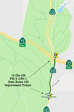 In October 2015, the CTC approved the following SHOPP funding: 12-Ora-133 3.1/3.6 Route 133 In
Laguna Beach, from 1700 feet south to 1300 feet north of El Toro Road.
Extend lanes in both directions. PAED: 02/01/17 R/W: 04/30/18 RTL:
05/31/18 CCA: 09/01/20 Costs: $1,230K (R/W); $3,870K (C). Completion
FY17/18. Support costs: PA & ED $1,215K; PS & E $1,820K; RW Sup
$550K; Con Sup $1,306K; Total $4,891K.
In October 2015, the CTC approved the following SHOPP funding: 12-Ora-133 3.1/3.6 Route 133 In
Laguna Beach, from 1700 feet south to 1300 feet north of El Toro Road.
Extend lanes in both directions. PAED: 02/01/17 R/W: 04/30/18 RTL:
05/31/18 CCA: 09/01/20 Costs: $1,230K (R/W); $3,870K (C). Completion
FY17/18. Support costs: PA & ED $1,215K; PS & E $1,820K; RW Sup
$550K; Con Sup $1,306K; Total $4,891K.
In October 2017, the CTC approved for future
consideration of funding a project, located in Orange County (12-Ora-133,
PM 3.1/3.6), that proposes to extend the north and southbound acceleration
lanes on Route 133 and re-align the El Toro Road westbound turn lane in
the city of Laguna Beach. The project is fully funded and programmed in
the 2016 SHOPP for $9,991,000. The project is estimated to begin
construction in Fiscal Year 202-21. The scope, as described for the
preferred alternative, is consistent with the project scope programmed by
the Commission in the 2016 SHOPP.
(Source: CTC October 2017 Agenda Item 2.2c.(1))
The following project was included in the final adopted 2018 SHOPP in March 2018: PPNO 12-Orange-133 3.1/3.6. On Route 133, In Laguna Beach, from 1,700 feet south to 1,300 feet north of El Toro Road. Extend lanes in both directions. Begin Con: 2/5/2021. Total Project Cost: $12,956K.
In December 2018, the CTC approved for future
consideration of funding a project located on Route 133 in Laguna Beach in
Orange County. The project proposes to improve safety at the Route 133/El
Toro intersection and improve drainage flow at the intersection. The
project proposes to widen existing shoulders and provide bike lanes. The
proposed project is estimated to cost approximately $41.1 million. This
project is funded through the State Highway Operations and Protection
Program (SHOPP) and the County of Orange and is currently programmed in
the 2018 SHOPP for approximately $21.4 million. Construction is estimated
to begin in 2021. The scope, as described for the preferred alternative,
is consistent with the project scope programmed by the Commission in the
2018 SHOPP.
(Source: December 2018 CTC Minutes, Agenda Item
2.2c(1))
In May 2019, the CTC approved the following SHOPP
Amendment 12-Ora-133 3.1/3.6 PPNO 4793 ProjID 1213000097. On Route 133 In
Laguna Beach, from 1,700 feet south to 1,300 feet north of El Toro Road.
Extend lanes in both directions. Increase R/W to $2,064; total to
$13,790K. Note: Due to refinements made during the design process, R/W
capital is increasing because of additional acquisition costs and permit
fees.
(Source: May 2019 Agenda Item 2.1c.(1) Amend Item
79)
In October 2020, the CTC approved the following SHOPP
Construction Phase allocation: $7,521,000 for Orange 12-Ora-133 PM
3.2/3.6. PPNO 12-4793 ProjID 1213000097 EA 0N060. Route 133 in Laguna
Beach, from 0.2 mile south to 0.2 mile north of El Toro Road. Outcome/Output:
Improve safety by extending the merge lanes in the northbound and
southbound directions. This project will reduce the number and
severity of collisions. Con Eng $2,109,000; Const $6,032,000. (CEQA - MND,
10/1/2018; Re-validation 6/5/2020) (NEPA - CE, 10/1/2018; Re-validation
6/5/2020) (Future consideration of funding approved under Resolution
E-17-66; October 2017.)
(Source: October 2020 CTC Agenda, Agenda Item
2.5b.(1) #27)
In February 2013, it was reported that during a highway-widening project
in California’s Laguna Canyon, scientists identified several new
species of early toothed baleen whales. Paleontologist Meredith Rivin of
the John D. Cooper Archaeological and Paleontological Center in Fullerton,
California, presented the finds at the 2013 annual meeting of AAAS. The
Laguna Canyon outcrop, excavated between 2000 and 2005, turned out to be a
treasure trove containing hundreds of marine mammals that lived 17 million
to 19 million years ago. It included 30 cetacean skulls as well as an
abundance of other ocean dwellers such as sharks. Among those finds were
four newly identified species of toothed baleen whale—a type of
whale that scientists thought had gone extinct 5 million years earlier.
(Source: ScienceNow, 2/17/13)
In January 2011, the CTC relinquished right of way in the city of Irvine along Route 133 at Laguna Canyon Road, consisting of collateral facilities.
In June 2001, the CTC considered a proposal to adopt a routing for Route 133 from ORA 4.1 at Route 73 to ORA 8.1 0.3mi S of I-405. This was part of an eventual project to widen the 2-lane highway to 4-lanes. As part of this project, Route 133 was rerouted in July/August 2004. Caltrans launched the project in January 2003, focusing on a four-mile section between the San Joaquin Hills Toll Road (Route 73) and the San Diego Freeway (I-405). The road, built in the early 1900s, carries 29,000 cars a day. When construction was completed in 2006, the roadway was less curvy, have a new drainage system and have two lanes in each direction. The lanes opened fully in October 2006. The $32 million project on the northern half of the road involved rerouted around two lakes, which will eliminate flooding during the rainy season. It also has wider shoulders and a center median. Crews built four trail and wildlife crossings that will promote wildlife access between open-space areas east and west of the road. Utility lines are now underground, and there is a new bike lane. There are 29,000 cars that use the road each day in 2006; in 2020, that number will swell to 32,000 to 56,000 cars a day. The road was originally a stagecoach route.
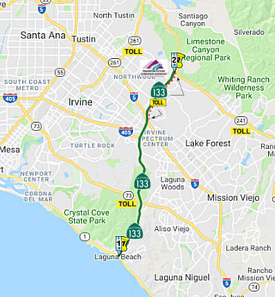
405-to-5 Auxillary Lane (12-Orange-133 PM 8.3/M9.3)
The following project was included in the final adopted 2018 SHOPP in March 2018: PPNO 4846. 12-Orange-133 8.5/M9.3. Route 133 In Irvine, from southbound I-5/SB Route 133 Connector to southbound Route 133/NB I-405 Connector. Construct a new auxiliary lane to improve traffic flow. Begin Con: 3/1/2022. Total Project Cost: $25,102K.
The 2020 SHOPP, approved in May 2020, included the
following Mobility item of interest (carried over from the 2018 SHOPP):
12-Orange-133 PM 8.5/M9.3 PPNO 4846 Proj ID 1214000130 EA 0N890. Route 133
in Irvine, from SB I-5/SB Route 133 Connector to southbound Route 133/NB
I-405 Connector. Construct a new auxiliary lane to improve traffic flow.
Programmed in FY21-22, with construction scheduled to start at the end of
March 2022. Total project cost is $26,808K, with $16,885K being capital
(const and right of way) and $9,923K being support (engineering,
environmental, etc.).
(Source: 2020 Approved SHOPP a/o May 2020)
In May 2020, the CTC approved for future consideration
of funding for the Route 133 Operation Improvements Project
(12-Ora-133, PM 8.3/9.3), which will construct a new auxiliary lane on
southbound Route 133 in Orange County. (PPNO 4846). The project is located
in the City of Irvine in Orange County and proposes to construct a new
auxiliary lane on Route 133 from the North Bound (NB) I-405 connector to
the South Bound (SB) I-5 connector. This new auxiliary lane will become
the second lane on the NB Interstate 405 connector. This project is
currently programmed in the SHOPP for $25,102,000, which includes
Construction (capital and support) and Right of Way (capital and support).
The total estimated project cost is $182,298,000. Construction is
estimated to begin 2021-2022. The scope, as described for the preferred
alternative, is consistent with the project scope programmed by the
Commission in the 2018 SHOPP.
(Source: May 2020 CTC Agenda, Agenda Item 2.2c.(1))
In May 2020, the CTC approved the following allocation:
12-Ora-133 8.5/M9.3. PPNO 4846 ProjID 1214000130 EA 0N890. Route 133
In Irvine, from southbound I-5/SB Route 133 Connector to southbound Route 133/NB I-405 Connector. Construct a new auxiliary lane to improve traffic
flow. Allocation: PS&E $3,224,000; R/W Support $652,000.
(Source: May 2020 CTC Agenda, Agenda Item 2.5b.(2)
#32)
In June 2021, the CTC approved the following SHOPP
amendment: 12-Ora-133 8.5/M9.3 8.3/M9.3 PPNO 4846
ProjID 1214000130 EA 12-0N890. Route 133 In Irvine, from 0.1 mile
south of Route 405 to Route 5 southbound I-5/SB Route 133
Connector to southbound Route 133/NB I-405 Connector. Construct a
new auxiliary lane to improve traffic flow. Note: Increase project limits
to accommodate temporary construction signs. Increase construction
capital because longitudinal cracking in lane three means that the
pavement will need to be rehabilitated. Adjust performance precision
from previously rounded amount. Revised numbers: Const Cap $16,632K
⇒ $18,232K; Total $26,808K ⇒ $28,408K.
(Source: June 2021 CTC Agenda, Agenda Item
2.1a.(2d) #56)
In June 2023, the CTC approved a request for
$30,385,000 for the SHOPP project on Route 133, in Orange County, in order
to advertise the project. This project (12-Ora-133 8.3/M9.3, PPNO 12-4846;
ProjID 1214000130; EA 0N890) is located on Route 133 in the City of
Irvine, from south of I-405 to I-5, in Orange County. The project
will construct an auxiliary lane in the southbound direction and
rehabilitate the pavement in lane three. In March 2018, this project was
programmed in the SHOPP for $14,926,000 in Construction Capital and
$4,544,000 in Construction Support for allocation in Fiscal Year
2021-22. In May 2020, the project was amended to modify the scope to
address scour under the bridge and convert an open channel to a box
culvert, which increased Construction Capital to $16,632,000. In June
2021, the project was further amended to modify the scope to rehabilitate
the pavement in lane three, which increased Construction Capital to
$18,232,000. In June 2022, the projects received an 18-month allocation
time extension for the Construction phase. In May 2023, the projects
received a 12-month expenditure time extension for the Plans,
Specifications, and Estimate phase. In April 2023, the Engineer’s
Estimate reflected the need of $24,977,000 in Construction Capital (37.0
percent over the programmed amount) and $5,408,000 in Construction Support
(19.0 percent over the programmed amount). The Department plans to
advertise the project in July 2023 and begin construction in January
2024. Construction is planned for four construction seasons with a
duration of 600 working days. The Construction Capital and Support
estimates are greater than the programmed amount due to current inflated
market prices for pavement and roadway excavation items in combination
with adjustments in construction due to the addition of a temporary sewer
bypass, California Department of Fish and Wildlife (CDFW) permit
requirements to install a streambed modification, and additional working
days for the project. The increase in support costs is primarily due to
CDFW requirements that the construction of the streambed modification be
inspected by a hydraulic engineer and increasing levels of environmental
monitoring that is required for both the functioning of the streambed
modification and construction in an environmentally sensitive area.
The project originally had 500 working days to facilitate the construction
of the original scope. With the addition of the streambed
modification work, an additional 100 working days will be required,
bringing the total to 600 working days. Allocation (Programmed / Allocated):
CON ENG $4,544,000 / $5,408,000; CONST $18,232,000 / $24,977,000.
(Source: June 2023 CTC Agenda, Agenda Item 2.5d.(5))
The 2020 Capital Improvement Plan for the TCA includes a study for the
potential for a new interchange on the Route 133 Toll Road at Great Park
Boulevard (Trabuco Road) (~ ORA 10.869). The intent of this new access is
to alleviate traffc demand at the nearby Sand Canyon Avenue/I-5
interchange. Preparation of a PSR-PDS document is underway by Five Points
Communities. F/ETCA, as a stakeholder, is coordinating with Five Points
Communities and the City of Irvine as the project development process
continues. A traffc and revenue study is being conducted by F/ETCA to
understand the traffic associated with the proposed interchange and any
changes in traffc volumes on The Toll Roads.
(Source: 2020 Fiscal Capital Improvement Plan, 6/13/2019)
 Exit Information
 Other WWW Links
 Naming
 The toll-free portions of this route (i.e., from Route 5 to Laguna Beach) is named the "Laguna
Freeway". It was named by the State Highway Commission in 1958,
extending from Irvine south to the outskirts of Laguna Beach. The first
segment of the Laguna Freeway opened in 1970.
The toll-free portions of this route (i.e., from Route 5 to Laguna Beach) is named the "Laguna
Freeway". It was named by the State Highway Commission in 1958,
extending from Irvine south to the outskirts of Laguna Beach. The first
segment of the Laguna Freeway opened in 1970.
(Image source: Mar/Apr 1958 California Highways and
Public Works, via Gribblenation Blog "California State Route 133")
 The toll portion of this route is called the East Leg of the Eastern Transportation Corridor.
(Image source: ACEC of California)
 The Laguna Canyon Road portion has been renamed the Veterans Memorial Highway. When this
was done is unknown, but there is at least one sign to this effect. It was
dedicated to the military veterans of Orange County, who numbered 252,000
at the time of the dedication in 1998.
The Laguna Canyon Road portion has been renamed the Veterans Memorial Highway. When this
was done is unknown, but there is at least one sign to this effect. It was
dedicated to the military veterans of Orange County, who numbered 252,000
at the time of the dedication in 1998.
(Image source: AARoads)
 Freeway
[SHC 253.1] From Route 73 to Route 241. Originally, the entire route was to be freeway (Route 1 to Route 5) was to be freeway (added to the Freeway and Expressway system in 1933); this was corrected by Assembly Bill 1650, Chapter 724, on 10/10/1999.
 Statistics
Overall statistics for Route 133 (as of 1995, before the tollway was constructed or defined for the route):
 Pre-1964 Legislative Route
In 1933, Chapter 767 defined the route from "Visalia to Woodlake" as a state route; in 1935, it was added to the code as LRN 133 with this definition. This is present-day Route 216, and runs between Route 63 and Route 245 (former Route 65).
© 1996-2020 Daniel P. Faigin.
Maintained by: Daniel P. Faigin
<webmaster@cahighways.org>.
 From Route
  Route 132
 Route 134