
 California Highways:
Click here for a key to the symbols used. An explanation of acronyms may be found at the bottom of the page.
 Routing
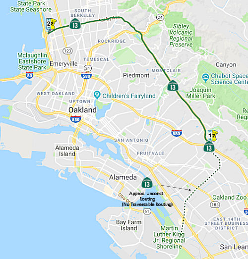 From Route 61 near the Oakland International Airport to
Route 61 near Emeryville via the vicinity of Lake Temescal.
From Route 61 near the Oakland International Airport to
Route 61 near Emeryville via the vicinity of Lake Temescal.
 Post 1964 Signage History
This route is as defined in 1963.
 Pre 1964 Signage History
 In 1934, Route 13 was signed along the route from Santa Cruz to
Jct. US 101 at San Rafael, via San Jose, Mt. Eden, and Oakland. Multiple
1935 maps, however, show the route as Route 17, so the renumbering
happened quickly after the original designation in 1934. This appears to
be the route of present-day Route 17 and I-880. Given the dates of
the segments below, it is likely the Route 13 number was not reused until
at least 1947, which was when LRN 227 was defined (the segment between
Route 24 and former US 40, defined in 1935, was signed as Route 24).
In 1934, Route 13 was signed along the route from Santa Cruz to
Jct. US 101 at San Rafael, via San Jose, Mt. Eden, and Oakland. Multiple
1935 maps, however, show the route as Route 17, so the renumbering
happened quickly after the original designation in 1934. This appears to
be the route of present-day Route 17 and I-880. Given the dates of
the segments below, it is likely the Route 13 number was not reused until
at least 1947, which was when LRN 227 was defined (the segment between
Route 24 and former US 40, defined in 1935, was signed as Route 24).
Between I-580 and the current Route 61 routing (Doolittle Dr., LRN 226 and LRN 258), present-day Route 13 was unsigned prior to 1964, but was LRN 258 (added to the state highway system in 1959).
Between Warren Blvd and US 50 (now I-580) and Ashby Ave (Route 24, LRN 206), Broadway (unsigned, LRN 75), Route 13 was partially constructed as of 1963 (it was only constructed between Route 24 and Joaquin Miller Road). The routing of present Route 13 (then unsigned) was along Warren Blvd and then an upspecified routing (perhaps Mountain Blvd) to US 50 (LRN 5). This was LRN 227, added to the state highway system in 1947.
Construction for this freeway occurred mostly in the late 1950s. By 1953,
the first segment of LRN 227 was shown on state highway maps as completed
south of Route 24 to Moraga Avenue, following Longvale Road and Mountain
Boulevard. By 1955, LRN 227 was constructed for 1.3 miles between
Thornhill Drive and Ascot Drive as a divided four lane highway. Also, in
1955, $300,000 dollars budgeted by the State for the 1956-57 fiscal year
towards the construction of LRN 227 between Route 24 and US 50 (future
I-580). By 1958, state highway maps were showing LRN 227 as
completed just south of Joaquin Miller Road. The segment of the Warren
Boulevard Freeway from Broadway Terrace to Lincoln Avenue opened in August
1958. By early 1960, LRN 227/Warren Boulevard Freeway was completed
from Broadway Terrace south to Redwood Road. The Route 13/Warren Boulevard
interchange at Moraga Avenue was compleed on April 15th, 1964. The Warren
Freeway was completed through Oakland in 1966, and completed to I-580
(former US 50) by 1967.
(Source: Gribblenation Blog (Tom Fearer), “California State Route 13 and the Warren Freeway”)
The Park Boulevard interchange was designed and designated as a future connection to the Shephard Canyon Freeway (then LRN 235, present-day unconstructed Route 77) through the Oakland Hills toward Moraga.
Between Route 24 and I-80 (former US 40), present-day Route 13 was LRN 206, but was signed as Route 24, until the Route 24 freeway alignment was completed in 1970. This segment was added to the state highway system in 1935.
Between I-80 (former US 40) and present-day Route 61, the routing (unconstructed) was also LRN 206. This portion of LRN 206 was added to the state highway system in 1959.
Constructed as freeway from I-580 to Route 24. Route 61 was a planned freeway that paralleled I-80 near Berkeley.
 Status
Oakland Separation Barrier (04-ALA-13 PM 6.7/7.2)
 The 2020 SHOPP, approved in May 2020, included the following Collision Reduction item of
interest (carried over from the 2018 SHOPP): 04-ALA-13 PM 6.7/7.2 PPNO
1490P Proj ID 0415000356 EA 4J490. Route 13 in Oakland, from 0.2 mile
north of Lincoln Avenue to 0.2 mile south of Park Boulevard. Install outer
separation barrier and construct rumble strips. Programmed in FY21-22,
with construction starting 2/1/2023. Total project cost is $5,190K, with
$3,092K being capital (const and right of way) and $2,098K being support
(engineering, environmental, etc.),
The 2020 SHOPP, approved in May 2020, included the following Collision Reduction item of
interest (carried over from the 2018 SHOPP): 04-ALA-13 PM 6.7/7.2 PPNO
1490P Proj ID 0415000356 EA 4J490. Route 13 in Oakland, from 0.2 mile
north of Lincoln Avenue to 0.2 mile south of Park Boulevard. Install outer
separation barrier and construct rumble strips. Programmed in FY21-22,
with construction starting 2/1/2023. Total project cost is $5,190K, with
$3,092K being capital (const and right of way) and $2,098K being support
(engineering, environmental, etc.),
(Source: 2020 Approved SHOPP a/o May 2020)
In March 2021, the CTC approved the following
pre-construction support phase allocation(s): (2a) #7. $800,000 (PS&E,
$667,000 programmed); $42,000 (R/W Sup). 04-Ala-13 6.7/7.2. PPNO 04-1490P;
ProjID 0415000356; EA 4J490. Route 13 In Oakland, from 0.2 mile north of
Lincoln Avenue to 0.2 mile south of Park Boulevard. Install outer
separation barrier and construct rumble strips. Prog. year 20-21.
(Source: March 2021 CTC Agenda, Agenda Item
2.5b.(2a) #7)
In May 2021, the CTC amended this project in the
SHOPP: (1d) #9. 04-Ala-13 6.7/7.2 PPNO 1490P ProjID 0415000356 EA
4J490. Route 13 In Oakland, from 0.2 mile north of Lincoln Avenue to 0.2
mile south of Park Boulevard. Install outer separation barrier, and
construct rumble strips. This was amended to adjust costs. During
PA&ED, additional tree removal, moment slab barrier, pavement and
excavation work were identified resulting in increased construction
support ($565K → $1,062K) and capital costs ($2,895K →
$5,344K). Revised total: $8,046K.
(Source: May 2021 CTC Agenda, Agenda Item 2.1a.(1d)
#9)
In January 2024, Caltrans released the draft 2024 SHOPP, which contained
the following project: 04-Alameda-13 7.4 /9.07. PPNO 04-2910E; ProjID
0421000328; EA 3W230. Route 13 In Oakland, at Park Boulevard Overcrossing
Bridge № 33-0159 (Poor); also at Broadway Terrace Undercrossing
Bridge № 33-0162 (Fair). Seismic retrofit one bridge and replace one
bridge. Proposed ($ × 1000): PA&ED: $1,620; PS&E: $3,610; R/W
$60; R/W Sup $240; Con $23,348; Con Sup: $6,130; Total: $35,008. Begin
Con: 4/3/2028.
(Source: 2024 Draft SHOPP v4.0, 1/31/2024)
Bruns Court Pedestrian Overcrossing (~ ALA 7.859)
In September 2023, it was reported that the Bruns Court
Pedestrian Overcrossing (~ ALA 7.859), which allows people to walk over
Route 13 and Moraga Avenue from Bruns Court to Montclair Park, must be
replaced because it is seismically unsafe. The structure is especially
vulnerable to collapse because it lies about 200 feet from the Hayward
Fault. Locals use the bridge to get to the park to play baseball and
pickleball, or to walk their kids to Montclair Elementary School without
crossing Moraga Avenue, which has two driving lanes each way and features
many speeding cars. According to Caltrans records, the overcrossing is
also non-compliant with the Americans with Disabilities Act and has
inadequate vertical clearance on the freeway and residential roads under
it. The bridge has been in use since 1956. Caltrans says it plans to
build a replacement which will be completed by 2026. The state is
partnering with Oakland’s Department of Transportation to develop
the new bridge, as its elements may force the city to take on more
financial and right-of-way responsibilities. There are four options under
consideration to replace the overcrossing:
(Source: Oaklandside, 9/27/2023)
In January 2024, the following pre-construction-phase
SHOPP SB1 Project allocation was on the agenda, but was withdrawn:
$3,160,000. 04-Ala-13 7.9. PPNO 04-2020L; ProjID 0418000023; EA 0P890.
Route 13 In Oakland, at Bruns Drive Pedestrian Overcrossing №
33-0244 (PM 7.91). Replace pedestrian overcrossing and upgrade
seismic safety. Concurrent consideration of funding under Resolution
E-24-02; January 2024. Twenty month allocation time extension for
PS&E and R/W Sup approved under Waiver 22-73; June 2022. Programmed
(Allocation, if different): PS&E $2,584,000 ($3,050,000);
R/W Sup $93,000 ($110,000). Withdrawn
Prior to Meeting.
(Source: January 2024 CTC Agenda, Agenda Item 2.5b.(2b) #6)
Berkeley ADA Ramps
In May 2019, the CTC approved the following SHOPP
allocation: $4,373,000 (Const, Const Engr). Alameda 04-Ala-13 12.1/13.4.
Route 13 In Berkeley, from Shattuck Avenue to 7th Street. Outcome/Output:
Upgrade curb ramps and sidewalks to meet the Americans with Disabilities
Act (ADA) standards, install detectable warning surface, and restripe
crosswalks.
(Source: May 2019 CTC Minutes, Agenda Item 2.5b.(1)
Item 7)
In June 2019, the CTC approved the following SHOPP
scope amendments:
(Source: June 2019 CTC Minutes, Agenda Item
2.1a.(1) Scope Items 40, 41)
The 2020 SHOPP, approved in May 2020, included the ADA
Ramp Project (carried over from the 2018 SHOPP): 04-ALA-13 PM 10.7/13.0
PPNO 1490P Proj ID 0419000091 EA 2G461. Route 13 in Berkeley, from Domingo
Avenue to Mabel Street. Upgrade curb ramps and repair sidewalks to meet
Americans with Disabilities Act (ADA) standards. Programmed in
FY21-22, with construction starting 1/12/2023. Total project cost is
$6,095K, with $5,110K being capital (const and right of way) and $985K
being support (engineering, environmental, etc.),
(Source: 2020 Approved SHOPP a/o May 2020)
Unconstructed Portion
 Unconstructed for 4 miles from Route 61 to Route 580. This section would have paralelled
Hegenberger Road and 73rd Avenue. However, no local roads adequately fit
the definition of a traversable highway. The 4.3 miles that were in the
freeway and expressway system were deleted effective 1/1/1982.
Unconstructed for 4 miles from Route 61 to Route 580. This section would have paralelled
Hegenberger Road and 73rd Avenue. However, no local roads adequately fit
the definition of a traversable highway. The 4.3 miles that were in the
freeway and expressway system were deleted effective 1/1/1982.
The 2013 Traversable Highways report notes, for the two segments from
Route 61 to Route 580, and from Route 80 to Route 61: No local roads
adequately fit the description of a traversable highway. 4.3 miles were
deleted from the F&E System effective 1/1/82. No
recommendation.
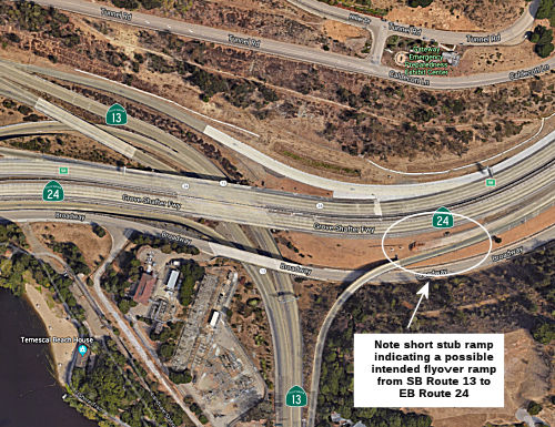
Sean Tongson notes that a short stub of concrete at the on-ramp from northbound Route 13 to eastbound Route 24 seems to suggest a possible flyover/under ramp may have been planned from southbound Route 13 to eastbound Route 24.
 Naming
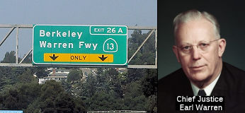 Route 13 from I-580 to Route 24 in Oakland (~ ALA 4.262 to ALA
R9.421) is named the "Warren Freeway". Earl Warren (March 19, 1891
– July 9, 1974) was an American politician and jurist who served as
the Governor of California from 1943 to 1953 and Chief Justice of the
United States from 1953 to 1969. The "Warren Court" presided over a major
shift in American constitutional jurisprudence, which has been recognized
by many as a "Constitutional Revolution" of the liberal, with Warren
writing the majority opinions in landmark cases such as Brown v. Board of
Education (1954), Reynolds v. Sims (1964), Miranda v. Arizona (1966) and
Loving v. Virginia (1967). Warren also led the Warren Commission, a
presidential commission that investigated the 1963 assassination of
President John F. Kennedy. He is the last Chief Justice to have served in
an elected office before entering the Supreme Court, and is generally
considered to be one of the most influential Supreme Court justices and
political leaders in the history of the United States. Warren was born in
1891 in Los Angeles and was raised in Bakersfield, California. After
graduating from the law program at the University of California, Berkeley,
he began a legal career in Oakland. He was hired as a deputy district
attorney for Alameda County in 1920 and was appointed district attorney in
1925. He emerged as a leader of the state Republican Party and won
election as the Attorney General of California in 1938. In that position,
he played a role in the forced removal and internment of over 100,000
Japanese Americans during World War II. In the 1942 California
gubernatorial election, Warren defeated incumbent Democratic governor
Culbert Olson. He would serve as Governor of California until 1953,
presiding over a period of major growth for the state. Named by Assembly
Concurrent Resolution 96, Chap. 166 in 1957.
Route 13 from I-580 to Route 24 in Oakland (~ ALA 4.262 to ALA
R9.421) is named the "Warren Freeway". Earl Warren (March 19, 1891
– July 9, 1974) was an American politician and jurist who served as
the Governor of California from 1943 to 1953 and Chief Justice of the
United States from 1953 to 1969. The "Warren Court" presided over a major
shift in American constitutional jurisprudence, which has been recognized
by many as a "Constitutional Revolution" of the liberal, with Warren
writing the majority opinions in landmark cases such as Brown v. Board of
Education (1954), Reynolds v. Sims (1964), Miranda v. Arizona (1966) and
Loving v. Virginia (1967). Warren also led the Warren Commission, a
presidential commission that investigated the 1963 assassination of
President John F. Kennedy. He is the last Chief Justice to have served in
an elected office before entering the Supreme Court, and is generally
considered to be one of the most influential Supreme Court justices and
political leaders in the history of the United States. Warren was born in
1891 in Los Angeles and was raised in Bakersfield, California. After
graduating from the law program at the University of California, Berkeley,
he began a legal career in Oakland. He was hired as a deputy district
attorney for Alameda County in 1920 and was appointed district attorney in
1925. He emerged as a leader of the state Republican Party and won
election as the Attorney General of California in 1938. In that position,
he played a role in the forced removal and internment of over 100,000
Japanese Americans during World War II. In the 1942 California
gubernatorial election, Warren defeated incumbent Democratic governor
Culbert Olson. He would serve as Governor of California until 1953,
presiding over a period of major growth for the state. Named by Assembly
Concurrent Resolution 96, Chap. 166 in 1957.
(Biographical information source: Wikipedia; Image sources: History.Com; Corco Highways)
This is also "Tunnel" Road and "Ashby" Avenue.
 Interstate Submissions
The portion from Route 580 to Route 24 was submitted for inclusion in the interstate system in 1945; it was not accepted.
The designation I-13 was proposed in November 1957 for what is now I-605. This was rejected by AASHTO. The I-605 routing was later proposed as I-105, before the number I-605 was chosen.
 Freeway
[SHC 253.2] From Route 61 near the Oakland International Airport to Route 24; from Route 80 to Route 61 near Emeryville. Constructed to freeway standards from Route 580 to Route 24. The entire route was added to the Freeway and Expressway system in 1959; the portion from Route 24 to Route 80 was deleted in 1981 by Chapter 292.
 Scenic Route
[SHC 263.3] From Route 24 to Route 580. Designated by Senate Bill 1036, Chaptered 7/21/2005, Chapter 101.
 Classified Landcaped Freeway
The following segments are designated as Classified Landscaped Freeway:
| County | Route | Starting PM | Ending PM |
| Alameda | 13 | 5.29 | 5.57 |
| Alameda | 13 | 8.09 | 8.49 |
| Alameda | 13 | 9.05 | 9.50 |
 Exit Information
 Other WWW Links
 Statistics
Overall statistics for Route 13:
 Pre-1964 Legislative Route
The route that would become LRN 13 was first defined in Chapter 111 of the 1901 statutes: "That portion of the Sonora and Mono wagon road, commencing E of Sonora and at a point commonly known as Long Barn in Tuolumne Cty and running thence across the summit of the Sierra Nevada mountains to Bridgeport in Mono County is hereby declared a state highway." This route was also referenced by Chapter 150 in the 1905 statutes. It was first funded in the 1909 First Bond Act as a route "From Salida to Sonora". In May 1919, Chapter 510 re-declared this routing to be a state highway, "All that portion of the public highway commencing at the end of the Sonora and Mono state highway at Long Barn in Tuolumne county and leading therefrom to the eastern boundary of the city of Sonora and known as the Sonora and Mono Road is hereby declared to be a state highway...". Thus, in 1935, the routing was codified into the highway code as:
The portion from Salida to Sonora was considered a primary highway.
This route had the following pieces:
© 1996-2020 Daniel P. Faigin.
Maintained by: Daniel P. Faigin
<webmaster@cahighways.org>.
 Route 12
 Route 14