
 California Highways:
Click here for a key to the symbols used. An explanation of acronyms may be found at the bottom of the page.
 Routing
 Post 1964 Signage History
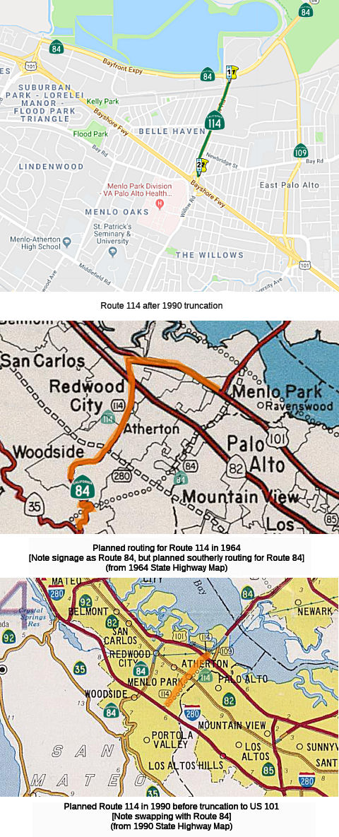
As defined in 1963, this route ran from “Route 280 near Woodside to Route 101 at the Harbor Boulevard Interchange in Redwood City.”
In 1984, Chapter 409 swapped a portion of Route 114 and Route 84, moving Route 84 to the northern (LRN 214) alignment, and giving Route 114 the old Route 84 alignment. This made the definition of Route 114 "Route 280 in Menlo Park to Route 84." The current routing runs along Willow Road.
In 1990, Chapter 1187 truncated the route, changing the origin to Route 101 in East Palo Alto"
Over on AAroads, Sparker had some interesting observations on the routing shift (edited slightly):
Sometime in the mid-'70's, the definition of Route 84 and Route 114 "swapped" alignments; originally Route 114 was supposed to be Woodside Road from US 101 west to I-280, while Route 84 went west through Menlo Park and Stanford to I-280; the intent was to jog north on I-280 to the current Route 84 alignment, while Route 114 would head east and Route 84 west. Obviously D4 planners had likely never met or conversed with residents in Menlo Park, Palo Alto, as well as Stanford student activists; the plan to put an expressway or freeway largely down San Francisquito Creek (the dividing line between Santa Clara and San Mateo counties) would have been summarily abandoned if the residents could and would be heard. But it took about a dozen years after the Route 84 line on the map was drawn until the concept was effectively dead (money talks very loudly in that area!), and Route 84 was moved up to Redwood City. Route 114 took over the Menlo Park alignment, but a formal route adoption never took place. The only consistent backers of the plan were the owners of the Stanford Shopping Center; the route would have passed along the north end of their parking lot! But once Stanford announced that they would never sign street-closure agreements for the route if it came to pass, the plans were cut back -- first to Route 82, and then all the way to US 101. Route 114 never stood a chance in this area -- and Caltrans District 4, despite periodic (and possibly quixotic) attempts at trailblazer signage along US 101, has no plans to sign the short "stub" route.
(Source: Sparker on AARoads, 6/19/2018)
 Pre 1964 Signage History
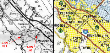 This is a proposed routing of LRN 107. The constructed routing of LRN 107 is to
the NW, and was surface Route 84. A new Route 84 was built in the early
1980s as part of the Dumbarton Bridge project, and the old portion was
resigned as Route 114. The unbuilt portion of Route 114 was at one time
designated as Route 84, and present-day Route 84 between US 101 and I-280
was Route 114. The current Route 84 portions were defined in 1959.
This is a proposed routing of LRN 107. The constructed routing of LRN 107 is to
the NW, and was surface Route 84. A new Route 84 was built in the early
1980s as part of the Dumbarton Bridge project, and the old portion was
resigned as Route 114. The unbuilt portion of Route 114 was at one time
designated as Route 84, and present-day Route 84 between US 101 and I-280
was Route 114. The current Route 84 portions were defined in 1959.
 In July 1964, the Highway Commission adopted a 1.7 mi freeway location for Route 84 between
the adopted route for I-280 and Santa Cruz Avenue in Menlo Park, following
the general alignment of Sand Hill Road. The requirement was that this
freeway comply with the master plan for scenic highways. The alternative
considered was a routing along Alpine Road. San Mateo and Santa Clara
preferred the Sand Hill routing; Palo Alto favored Alpine Road. Stanford
opposed the Alpine Route. Note that this routing was later renumbered as
Route 114, and then the segment between I-280 and US 101 was deleted from
the Route 114 definition.
In July 1964, the Highway Commission adopted a 1.7 mi freeway location for Route 84 between
the adopted route for I-280 and Santa Cruz Avenue in Menlo Park, following
the general alignment of Sand Hill Road. The requirement was that this
freeway comply with the master plan for scenic highways. The alternative
considered was a routing along Alpine Road. San Mateo and Santa Clara
preferred the Sand Hill routing; Palo Alto favored Alpine Road. Stanford
opposed the Alpine Route. Note that this routing was later renumbered as
Route 114, and then the segment between I-280 and US 101 was deleted from
the Route 114 definition.
Pre 1964, Route 114 would've taken a different route between the Dumbarton Bridge and US 101 than it (as signed Route 84) does now: it would've cut between current Route 109 and current Route 114/signed Route 84, then continued west about a mile south of Willow Road, before subsuming Willow Road west of current Route 82, ending near current I-280.
Route 114 was not defined as part of the initial state signage of routes in 1934. It is unclear what (if any) route was signed as Route 114 between 1934 and 1964.
 Status
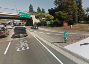 For the longest time, this route was not signed as Route 114. In August 2015, it was reported that Google Maps had actually
captured an image of the route being signed, at the offramp for Willow
Road east from US 101. However, it appears that with construction in the
area, this sign may be gone.
For the longest time, this route was not signed as Route 114. In August 2015, it was reported that Google Maps had actually
captured an image of the route being signed, at the offramp for Willow
Road east from US 101. However, it appears that with construction in the
area, this sign may be gone.
 Other WWW Links
 Statistics
Overall statistics for Route 114 (this reflects only the portion from US 101 to Route 84):
 Pre-1964 Legislative Route
In 1933, Chapter 767 defined the route from "[LRN 68] near Sunnyvale to Los Gatos-Saratoga Gap Road" as a state highway. In 1935, this was codified as LRN 114 with the following definition:
In 1959, Chapter 1841 changed the definition to originate at [LRN 5] (Route 17).
In 1961, Chapter 1146 changed the definition to begin as [LRN 2] (US 101) near Ford Road.
This route ran from US 101 near Ford Road to Bypass US 101 near Mountain View. This is present-day Route 85.
© 1996-2020 Daniel P. Faigin.
Maintained by: Daniel P. Faigin
<webmaster@cahighways.org>.
 From Route
  Route 113
 Route 115