
 California Highways:
Click here for a key to the symbols used. An explanation of acronyms may be found at the bottom of the page.
 Routing
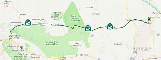 From Route 10 near Whitewater to the Arizona state line near
Earp via Morongo Valley, the vicinity of Yucca Valley, Twentynine Palms,
Rice, and Vidal Junction.
From Route 10 near Whitewater to the Arizona state line near
Earp via Morongo Valley, the vicinity of Yucca Valley, Twentynine Palms,
Rice, and Vidal Junction.
 Post 1964 Signage History
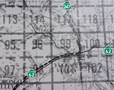 As defined in 1963, Route 62 was the route from
"Route 10 near White Water to Utah Trail Road in the town of Twentynine
Palms via Morongo Valley and the vicinity of Yucca Valley."
As defined in 1963, Route 62 was the route from
"Route 10 near White Water to Utah Trail Road in the town of Twentynine
Palms via Morongo Valley and the vicinity of Yucca Valley."
In 1970, Chapter 1473 extended the route to the Arizona state line near Earp via Morongo Valley, the vicinity of Yucca Valley, Twentynine Palms, Rice, and Vidal Junction.
In 1981, Chapter 292 fixed a typographical error, changing "White Water" to "Whitewater"
This route was originally planned as freeway from Route 10 to Route 247, where it would have connected to the Old Woman Springs Freeway and continued to Route 18.
Much of what is now Route 62 east of Route 177 was built by the
Metropolitan Water District of Southern California as the Colorado River
Aqueduct Road. Construction of the Colorado River Aqueduct began
during January 1933 near Thousand Palms and was made functional on January
7, 1939. The Colorado River Aqueduct Road (Aqueduct Road) was
constructed from Parker Dam west towards modern day Route 62 in San
Gorgonio Pass. Modern Route 177 and Dillon Road are also segments of
road that was originally built as Aqueduct Road.
(Source: Gribblenation Blog (Tom Fearer), "California State Route 62", 5/23/2023)
In the Initial Study and Proposed MND for the Route 62 Safety
Improvements, Caltrans described the route as follows:
(Source: Route 62 Safety Improvments Initial Study and Proposed MND, April 2018)
Route 62 begins at I-10 near Whitewater and ends east of Earp at the Arizona state line. Generally, an east-west route, it parallels I-10 (I-10 is to the south). Near the state line, Route 62 joins with Arizona 95, a north-south route. Route 62 is a 4-lane divided expressway from the junction with I-10 to 0.8 mile east of the Riverside/ San Bernardino County line. From 0.8 mile east of the Riverside/San Bernardino County line to Sherwood Road immediately east of Yucca Valley, Route 62 is a four-lane divided conventional highway. From Sherwood Road to Adobe Road, in Twentynine Palms, Route 62 is a four-lane undivided conventional highway. From Adobe Road to the Arizona state line, Route 62 is a two-lane conventional highway. Route 62 traverses unincorporated portions of northern Riverside County and southern San Bernardino County. The route serves the unincorporated communities of Morongo Valley, Joshua Tree and Earp, the Town of Yucca Valley, the City of Twentynine Palms, and the United States Marine Corps Air/Ground Combat Training Center in Twentynine Palms. Route 62 is 151.9 miles in length and lies entirely within Caltrans District 8 jurisdiction.
 Pre 1964 Signage History
This routing was LRN 187 between US 60/US 70/US 99 (LRN 26) and Yucca Valley. This was defined in two portions: Route 10 to Morongo Valley in 1933; the remainder in 1959. It is unclear how this was signed.
The route was LRN 218 between Yucca Valley and Twentynine Palms. This was defined in 1961. The remainder of the route was defined in 1970.
Route 62 was not defined as part of the initial state signage of routes in 1934. It is unclear what (if any) route was signed as Route 62 between 1934 and 1964.
 Status
Pierson Boulevard Intersection Improvements (08-Riv-62 R3.0/R3.7)
In January 2024, the CTC amended the following project
into the 2022 SHOPP: 08-Riv-62 R3.0/R3.7. PPNO 08-3021M; ProjID
0823000063; EA 1N880. Route 62 In and Near Desert Hot Springs, at the
intersection with Pierson Boulevard. Install traffic signals.
Allocation ($ × $1000) PA&ED $1,287; PS&E $1,744; R/W Sup
$192; ⊘Con Sup $1,756 ; ⊘R/W Cap $268; ⊘Const
Cap $3,299; TOTAL $8,546. FY26-27. Concurrent COS allocation under
Resolution FP-23-65; January 2024. BC: 5/9/2027
(Source: January 2024 CTC Agenda, Agenda Item 2.1a #10)
In January 2024, the CTC approved the following
pre-construction-phase SHOPP allocation: $1,287,000. 08-Riv-62 R3.0/R3.7.
PPNO 08-3021M; ProjID 0823000063; EA 1N880. Route 62 In and Near Desert
Hot Springs, at the intersection with Pierson Boulevard. Install
traffic signals. Concurrent Amendment under SHOPP Amendment 22H-016;
January 2024. Programmed (Allocation, if different):
PA&ED: $$1,287,000.
(Source: January 2024 CTC Agenda, Agenda Item 2.5b.(2a) #16)
In May 2013, the CTC authorized $15,309,000 to overlay 25.6 lane miles of pavement, widen 12 lane miles of inside shoulder, overlay bridge decks with polyester concrete, reconstruct metal beam guardrail, and make drainage improvements near Desert Hot Springs, from Route 10 (~ RIV R0.0) to Indian Avenue (likely Indian Canyon Dr, which is RIV R6.451, and which accounts for 12 lane miles of inside shoulder). Project will improve safety and ride quality.
In April 2021, it was reported that a road construction project set for
more than 20 miles of Route 62 in Riverside and San Bernardino counties
was starting. The $48 million project will see a new layer of pavement
placed on two major segments of Highway 62. The first is from Indian
Canyon Drive near Desert Hot Springs (~ RIV R6.468) to roughly Yucca Mesa
Road in Yucca Valley (~ SBD 15.135). The work will pick up again in
Twentynine Palms, from Bermuda Avenue (~ SBD 28.809) to near Utah Trail (~
SBD 34.23). Work is set to wrap up in the summer of 2023. Emily Leinen of
Caltrans said the skipped section in Joshua Tree is expected to be part of
a future project, but did not elaborate. Along with new pavement, the
thoroughfare will be getting new raised curb medians, new stretches of
sidewalks and reconstructed curb ramps compliant with the Americans With
Disabilities Act. New road striping and signage are also in the plans.
Certain traffic signals will also be upgraded with new pedestrian-friendly
improvements.
(Source: Desert Sun, 4/2/2021)
TCRP Project #129 in Yucca Valley
![[062 Improvements]](maps/062-improvements.jpg) TCRP Project #129 will add traffic and pedestrian safety and utility
undergrounding projects in the Route 62 right of way. In April 2008, the
Town of Yucca Valley requested amending the project to redistribute
$600,000 in TCRP funds from Construction to Environmental (PA&ED) and
to update the project schedule and funding plan. By constructing safety
improvements and utility undergrounding, this project will reduce the
accident rate and provide safety improvements for pedestrians and
motorists along Route 62 between La Honda Way (~ SBD 9.627) and Dumosa
Avenue (~ SBD 12.19) in the town of Yucca Valley. Other project
improvements include sidewalk construction, associated drainage, and
raised medians to prevent unauthorized left turn movements. Eliminating
accidents and left turns will result in reduced traffic congestion on
Route 62. The Environmental (PA&ED) work began in May 2002. However,
work on the project was suspended due to uncertainties with the project
funding. When work resumed, it was determined that the previous traffic
studies and other analysis had become outdated and would need to be
updated. The project is now scheduled for construction in FY 2009/2010.
The PA&ED was completed in February 2009, with $298,000 in TCRP
savings. The Plans, Specification, and Estimates (PS&E) started in
November 2009. The project has been under development for many years.
Based upon a 2010 update to the project costs, the PS&E has increased
from $240,000 to $538,000. This shortfall was covered in September 2010 by
reprogramming $298,000 TCRP savings from PA&ED.
TCRP Project #129 will add traffic and pedestrian safety and utility
undergrounding projects in the Route 62 right of way. In April 2008, the
Town of Yucca Valley requested amending the project to redistribute
$600,000 in TCRP funds from Construction to Environmental (PA&ED) and
to update the project schedule and funding plan. By constructing safety
improvements and utility undergrounding, this project will reduce the
accident rate and provide safety improvements for pedestrians and
motorists along Route 62 between La Honda Way (~ SBD 9.627) and Dumosa
Avenue (~ SBD 12.19) in the town of Yucca Valley. Other project
improvements include sidewalk construction, associated drainage, and
raised medians to prevent unauthorized left turn movements. Eliminating
accidents and left turns will result in reduced traffic congestion on
Route 62. The Environmental (PA&ED) work began in May 2002. However,
work on the project was suspended due to uncertainties with the project
funding. When work resumed, it was determined that the previous traffic
studies and other analysis had become outdated and would need to be
updated. The project is now scheduled for construction in FY 2009/2010.
The PA&ED was completed in February 2009, with $298,000 in TCRP
savings. The Plans, Specification, and Estimates (PS&E) started in
November 2009. The project has been under development for many years.
Based upon a 2010 update to the project costs, the PS&E has increased
from $240,000 to $538,000. This shortfall was covered in September 2010 by
reprogramming $298,000 TCRP savings from PA&ED.
In January 2013, the CTC authorized $778,000 to the Town of Yucca Valley for Route 62 Median and Sidewalk Improvements. This project, in the town of Yucca Valley, on Route 62 from La Honda Way to Dumosa Avenue will provide sidewalks and install raised medians.
In March 2013, the CTC authorized $723,000 to the Town of Yucca Valley for Route 62 Improvements between Apache Trail (~SBD 10.823) & Palm Avenue (~ SBD 11.37). This project will construct traffic and pedestrian safety improvements.
Painted Median Islands: Yucca Valley and Twentynine Palms ( 08-SBd-62 15.3/28.9)
In June 2020, the CTC amended the following project
into the SHOPP: 08-SBd-62 15.3/28.9. PPNO 3016T. ProjID 0820000011. EA
1L290. On Route 62 in and near Yucca Valley and Twentynine Palms, from
east of Yucca Mesa Road/La Contenta Road to Alfalfa Avenue/Sherman Road.
Restripe existing two-way left-turn lanes to painted median islands and
install rumble strips. PA&ED $686K; PS&E $522K; R/W Sup $26K; Con
Sup $504K; R/W Cap $20K; Const Cap $1,226K; Total $2,984K. BC: 4/1/2022.
(Source: June 2020 CTC Agenda, Agenda Item
2.1a.(5a) #10)
In May 2021, the CTC amended this project in the
SHOPP: (1d) #48. 08-SBd-62 15.3/28.9 PPNO 3016T ProjID
0820000011 EA 1L290. Route 62 In and near Yucca Valley and
Twentynine Palms, from east of Yucca Mesa Road/La Contenta Road to
Alfalfa Avenue/Sherman Road. Restripe existing two-way left-turn
lanes to painted median islands and install rumble strips. Amended
to delete project. The scope of this project has been added to a
maintenance project EA 08-1L670 which overlaps the postmile limits and
construction schedule of this project.
(Source: May 2021 CTC Agenda, Agenda Item 2.1a.(1d)
#48)
In August 2017, it was reported that Caltrans announced the completion of
a project in Joshua Tree (~ SBD 18.305) that actively incorporates
complete streets concepts, designed to accommodate all users. The project
on Route 62 in Joshua Tree used funds from a current construction project
to restripe the downtown section of Joshua Tree with bike lanes and
diagonal parking in order to more safely move vehicles, pedestrians and
bicyclists through the downtown business district. The majority of Route 62 is a four-lane highway with two lanes in each direction with
approximately eight foot shoulders. The section of Route 62 through
downtown Joshua Tree has outside shoulders that extend over forty
feet—space now being used to stripe out areas to park, add bike
lanes and create more controlled lanes. The striping improvements will
make it easier and safer for vehicles to park, exit the highway and
prevent illegal passing. It will also provide better access for bicyclists
and enhance safety for all users of the downtown area.
(Source: Palm Desert Patch, 8/18/2017)
Route 62 Widen Shoulders and Install Rumble Strips Project | 08-SBD-62 (PM 41.0/41.5 AND 60.6/61.1), 08-RIV-62 (PM 81.6/82.2)
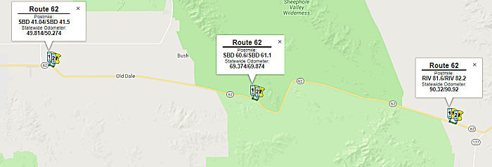 In April 2018, Caltrans posted a draft Initial Study and Proposed MND
regarding the Route 62 Widen Shoulders and Install Rumble Strips project.
This covers three distinct segments of Route 62: 08-SBD-62 (PM 41.0/41.5
AND 60.6/61.1), and DISTRICT 08-RIV-62 (PM 81.6/82.2) [Note: Route 62 has
two segments in RIV: 0.0-9.237 near Desert Hot Springs, and another
segment starting at ~ RIV 79.525 (continuing numbering from SBD) and going
to RIV 90.202 (and then continuing number back into SBD)]. The project
proposes to widen the outside shoulder of Route 62 to eight feet in both
directions and install ground-in rumble strips on the centerline and on
the outside shoulders. The proposed project is located in a rural setting
on Route 62 at post miles (PM) 41 to 41.5 (Segment 1) and PM 60.6 to 61.1
(Segment 2) within San Bernardino County, and from PM 81.6 to 82.2
(Segment 3) in Riverside County. The project is within the Cadiz Valley
Southeast, Valley Mountain, and Clarks Pass 7.5 minute U.S. Geological
Survey (USGS) topographic quadrangles. Within the project limits, Route 62
is a two-lane conventional highway that traverses unincorporated portion
of southern San Bernardino County and northern Riverside County. Existing
shoulder widths for the segment of the route within the project vicinities
vary from zero to four feet wide. The existing shoulder widths do not meet
current Caltrans Highway Design Manual Standards. The posted speed limit
along these segments of Route 62 is 50 to 55 miles per hour (mph). The
highway is on relatively flat terrain and is part of the Terminal Access
Route to the National Network for Surface Transportation Assistance Act
(STAA) trucks. The section of Route 62 experiences a higher than average
incidence of cross-centerline accidents.
In April 2018, Caltrans posted a draft Initial Study and Proposed MND
regarding the Route 62 Widen Shoulders and Install Rumble Strips project.
This covers three distinct segments of Route 62: 08-SBD-62 (PM 41.0/41.5
AND 60.6/61.1), and DISTRICT 08-RIV-62 (PM 81.6/82.2) [Note: Route 62 has
two segments in RIV: 0.0-9.237 near Desert Hot Springs, and another
segment starting at ~ RIV 79.525 (continuing numbering from SBD) and going
to RIV 90.202 (and then continuing number back into SBD)]. The project
proposes to widen the outside shoulder of Route 62 to eight feet in both
directions and install ground-in rumble strips on the centerline and on
the outside shoulders. The proposed project is located in a rural setting
on Route 62 at post miles (PM) 41 to 41.5 (Segment 1) and PM 60.6 to 61.1
(Segment 2) within San Bernardino County, and from PM 81.6 to 82.2
(Segment 3) in Riverside County. The project is within the Cadiz Valley
Southeast, Valley Mountain, and Clarks Pass 7.5 minute U.S. Geological
Survey (USGS) topographic quadrangles. Within the project limits, Route 62
is a two-lane conventional highway that traverses unincorporated portion
of southern San Bernardino County and northern Riverside County. Existing
shoulder widths for the segment of the route within the project vicinities
vary from zero to four feet wide. The existing shoulder widths do not meet
current Caltrans Highway Design Manual Standards. The posted speed limit
along these segments of Route 62 is 50 to 55 miles per hour (mph). The
highway is on relatively flat terrain and is part of the Terminal Access
Route to the National Network for Surface Transportation Assistance Act
(STAA) trucks. The section of Route 62 experiences a higher than average
incidence of cross-centerline accidents.
(Source: Route 62 Safety Improvments Initial Study and Proposed MND, April 2018)
In August 2018, the CTC approved $2,715,000 in SHOPP
funding for San Bernardino 08-SBd-62 41.0/41.5 Route 62 Near Twentynine
Palms, from 0.7 mile to 1.2 miles east of Godwin Road and from 5.6 miles
to 6.1 miles east of Ironage Road. Outcome/Output: Widen shoulders and
construct rumble strips. This project will increase safety and reduce the
number and severity of collisions.
(Source: August 2018 CTC Agenda Item 2.5f.(3) Item
11)
In August 2018, the CTC approved for future
consideration of funding the following project for which a Mitigated
Negative Declaration (MND) has been completed: Route 62 in San Bernardino
and Riverside Counties (08-SBd-62, PM 41.04/41.5 & 60.6/61.1,
08-Riv-62, PM 81.6/82.2). Construct roadway improvements on a portion of
Route 62 in San Bernardino and Riverside Counties. (PPNO 0225K) This
project is located on Route 62 in San Bernardino and Riverside Counties.
This project consists of three segments of project limits and proposes to
widen shoulders and install ground-in rumble strips on Route 62. The
purpose of the proposed project is to reduce the number and severity of
cross-centerline collisions on Route 62. The proposed project is estimated
to cost $5.03 million and is programmed in the 2016 SHOPP program for
approximately $6.2 million. Construction is estimated to begin in funding
Fiscal Year 2018-19. The scope, as described for the preferred
alternative, is consistent with the project scope programmed by the
Commission in the 2016 SHOPP.
(Source: August 2018 CTC Agenda Item 2.2c(1))
In December 2009, the CTC approved for future funding a project that will construct a non-capacity-increasing bridge to replace the existing Colorado River Bridge near the city of Earp (~ SBD 142.718) to correct scour deficiencies. The project is fully funded in the 2008 State Highway Operation and Protection Program. Total estimated cost is $29,627,000, capital and support. Construction is estimated to begin in Fiscal Year 2009-10.
 Naming
The portion of this route from I-10 to Route 177 (~ RIV 0.385 to RIV 84.608) is named the "Twenty-Nine Palms Highway". It was named by Assembly Concurrent Resolution 164, Chapter 121, in 1990.
 The portion of this route from 5.4 miles west to 4.6 miles east of the
intersection with Route 177 in Riverside County (~ RIV 79.208 to RIV
89.208) is named the "CHP Officer Daniel J.
Muehlhausen Memorial Highway". Named in honor of California Highway
Patrol Officer Daniel J. Muehlhausen, badge number 13933, who was killed
in the line of duty on June 1, 1997. Officer Muehlhausen was struck by an
errant driver while en route to assist a disabled motorist on eastbound
Route 62 east of Route 177, and succumbed to his injuries as a result of
the this collision. He was born on August 8, 1966, in Hemet, California.
He lived in Riverside, California where he attended and graduated from
Notre Dame High School. Prior to beginning his career with the California
Highway Patrol, Daniel J. Muehlhausen graduated from the University of
California, Riverside, with a degree in Philosophy. He joined the CHP on
October 17, 1994. After successfully completing his academy training on
April 20, 1995, he reported to the Indio area, where he made significant
contributions to traffic safety and to the motoring public while assigned
to the Indio office of the California Highway Patrol. He served two years
as a sworn peace officer for the California Highway Patrol and was known
by his fellow officers for his dedication to the department and to the
protection of the citizens of this state. Named by Assembly Concurrent
Resolution 29, Chaptered 7/8/2003, Chapter 90.
The portion of this route from 5.4 miles west to 4.6 miles east of the
intersection with Route 177 in Riverside County (~ RIV 79.208 to RIV
89.208) is named the "CHP Officer Daniel J.
Muehlhausen Memorial Highway". Named in honor of California Highway
Patrol Officer Daniel J. Muehlhausen, badge number 13933, who was killed
in the line of duty on June 1, 1997. Officer Muehlhausen was struck by an
errant driver while en route to assist a disabled motorist on eastbound
Route 62 east of Route 177, and succumbed to his injuries as a result of
the this collision. He was born on August 8, 1966, in Hemet, California.
He lived in Riverside, California where he attended and graduated from
Notre Dame High School. Prior to beginning his career with the California
Highway Patrol, Daniel J. Muehlhausen graduated from the University of
California, Riverside, with a degree in Philosophy. He joined the CHP on
October 17, 1994. After successfully completing his academy training on
April 20, 1995, he reported to the Indio area, where he made significant
contributions to traffic safety and to the motoring public while assigned
to the Indio office of the California Highway Patrol. He served two years
as a sworn peace officer for the California Highway Patrol and was known
by his fellow officers for his dedication to the department and to the
protection of the citizens of this state. Named by Assembly Concurrent
Resolution 29, Chaptered 7/8/2003, Chapter 90.
(Image sources: Heart Trek USA, CHP Memorial Page)
 Freeway
[SHC 253.4] From Route 10 near Whitewater to Route 247 near Yucca Valley. Added to the Freeway and Expressway system in 1959.
 Scenic Route
[SHC 263.1] Entire route.
 Blue Star Memorial Highway
The portion of Route 62 from its junction with I-10 to Adobe Road in Twenty-nine Palms is designated as a Blue Star Memorial Highway. Designated by Assembly Concurrent Resolution 180, July 16, 2004, Chapter 127.
 Interregional Route
[SHC 164.13] Entire route.
 Other WWW Links
 Statistics
Overall statistics for Route 62:
 Pre-1964 Legislative Route
The route that would become LRN 62 was first defined in the 1919 Third Bond Act was the route from Azuza to Pine Flats in San Gabriel Canyon. In 1933, the route was extended from Huntington Beach-Whitter Road near Buena Park to [LRN 9] near Azuza. This was codified in 1935 into the highway code as:
It was quickly amended by Chapter 626 in 1935 to split the first segment (the reason why is unclear):
In 1945, Chapter 1269 reverted the 1935 change. But, it didn't last for long, as in 1949, Chapter 1467 removed the segment from [LRN 2] (US 101) to [LRN 26] (US 70), making the definition:
Then, in 1959, the gap was restored, making the definition "[LRN 171] (US 101) near Buena Park to [LRN 61] (Route 2) via San Gabrial Canyon."
This is Route 39. It was signed in 1934.
© 1996-2020 Daniel P. Faigin.
Maintained by: Daniel P. Faigin
<webmaster@cahighways.org>.
 Route 61
 Route 63