California Highways:
First, to eliminate some confusion: All highways in the US,
except on federally-owned land (such as within national parks) are state
or locally maintained, although many are eligible for federal aid in
construction. The Interstate system created in 1956 has a specific set of
design criteria, and specific funding ratios. The design criteria and
funding ratios are different from that of the 1926 Federal system. The
standards include a minimum of four 12-foot wide travel lanes, a minimum
shoulder width of 10 feet, full control of access, and design speeds of 50
to 70 miles per hour (depending on the type of terrain). Initially, the
design had to be adequate to meet the traffic volumes expected in 1975.
Later, the requirement was changed to a more general 20-year design period
rather than for a specific year to allow for evolution of the System. The
design standards have been codified in 23 USC 109(b).
[Information on the Design Standards from the FHWA
Interstate Log]
The Federal government, working with the states, established the system (i.e. designated the general corridors, but not the exact locations) and allocated the mileage to the states. The states designed and built the roads, with the Federal government reviewing and approving the plans. States could, and did, decide not to build portions of the system. There are also routes built to the standards of the system, usually with some percentage of federal money, that were not chargeable to the mileage in the system, but were signed as part of the system.
Over time, the approach to funding Interstate highways has changed. Originally, the distinction between chargeable and non-chargeable miles was an important one. Chargeable miles were those that counted against the total miles authorized by Congress in 23 USC 103(c)(2), which in 2026 stated: "(2) Maximum mileage.-The mileage of highways on the Interstate System shall not exceed 43,000 miles, exclusive of designations under paragraph (4)." Non-chargeable miles were those covered by 23 USC 103(c)(4): "(A) Additions.-If the Secretary determines that a highway on the National Highway System meets all standards of a highway on the Interstate System and that the highway is a logical addition or connection to the Interstate System, the Secretary may, upon the affirmative recommendation of the State or States in which the highway is located, designate the highway as a route on the Interstate System." Section (B) allowed designation of routes as "Future Interstate Routes". The key point is that 23 USC 103(c)(4) routes didn't count against the mileage allocated by Congress, and were not eligible for Interstate Completion Funds. These routes were signed as Interstate more to provide continuity for the traveling public, and to signal that the highway met Interstate standards. This is made clear in 23 USC 103(c)(4)(C): "(C) Financial responsibility.-Except as provided in this title, the designation of a highway under this paragraph shall create no additional Federal financial responsibility with respect to the highway."
The discussion below on chargeable and non-chargeable interstates
was written by Caltrans in the 1990s. It was applicable then, but the
distinctions discussed have disappeared. Still, it is important
historically as it shows the history of interstate submissions by
Caltrans. Since it was created in 1956, the Interstate system has seen
limited growth in total mileage (chargeable + non-chargeable):
(Mileage Information Source: Ports to Plains Alliance: Highway Funding, retrieved 7/16/2026)
The original Interstate System began in the 1950s with a guaranteed 90
percent federal funding commitment, enabling rapid, coordinated national
delivery. That system was largely completed by 1985 and formally concluded
in 1992. Beginning in 1991, Congress acknowledged the need for continued
Interstate expansion through the High Priority Corridors concept. This
resulted in drastic changes in funding formulas.
(Source: Ports to Plains Alliance: Highway Funding, retrieved 7/16/2026)
According to the Caltrans Highway Design Manual, dated 8/8/2025, the Intermodal Surface Transportation Efficiency Act (ISTEA) of 1991 was the first major
transportation legislation since the Interstate System was enacted. ISTEA
changed the established Federal-Aid system. During the 20 years prior to
ISTEA there were four Federal-Aid systems: Interstate, Primary, Secondary,
and Urban. Now under ISTEA, instead of four Federal-aid systems there are
two, the National Highway System (NHS) and the Interstate System, which is
a component of the National Highway System.
(Source: Caltrans Highway Design Manual, 8/8/2025)
In 2005, the Safe, Accountable, Flexible, Efficient Transportation
Enhancement Act, Legacy for the Users, better known as SAFETEA-LU, was
passed. SAFETEA-LU, invested in highway, transit and safety programs.
While ISTEA created new federal-aid programs, SAFETEA-LU continued those
programs such as the Surface Transportation Program, National Highway
System, Congestion Mitigation and Air Quality Improvement Program and the
Bridge Replacement and Rehabilitation Program.
(Source: Caltrans Highway Design Manual, 8/8/2025)
The Moving Ahead for Progress in the 21st Century Act (MAP-21)
was signed into law in 2012 and streamlined the performance-based surface
transportation program, establishing asset management as a key direction
for transportation funding. In 2015, the Fixing America’s
Surface Transportation (FAST) Act was signed into law, providing the first
federal law in over a decade to provide long-term funding for
infrastructure planning and investment. The FAST Act maintained focus on
safety, keeping intact the established structure of the various highway
programs, continued efforts to streamline delivery, and for the first
time, provided dedicated funding for freight projects.
(Source: Caltrans Highway Design Manual, 8/8/2025)
In November of 2021, the Infrastructure Investment and Jobs Act (IIJA)
was signed into law. The IIJA is the largest long-term
infrastructure investment in our Nation’s history, providing federal
investments in infrastructure including: roads, bridges, mass transit,
water infrastructure, resilience, and broadband. In addition to our core
federal aid programs, IIJA created new programs, including Promoting
Resilient Operations for Transformative, Efficient, and Cost-Saving
Transportation (PROTECT), Carbon Reduction Program (CRP), and the Bridge
Formula Program (BFP), ensuring dedicated funding for specific scopes of
work.
(Source: Caltrans Highway Design Manual, 8/8/2025)
A variety of other programs also continued to exist to provide
flexibility in determining transportation solutions and promote a
multi-modal system approach. Some of these programs include those that
target funding for rail and transit projects while others provide funds
for environmental enhancement such as habitat mitigation and wetland
banking. Numerous other funding categories are also available for use
during the five-year term of the latest act.
(Source: Caltrans Highway Design Manual, 8/8/2025)
With respect to Federal Aid: The focus is the National Highway System. To
see a map of the NHS, visit the FHWA HEPGIS National Highway System Page. In 1995, the Secretary of Transportation proposed a National Highway System (NHS) consisting of
approximately 160,000 miles across the United States. The NHS consists of
all Interstate routes, a large percentage of urban and rural principal
arterials, the defense Strategic Highway Network, strategic highway
network connectors, and intermodal connectors. The Interstate Highway
System is a part of the NHS, but retains its separate identity. As a
condition of funding for Federal-aid highway projects, Federal law
prohibits State departments of transportation from adding any point of
access to or from the Interstate System without the approval of the
Secretary of Transportation and all new or modified points of access must
be approved by FHWA and developed in accordance with federal laws and
regulations as specified in 23 U.S.C. 109 and 111, 23 C.F.R. 624 and
625.4, and 49 C.F.R. 1.48(b)(1). Revenue from the Federal gas and other
motor-vehicle user taxes was credited to the Highway Trust Fund to pay the
Federal share of Interstate and all other Federal-aid highway projects. In
this way, the Act guaranteed construction of all segments on a
"pay-as-you-go" basis, where the program is self-financing without
contributing to the Federal budget deficit.
(Source: Caltrans Highway Design Manual, 8/8/2025)
In terms of Federal funding: The maximum share of project cost that may
be funded with Federal-aid highway funds (the “Federal share”)
varies based upon the Federal-aid program from which the project receives
funding. In some cases, the Federal share is also adjusted based on
related statutory provisions. The typical federal share under the sliding
scale is 91.57 percent on Interstate projects and 88.53 percent on
non-Interstate projects for federally eligible roads. 23 USC 120 dictates the Federal Share Payable. For Interstate projects, this is specified as "(1) In general.-Except as otherwise provided in this
chapter, the Federal share payable on account of any project on the
Interstate System (including a project to add high occupancy vehicle lanes
and a project to add auxiliary lanes but excluding a project to add any
other lanes) shall be 90 percent of the total cost thereof, plus a
percentage of the remaining 10 percent of such cost in any State
containing unappropriated and unreserved public lands and nontaxable
Indian lands, individual and tribal, exceeding 5 percent of the total area
of all lands therein, equal to the percentage that the area of such lands
in such State is of its total area; except that such Federal share payable
on any project in any State shall not exceed 95 percent of the total cost
of such project." Certain specified types of projects, mostly targeting
safety improvements, are eligible to receive a Federal share of 100
percent. A toll project under 23 USC 129 is eligible for a maximum Federal share of 80 percent (regardless of whether the project would have qualified for a higher
Federal share if advanced as a non-toll facility).
(Source: Caltrans Highway Design Manual, 8/8/2025)
Congress has a detailed description of how funds are allocated between programs and states. The report is long and involved. The Gemini AI summary of the report is: "Congressional Research Service report R47922 details a
shift in federal highway funding from traditional formula factors used
between 1916 and 2012 to a mechanism based on historical percentage
shares, beginning with MAP-21 and continuing through the Infrastructure
Investment and Jobs Act (IIJA). The analysis shows that this reliance on
historical baselines increasingly decouples funding from current
state-level metrics such as population, lane miles, and vehicle miles
traveled." My assessment of a quick read of the report is that the
historical notions of percentage share funding based on shield type have
become even more calculated, and the percentage allocated to each state
from the overall highway trust funds is harder to determine.
(Source: CRS Report R47922, "The Highway Funding Formula: History and Current Status Under the Infrastructure Investment and Jobs Act", 2/15/2024)
As the original distinction between "chargeable" and "non-chargeable" Interstate mileage has gone away, and the old distinction of Federal-Aid-{Interstate, Primary, Urban, Secondary} (FAI, FAU, FAP, FAS) has gone away (deleted in 1991), it has been replaced with a system called Functional Classification. Functional Classification defines seven levels of highways:
The functional classification determines eligibility for Federal Funding programs. Caltrans has a page where it discusses functional classification (FC), and where it links to a map showing the functional classification of highways in the state system. There are detailed definitions for each level of classification, and those classifications also depend on whether the highway is urban or rural. The functional classifications are defined by the FHWA in the Highway Performance Monitoring System. It appears the current guidance for functional classification dates to 2023. As an example, this is the definition for "Other Freeway or Expressway":
Roadways in this functional classification category look very similar to Interstates. While there can be regional differences in the use of the terms ‘freeway’ and ‘expressway’, for the purpose of functional classification the roads in this classification have directional travel lanes are usually separated by some type of physical barrier, and their access and egress points are limited to on- and off-ramp locations or a very limited number of at-grade intersections. Like Interstates, these roadways are designed and constructed to maximize their mobility function, and abutting land uses are not directly served by them.
It appears that the functional classification for "Interstate" depends only upon designation by the Secretary of Transportation, and does not continue the distinction between "chargeable" and "non-chargeable".
The key point, for highway funding, is that roads with a functional classification of 1-3 are eligible to be part of the National Highway System; roads with a functional classification of 1-5 and 6 (urban only) are eligible for Federal Aid. There are a small number FC 4, 5, and 7 routes in the NHS.
Google AI summarizes the impact of the FC: Its primary purpose is to determine which roadways and transportation projects qualify for Federal-Aid Highway Program funds.Funding Eligibility Rules. Under federal law, funding eligibility heavily depends on the classification assigned to a road. Generally, eligibility breaks down as follows:
The Interstate System was created by the 1944 Federal-Aid Highway act, which authorized 40,000 miles nationally. California was initially allocated 1,938 miles. Later allocations in 1955 brought the total mileage to 2,135 miles. The 1956 Federal-Aid Highway Act authorized an additional 1,000 miles nationally; California received none of this. The 1968 Highway Act added another 1,500 miles, expanding the system to 42,500 miles. An amendment sponsored by U.S. Representatives James Howard and William Cramer authorized an additional 200 miles for modification or revision of the basic System. The mileage authorized under the Howard-Cramer Amendment was increased eventually to 500 miles under the Federal-Aid Highway Act of 1973. The Intermodal Surface Transportation Efficiency Act (ISTEA) of 1991 brought the total authorized mileage to 43,000. Of these miles, California has been allocated 2,311 miles. This mileage is called "chargeable Interstate". All of this mileage is/was eligible for construction with regular Interstate funds.
The Surface Transportation Assistance Act of 1978 provided full Interstate Construction funding for all routes designated under previous system adjustments. Another provision of this Act prohibited the use of Interstate Construction (IC) funds for the construction of any new miles designated after passage of the Act. A total of 42,795 miles had been designated for development with IC funds before this measure was enacted.
The following summarizes California's chargeable Interstate mileage:
| Route | Description | Miles | Miles Per FHWA Log |
|---|---|---|---|
| I-5 | International Boundary near Tijuana, Mexico to the Oregon state line near Ashland, Oregon | 797.0 | 796.53 |
| I-8 | I-5 in San Diego to the Arizona state line near Yuma, Arizona | 170.0 | 169.92 |
| I-10 | Santa Monica to I-5 in Los Angeles and from I-5 in Los Angeles to the Arizona state line near Blythe | 240.9 | 242.54 |
| I-15 | I-8 in San Diego to the Nevada state line near Las Vegas, Nevada | 287.3 | 287.26 |
| I-40 | I-15 in Barstow to the Arizona state line near Kingman, Arizona | 154.6 | 154.61 |
| I-80 | First Street in San Francisco to the Nevada state line near Reno, Nevada | 202.2 | 199.24 |
| I-105 | Route 1 (Sepulveda Blvd) at the Los Angeles
International Airport to I-605 *: I-105 includes 7.0 "Howard-Cramer" miles. |
*17.3 | 17.32 |
| I-110 | Route 47 in San Pedro to I-10 in Los Angeles | 20.5 | 20.43 |
| I-205 | I-580 W of Tracy to I-5 E of Tracy | 13.0 | 12.97 |
| I-210 | I-5 near Tunnel Station to I-10 near Pomona | 48.6 | 48.72 |
| I-280 | I-680 in San Jose to Sixth Street in San Francisco | 57.1 | 57.22 |
| I-305 | I-80 W of Sacramento to Route 99 in Sacramento. (Signed as US 50) | 5.3 | 8.44 |
| I-380 | I-280 S of San Francisco to the San Francisco International Airport | 3.3 | 3.30 |
| I-405 | I-5 near El Toro to I-5 near Tunnel Station | 72.4 | 72.15 |
| I-505 | I-80 near Vacaville to I-5 near Dunnigan | 33.0 | 32.98 |
| I-580 | Vicinity of Castro Street in Richmond to I-80 in Albany, and from I-80 in Oakland to I-5 near Tracy | 68.4 | 67.83 |
| I-605 | I-405 near Seal Beach to I-210 near Azusa | 27.4 | 27.40 |
| I-680 | I-280 in San Jose to I-780 in Benicia | 58.0 | 58.02 |
| I-780 | I-80 in Vallejo to I-680 in Benicia | 6.5 | 6.50 |
| I-805 | I-5 S of San Diego to I-5 N of San Diego | 28.0 | 28.02 |
| I-980 | I-880 in Oakland to S of the San Pablo undercrossing | 0.8 | 1.03 |
| TOTAL CHARGEABLE MILEAGE (includes 7.0 "Howard-Cramer" miles) | 2,311.5 | 2312.93 | |
The following is a history of routes submitted for inclusion as chargeable miles in the Interstate system. Information and maps of the original Interstate proposals may be found at http://www.roadfan.com/intreg.html#yellowbk. Note that these dates are based on those shown in the Caltrans history of Interstate submissions. They may correspond to initial submission dates, or dates the basic route was approved, but not necessarily the number.
| Current Route # |
Route Description | Route Status | Numbering History | |
|---|---|---|---|---|
| I-51 | Mexican border to
Oregon state line (via Route 99) Westside Freeway Relocation: May 1957 |
Approved 8/7/1947 | 14-Aug-1957 | I-5, I-5E Tentatively Approved |
| 08-Nov-1957 | Proposed as I-11 | |||
| 07-Aug-1958 | Back to I-5 | |||
| 10-Nov-1958 | Approved as I-5, I-5E (Sacramento) | |||
| I-82 | I-5, San Diego to Arizona state line | Approved 8/7/1947 | 14-Aug-1957 | I-8 Tentatively Approved |
| 05-Dec-1957 | Proposed as I-10 | |||
| 07-Aug-1958 | Back to I-8 | |||
| 10-Nov-1958 | Approved as I-10 | |||
| I-102 | I-5, Los Angeles to the Arizona state line | Approved 8/7/1947 | 14-Aug-1957 | I-10 Tentatively Approved |
| 05-Dec-1957 | Proposed as I-12 | |||
| 07-Aug-1958 | Back to I-10 | |||
| 10-Nov-1958 | Approved as I-10 | |||
| I-15 | I-10, San Bernardino to the Nevada state line | Approved 8/7/1947 | 14-Aug-1957 | I-15 Tentatively Approved |
| 10-Nov-1958 | Approved as I-15 | |||
| I-403 | I-15, Barstow to the Nevada state line | Approved 8/7/1947 | 14-Aug-1957 | I-40 Tentatively Approved |
| 08-Nov-1957 | Proposed as I-30 | |||
| 07-Aug-1958 | Back to I-40 | |||
| 10-Nov-1958 | Approved as I-40 | |||
| I-803 | San Francisco to the Nevada state line | Approved 8/7/1947 | 14-Aug-1957 | I-80 Tentatively Approved |
| 08-Nov-1957 | Proposed as I-76 | |||
| 07-Aug-1958 | Back to I-80 | |||
| 10-Nov-1958 | Approved as I-80 | |||
| I-5054 | I-80 to I-5, Vacaville to Dunnigan | Approved 8/7/1947 | 14-Aug-1957 | I-5W Tentatively Approved |
| 08-Nov-1957 | Proposed as I-7 | |||
| 01-Apr-1958 | Proposed as I-115 | |||
| 07-Aug-1958 | Proposed as I-5W | |||
| 10-Nov-1958 | Approved as I-5W | |||
| 01-Jul-1964 | Renumbered as I-505 | |||
| I-5804 | I-80 to I-5, Oakland
to Modesto (Oakland adjustment, MacArthur Freeway, Sept. 1995) (Tracy adjustment, November 1957) |
Approved 8/7/1947 | 14-Aug-1957 | I-5W Tentatively Approved |
| 08-Nov-1957 | Proposed as I-72 | |||
| 07-Aug-1958 | Proposed as I-5W | |||
| 10-Nov-1958 | Approved as I-5W | |||
| 01-Jul-1964 | Renumbered as I-580 | |||
| Route 4 | Hercules to Concord, 12 mi | Not Approved | ||
| Route 11 | Harbor and Pasadena Freeways, I-10 to I-210, 13 mi | Not Approved | ||
| Route 13 Route 24 |
Emeryville to Walnut Creek, 14 mi | Not Approved | ||
| Route 19 | Long Beach to Pasadena, 27 mi | Not Approved | ||
| Route 37 US 101 |
San Francisco to Vallejo via Sears Point, 40 mi | Not Approved | ||
| US 1015 | Los Angeles to San Francisco, 430 mi | Not Approved | ||
| TOTAL MILEAGE AS OF 8/7/1947: | 1,938 | |||
Footnotes:
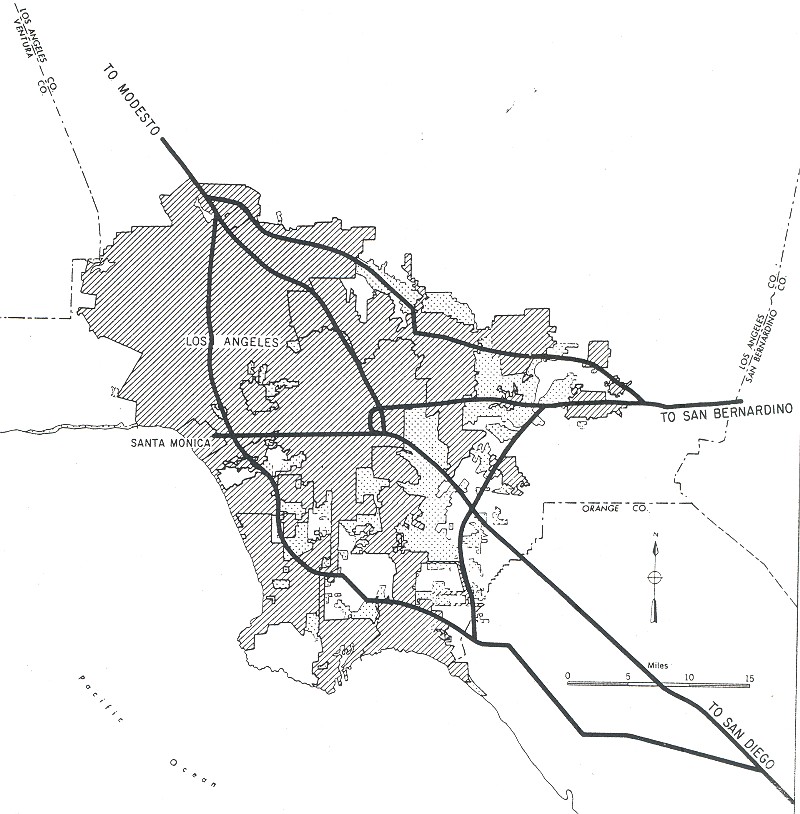
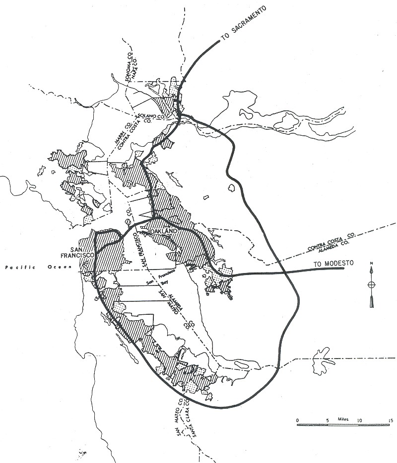
Note: The original plans (without numbers) for the major cities can be found here: Los Angeles, San Francisco
| Route | Description | Route Status | Number Status | |
|---|---|---|---|---|
| I-102 | Santa Monica to I-5, Los Angeles | Approved | 14-Aug-1957 | I-10 Tentatively Approved |
| 05-Dec-1957 | Proposed as I-12 | |||
| 07-Aug-1958 | Back to I-10 | |||
| 10-Nov-1958 | Approved as I-10 | |||
| I-2106 | I-5 to I-10 in Los Angeles | Approved | 08-Nov-1957 | Proposed as I-12 |
| 05-Dec-1957 | Proposed as I-14 | |||
| 01-Apr-1958 | Proposed as I-102 | |||
| 07-Aug-1958 | Proposed as I-210 | |||
| 10-Nov-1958 | Approved as I-210 | |||
| I-2807,8 | San Jose to San Francisco | Approved | 08-Nov-1957 | Proposed as I-3 |
| 01-Apr-1958 | Proposed as I-109 | |||
| 07-Aug-1958 | Proposed as I-180 | |||
| 10-Nov-1958 | Approved as I-280 | |||
| I-4056 | El Toro to San Fernando | Approved | 08-Nov-1957 | Proposed as I-9 |
| 01-Apr-1958 | Proposed as I-3 | |||
| 07-Aug-1958 | Proposed as I-405 | |||
| 10-Nov-1958 | Approved as I-405 | |||
| I-4807,9 | Route 80 to US 101 in San Francisco | Approved (Later Deleted) |
08-Nov-1957 | Number Unknown |
| 01-Apr-1958 | Proposed as I-110 | |||
| 07-Aug-1958 | Proposed as I-380 | |||
| 10-Nov-1958 | Approved as I-480 | |||
| I-6056 | I-405 to I-10 in Los Angeles | Approved | 08-Nov-1957 | Proposed as I-13 |
| 01-Apr-1958 | Proposed as I-105 | |||
| 07-Aug-1958 | Proposed as I-605 | |||
| 10-Nov-1958 | Approved as I-605 | |||
| I-6806 | San Jose to Vallejo San Jose Adjustment: October 1964 |
Approved | 08-Nov-1957 | Proposed as I-5 |
| 01-Apr-1958 | Proposed as I-113 | |||
| 07-Aug-1958 | Proposed as I-580 | |||
| 10-Nov-1958 | Approved as I-680 | |||
| I-7806 | Portion of I-680 Number revised: July 1973 |
Approved | Jul 1973 | Approved as I-780 |
| TOTAL MILEAGE FOR 1955 ADDITIONS AND PRIOR LINE ADJUSTMENTS: | 197 | |||
| TOTAL MILEAGE AS OF 9/15/1955: | 2,135 | |||
Footnotes:
| Route | Description | Status |
|---|---|---|
| Route 37 US 101 |
San Francisco to Vallejo via Sears Point, 40 mi | Not Approved |
| Route 5810 | I-5, Bakersfield to Barstow, 145 mi | Not Approved |
| Route 86 | El Centro to Indio, 84 mi | Not Approved |
Footnotes:
| Route | Route Description | Route Status | Number Status | |
|---|---|---|---|---|
| I-205 | North Tracy Bypass | Approved | 8-Nov-1957 | Number Unknown |
| 1-Apr-1958 | Proposed as I-112 | |||
| 7-Aug-1958 | Proposed as I-205 | |||
| 10-Nov-1958 | Approved as I-205 | |||
| Route | Description | Status |
|---|---|---|
| Route 143 Route 14811 |
Sacramento South and East Belt Route, 23 mi | Not Approved |
Footnotes:
| Route | Route Description | Route Status | Number Status | |
|---|---|---|---|---|
| I-805 | San Diego belt route | Approved | 6-Nov-1958 | Submitted as I-805 |
| 10-Nov-1958 | Approved as I-805 | |||
| I-880 | Sacramento Belt Route (Present-day I-80) |
Approved | 6-Nov-1958 | Submitted as I-880 |
| 10-Nov-1958 | Approved as I-880 | |||
| 1980 | Renumbered as I-80 | |||
| Route 143 Route 14811 |
Sacramento South and East Belt Route, 23 mi | Not Approved | ||
| TOTAL MILEAGE FOR 1958 ADDITIONS AND 1957 LINE ADJUSTMENTS: | 42 | |||
| TOTAL MILEAGE AS OF JULY 1958: | 2,177 | |||
Footnotes:
| Route | Description | Route Status | Number Status | |
|---|---|---|---|---|
| I-28012 | Reroute in San Francisco | Approved +2.1 miles |
No Number Changes | |
| I-8 | Adjustment E of San Diego | Approved -1.8 miles |
No Number Changes | |
| I-8012 | Delete westerly of Route 280 in San Francisco | Approved -5.3 miles |
No Number Changes | |
| I-10512 | Delete (portion) in
Central L.A. (now part of US 101) |
Approved -1.3 miles |
1-Apr-1958 | Proposed as I-106 |
| 7-Aug-1958 | Proposed as I-105 | |||
| 10-Nov-1958 | Approved as I-105 | |||
| I-11012 | Delete (portion) in
Central L.A. (now part of I-5) |
Approved -0.7 miles |
1-Apr-1958 | Proposed as I-106 |
| 7-Aug-1958 | Proposed as I-110 | |||
| 10-Nov-1958 | Approved as I-110 | |||
| I-48012 | Delete entire Route in San Francisco | Approved -5.5 miles |
No Number Changes | |
| TOTAL MILEAGE FOR 1965 ADJUSTMENTS: | -12.5 | |||
| TOTAL MILEAGE AS OF AUGUST 1965: | 2,165 | |||
Footnotes:
| Route | Description | Status |
|---|---|---|
| I-10512 | Century Freeway (includes 7.0 miles Howard-Cramer, 10 mi from San Francisco) |
Approved |
| TOTAL MILEAGE FOR MARCH 1968
ADDITIONS: (*: Includes 7.0 miles "Howard-Cramer") |
*17 | |
| TOTAL MILEAGE AS OF MARCH 1968: (*: Includes 7.0 miles "Howard-Cramer") |
*2,182 | |
Footnotes:
| Route | Description | Status |
|---|---|---|
| Route 3013 | I-210 to I-15, San Dimas to Etiwanda, 19.2 mi | Not Approved (1970) |
| Route 50 | Sacramento to Nevada, 99.9 mi | Not Approved (1970) |
| Route 5810 | I-5, Bakersfield to Barstow, 145 mi | Not Approved (1970) |
| Route 23814 | Fremont to Hayward, 15.2 mi | Not Approved (1970) |
| Southern Crossing of San Francisco Bay and Approaches, 25 mi | Not Approved |
Footnotes:
1,500 mile addition, 1968 Federal Aid Highway Act
| Route | Description | Status | Mileage |
|---|---|---|---|
| I-1515 | I-8 to I-10, San Diego to San Bernardino ($201,200,000) | Approved | 102.5 |
| Corona-Norco adjustment N of Temecula to Devore: February 1972. This may be the San Bernardino West Bypass, the 14.2 mi segment that was pending in 1970. | |||
| I-38016 | I-280 to San Francisco International Airport ($31,200,000). | Approved | 1.6 |
| I-60517 | Extension I-10 to I-210 ($19,000,000) | Approved | 5.5 |
| TOTAL MILEAGE FOR DECEMBER 1968 ADDITIONS AND LINE ADJUSTMENTS: | 112 | ||
| TOTAL MILEAGE AS OF DECEMBER
1968: (*: Includes 7.0 miles "Howard-Cramer") |
*2,294 | ||
Footnotes:
| Route | Description | Status |
|---|---|---|
| I-980 | Route 17 (now I-880) to I-580 in Oakland | Approved |
| TOTAL MILEAGE FOR 1976 ADDITIONS: | 1 | |
| TOTAL MILEAGE AS OF JANUARY
1976: (*: Includes 7.0 miles "Howard-Cramer") |
*2,295 | |
| Route | Description | Status |
|---|---|---|
| I-180 | I-80 in Albany to Richmond-San Rafael Bridge Number changed to I-580 in June 1983 |
Approved |
| TOTAL MILEAGE FOR APRIL 1978 ADDITIONS: | 6 | |
| TOTAL MILEAGE AS OF APRIL 1978: (*: Includes 7.0 miles "Howard-Cramer") |
*2,301 | |
| Route | Description | Status |
|---|---|---|
| I-15 | Mileage correction in Lake Elsinore Area | Approved |
| TOTAL MILEAGE FOR JULY 1978 ADJUSTMENTS: | -1 | |
| TOTAL MILEAGE AS OF JULY 1978: (*: Includes 7.0 miles "Howard-Cramer") |
*2,300 | |
| Route | Description | Status |
|---|---|---|
| I-11018 | Route 47 in San Pedro to I-10 in Los Angeles | Approved |
| TOTAL MILEAGE FOR DECEMBER 1978 ADDITIONS: | 20 | |
| TOTAL MILEAGE AS OF DECEMBER
1978: (*: Includes 7.0 miles "Howard-Cramer") |
*2,320 | |
Footnotes:
| Route | Description | Status |
|---|---|---|
| I-80 | Withdrawal of segment in Sacramento Route 80/99/50 interchange to (former) I-880 near Watt Avenue |
Approved |
| I-305 | A 5.3 mi segment of existing I-80 from (former) I-880 (i.e., the current I-80/US 50 interchange) to US 50 (i.e., the current US 50/Route 99/Business Route 80 (Route 51) interchange) was redesignated as I-305. This is currently signed as US 50, as well as part of Business Route 80. | Approved |
| TOTAL MILEAGE FOR MAY 1980 ADDITIONS AND LINE ADJUSTMENTS: | -7 | |
| TOTAL MILEAGE AS OF MAY 1980: (*: Includes 7.0 miles "Howard-Cramer") |
*2,313 | |
| Route | Description | Status |
|---|---|---|
| I-280 | Withdrawal of segment in San Francisco 6th Street to San Francisco and Oakland Bay Bridge |
Approved |
| TOTAL MILEAGE FOR 1981 LINE ADJUSTMENTS: | -2 | |
| TOTAL MILEAGE AS OF JANUARY
1981: (*: Includes 7.0 miles "Howard-Cramer") |
*2,311 | |
| Route | Description | Status |
|---|---|---|
| I-210 | Eliminate I-210 from (former) Route 30 to I-10 (Pomona); New routing of I-210 along (former) Route 30 to I-15 to I-10, San Dimas to Redlands, 42.5 mi | Submitted, but deferred on 11/6/98 |
| Route | Description | Status |
|---|---|---|
| I-210 | Eliminate I-210 from (former) Route 30 to I-10 (Pomona); New routing of I-210 along (former) Route 30 to I-15 to I-10, San Dimas to Redlands, 42.5 mi | Submitted 3/9/99, then
withdrawn 3/22/99 |
❦
23 USC 139 23 USC 103(c)(4) of the US Code allows
for the designation of certain highways as Interstate routes in addition
to those that count against the authorized total mileage of the Interstate system. These highways are not eligible for regular Interstate Completion
funds and are colloquially called "Non-chargeable Interstates". They are
all functionally classified as Interstate. They are signed as interstates
to provide continuity and connectivity for motorists and truckers. There
are two types:
Note that the section numbers have changed. According to the FHWA log:
The FHWA may, at the request of a State or States, designate sections of the National Highway System (NHS) as Interstate Highway under Section 103(c)(4)(A), Title 23, United States Code (23 U.S.C.). The proposed section must:
- Be built to Interstate standards and
- Be a logical addition to the System.
Although Section 103(c)(4)(A) segments look like any other Interstate highway, they are not eligible for development with Interstate Completion funds.
Also added to the Interstate System under Section 103(c)(4)(A) are highways in Alaska and Puerto Rico for a total of 1,331.99 miles
(including additions under former Section 139(c)). Alaska and Puerto Rico are exempt from the design standards of Section 109(b). Section 103(c)(1)(B)(ii), 23 U.S.C., states: "Highways on the Interstate System in Alaska and Puerto Rico shall be designed in accordance with such geometric and construction standards as are adequate for current and probable future traffic demands and the needs of the locality of the highway."The FHWA may also, at the request of a State or States, add highways to the Interstate System that are designated as National Highway System (NHS) high priority corridors and future parts of the Interstate System in Section 1105 of the Intermodal Surface Transportation Efficiency Act of 1991 (ISTEA). The proposed section must:
- Be built to Interstate standards and
- Connect with an existing Interstate route.
The following is a summary of California's non-chargeable interstate mileage:
| Route | Description ( |
Miles | Miles Per FHWA Log |
|---|---|---|---|
| I-215 | Temecula to Devore (6.2 mi is still |
60.20 | 54.50 |
| I-238 | Between I-580 and Route 17 in San Leandro. | 2.0 | 2.23 |
| I-680 | Between Benicia and Cordelia. | 12.0 | 12.50 |
| I-580 | Castro Street in Richmond to US 101 in San Rafael | 7.0 | 7.30 |
| I-710 | Ocean Blvd in Long Beach to I-10 (1.6 mi
is still |
21.6 | 19.66 |
| I-880 | San Jose to I-80 | 45.0 | 47.22 |
| I-905 | Route 117/125 from I-5 to the Mexico
border |
8.80 | 0.0 |
| I-980 | The constructed freeway portion of I-980 between I-580 and 1 mi S, | 1.0 | 1.00 |
| TOTAL | 158.0 | 144.41 | |
The following is a chronology of California's non-chargeable interstate routes:
| Route | Description | 139(a) Miles | 139(b) Miles |
|---|---|---|---|
| Route 215 | The alignment of I-15 between Temecula and Devore was shifted westerly to a location via Corono-Norco. Existing completed I-15 Freeway in San Bernardino between I-10 and Devore was redesignated as I-215 (changed to I-15E in April 1973, and back to I-215 in June 1982) | 14 | 0 |
| TOTAL MILEAGE AS OF FEBRUARY 1972: | 14 | 0 | |
| Route | Description | 139(a) Miles | 139(b) Miles |
|---|---|---|---|
| Route 215 | The FHA approved future I-15E
(changed to I-215, June 1982) as non-chargeable mileage
between Route 60 and I-15.
(This has since been constructed and is now |
0 | 29 |
| TOTAL MILEAGE AS OF OCTOBER 1972: | 14 | 29 | |
| Route | Description | 139(a) Miles | 139(b) Miles |
|---|---|---|---|
| Route 680 | Between Benicia and Cordelia. The basis for this change was continuity for the public. The existing I-680 segment between Benicia and Vallejo was renumbered to I-780. | 12 | 0 |
| TOTAL MILEAGE AS OF JULY 1973: | 26 | 29 | |
| Route | Description | 139(a) Miles | 139(b) Miles |
|---|---|---|---|
| Route 215 | Between I-10 and Route 60. Approved as I-15E, changed to I-215, June 1982 | 11 | 0 |
| TOTAL MILEAGE AS OF DECEMBER 1973: | 37 | 29 | |
| Route | Description | 139(a) Miles | 139(b) Miles |
|---|---|---|---|
| Route 980 | The constructed freeway portion of I-980 between I-580 and 1 mi S was approved as non-chargeable interstate. The remaining unconstructed 0.8 mi segment to I-880 was approved for chargeable interstate funding. | 1 | 0 |
| TOTAL MILEAGE AS OF JANUARY 1976: | 38 | 29 | |
| Route | Description | 139(a) Miles | 139(b) Miles |
|---|---|---|---|
| Route 580 | The constructed portion of Route 17 (now I-580) between Castro Street in Richmond and US 101 in San Rafael was added as I-180, changed to I-580 in July 1983. | 7 | 0 |
| TOTAL MILEAGE AS OF APRIL 1978: | 45 | 29 | |
| Route | Description | 139(a) Miles | 139(b) Miles |
|---|---|---|---|
| Route 880 | The Nimitz Freeway (Route 17) between San Jose and I-80 at the San Francisco. Designation of I-880 approved by AASHTO on July 7, 1983. | 45 | 0 |
| Route 238 | Between I-580 and Route 17 in San Leandro. Designation of I-238 approved by AASHTO on July 7, 1983. | 2 | 0 |
| TOTAL MILEAGE AS OF MAY 1983: | 92 | 29 | |
| Route | Description | 139(a) Miles | 139(b) Miles |
|---|---|---|---|
| Route 710 | Route 7 between Route 1 and I-10. I-710 approved by AASHTO on 5/30/1984. | 20 | 0 |
| TOTAL MILEAGE AS OF SEPTEMBER 1983: | 112 | 29 | |
| Route | Description | 139(a) Miles | 139(b) Miles |
|---|---|---|---|
| Requests for six routes totaling 47 mi were forwarded for approval as non-chargeable interstate. One Route (US 101/I-80 in San Francisco) was not approved, leaving five under consideration as of 10/1/1984. | 0 | 0 | |
| Route | Description | 139(a) Miles | 139(b) Miles |
|---|---|---|---|
| Route 710 | Ocean Blvd in Long Beach to Route 1 | 0 | 1.6 |
| Route 15 | I-5 to I-8 in San Diego | 0 | 6.2 |
| Route 905 | Route 117/125 from I-5 to the Mexico border | 0 | 8.8 |
| Route 4 | Pinole and West Pittsburg in Contra Costa County | Not Approved | |
| Route 113 | Between Davis and Woodland in Yolo County | Not Approved | |
| TOTAL MILEAGE AS OF OCTOBER 1984: | 112 | 46 | |
 Control Cities
  Return to Interstate Highway Types
© 1996-2024 Daniel P.
Faigin.
Maintained by: Daniel P. Faigin <webmaster@cahighways.org>.