
 California Highways:
 In 1933, the Legislature amended the State Highway Classification Act of 1927 with Chapter 767 of the 1933 Statutes (PDF, 173 MB), adding 6,700 mi of county roads to the State Highway System (all classified as secondary highways). Highway construction funds were allocated equally between primary and secondary highways. The legislative barrier that prevented state highway funds from being used in urban areas was removed. 1933 also saw the creation of an eleventh district, with headquarters in San Diego.
Note: It is difficult to relate the specific text in the 1933 act with the routings today. Text shown in light purple represents the closest equivalent to current routings, if it could be identified. For more specifics, please visit the appropriate page for the route or LRN in question (information for the LRN is always at the end of a given route's entry page).
| LRN | First Signage | Other Signage | Present Route (R) and Signage (S) | Action | Segment |
|---|---|---|---|---|---|
| LRN 2 | US 101 | CA 135 | Reroute | Orcutt to [LRN 2] S of Santa
Maria Route 1 near Orcutt to Santa Maria |
|
| US 101 | CA 135 | Reroute | Harris to [LRN 2] near Los
Alamos Route 1 near Vandenberg AFB to Los Alamos |
||
| LRN 5 | CA 8 | CA 26 | Extend | [LRN 4] near Stockton to
[LRN 65] near Mokelumne Hill Route 4 to Mokelumne Hill |
|
| LRN 6 | CA 37 | CA 121, CA 221 | Extend | ¹[LRN 8] near Napa to
Winters via Wooden Valley and Berryessa Valley Route 29 to Route 128/Route 121 junction |
|
| CA 128 | CA 128 | Extend | ²[LRN 8] near Napa to
Winters via Wooden Valley and Berryessa Valley Route 121/Route 128 junction to I-505 |
||
| LRN 9 | CA 118 | None | Extend | ¹[LRN 2] near Montalvo
to [LRN 4] near San Fernando US 101 near Montalvo to Saticoy Note: This may have been Vicoria and Telephone Road |
|
| CA 118 | CA 118 | Extend | ²[LRN 2] near Montalvo
to [LRN 4] near San Fernando Route 232 near Saticoy to I-5 (former US 99) near San Fernando |
||
| LRN 11 | CA 24 | CA 160 | Extend | Walnut Creek-Stockton Road
near Antioch to Sacramento Antioch to Sacramento |
|
| LRN 12 | US 80 | CA 209 | Extend | [LRN 2], Atlantic Street,
San Diego to old Spanish Lighthouse, Point Loma Cabrillo National Monument to US 101 |
|
| LRN 20 | CA 44 | CA 440 | CA 44 | Extend | [LRN 28] near Redding to
Lassen National Park Redding to Lassen National Park |
| LRN 22 | CA 156 | CA 156 | Extend | Coast Road near Castroville
to [LRN 2] near Prunedale Route 1 near Castroville to US 101 |
|
| CA 156 | CA 156 | Extend | [LRN 22] near San Juan
Bautista to [LRN 2] near The Rocks US 101 to San Juan Bautista |
||
| LRN 24 | CA 4 CA 8 |
CA 88 | CA 88 | Extend | [LRN 23] near Woodfords to
the California-Nevada state line Route 89 to Nevada state line |
| LRN 25 | CA 174 | CA 174 | Extend | [LRN 37] near Colfax to [LRN 17] near Grass Valley I-80 near Colfax to Route 20 near Grass Valley |
|
| CA 49 | CA 49 | Extend | [LRN 25] at Downieville to
Blairsden-Truckee Road near Sattley Downieville to Route 89 |
||
| LRN 26 | US 70 | US 99 | I-10 | Extend | Los Angeles (Aliso Street)
to [LRN 26] near Monterey Park via Ramona Blvd US 101 to Monterey Park |
| LRN 29 | CA 36 | CA 36 | Extend | [LRN 35] to [LRN 3] near Red
Bluff Route 3 to I-5 (former US 99) |
|
| LRN 31 | US 91 | US 91 | I-15 | Extend | [LRN 26] near Colton to [LRN 9] near San Bernardino via Mt. Vernon Ave I-10 to US 66 |
| LRN 32 | CA 152 | CA 152 | Extend | Coast Road near Watsonville
to [LRN 2] in Santa Clara Valley via Hecker Pass Route 1 to US 101 |
|
| LRN 33 | CA 41 | CA 46 | Extend | [LRN 56] near Cambria to
[LRN 2] near Paso Robles Route 1 to US 101 |
|
| LRN 35 | CA 36 | CA 36 | Define | [LRN 1] near Alton to [LRN 35] near Kuntz US 101 near Alton to Peanut (see note) |
|
| CA 3 | CA 3 | Define | [LRN 35] near Peanut to [LRN 20] near Douglas City Peanut to Douglas City |
||
| LRN 40 | CA 120 | None | Extend | [LRN 23] near Mono Lake to
[LRN 76] near Benton Station US 395 to US 6 |
|
| LRN 41 | CA 180 | CA 180 | Extend | [LRN 4] near Fresno to
General Grant National Park Fresno to General Grant Grove 1[LRN 4] near Fresno to [LRN 5] near Tracy Route 33 near Mendota to Fresno |
|
| CA 33 | CA 33 | Extend | 2[LRN 4] near Fresno to [LRN 5] near Tracy Route 180 in Mendota to Route 152 near Los Banos |
||
| CA 33 | None | Extend | 3[LRN 4] near Fresno to [LRN 5] near Tracy Route 152 near Los Banos to 6 mi NW of Volta to near the present I-5 |
||
| CA 33 | CA 33 | Extend | 4[LRN 4] near Fresno to [LRN 5] near Tracy I-5 (formerly, LRN 121) to Route 140 |
||
| CA 33 | CA 33 | Extend | 5[LRN 4] near Fresno to [LRN 5] near Tracy Route 140 to I-5 near Vernalis |
||
| CA 33 | None | Extend | 6[LRN 4] near Fresno to [LRN 5] near Tracy I-5 to I-205 |
||
| LRN 42 | CA 9 | CA 9 | Extend | [LRN 55] near Saratoga Gap
to [LRN 5] near Los Gatos Saratoga to Route 17 in Los Gatos (Original Route 9 signage diverged to LRN 114) |
|
| LRN 43 | CA 18 | CA 18 | Extend | [LRN 31] from Victorville to
[LRN 43] near Big Bear Lake via Baldwin Lake A highway around Big Bear Lake connecting [LRN 43] Big Bear Lake (Southern route) to I-15 (US 91) |
|
| LRN 47 | CA 32 | CA 32 | Extend | [LRN 3] near Chico to [LRN 29] near Deer Creek Meadows Chico to Route 36 |
|
| LRN 49 | CA 29 | CA 29 | Extend | [LRN 8] near Napa to [LRN 49] near Calistoga Route 121 in Napa to Route 29 in Calistoga |
| LRN 50 | CA 16 | CA 16 | Extend | [LRN 50] near Rumsey to [LRN 7] near Woodland Woodland to Sacramento Rumsey to Sacramento via Woodland |
|
| LRN 51 | CA 12 | CA 12 | Extend | Sebastopol to [LRN 1] near
Santa Rosa Route 116 near Sebastopol to US 101 |
|
| LRN 54 | CA 16 | CA 16 | Define | [LRN 11] near Perkins to
[LRN 54] near Michigan Bar Sacramento (US 50) to the county line near Michigan Bar |
|
| LRN 56 | CA 1 | CA 1 | Extend | [LRN 2] near Las Cruces via
Lompoc and Guadalupe to [LRN 2] near Pismo Las Cruces to Pismo Beach |
|
| CA 1 | CA 1; I-280 | Extend | [LRN 56] near Carmel to
Santa Cruz Carmel to Santa Cruz Santa Cruz to San Francisco via Coast Santa Cruz to US 101 in San Francisco State Highway near the Southerly end of the Marin Peninsula to the Marin-Sonoma County Line via the Coast Route US 101 on the Marin Peninsula to Marin-Sonoma County line Russian River near Jenner to Westport Jenner to Westport |
||
| CA 1 | CA 211 | Extend | Ferndale to [LRN 1] near Fernbridge Route 1 near Rockport to US 101 near Fernbridge |
||
| LRN 58 | CA 178 | CA 58 | Extend | [LRN 2] near Santa Margarita
to [LRN 4] near Bakersfield US 101 to Route 99 in Bakersfield |
|
| LRN 59 | CA 138 | CA 138 | Extend | ¹[LRN 31] near Cajon
Pass to [LRN 43] via Lake Arrowhead I-15 to Route 173 |
|
| CA 173 | CA 173 | ¹[LRN 31] near Cajon
Pass to [LRN 43] via Lake Arrowhead Route 173 to Route 18 via Lake Arrowhead |
|||
| LRN 61 | CA 2 | None | Extend | ¹San Fernando Road to
[LRN 9] via Verdugo Road San Fernando Road to Avenue 36 via Eagle Rock Boulevard Note that this routing was deleted in 1957 (Chapter 1911) |
|
| LRN 61 | CA 2 | CA 2 | Extend | ²San Fernando Road to
[LRN 9] via Verdugo Road Avenue 36 (Fletcher Dr) in Glendale to I-210 (Route 118) |
|
| LRN 61 | CA 2 | CA 2 | Extend | [LRN 61] to [LRN 59] via Los
Angeles County Park Route 39 to Route 138 |
|
| LRN 62 | CA 39 | CA 39 | Extend | ¹Huntington
Beach-Whitter Road near Buena Park to [LRN 9] near Azuza US 101 (freeway routing) to Route 72 (former US 101 surface routing) |
|
| CA 39 | CA 39 | Extend | ²Huntington
Beach-Whitter Road near Buena Park to [LRN 9] near Azuza Whittier Blvd in La Habra to Azusa |
||
| LRN 64 | CA 74 | CA 74 | Extend | [LRN 2] near San Juan
Capistrano to [LRN 77] near Lake Elsinore I-5 near San Juan Capistrano to I-15 near Lake Elsinore |
|
| CA 740 | CA 74 | CA 74 | Extend | [LRN 78] near Perris to [LRN 26] near Indio I-215 near Perris to I-10 near Thousand Palms |
|
| LRN 65 | CA 49 | CA 49 | Extend | [LRN 40] near Moccasin Creek
to [LRN 18] near Mariposa Route 140 at Mariposa to Route 120/Route 108 near Moccasin |
|
| CA 49 | CA 49 | Extend | [LRN 11] near El Dorado to
[LRN 11] near Placerville via Diamond Springs El Dorado to Placerville |
||
| LRN 66 | CA 120 | CA 120 | Extend | [LRN 4] near Manteca to [LRN 13] near Oakdale Route 99 to Route 108 near Oakdale |
|
| LRN 67 | CA 129 | CA 129 | Extend | [LRN 67] near Chittenden to
the Coast Road near Watsonville Route 129 near Chittenden to Route 1 near Watsonville |
|
| LRN 69 | CA 17 | CA 112, CA 61, CA 260 | I-880 | Extend | San Jose to Richmond (East
Shore Highway) US 101 to I-80 (US 40/US 50) |
| LRN 73 | US 395 | US 395 | Extend | [LRN 28] at Alturas to [LRN 29] Route 36 to Alturas |
| LRN 75 | CA 21 | I-680 | Extend | 1[LRN 75] near Walnut Creek to [LRN 5] near Stockton via Antioch Route 24 near Walnut Creek to I-780 near Benecia |
|
| CA 24 | CA 242 | Define | 2[LRN 75] near Walnut Creek to [LRN 5] near Stockton via Antioch I-680 near Pleasant Hill to Route 4 N of Concord |
||
| CA 24 | CA 4 | CA 4 | Define | 3[LRN 75] near Walnut Creek to [LRN 5] near Stockton via Antioch Route 242 N of Concord to Antioch |
|
| CA 4 | CA 4 | Define | 4[LRN 75] near Walnut Creek to [LRN 5] near Stockton via Antioch Antioch to Stockton [LRN 4] near Stockton to [LRN 65] near Altaville Stockton to Altaville |
||
| LRN 76 | CA 168 | CA 168 | Define | Fresno-Yosemite Road at Shaw
Avenue to Huntington Lake Route 41 near Fresno to Huntington Lake |
|
| CA 168 | CA 168 | Define | [LRN 23] to Camp Sabrina Camp Sabrina to US 395 |
||
| LRN 78 | CA 79 | CA 79 | Define | ¹[LRN 12] near Descanso
to [LRN 77] near Temecula I-8 to Route 79 near Aguanga |
|
| CA 71 | CA 79 | Define | ²[LRN 12] near Descanso
to [LRN 77] near Temecula Route 79 near Aguanga and I-15 near Temecula |
||
| LRN 80 | CA 150 | CA 144 | Define | ¹[LRN 80] to [LRN 2]
via Foothill Road US 101 to Route 192 via Sycamore Canyon |
|
| CA 150 | CA 192 | Define | ²[LRN 80] to [LRN 2]
via Foothill Road Route 154 near Santa Barbara to Route 144 |
||
| CA 150 | CA 192 | Define | Santa Barbara to
Rincon-Santa Paula Road near Ventura-Santa Barbara County Line Route 144 in Santa Barbara to Route 150 near Rincon |
||
| LRN 81 | CA 197 | CA 197 | Define | [LRN 71] to [LRN 1] N of
Smith River US 101 to US 199, staying N of the Smith River |
|
| LRN 82 | CA 3 | CA 3 | Define | Etna Mills to Montague Etna (near I-5) to Montague |
|
| LRN 83 | CA 89 | CA 89 | Define | [LRN 3] near Mt. Shasta to
Lassen National Park From I-5 near Mount Shasta to Lassen National Park |
|
| CA 89 | CA 89 | Define | Lassen National Park to [LRN 29] at Mineral Route 89 near Lassen National Park to Route 36 near Deer Creek Pass |
||
| CA 36 | CA 36 CA 89 |
Define | ²Lassen National
Park-Mineral Road to [LRN 29] near Morgan Route 36/Route 89 junction near Deer Creek Pass to Morgan Springs |
||
| CA 89 | CA 89 | Define | [LRN 29] near Deer Creek
Pass to [LRN 21] near Indian Falls Route 36 near Chester to Route 70 |
||
| US 40A | CA 89 | CA 89 | Define | ¹[LRN 21] near
Blairsden to [LRN 38] near Truckee Route 70 to Route 49 |
|
| CA 89 | CA 89 | Define | ²[LRN 21] near
Blairsden to [LRN 38] near Truckee Route 49 to I-80 |
||
| LRN 84 | CA 96 | CA 96 | Define | [LRN 20] near Willow Creek
to [LRN 46] near Weitchpec US 299 near Willow Creek to Weitchpec |
|
| LRN 85 | CA 200 | CA 200 | Define | [LRN 1] to [LRN 20] N of Mad
River US 101 to US 299 N of the Mad River |
|
| LRN 86 | CA 36 | CA 36 | Define | ¹Lassen National
Park-Mineral Road to [LRN 29] near Morgan Route 36 near Mineral to the Route 36/Route 89 junction near Deer Creek Pass |
|
| LRN 87 | CA 113 | CA 113 | Define | [LRN 7] near Woodland to
State Highway near Yuba City I-5 to Route 99 |
|
| CA 24 | US 40A | CA 70 | Define | [LRN 15] near Marysville to
[LRN 21] near Oroville Route 70/Route 20 junction near Marysville to Route 162 near Oroville |
|
| CA 149 | CA 149 | Define | [LRN 3] near Chico to [LRN 21] near Oroville Route 70 near Wick's Corners to Route 99 near Chico |
||
| LRN 88 | CA 45 | CA 45 | Define | [LRN 15] near Sycamore to
Woodland-Yuba City Road near Knights Landing Route 113 near Knights Landing to Route 20 near Sycamore |
|
| CA 45 | CA 45 | Define | [LRN 45] near Glenn to [LRN 47] near Hamilton City Route 20 near Colusa to Route 32 near Hamilton City |
||
| LRN 89 | CA 29 | CA 29 | Define | ¹[LRN 49] near
Middletown to [LRN 15] near Upper Lake via Lakeport Route 20 to Route 175 6 mi NE of Kelseyville |
|
| CA 29 | CA 29 CA 175 |
Define | ²[LRN 49] near
Middletown to [LRN 15] near Upper Lake via Lakeport Route 29/Route 175 junction 4 mi SE of Kelseyville to Route 29/Route 175 junction 6 mi NW of Kelseyville |
||
| CA 29 | CA 175 | Define | ³[LRN 49] near
Middletown to [LRN 15] near Upper Lake via Lakeport Route 29 (S Junction) to Route 29 (Middletown) |
||
| LRN 90 | I-505 | I-505 | Define | [LRN 7] near Vacaville to
[LRN 7] near Dunnigan I-80 near Vacaville to I-5 near Dunnigan |
|
| LRN 91 | US 99E | CA 193 | CA 193 | Define | [LRN 3] near Lincoln to [LRN 17] near Newcastle Route 65 near Lincoln to I-80 near Newcastle |
| LRN 92 | CA 153 | CA 153 | Define | [LRN 65] near Coloma to
Marshall's Monument Route 49 near Columa to Marshall's Monument |
|
| LRN 93 | CA 193 | CA 193 | Define | [LRN 65] near Cool via
Georgetown to [LRN 65] near Placerville Route 49 near Cool to Route 49 near Placerville |
|
| LRN 94 | CA 188 | None | Define | [LRN 38] near Camp
Richardson to S end Fallen Leaf Lake Route 89 near Camp Richardson to the S end of Fallen Leaf Lake |
|
| LRN 95 | CA 7 | US 395 | Define | [LRN 23] near Coleville to
the California-Nevada state line Route 89 to Nevada state line near Topaz |
|
| LRN 96 | CA 182 | CA 182 | Define | [LRN 23] near Bridgeport to
the California-Nevada state line via Walker River US 395 near Bridgeport to the Nevada state line |
|
| LRN 97 | CA 88 | CA 88 | Define | ¹[LRN 4] near Stockton
to [LRN 54] near Waite's Station Route 99 near Stockton to Route 88/Route 49 junction S of Ione |
|
| CA 124 | CA 124 | Define | ²[LRN 4] near Stockton
to [LRN 54] near Waite's Station Route 88 S of Ione to Route 16 near Waits Station |
||
| LRN 98 | US 50/US 99E | CA 51/R Business Route 80/S |
Define | [LRN 4] S of Sacramento to
[LRN 3] near Ben Ali US 50/Route 99 junction to Route 160. H Street Bridge. |
|
| LRN 99 | CA 84 | CA 84 | Define | [LRN 53] at Rio Vista via
Ryer Island to [LRN 6] near Broderick Route 12 at Rio Vista to US 50 |
| LRN 100 | CA 220 | CA 220 | Define | Rio Vista-Broderick Road on
Ryer Island to Sacramento-Antioch Road Route 84 on Ryer Island to Route 160 |
|
| LRN 101 | CA 113 | CA 113 | Define | [LRN 53] to [LRN 7] near
Dixon Route 12 to I-80 near Dixon |
|
| LRN 102 | CA 128 | CA 128 | Define | Napa-Calistoga Road near
Rutherford to Napa-Winters Road via Sage Canyon Route 29/Route 121/Route 128 junction near Rutherford to Route 121 (Steele Canyon Road) |
|
| LRN 103 | CA 28 | CA 128 | Extend | Calistoga to [LRN 1] near
Geyserville US 101 near Calistoga to Route 29 near Geyserville |
|
| LRN 104 | CA 12 | CA 116 | Define | ¹Coast Road near Jenner
to [LRN 1] near Cotati Route 1 to Route 116 near Sebastopol |
|
| Unknown | CA 116 | Define | ²Coast Road near Jenner
to [LRN 1] near Cotati Route 116 near Sebastopol to US 101 |
||
| Unknown | CA 116 | Define | [LRN 1] near Petaluma to
[LRN 8] near Shellville US 101 near Petaluma to Route 121 near Shellville |
||
| Unknown | I-80 | Extend | [LRN 8] to [LRN 7] through
American Canyon Route 29 near Vallejo to Route 12 near Cordelia Note: This segment was replaced by a new routing for LRN 7 in 1935, which filled a previous gap in LRN 7 between Benecia and the N end of the bridge. This was captured in the 1937 code. |
||
| LRN 105 | CA 92 | CA 92 | Define | Coast Road near Half Moon
Bay to [LRN 2] near San Mateo Route 1 near Half Moon Bay to I-280 |
|
| CA 92 | CA 92 | Define | San Jose-Richmond East Shore
Highway near Mt. Eden to [LRN 5] near Hayward I-880 to Route 238 |
||
| CA 17 | CA 185 | Define | Hayward, via Fourteenth
Street in San Leandro to Seventh and Cypress Streets in Oakland Route 238 to Route 77 in Oakland |
||
| LRN 106 | CA 4 | CA 4 | Define | [LRN 14] near Hercules to
the Walnut Creek-Antioch Road I-80 (former US 40) to Route 242 N of Concord |
|
| LRN 107 | CA 84 | CA 84 | Define | [LRN 55] to [LRN 2] near
Menlo Park Route 35 to US 101 |
|
| CA 114 | CA 84 | Define | [LRN 55] to [LRN 2] near
Menlo Park US 101 N of Atherton to Route 84 |
||
| CA 84 | CA 84 | Define | San Jose-Richmond East Shore
Highway near Newark to Walnut Creek-Scotts Corners Road near Sunol Route 84 near Menlo Park to Route 84 near Sunol |
||
| CA 21 | I-680 | Define | [LRN 75] near Walnut Creek
to Livermore-San Jose Mission Road near Scotts Corners Route 84 near Sunol to Route 24 near Walnut Creek |
||
| LRN 108 | CA 21 | I-680 | Define | ¹[LRN 5] near Mission
San Jose to [LRN 5] near Livermore I-680/Route 238 junction near Irvington to Route 84 near Sunol |
|
| CA 84 | CA 84 | Define | ²[LRN 5] near Mission
San Jose to [LRN 5] near Livermore I-680 near Sunol to I-580 |
||
| LRN 109 | CA 108 | None | Define | ¹[LRN 4] at Modesto
Northerly to [LRN 13] between Salida and Riverbank Route 99 to Route 132 |
|
| CA 108 | CA 108 | Define | ²[LRN 4] at Modesto
Northerly to [LRN 13] between Salida and Riverbank Route 132 to Route 219 |
||
| LRN 110 | CA 132 | CA 132 | Define | Fresno-Tracy West Side
Highway to the Sonora-Mariposa Road via Modesto Route 33 to Route 49 |
|
| LRN 111 | CA 158 | CA 158 | Define | [LRN 23] near Rush Creek via
June Lake to [LRN 23] US 395 near Rush Creek to US 395 (June Lake loop) |
|
| LRN 112 | CA 203 | CA 203 | Define | [LRN 23] to Mammoth Lakes Mammoth Lakes to US 395 |
|
| LRN 113 | CA 9 | US 101A | CA 237 | Define | [LRN 2] near Mountain View
to [LRN 5] near Milpitas US 101 (former US 101A) to I-680 |
| LRN 114 | CA 9 | CA 85 | CA 85 | Define | [LRN 68] near Sunnyvale to
Los Gatos-Saratoga Gap Road Saratoga to Route 237/US 101 near Sunnyvale |
| LRN 115 | CA 130 | CA 130 | Define | [LRN 5] near San Jose to
Mount Hamilton US 101 to Mount Hamilton |
|
| LRN 116 | CA 9 | CA 9 | Define | Santa Cruz to [LRN 42] near
Waterman Gap Santa Cruz to Route 236 near Waterman Gap |
|
| LRN 117 | CA 68 | CA 68 | Define | Monterey to [LRN 2] near
Salinas Monterey to US 101 near Salinas |
|
| LRN 118 | CA 183 | CA 183 | Define | [LRN 2] near Salinas to
Coast Road near Castroville US 101 in Salinas to Route 1 near Castroville |
|
| LRN 119 | CA 25 | CA 25 | Define | ¹State Highway near
Gilroy to [LRN 10] in Priest Valley Route 25 near Paicines to US 101 |
|
| CA 25 | CA 180 | CA 25 | Define | ²State Highway near
Gilroy to [LRN 10] in Priest Valley Route 25 near Paicines to Route 198 |
|
| LRN 120 | CA 146 | CA 146 | Define | [LRN 2] near Soledad to
Pinnacles National Monument and Pinnacles National Monument to
Hollister-Priest Valley Road in Bear Valley US 101 to Route 25 in Bear Valley via Pinnacles National Monument |
|
| LRN 121 | CA 207 | CA 33 | Define | [LRN 32] W of Los Banos to
Fresno-Tracy West Side Highway near Centinella Route 152 W of Los Banos to I-5 |
|
| LRN 122 | CA 140 | CA 140 | Define | Fresno-Tracy West Side
Highway near Newman to [LRN 4] near Livingston Route 33 to Route 99 Note: This route was originally on River Road; the routing was change in 1937 (Chapter 36) |
|
| LRN 123 | CA 59 | CA 59 | Define | [LRN 4] near Merced
southerly to [LRN 32] Route 152 to Route 99 near Merced |
|
| CA 59 | CA 59 | Define | [LRN 4] near Merced to
Snelling Route 99 near Merced to Snelling |
||
| LRN 124 | CA 233 | CA 233 | Define | [LRN 4] at Chowchilla, via
Robertson Boulevard to [LRN 32] Route 152 to Route 99 at Chowchilla |
|
| LRN 125 | US 466 | CA 41 | Define | ¹[LRN 56] near Moro to
[LRN 4] near Fresno via Stratford Route 1 to Cholame |
|
| CA 41 | CA 41 | Define | ²[LRN 56] near Moro to
[LRN 4] near Fresno via Stratford Cholame and Route 99 near Fresno |
||
| CA 41 | CA 41 | Define | [LRN 4] near Fresno to
Yosemite National Park Route 99 near Fresno to Yosemite National Park |
| LRN 126 | CA 145 | CA 145 | Define | Fresno-Tracy West Side
Highway near Kerman to [LRN 4] near Madera Route 180 near Kerman to Route 99 [LRN 4] near Madera to Fresno-Yosemite Road Route 99 to Route 41 |
|
| LRN 127 | CA 190 | CA 190 | Define | [LRN 4] near Tipton, via
Porterville and Camp Nelson to [LRN 23] near Lone Pine Route 99 to US 395 near Olancha Note: The short segment of Route 190 between US 395 and Route 136 was defined in 1959. |
|
| CA 127 | CA 127 | Define | ¹[LRN 31] to Death
Valley and connection to the California-Nevada State Line Route 127 at Death Valley Junction to I-15 |
||
| CA 136 | CA 136 | Define | [LRN 23] near Lone Pine to
Death Valley US 395 near Lone Pine to Route 190 |
||
| LRN 128 | CA 127 | CA 127 | Define | ²[LRN 31] to Death
Valley and connection to the California-Nevada State Line Route 127 at Death Valley Junction to the Nevada state line |
|
| LRN 129 | CA 65 | CA 65
County Sign Route J35 |
Define | ¹[LRN 4] near
Bakersfield to Fresno-General Grant National Park Road Route 99 near Bakersfield to Route 198 near Exeter |
|
| CA 65 | CA 69 | CA 245 | Define | ²[LRN 4] near
Bakersfield to Fresno-General Grant National Park Road Route 198 to Route 180 |
|
| LRN 130 | CA 63 | County Sign Route J40 | Define | Orosi to Bakersfield-General
Grant Park Road Orosi to Route 245 |
|
| LRN 131 | CA 201 | CA 201 | Define | ¹[LRN 4] near Kingsburg
to [LRN 10] near Lemoncove Route 99 near Kingsburg to Route 245 near Elderwood |
|
| CA 216 | CA 216 | Define | ²[LRN 4] near Kingsburg
to [LRN 10] near Lemoncove Route 245 near Woodlake to Route 198 near Lemon Cove |
||
| LRN 132 | CA 63 | CA 63 | Define | ¹Tulare-Lindsay Road
near Tulare to Orange Cove Route 137 near Tulare to Route 198 |
|
| CA 63 | CA 63 | Define | ²Tulare-Lindsay Road
near Tulare to Orange Cove Route 198 to Orosi |
||
| CA 226 | CA 63 | Define | ³Tulare-Lindsay Road
near Tulare to Orange Cove Orosi to Orange Cove |
||
| LRN 133 | CA 216 | CA 216 | Define | Visalia to Woodlake Visialia to Route 245 near Woodlake |
|
| LRN 134 | CA 137 | CA 137 | Define | Corcoran to Lindsay via
Tulare Route 43 at Corcoran to Route 65 at Lindsay |
|
| LRN 135 | CA 43 | County Sign Route J22 | Define | ²Hanford via Corcoran
and Earlimart to Bakersfield-General Grant Park Road near Ducor Route 65 near Ducor to Avenue 56 near Allensworth This segment was deleted in 1953, Chapter 1617 |
|
| CA 43 | CA 43 | Define | ¹Hanford via Corcoran
and Earlimart to Bakersfield-General Grant Park Road near Ducor Avenue 56 near Allensworth to Route 198 near Hanford |
||
| LRN 136 | CA 211 | CA 155 | Define | ¹[LRN 4] near Delano to
Bakersfield-General Grant Park Road Route 99 to Famoso-Porterville Highway |
|
| County Sign Route J35 | CA 65 | Define | ¹[LRN 4] near Delano to
Bakersfield-General Grant Park Road Famoso-Porterville Highway between Route 99 and Ducor |
||
| LRN 137 | CA 229 | CA 229 | Define | [LRN 2] near Santa Margarita
to Moro-Fresno Road near Creston Route 178 to Santa Margarita to Route 41 near Creston |
|
| LRN 138 | US 399 | CA 33 | Define | [LRN 2] near Ventura to [LRN 57] in Cuyoma Valley US 101 in Ventura to Route 166 in Cuyoma Valley |
|
| US 399 | CA 33 | Define | ¹[LRN 57] near Maricopa
to [LRN 10] near Coalinga Route 166 near Maricopa to Taft |
||
| CA 33 | CA 33 | Define | ²[LRN 57] near Maricopa
to [LRN 10] near Coalinga Route 119 near Taft to Route 198 in Coalinga |
||
| LRN 139 | CA 43 | CA 43 | Define | Taft-Greenfield Road to [LRN 33] near Wasco Route 119 to Route 46 in Wasco |
|
| LRN 140 | US 399 | CA 119 | Define | Taft to [LRN 4] near
Greenfield Route 33 at Taft to Route 99 near Greenfield |
|
| CA 223 | Define | [LRN 4] S of Bakersfield to
[LRN 58] via Arvin Route 99 S of Bakersfield to Route 58 |
|||
| LRN 141 | CA 58 | CA 58 or CA 204 |
Define | [LRN 4] via Brundage Lane
and Oak Street to [LRN 4] near Beardsley School US 99 to US 99 via Brundage Lane and Oak Street |
|
| LRN 142 | CA 155 | None | Define | ¹[LRN 4] near
Bakersfield to [LRN 57] near Isabella via Glennville Route 99 to Woody via the Bakersfield-Glennville Road |
|
| CA 155 | CA 155 | Define | ²[LRN 4] near
Bakersfield to [LRN 57] near Isabella via Glennville Woody to Route 178 |
||
| LRN 143 | CA 184 | CA 184 | Define | Arvin Road near Weed Patch
to [LRN 57] near Loma Park Route 223 near Weed Patch to Route 178 |
|
| LRN 144 | CA 202 | CA 202 | Define | Cummings Valley State
Institution to [LRN 58] near Old Town Route 58 near Tehachapi to the California Correctional Institution (formerly, the Cummings Valley State Institution) |
|
| LRN 145 | CA 95 | US 395 | US 395 | Define | [LRN 31] near Cajon Pass to
[LRN 23] near Little Lake I-15 near Cajon to US 395 near Little Lake |
| LRN 146 | CA 195 | US 95 | CA 78 | Define | County Line near Palo Verde
to [LRN 64] near Blythe Palo Verde (Riverside County line) to I-10 |
| US 95 | US 95 | Define | [LRN 64] near Blythe to [LRN 58] near Needles I-10 to I-40 [LRN 58] W of Needles northerly to the California-Nevada state line I-40 to the Nevada state line |
||
| LRN 147 | CA 227 | CA 227 | Define | [LRN 2] near Arroyo Grande
to [LRN 2] near San Luis Obispo US 101 near Arroyo Grande to US 101 near San Luis Obispo |
|
| LRN 148 | CA 166 | CA 166 | Define | ¹Guadalupe to Sisquoc
via Santa Maria Route 1 to Santa Maria |
|
| CA 176 | None | Define | ²Guadalupe to Sisquoc
via Santa Maria Santa Maria to Sisquoc |
||
| LRN 149 | CA 150 | CA 154 | CA 246 | Define | Surf to [LRN 80] near Santa
Ynez Surf to Route 154 near Santa Ynez |
| LRN 150 | CA 225 | CA 225 | Define | [LRN 2] near Montecito to
[LRN 2] W of Santa Barbara via the Coast US 101 near Montecito to US 101 W of Santa Barbara |
|
| LRN 151 | CA 150 | CA 150 | Define | [LRN 2] near Rincon to [LRN 79] near Santa Paula Route 192 to Route 126 |
|
| LRN 152 | CA 224 | None | Define | [LRN 2] near Carpinteria to
the Carpinteria Beach State Park US 101 near Carpinteria and the Carpinteria Beach State Park |
|
| LRN 153 | CA 34 | CA 34 | Define | Hueneme to Montalvo-San
Fernando Road near Somis via Oxnard and Camarillo Port Hueneme to Route 118 near Somis |
|
| LRN 154 | CA 232 | CA 232 | Define | [LRN 2] near El Rio to
Montalvo-San Fernando Road near Saticoy Route 1 near El Rio to Route 118 near Saticoy |
|
| CA 232 | CA 118 | Define | The Montalvo-San Fernando
Road near Saticoy to [LRN 79] Route 118/Route 232 near Saticoy to Route 126 |
||
| LRN 155 | CA 23 | CA 23 | Define | [LRN 60] near Aliso Canyon
to [LRN 2] near Triunfo Route 1 to US 101 [LRN 2] near Newbury Park to [LRN 79] near Fillmore US 101 to Route 126 |
|
| LRN 156 | CA 27 | CA 27 | Define | [LRN 60] near Topanga Beach
to Montalvo-San Fernando Road near Chatsworth Topanga Beach to Chatsworth |
|
| LRN 157 | I-210 | I-210 | Define | [LRN 4] near Tunnel Station
to [LRN 9] near San Fernando Route 118 near San Fernando to I-5 near Tunnel Station |
|
| LRN 158 | CA 7 | I-405 | Define | [LRN 4] near San Fernando to
[LRN 60] near Mines Field San Fernando (I-5) to Culver City (Route 90) |
|
| LRN 159 | CA 170 | CA 170 | Define | Lankershim Blvd from [LRN 2]
near Universal City to [LRN 4] US 101 near Riverside Drive to I-5 near the Tujunga Wash (former Lankershim Blvd) |
|
| LRN 160 | CA 170 | CA 170 | Define | Highland Avenue, Los Angeles
from Cahuenga Blvd to Santa Monica Blvd Santa Monica Blvd to US 101 |
|
| LRN 161 | CA 134 | CA 134 | Define | [LRN 2] near Cahuenga Park
to [LRN 4] near Burbank US 101 to I-5 |
|
| US 66 | CA 248 | CA 134 | Define | [LRN 4] near Glendale to
[LRN 9] near Monrovia I-5 to Mountain Avenue E of Monrovia |
|
| LRN 162 | CA 2 | US 66 | CA 2 | Define | ¹[LRN 60] at Santa
Monica to Colorado Boulevard near Eagle Rock Route 1 near Santa Monica to Avenue 36 ¹[LRN 60] at Santa Monica to Colorado Boulevard near Eagle Rock Avenue 36 to Colorado Boulevard via Eagle Rock Boulevard Note: This second part deleted in 1957, Chapter 1911. |
| LRN 163 | CA 187 | None | Define | Continue Roosevelt Highway
from the point where it intersects with Santa Monica Canyon Road at
and in Santa Monica to a point where, if so continued, it would
intersect with Windward Avenue in Venica, Los Angeles, California.
Said road is now commonly known and designated as Ocean Front and
parallels the Pacific Ocean a short distance therefrom. Route 1 near Colorado Avenue in Santa Monica to Venice via Pacific Avenue |
|
| LRN 164 | CA 7 | CA 107 | Define | [LRN 60] at Torrance via
Hawthorne Avenue to Mines Field-San Fernando Road Culver City to Palos Verdes |
|
| LRN 165 | CA 11 | US 6 | I-110 CA 110 |
Define | 1San
Pedro to [LRN 9] near La Canada via Figueroa Street San Pedro to I-5 (former US 6/US 99) |
| US 66 | CA 159 | Define | 2San
Pedro to [LRN 9] near La Canada via Figueroa Street Figueroa Blvd between I-5 and Route 134 |
||
| US 66 | CA 156 | Define | 3San
Pedro to [LRN 9] near La Canada via Figueroa Street Linda Vista Avenue between Route 134 and I-210 |
||
| LRN 166 | CA 245 | None | Define | ¹Los Angeles, Indiana
and 3rd Streets to the Huntington Beach-Whittier Road near Santa Fe
Springs Route 60 and US 101 along Downey Road |
|
| US 101 | I-5 | Define | ²Los Angeles, Indiana
and 3rd Streets to the Huntington Beach-Whittier Road near Santa Fe
Springs Indiana Avenue to former Route 42 |
||
| LRN 167 | CA 15 | CA 7 | I-710 | Define | Long Beach via Atlantic
Boulevard to [LRN 26] near Monterey Park Long Beach to Monterey Park |
| LRN 168 | CA 19 | US 91 | CA 19 | Define | ¹[LRN 60] near Long
Beach to [LRN 9] near Lamanda Park Long Beach to Route 164 in Pico Rivera |
| CA 164 | CA 164 | Define | ²[LRN 60] near Long
Beach to [LRN 9] near Lamanca Park Route 19 in Pico Rivera to I-210 near Arcadia |
||
| LRN 169 | Unknown | (none) | Define | Spring Street to Firestone
Boulevard via Somerset Avenue Spring Street in Long Beach to Firestone Boulevard via Bellflower Boulevard Note: Routing deleted in 1945 by Chapter 1269 |
|
| LRN 170 | CA 35 | I-605 | Define | Long Beach-Santa Ana Road
near Seal Beach via Santa Fe Springs to [LRN 26] near West Covina Route 22 to I-10 |
|
| LRN 171 | CA 39 | CA 39 | Define | ¹[LRN 60] near
Huntington Beach to Whittier Route 1 to Stage Road near Buena Park |
|
| CA 39 | Define | ²[LRN 60] near
Huntington Beach to Whittier Buena Park to Route 72 in Whittier via Stage Road, Valley View Avenue, Telegraph Road, Los Nietos Road, and Santa Fe Springs Road This segment deleted in 1951, by Chapter 1562 |
|||
| LRN 172 | US 60 | CA 60 | Define | Los Angeles, Boyle Avenue,
and 4th Street to [LRN 19] near Walnut Station Downtown Los Angeles to Route 57 |
|
| LRN 173 | CA 26 | I-10 | Define | [LRN 60] in Santa Monica to
the intersection of Ninth and Indiana Streets in Los Angeles via
Tenth Street Route 1 in Santa Monica to I-5 in Los Angeles |
|
| LRN 174 | CA 10 | CA 42 | None | Define | [LRN 60] via Manchester
Avenue to [LRN 2] near MirafloresRoute 1 to US 101 [LRN 2] near Orange County Hospital to Main Street, Santa Ana via Santa Ana Boulevard Western Medical Center, Santa Ana to Santa Ana and Main |
| LRN 175 | CA 14 | US 91 | CA 91 | Define | [LRN 60] near Hermosa Beach
to [LRN 43] in Santa Ana Canyon via Artesia Ave Route 1 to Route 55 |
| LRN 176 | CA 42 | CA 90 | Define | Buena Park-Azuza Road near
La Habra to [LRN 43] in Santa Ana Canyon via Brea Route 39 to Route 91 |
|
| LRN 177 | CA 142 | CA 142 | Define | Brea to [LRN 77] near Chino Route 90 near Brea to Route 71 near Chino |
|
| LRN 178 | US 91 | CA 18 Route 214 |
None | Define | Cerritos Avenue to [LRN 43]
near Olive via Anaheim Route 19 near Lakewood to US 101 near Anaheim |
| LRN 179 | CA 22 | CA 22 | Define | [LRN 60] near Long Beach to
Santa Ana Route 1 near Long Beach to Route 55 near Orange |
|
| LRN 180 | CA 250 | None | Define | [LRN 2] near Orange County
Hospital northerly to Hermosa Beach-Santa Ana Canyon Road I-5 to US 91. CA 250 (1964-1981) |
|
| LRN 181 | Unknown | None | Define | [LRN 43] to La Habra-Santa
Ana Canyon Road near Yorba Linda via Grand Avenue and Glassell
Avenue Route 55 to Route 90 near Yorba Linda via Grand Avenue, Glassell Street, and probably Orange Olive Road, Santa Ana Canyon Road, Tustin Avenue, Jefferson Street, Miraloma Avenue, Richfield Road, and Yorba Linda Boulevard |
|
| LRN 182 | CA 22 | Former (c) of CA 22 | Define | [LRN 2] near Orange to
Orange County Park Route 55 to Orange County Park |
|
| LRN 183 | Unknown | None | Define | [LRN 60] near Seal Beach to
[LRN 2] near Santa Ana Route 1 near Seal Beach to I-5 near Santa Ana via Bolsa Avenue Note: This was deleted in 1951, Chapter 1562, and a new definition added in 1961. |
|
| LRN 184 | CA 73 | CA 73 | Define | ¹[LRN 60] near Corona
Del Mar to Santa Ana via Main Street Route 1 near Corona Del Mar to I-405 |
|
| CA 73 | None | Define | ²[LRN 60] near Corona
Del Mar to Santa Ana via Main Street I-405 to I-5 via Main Street (deleted in 1965) |
||
| LRN 185 | CA 133 | CA 133 | Define | [LRN 60] near Laguna Beach
to [LRN 2] near Irvine Route 1 near Laguna Beach to I-5 |
|
| LRN 186 | Unknown | None | Define | [LRN 23] near Palmdale to
Swartout Valley Route 14 near Palmdale to Route 2 near Big Pines Note: Routing deleted in 1935 (Chapter 426). Routing redefined in 1959 |
|
| LRN 187 | CA 115 | None | Define | [LRN 27] near Holtville to
Calexico-Midway Wells Road near Bonds Corner Route 98 near Bonds Corners to I-8 |
|
| CA 115 | CA 115 | Define | [LRN 26] near Brawley to
[LRN 27] near Holtville I-8 SE of Holtville to Route 78 |
||
| CA 111 | CA 111 | Define | [LRN 26] near Indio via
Mecca to [LRN 26] near Brawley via the N shore of the Salton Sea Route 78 near Brawley to Route 86 near Indio |
||
| CA 111 | CA 111 | Define | [LRN 26] near Whitewater to
Perris-Indio Road near Indian Wells I-10 near Indio to I-10 near Whitewater |
||
| CA 62 | CA 62 | Define | [LRN 26] near Whitewater to
Morongo Valley I-10 near Whitewater to Morongo Valley |
||
| LRN 188 | CA 138 | CA 138 | Define | [LRN 43] near Mr. Anderson to the Cajon Pass-Lake Arrowhead RoadRoute 173 to Route 18 | |
| LRN 189 | CA 189 | CA 189 | Define | [LRN 43] near Strawberry Peak via Strawberry Flat to the Cajon Pass-Lake Arrowhead Road near Lake ArrowheadRoute 18 near Strawberry Peak to Route 173 near Lake Arrowhead | |
| LRN 190 | CA 30 | CA 30 | Define | ¹[LRN 9] near San Dimas
to [LRN 26] near Redlands via Highland Avenue I-210 near San Dimas to Route 330 near Redlands |
|
| CA 106 | CA 30 | Define | ²[LRN 9] near San Dimas
to [LRN 26] near Redlands via Highland Avenue Route 330 near Redlands to Route 38 near Redlands |
||
| CA 38 | CA 30 | Define | ³[LRN 9] near San Dimas
to [LRN 26] near Redlands via Highland Avenue Route 38 near Redlands to I-10 |
||
| CA 38 | CA 38 | Define | [LRN 26] near Redlands to
[LRN 43] near Big Bear Lake via Barton Flats Route 30 near Redlands to Route 18 near Baldwin Lake |
||
| LRN 191 | CA 206 | CA 206 | Define | [LRN 31] near Verdemont to
Highland Avenue, San Bernardino, via Little Mountain I-215 near Verdemont to Route 30 in San Bernadino |
|
| LRN 192 | CA 83 | CA 83 | Define | [LRN 77] via Euclid Avenue
to Highland Avenue in Upland Route 71 to Route 30 near Upland |
|
| LRN 193 | CA 31 | I-15 | Define | [LRN 77] near Prado to [LRN 9] near San Bernardino Route 91 near Corona to Route 66 (N of I-10) |
|
| LRN 194 | CA 79 | County Route R3 | Define | The Descanso-Temecula Road
near Aguanga to Hemet Route 79 near Aguanga to Route 74 near Hemet via Sage |
|
| CA 79 | CA 79 | Define | Hemet to [LRN 19] near
Moreno Route 74 near Hemet to US 60 9 mi W of Beaumont |
||
| LRN 195 | CA 76 | CA 76 | Define | [LRN 2] near Oceanside to
Descanso-Temecula Road near Lake Henshaw I-5 near Oceanside to Route 79 near Lake Henshaw |
|
| LRN 196 | CA 78 | CA 78 | Define | [LRN 2] near Oceanside to
[LRN 77] near Vista I-5 to I-15 near Escondido |
|
| LRN 197 | CA 78 | CA 78 | Define | [LRN 77] near Escondido to El Cajon-Santa Ysabel Road near RamonaI-15 near Escondido to Route 67 near Ramona | |
| LRN 198 | CA 125 | CA 125 | Define | San Diego-Campo Road near
Spring Valley to [LRN 12] near La Mesa Route 94 to I-8 near La Mesa |
|
| CA 67 | CA 67 | Define | [LRN 12] near El Cajon to
the Descanso-Temecula Road near Santa Ysabel I-8 near El Cajon to Route 78 near Ramona |
||
| CA 78 | CA 78 | Define | Julian to [LRN 26] near Kane
Springs Route 78 near Ramona to Route 86 near Brawley |
||
| LRN 199 | CA 75 | CA 75 | Define | ¹San Diego-Coronado
Ferry in Coronado to [LRN 2] via Silver Strand I-5 (S junction) to the San Diego-Coronado Ferry |
|
| CA 75 | CA 75 | Define | ²San Diego-Coronado
Ferry in Coronado to [LRN 2] via Silver Strand San Diego-Coronado Ferry to I-5 (N junction) |
| LRN 200 | CA 94 | CA 94 | Define | [LRN 2] near San Diego to
[LRN 12] W of Jacumba via Campo I-5 near San Diego to I-8 W of Jacumba |
|
| LRN 201 | CA 111 | CA 111 | Define | From a point on [LRN 26]
approximately 2 mi W of Brawley to a point on said [LRN 26]
approximately 2½ mi SW of Brawley Route 86 E of Haber to Route 78 near Brawley |
|
| CA 115 | CA 115 | Define | Calipatria to
Brawley-Holtville Road Route 78 to Route 111 at Calipatria |
||
| LRN 202 | CA 98 | CA 98 | Define | [LRN 12] near Seeley to [LRN 26] near Calexico [LRN 26] near Calexico to [LRN 27] near Midway Wells I-8 near Coyote Wells to I-8 via Calexico Note: the routing used Drew Road north to Seeley until 1953 (Chapter 1793) |
In 1934, the state began numbering non-Federal Highways with a "bear shield", shaped like a miner's spade and displaying a grizzly bear above the number. Signage was still done by the CSAA and ACSC.
In 1935, Chapter 29 established the Streets & Highway Code.
The 1935 legislation also appears to have repealed a number of previously approved highways:
Most of the repeals were of authorizations for surveys; the routing was were actually added into the system at some point. Generally, Chapter 29 established the new highway system and repealed all the Chapters that explicitly established old routings and the previous incarnations of the highway department.
The following new highways and changes were made in the 1935 legislation (PDF, 140 MB). Please see the pages for an individual route or LRN to see the specifics of how the route was established in 1935 and the changes thereafter.
| LRN | First Signage | Other Signage | Present Route (R) and Signage (S) | Action | Segment |
|---|---|---|---|---|---|
| LRN 4 | US 99 | I-5 | New Routing | Route 14 near Tunnel Station (former US 6) to Route 126 (Chapter 274) | |
| LRN 7 | US 40 | I-80 | New Routing | Change the definition to
close a gap between the segments between Vallejo and Benecia. (Chapter 274) |
|
| LRN 23 | CA 7 | US 6 US 395 |
CA 14 US 395 |
Extend | Simplify definition: From
Los Angeles to [LRN 11] (Chapter 274) |
| LRN 48 | CA 128 | CA 128 | Reword | Change origin from original
definition: "[LRN 1] at Cloverdale via (Chapter 274) |
|
| LRN 58 | US 66 | I-50 | Extend | Add "together with an
extension from a point on such [LRN 58] near Needles easterly by the
most direct and practicable route to the Arizona-California line at
the Colorado River, including a bridge over and across said river to
be constructed, owned, operated, and maintained jointly with the
state of Arizona" (Chapter 513) |
|
| LRN 62 | CA 39 | CA 39 | Divide | Divide the original segment
(a) into two parts: (a) [LRN 171] near Buena Park to Los
Angeles-Orange County Line near La Habra; (b) [LRN 26] near West
Covina to [LRN 9] near Azuza (Chapter 626) |
|
| LRN 64 | US 70 | US 60 | I-10 | Clarify | Change last segment to "A
point near Shaver's Summit on that portion..." (Chapter 274) |
| LRN 74 | CA 29 | I-680 | I-780 | Extend | Extend route to Cordelia via
Benecia, making the definition: “A point on [LRN 8] near the
Napa Y to Cordelia via Vallejo and Benecia” (i.e., I-780/I-680
junction near Benecia to I-80 (US 40) (Chapter 274) |
| LRN 77 | CA 60 | US 60 | CA 60 | Extend | “603. […] a new
route or portion of route from the east city limits of Los Angeles
on Valley Boulevard to [LRN 26] near El Monte via Valley Boulevard
and Pomona Boulevard” (Chapter 626) |
| LRN 107 | CA 84 CA 21 |
CA 84 I-680 |
Extend | Change (c) to "[LRN 68] near
Redwood City to [LRN 55] via Woodside." (Chapter 427) |
|
| LRN 163 | CA 187 | Redefine | "[LRN 60] in Santa Monica,
at the point where [LRN 60] leaves the ocean, to Windward Avenue in
Venice via a road commonly known and designated as Ocean Park" (Chapter 29) "[LRN 60] in Santa Monica, a a point southerly of the westerly
extension of Wilshire Boulevard in Santa Monica to Windward Avenue
in Venice via Prominade in Santa Monica and Ocean Front Walk in
the City of Los Angeles" |
||
| LRN 165 | US 6 US 66 |
CA 11 CA 159 |
CA 110 I-110 |
Clarify | "San Pedro to [LRN 9] near
La Canada via Figueroa Street" (Chapter 29) Add routing information: "…via Figueroa Street and
Linda Vista Avenue" |
| LRN 193 | CA 31 | I-15 | Extend | "[LRN 77] near Prado to [LRN 9] near San Bernardino" (Chapter 29) Truncate: "[LRN 43] at Corona northerly to [LRN 19]" |
|
| LRN 203 | CA 195 | CA 195 | Define | “...from [LRN 26] near
Oasis N-ly to Avenue 66 via Pierce Street.” Note: Route added in 1935 with no number. Route deleted and redefined as LRN 203 in 1937 (Chapter 429) |
|
| LRN 204 | CA 231 | CA 195 | Define | “a new route or
portion of route from Mecca to [LRN 26] via Avenue 66 and...”
Note: Route added in 1935 with no number. Route deleted and redefined as LRN 204 in 1937 (Chapter 429) |
|
| LRN 205 | CA 11 | US 66 | CA 110 | Define | “from [LRN 165] near
Los Angeles River in Los Angeles to [LRN 161] in Pasadena at
Broadway Avenue” Note: Route added in 1935 with no number. Route deleted and redefined as LRN 205 in 1937 (Chapter 426) |
| LRN 206 | CA 24 | CA 13 | Define | “From [LRN 69] to [LRN 75] via Ashby Avenue” Note: Route added in 1935 with no number. Route deleted and redefined as LRN 206 in 1937 (Chapter 630) |
Notes:
The San Francisco–Oakland Bay Bridge opened to traffic. The bridge represented a remarkable engineering and political achievement.
1937 saw the completion of the Golden Gate Bridge. Note that this bridge is not part of the state highway system; it was designed, constructed, maintained, and is still owned, by the Golden Gate Bridge, Highway, and Transportation District. The year also the completion of what became Route 1, also known as the Pacific Coast Highway. The route served /serves as an important tourist and commercial corridor. This is was California’s first complete north-south highway.
The 1937 Statutes (PDF, 163.5 MB) made the following changes:
| LRN | First Signage | Other Signage | Present Route (R) and Signage (S) | Action | Segment |
|---|---|---|---|---|---|
| LRN 4 | US 99 | US 6 | US 99 | Reroute | Change (b) to “to [LRN 23] near Newhall via Saugus” (Chapter 194) |
| LRN 8 | CA 48 | CA 37 CA 12 CA 29 |
CA 121 CA 221 |
Clarify | Changed "Cordelia" to "[LRN 7] near Cordelia" (Chapter 841) |
| LRN 40 | CA 120 | CA 120 | Clarify | Remove reference to "Tioga
Mine" (Chapter 841) |
|
| LRN 44 | CA 9 | CA 269 | Reword | Simplify definition to "[LRN 116] near Boulder Creek to [LRN 42] at Governor's Camp in the
California Redwood Park" (Chapter 841) |
|
| LRN 51 | CA 12 | CA 12 | Extend | Change terminus from
Shellville to Sears Point (Chapter 841) |
|
| LRN 61 | CA 2 | CA 2 | Clarify | Change "at La Canada" to
"near La Canada". (Chapter 841) |
|
| LRN 68 | Bypass US 101 | US 101 | Clarify | Add to the Bay Bridge
paragraph wording including “both Harrison and Bryant Street
from 10th Street to 5th Street in the City and County of San
Francisco”. (Chapter 48) Change "10th" to "Tenth" and "5th" to "Fifth". |
|
| LRN 69 | CA 17 | I-880 I-80 |
Clarify | Change the Berkeley approach
to be "the north and south portions of the one which starts at a
point on the westerly side of Ninth Street in the vicinity of Ashby
Avenue in Berkeley" (Chapter 841) |
|
| LRN 77 | CA 60 | US 60 | CA 60 | Redefine | Repeal Section 603 (the
unnumbered segment added in 1935) and add that segment to [LRN 77]
as segment (a) instead, numbering the original 1935 segment as (b). (Chapter 841) |
| LRN 104 | CA 116 | CA 116 | Redefine | Reflect new routing for LRN 7 that obviated the need for (c), and redefine (b): "(b) [LRN 1]
near Petaluma to [LRN 8] near Napa Y; (Chapter 841) |
|
| LRN 122 | CA 140 | CA 140 | Reroute | Move the routing away from
River Road, making it "[LRN 41] at Gustine to [LRN 4] near Merced
via the John C. Fremont Ford Road". (Chapter 36) |
|
| LRN 124 | US 466 | CA 41 | Clarify | Remove the explict routing
via Stratford and fix some spellings in segment (a), giving "[LRN 56] near Morro to [LRN 4] near Fresno" (Chapter 841) |
|
| LRN 163 | CA 187 | CA 187 | Reword | Reword: "[LRN 60] at a point
near Colorado Avenue in Santa Monica to a connection with Windward
Avenue in the city of Los Angeles" (Chapter 50) |
|
| LRN 203 | CA 195 | CA 195 | Number | Delete the 1935 definition
and recreate it as LRN 203, with the same definition. (Chapter 841) |
|
| LRN 204 | CA 231 | CA 195 | Number | Delete the 1935 definition,
and recreate it as LRN 204, with the same routing. (Chapter 841) |
|
| LRN 205 | CA 11 | US 66 | CA 110 I-110 |
Number | Delete the 1935 definition,
and recreate it as LRN 205, with the same routing. (Chapter 841) |
| LRN 206 | CA 13 | CA 13 CA 24 |
Number | Delete the 1935 definition,
and recreate it as LRN 206, adding the San Francisco-Oakland Bay
Bridge approach: "[LRN 69], the East Shore Highway, to [LRN 75] via
Ashby Avenue, including that portion of the San Francisco-Oakland
Bay Bridge approaches (on the Alameda County end) not included in
[LRN 5] and [LRN 69]" (Chapter 841) |
|
| LRN 207 | CA 30 | CA 330 | Define | “From [LRN 190] near
Highland NE-ly to [LRN 43], also from a point on said highway [LRN 43] near where it crosses Deep Creek, thence NE-ly to and connecting
with Forest Service North Side Road in Green Valley” Note: Route number assigned in 1939. (Chapter 15) |
In 1939, the "Freeway Law," sponsored by state senator Arthur H. Breed, Jr., is passed by the state legislature. This act allows the construction of highways along which adjacent property owners do not have rights of access, and gives the state broad powers of land acquisition for the construction of freeways. It also requires the state to reach an agreement with local governments before streets can be closed for the construction of a freeway. This clause gives cities and counties considerable leverage regarding freeway design and location.
Within two weeks of the passage of the Freeway Law, the California Highway Commission approved the first group of freeway declarations involving thirty-four miles of highways. Among these was the Arroyo Seco Parkway, for which construction started in 1936.
1939 also saw the completion of a Statewide Highway Planning survey. The focus was on the rural state highway system. It inventoried the system, and presented traffic data to justify the contention that much of the system was deficient in terms of meeting current traffic needs. It also reported that 47% of the system was still not surfaced, many roads were becoming worn out, and hundreds of bridges suffered from structural deficiencies.
The 1939 Statutes (PDF, 162.7 MB) made the following changes:
| LRN | First Signage | Other Signage | Present Route (R) and Signage (S) | Action | Segment |
|---|---|---|---|---|---|
| LRN 4 | US 99 | US 6 | I-5 | Reroute | Delete segment (b) (although
this was captured in the extension of [LRN 79]) (Chapter 473) |
| LRN 6 | US 40 | I-80 | Clarify | Change "Woodland Junction"
to "[LRN 7]". (Chapter 473) |
|
| LRN 16 | Unknown | CA 175 | Clarify | Change "Hopland" to "[LRN 1]" (Chapter 473) |
|
| LRN 38 | Route 89 | US 40 | Route 89 I-80 |
Change "Meyer's Station" to
"May's Junction" (Chapter 473) |
|
| LRN 65 | CA 49 | CA 49 | Combine | Combine the first two
segments into one, and added Diamond Springs as one of the "vias". (Chapter 473) |
|
| LRN 79 | CA 126 | CA 126 | Extend | Extend east along the former
[LRN 4] routing to terminate at "[LRN 23] via Castaic Junction and
Saugus". (Chapter 473) |
|
| LRN 104 | CA 116 | CA 116 | Clarify | Change terminus of (b) back
to Shellville. (Chapter 473) |
|
| LRN 207 | CA 30 | CA 330 | Number | Delete the 1937 definition,
and recreate it as LRN 207, with the same routing. (Chapter 473) |
|
| LRN 208 | CA 48 | CA 37 | Define | Define: "[LRN 8] near Sears
Point to [LRN 7] near Lake Chabot." (Chapter 473) |
|
| LRN 209 | CA 151 | CA 151 | Define | Define: “[LRN 3] near
Station 398, according to the survey of said [LRN 3], Section B, to
Shasta Summit near Summit City” Note: Route number assigned in 1943. (Chapter 794) |
|
| LRN 210 | CA 139 | CA 139 | Define | Define: “[LRN 28] near
Canby to the Oregon State Line near Merrill” to the state
highway system, provided that the United States Government, through
its agencies the Bureau of Public Roads and Forest Service construct
or reconstruct [the highway] with highway funds or any other funds
made available by congress for highway purposes within the state of
California. No number was assigned.US 299 to the Oregon state line Note: Route number assigned in 1943. (Chapter 338) |
Note: The California Legislature appears to have skipped from LRN 210 (route defined in 1939, number assigned in 1943) directly to LRN 221. Some route numbers were backfilled by later legislation (LRN 212 in 1947, LRN 213 in 1947, LRN 214 in 1949, LRN 216 in 1959 and LRN 218 in 1961), but not all numbers were used.
On December 30, 1940, the first freeway in the Western United States opened—the Arroyo Seco Parkway, now the Pasadena Freeway, Route 110. This project marked the beginning of the freeway era in the Golden State.
The Defense Highway Act of 1941 was passed by Congress. This gave the highest priority for highway construction to the Defense Highway System as approved by the Secretary of War. Approximately $1,000,000 was approved for California Defense Highways. However, highway construction was limited to plant access roads, defense highways, and projects deemed essential to the defense effort.
The implementation of gasoline rationing in Demember 1941 resulted in a sharp decline in gasoline tax revenues (up to 50%).
A Rural Highway Needs survey was completed. This indicated that the state highway system was underfinanced, 65% of the mileage did not meet current design standards, and that projected traffic increases were expected to result in an additional 800 miles of roads being classified as inadequate by 1950. It estimated that it would take upwards of $443 million to bring the rural system to current standards.
The 1941 Statutes (PDF, 153.9 MB) made the following changes:
| LRN | First Signage | Other Signage | Present Route (R) and Signage (S) | Action | Segment |
|---|---|---|---|---|---|
| LRN 166 | US 101 | (former) CA 245 I-5 |
Reroute | Change endpoints: "[LRN 172]
at the intersection of Downey Road (Chapter 142) |
|
| LRN 207 | CA 30 | CA 330 | Truncate | Remove the northern branch
of the route. (Chapter 142) |
In 1943, the legislature appropriated $12,000,000 for surveys and the preparation of plans and specifications, in anticipation of a post-war highway construction boom.
The 1943 Statutes (PDF, 173.1 MB) made the following changes:
| LRN | First Signage | Other Signage | Present Route (R) and Signage (S) | Action | Segment |
|---|---|---|---|---|---|
| LRN 18 | CA 140 | CA 140 | Truncate | Delete segment (b): "[LRN 40] to the Yosemite National Park Boundary at Crane Flat." (Chapter 964) |
|
| LRN 56 | CA 1 | CA 1 | Other | Permit the commission and
the department "to abandon and relocate any portion or portions of
[LRN 56] as now established and laid out between the intersection of
[LRN 56] and [LRN 55] south of San Francisco and the town of
Farallon City in San Mateo County and to take any and all action
necessary for such abandonment and relocation. Such abandonment may
be effected prior to relocation and pending relocation the
commission and the department may adopt and maintain any traversable
road around the portion or portions so abandoned." (Chapter 661) |
|
| LRN 173 | CA 26 | I-10 | Clarify | Change terminus: "… to
(Chapter 964) |
|
| LRN 209 | CA 151 | CA 151 | Number | Amend the 1939 definition to
specify this as LRN 209. (Chapter 964) |
|
| LRN 210 | CA 139 | CA 139 | Number | Repeal the 1939 definition
and add the route, with the same routing, as LRN 210. (Chapter 964) |
In 1944, the California Highway Commission recommended a major post-war highway construction program of 145 individual projects, at an estimated cost of $80,000,000.
Also in 1944, Congress passed the the Federal Aid Highway Act of 1944.
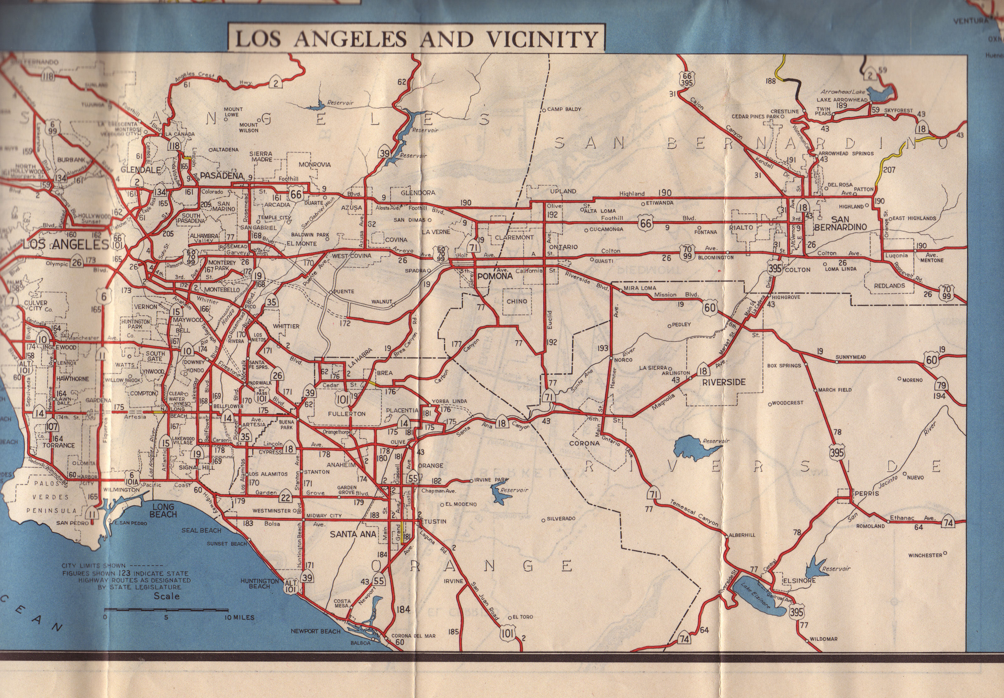
The following is a good map of the routings in Los Angeles at this time:
The following changes were made by the 1945 statutes (PDF, 146 MB):
| LRN | First Signage | Other Signage | Present Route (R) and Signage (S) | Action | Segment |
|---|---|---|---|---|---|
| LRN 2 | US 101 | US 101 | Change | Change northern end of
segment (a) to be the Golden Gate Approach: “(a) The junction
of [LRN 56] (Funston Approach) and the approach to the Golden Gate
Bridge in the Presidio of San Francisco to the
international...” (Chapter 1214) |
|
| LRN 62 | CA 39 | CA 39 | Extend | Reunify segments (a) and (b)
to create the original 1935 definition: [LRN 171] near Buena Park to
[LRN 9] near Azuza (Chapter 1269) |
 Phase II: Early Growth (1915-1932)
  Phase IV: Building the Freeway System (1947-1962))
© 1996-2020 Daniel P.
Faigin.
Maintained by: Daniel P. Faigin <webmaster@cahighways.org>.