California Highways:
Auto Trails were the earliest form of signed Automotive highways in the United States. The intent of the Auto Trails were typically to connect two or several major waypoints together in a well signed routing that could be followed by drivers. Auto Trails were typically managed and signed by private associations or promotion groups as opposed to government agencies. This led to some irregularities regarding where Auto Trail alignments went as certain interests would often influence where they were signed. Within California the signing of the Auto Trails was often contracted out to the Automobile Club of Southern California and California State Automobile Association. Auto Trail shields were mostly vertical rectangles but there was no true universal design for way markers. Some early Auto Trails such as the American El Camino Real used Mission Bells instead. Auto Trails in general did not have universal forms of signage. The Auto Trail era was before the advent of signage standards which led to the MUTCD. Most major Auto Trails were signed on highways which became part of the US System.
The California Highways: Route by Route podcast (a joint project of this website and Gribblenation) has a whole episode on Auto Trails.
The following pages provide information about some of the more prominent named trails and roads in California:
![[DeAnza]](images/deanza.jpg) The De Anza Trail is a National Historic Trail that runs from Arizona to the San Francisco Bay area.
This page provides information on the trail, its history, and routing. The El Camino Real (The Kings Road) was the original state highway. This page provides the legislative definition of the route and
the history of the route. The American iteration of El Camino Real began
to be signed in 1906 and is the oldest example of an Auto Trail in
California. The purpose of El Camino Real was to provide a signed
touring highway which connected the twenty one Spanish Mission sites in
California from San Diego north to Sonoma. Much of El Camino Real would
become heavily associated with LRN 2 and US 101. The Auto Trail was
signed along other state highway segments on the north and east side of
San Francisco Bay. Today El Camino Real is also signed on Route 87,
Route 82, I-280, Route 37, Route 121 and Route 12. El Camino Real has
always been signed with Mission Bells.
The De Anza Trail is a National Historic Trail that runs from Arizona to the San Francisco Bay area.
This page provides information on the trail, its history, and routing. The El Camino Real (The Kings Road) was the original state highway. This page provides the legislative definition of the route and
the history of the route. The American iteration of El Camino Real began
to be signed in 1906 and is the oldest example of an Auto Trail in
California. The purpose of El Camino Real was to provide a signed
touring highway which connected the twenty one Spanish Mission sites in
California from San Diego north to Sonoma. Much of El Camino Real would
become heavily associated with LRN 2 and US 101. The Auto Trail was
signed along other state highway segments on the north and east side of
San Francisco Bay. Today El Camino Real is also signed on Route 87,
Route 82, I-280, Route 37, Route 121 and Route 12. El Camino Real has
always been signed with Mission Bells.Other trails do not have separate pages, but are discussed on the pages
for the relevant routes. Here is some summary information for the auto
trails that were/are in California. S. Varner has a lot of information on trails, including lists of known trails. The Federal Highway Administration also has a nice white paper webpage on the subject.
(Source: California Highways and Gribblenation, California
Highways: Route by Route Episode 2.15, August 2024)

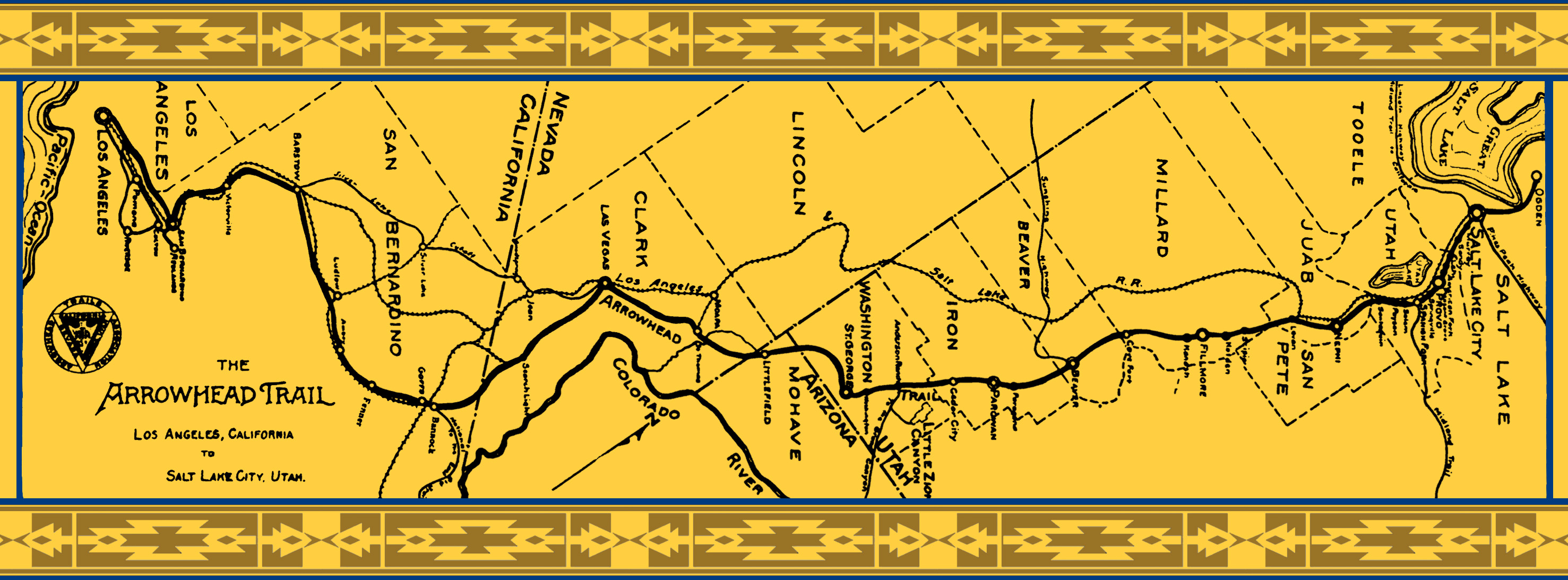
 Arrowhead Trail. The Arrowhead Trail was an Auto Trail that
was plotted out in 1915 when promoter and race car driver Charles H.
Bigelow drove the entire planned route from Salt Lake City to Los
Angeles. The Arrowhead Trail largely followed the path of the Los
Angeles-Salt Lake Road through the Mojave Desert. The original alignment
of the Arrowhead Trail entered California near Bannock siding along what
is now US 95. The early Arrowhead Trail largely was concurrent with the
National Old Trails Road from Bannock all the way to Los Angeles. In
1925, the Silver Lake Cutoff was constructed from Las Vegas to Barstow.
The Arrowhead Trail was then realigned onto the far shorter alignment
that gave it enhanced utility. The Silver Lake Cutoff would be adopted
as a portion of LRN 31 also during 1925; LRN 31 subsequently became US 91. The Arrowhead Trail in general is heavily tied to the history of US 91 and to a somewhat lesser extent I-15. The shield design was generally
black and white displaying a large arrowhead or downward pointing
triangle.
Arrowhead Trail. The Arrowhead Trail was an Auto Trail that
was plotted out in 1915 when promoter and race car driver Charles H.
Bigelow drove the entire planned route from Salt Lake City to Los
Angeles. The Arrowhead Trail largely followed the path of the Los
Angeles-Salt Lake Road through the Mojave Desert. The original alignment
of the Arrowhead Trail entered California near Bannock siding along what
is now US 95. The early Arrowhead Trail largely was concurrent with the
National Old Trails Road from Bannock all the way to Los Angeles. In
1925, the Silver Lake Cutoff was constructed from Las Vegas to Barstow.
The Arrowhead Trail was then realigned onto the far shorter alignment
that gave it enhanced utility. The Silver Lake Cutoff would be adopted
as a portion of LRN 31 also during 1925; LRN 31 subsequently became US 91. The Arrowhead Trail in general is heavily tied to the history of US 91 and to a somewhat lesser extent I-15. The shield design was generally
black and white displaying a large arrowhead or downward pointing
triangle.  Atlantic & Pacific Highway.
The Atlantic & Pacific Highway was plotted between New
York City and Los Angeles during the 1920s. The highway would largely
follow the future routing of US 60/US 70 along LRN 64 and LRN 26 from
Blythe to Los Angeles. The Atlantic & Pacific Highway had a yellow
and black shield with an “AP” symbol.
Atlantic & Pacific Highway.
The Atlantic & Pacific Highway was plotted between New
York City and Los Angeles during the 1920s. The highway would largely
follow the future routing of US 60/US 70 along LRN 64 and LRN 26 from
Blythe to Los Angeles. The Atlantic & Pacific Highway had a yellow
and black shield with an “AP” symbol.
 Bankhead Highway
/ Dixie Overland Highway. The Bankhead Highway
was plotted in 1916 between San Diego and Washington, D.C. The Dixie
Overland Highway was plotted in 1914 by the Automobile Club of
Savannah between San Diego and Savannah, GA. The routings of the
Bankhead Highway and Dixie Overland Highway in California were the same
as the Old Spanish Trail, running along LRN 12 from San Diego to El
Centro (subsequently US 80), and LRN 27 from El Centro to the Arizona
border (again, US 80). The Bankhead Highway shield was yellow and black
with a “BH” symbol. The Dixie Overland Highway was blue and
white (sometimes red and white) with a “DOH” symbol. Both
highways were connected with the "Southern Cause" narrative (see below).
Bankhead Highway
/ Dixie Overland Highway. The Bankhead Highway
was plotted in 1916 between San Diego and Washington, D.C. The Dixie
Overland Highway was plotted in 1914 by the Automobile Club of
Savannah between San Diego and Savannah, GA. The routings of the
Bankhead Highway and Dixie Overland Highway in California were the same
as the Old Spanish Trail, running along LRN 12 from San Diego to El
Centro (subsequently US 80), and LRN 27 from El Centro to the Arizona
border (again, US 80). The Bankhead Highway shield was yellow and black
with a “BH” symbol. The Dixie Overland Highway was blue and
white (sometimes red and white) with a “DOH” symbol. Both
highways were connected with the "Southern Cause" narrative (see below). California-Banff Beeline
Highway. The California-Banff Beeline Highway was
plotted between Banff, Alberta and Los Angeles. The entire highway was
co-signed with the Pacific Highway in California. The California-Banff
Beeline Highway shield was white and blue.
California-Banff Beeline
Highway. The California-Banff Beeline Highway was
plotted between Banff, Alberta and Los Angeles. The entire highway was
co-signed with the Pacific Highway in California. The California-Banff
Beeline Highway shield was white and blue.  El Camino Sierra.
El Camino Sierra has origins in the formation of the Inyo Good
Roads Club which was founded in April of 1910. El Camino Sierra was
formally dedicated in August of 1910 during a tour of the planned route
which was attended by then California Governor James Gillett. Much of
early El Camino Sierra was one-for-one with the 1909 First State Highway
Bond Act definition of LRN 23 between Saugus and Bridgeport. The
corridor generally is promoted as Santa Clarita-South Lake Tahoe in
modern times. El Camino Sierra is heavily associated with US 395 east of
the Sierra Nevada Range. The Auto Trail also has historic ties to US 6,
Route 14 and Route 89.
El Camino Sierra.
El Camino Sierra has origins in the formation of the Inyo Good
Roads Club which was founded in April of 1910. El Camino Sierra was
formally dedicated in August of 1910 during a tour of the planned route
which was attended by then California Governor James Gillett. Much of
early El Camino Sierra was one-for-one with the 1909 First State Highway
Bond Act definition of LRN 23 between Saugus and Bridgeport. The
corridor generally is promoted as Santa Clarita-South Lake Tahoe in
modern times. El Camino Sierra is heavily associated with US 395 east of
the Sierra Nevada Range. The Auto Trail also has historic ties to US 6,
Route 14 and Route 89.  Evergreen National Highway.
The Evergreen National Highway barely grazed California as it
largely followed the corridors now comprising US 95 and US 66 to
Arizona. The Evergreen National Highway was plotted primarily between El
Paso, Texas and Portland, Oregon, extended to Victoria, British
Columbia. Between Portland OR and Victoria, BC, the route was roughly US 99. Between Portland and Salt Lake City, the route followed U.S. 30/U.S.
30S (now I–84). From Salt Lake City, the route followed U.S. 91
(now I–15) to Las Vegas. From Las Vegas, NV to Needles CA, the
route followed Sign Route 195 (which later became US 95). The Evergreen
Highway then adopted the National Old Trails Road along US 66 (I-40)
between Kingman and Seligman, Arizona. The highway was marked with a
green and white shield. The center of the shield displayed a tree with
the name of the highway.
Evergreen National Highway.
The Evergreen National Highway barely grazed California as it
largely followed the corridors now comprising US 95 and US 66 to
Arizona. The Evergreen National Highway was plotted primarily between El
Paso, Texas and Portland, Oregon, extended to Victoria, British
Columbia. Between Portland OR and Victoria, BC, the route was roughly US 99. Between Portland and Salt Lake City, the route followed U.S. 30/U.S.
30S (now I–84). From Salt Lake City, the route followed U.S. 91
(now I–15) to Las Vegas. From Las Vegas, NV to Needles CA, the
route followed Sign Route 195 (which later became US 95). The Evergreen
Highway then adopted the National Old Trails Road along US 66 (I-40)
between Kingman and Seligman, Arizona. The highway was marked with a
green and white shield. The center of the shield displayed a tree with
the name of the highway.  Inland Route. The
Inland Route is another example of an Auto Trail largely
promoted by California on a state owned segment of State Highway. The
Inland Route was entirely concurrent with LRN 4 between Sacramento and
Los Angeles. The Inland Route was the most prominently signed highway
along the Old Ridge Route prior to US 99. The Inland Route was signed
with grey Auto Club style diamonds with red lettering. “Inland
Route” was displayed in the upper strip of the diamond.
Inland Route. The
Inland Route is another example of an Auto Trail largely
promoted by California on a state owned segment of State Highway. The
Inland Route was entirely concurrent with LRN 4 between Sacramento and
Los Angeles. The Inland Route was the most prominently signed highway
along the Old Ridge Route prior to US 99. The Inland Route was signed
with grey Auto Club style diamonds with red lettering. “Inland
Route” was displayed in the upper strip of the diamond.  Lee Highway. The Lee
Highway was plotted between New York and San Francisco in 1919. The
highway entered California near Yuma and was concurrent with the Old
Spanish Trail to San Diego. From San Diego the highway was concurrent
with the Pacific Highway to San Francisco. This was part of a larger
highway that ran from New York to Florida, then from Florida to San
Diego, then from San Diego to San Francisco. It was also part of the
"Southern Cause" narrative. The Lee Highway shield was blue and grey
displaying the word “Lee.”
Lee Highway. The Lee
Highway was plotted between New York and San Francisco in 1919. The
highway entered California near Yuma and was concurrent with the Old
Spanish Trail to San Diego. From San Diego the highway was concurrent
with the Pacific Highway to San Francisco. This was part of a larger
highway that ran from New York to Florida, then from Florida to San
Diego, then from San Diego to San Francisco. It was also part of the
"Southern Cause" narrative. The Lee Highway shield was blue and grey
displaying the word “Lee.”
 Lincoln Highway. During 1912, Indiana Businessman Carl G. Fisher
conceptualized the Lincoln Highway as a major
transcontinental Auto Trail. The Lincoln Highway was formally dedicated
on October 31, 1913, and was aligned west of Fallon via split branches
over the Sierra Nevada Mountains. The routing can be confusing because
things kept changing over time. The Northern Branch of the
Lincoln Highway entered California via the Dog Valley Grade near Verdi,
NV and followed it (using Dog Valley Road and Prosser Dam Road) to
Truckee. The second generation of this moved to LRN 38 between Truckee
and the Nevada State Line. From Truckee the northern branch climbed over
Donner Pass following much of the grade of the Dutch Flat & Donner
Lake Wagon Road (LRN 37, US 40) towards Auburn. The original variation
used Old Donner Summit Road. Later variations used Donner Pass Road
until US 40 was completed. Near Colfax, the original route used Norton
Grade Road; with the second generation routing using Rollins Lake Road.
From Auburn the Northern branch followed LRN 17 (US 40) and LRN 3 (US 40/US 99E, Route 160) to downtown Sacramento where it consolidated with
the Southern Branch. This segment is roughly I-80 and Business Route 80 today. The Southern
Branch of the Lincoln Highway was sometimes known as the Pioneer
Branch. The southern branch split from the mainline in Reno, NV
and followed the Lake Tahoe Wagon Road (LRN 11, US 50) over
Johnson’s Pass west over the Sierra Nevada to Sacramento.
But there were variations along this route. For example, the 3rd
generation of the Southern Branch followed US 50 much closer in Nevada.
Near Folsom, there were routings that used White Rock Road, Placerville
Road, and Bidwell Street. The original route used Folsom Blvd out of
Folsom; a later variation used Greenback Lane from Folsom to Citrus
Heights. From Sacramento, there were also multiple routes. The 1913
Lincoln Highway branched south via Stockton Blvd, early LRN 4 (now County Sign Route J10) and then later LRN 4 (US 99, US 50, today's Route 99) towards
Stockton. From Stockton the highway followed Lower Sacramento Road, and
later LRN 4, to LRN 5. It then followed LRN 5 (US 50, today's I-205)
over Altamont Pass to Oakland (via US 50, today's I-580) where it
crossed San Francisco Bay to San Francisco. A later iteration of the
route roughly followed Route 16 and Route 275 (LRN 6), US 40 (LRN 6, LRN 7), Route 12 (LRN 8), Route 29 (LRN 74), and US 40 (LRN 7 and LRN 14)
ove rthe Carquinez Bridge, and then to Berkeley, where it used the ferry
to cross over to Fisherman's Wharf (before the Oakland Bay Bridge was
built). Within San Francisco the early Lincoln Highway landed at the
Embarcadero Ferry Terminal. The highway followed Embarcadero, Market
Street, Van Ness Avenue, Chestnut Street, Lyon Street, Lombard Street,
Presidio Boulevard, Barnard Avenue, Arguello Boulevard, Lake Street, 28th
Avenue, Lake Street and El Camino Del Mar to the Legion of Honor Water
Fountain. A second variation crossed on Geary Blvd, 36th,
Clement, and Legion of Honor Drive. The third generation used Hyde,
North Point, and Van Ness (US 101) to California Street, across
California to 32nd, and then up to El Camino Del Mar, ending
again at the Legion of Honor Water Fountain. But these are just some
routings. The Lincoln Highway Association, unlike other many other major
Auto Trail Associations, never disbanded. The organization still
field-signs the Lincoln Highway in modern times. The Lincoln Highway
Association maintains an interactive map that shows all the routes that the highway took, which you can expand to show you the specific modern streets. The
Lincoln Highway shield is red, white and blue with a “L”
symbol.
Lincoln Highway. During 1912, Indiana Businessman Carl G. Fisher
conceptualized the Lincoln Highway as a major
transcontinental Auto Trail. The Lincoln Highway was formally dedicated
on October 31, 1913, and was aligned west of Fallon via split branches
over the Sierra Nevada Mountains. The routing can be confusing because
things kept changing over time. The Northern Branch of the
Lincoln Highway entered California via the Dog Valley Grade near Verdi,
NV and followed it (using Dog Valley Road and Prosser Dam Road) to
Truckee. The second generation of this moved to LRN 38 between Truckee
and the Nevada State Line. From Truckee the northern branch climbed over
Donner Pass following much of the grade of the Dutch Flat & Donner
Lake Wagon Road (LRN 37, US 40) towards Auburn. The original variation
used Old Donner Summit Road. Later variations used Donner Pass Road
until US 40 was completed. Near Colfax, the original route used Norton
Grade Road; with the second generation routing using Rollins Lake Road.
From Auburn the Northern branch followed LRN 17 (US 40) and LRN 3 (US 40/US 99E, Route 160) to downtown Sacramento where it consolidated with
the Southern Branch. This segment is roughly I-80 and Business Route 80 today. The Southern
Branch of the Lincoln Highway was sometimes known as the Pioneer
Branch. The southern branch split from the mainline in Reno, NV
and followed the Lake Tahoe Wagon Road (LRN 11, US 50) over
Johnson’s Pass west over the Sierra Nevada to Sacramento.
But there were variations along this route. For example, the 3rd
generation of the Southern Branch followed US 50 much closer in Nevada.
Near Folsom, there were routings that used White Rock Road, Placerville
Road, and Bidwell Street. The original route used Folsom Blvd out of
Folsom; a later variation used Greenback Lane from Folsom to Citrus
Heights. From Sacramento, there were also multiple routes. The 1913
Lincoln Highway branched south via Stockton Blvd, early LRN 4 (now County Sign Route J10) and then later LRN 4 (US 99, US 50, today's Route 99) towards
Stockton. From Stockton the highway followed Lower Sacramento Road, and
later LRN 4, to LRN 5. It then followed LRN 5 (US 50, today's I-205)
over Altamont Pass to Oakland (via US 50, today's I-580) where it
crossed San Francisco Bay to San Francisco. A later iteration of the
route roughly followed Route 16 and Route 275 (LRN 6), US 40 (LRN 6, LRN 7), Route 12 (LRN 8), Route 29 (LRN 74), and US 40 (LRN 7 and LRN 14)
ove rthe Carquinez Bridge, and then to Berkeley, where it used the ferry
to cross over to Fisherman's Wharf (before the Oakland Bay Bridge was
built). Within San Francisco the early Lincoln Highway landed at the
Embarcadero Ferry Terminal. The highway followed Embarcadero, Market
Street, Van Ness Avenue, Chestnut Street, Lyon Street, Lombard Street,
Presidio Boulevard, Barnard Avenue, Arguello Boulevard, Lake Street, 28th
Avenue, Lake Street and El Camino Del Mar to the Legion of Honor Water
Fountain. A second variation crossed on Geary Blvd, 36th,
Clement, and Legion of Honor Drive. The third generation used Hyde,
North Point, and Van Ness (US 101) to California Street, across
California to 32nd, and then up to El Camino Del Mar, ending
again at the Legion of Honor Water Fountain. But these are just some
routings. The Lincoln Highway Association, unlike other many other major
Auto Trail Associations, never disbanded. The organization still
field-signs the Lincoln Highway in modern times. The Lincoln Highway
Association maintains an interactive map that shows all the routes that the highway took, which you can expand to show you the specific modern streets. The
Lincoln Highway shield is red, white and blue with a “L”
symbol. Lone Star Trail. The
Lone Star Trail was plotted from St. Augustine, Florida to
Santa Ana, California. The routing within California is not known beyond
it entering the state near Yuma. Note that this is not
the Lone Star Route, which ran from Chicago, IL to Galveston
and Brownsville, TX.
Lone Star Trail. The
Lone Star Trail was plotted from St. Augustine, Florida to
Santa Ana, California. The routing within California is not known beyond
it entering the state near Yuma. Note that this is not
the Lone Star Route, which ran from Chicago, IL to Galveston
and Brownsville, TX.
 National Old Trails Road. In April of 1912, the National Old Trails
Road (NOTR) was organized with the goal of signing a
trans-continental highway between Baltimore and Los Angeles. Building a
modern road for automotive use through the Mojave Desert of California
would prove to be particularly difficult as State Highway Maintenance
didn't exist and the general path of travel was alongside the service
routes of railroads. The first Auto Trail through Cajon Pass was the
Santa Fe-Grand Canyon Needles National Highway which was first signed in
Cajon Pass by 1913. NOTR organizers later adopted the routing of the
Santa Fe-Grand Canyon Needles National Highway in the western United
States by 1914. The NOTR predated state maintenance in the Mojave Desert
east of Barstow. This segment of highway would eventually become part of
LRN 58 by way of the 1919 Third State Highway Bond Act. The NOTR was
able secure funding to pave the route through Cajon Pass and construct
the 1914 Crowder Canyon Bridge; this later became part of LRN 31. From
San Bernardino, the NOTR used what became LRN 9 to travel westward
towards Pasadena. From Pasadena into Los Angeles the route followed
various city streets; it didn't follow a legislative route as the state
did not maintain routes within cities in the NOTR-era. Much of the NOTR
formed the basis for what would become US 66. The terminus of the NOTR
was at the ACSC headquarters at 7th Street and Broadway in
Los Angeles. The NOTR terminus is often mistakenly co-opted into the
lore of US 66 given the close association in the history of the two
highways. The NOTR had two shields: a diamond design displayed symbol
showing the entire highway, and a red, white and blue variation that
showed destinations.
National Old Trails Road. In April of 1912, the National Old Trails
Road (NOTR) was organized with the goal of signing a
trans-continental highway between Baltimore and Los Angeles. Building a
modern road for automotive use through the Mojave Desert of California
would prove to be particularly difficult as State Highway Maintenance
didn't exist and the general path of travel was alongside the service
routes of railroads. The first Auto Trail through Cajon Pass was the
Santa Fe-Grand Canyon Needles National Highway which was first signed in
Cajon Pass by 1913. NOTR organizers later adopted the routing of the
Santa Fe-Grand Canyon Needles National Highway in the western United
States by 1914. The NOTR predated state maintenance in the Mojave Desert
east of Barstow. This segment of highway would eventually become part of
LRN 58 by way of the 1919 Third State Highway Bond Act. The NOTR was
able secure funding to pave the route through Cajon Pass and construct
the 1914 Crowder Canyon Bridge; this later became part of LRN 31. From
San Bernardino, the NOTR used what became LRN 9 to travel westward
towards Pasadena. From Pasadena into Los Angeles the route followed
various city streets; it didn't follow a legislative route as the state
did not maintain routes within cities in the NOTR-era. Much of the NOTR
formed the basis for what would become US 66. The terminus of the NOTR
was at the ACSC headquarters at 7th Street and Broadway in
Los Angeles. The NOTR terminus is often mistakenly co-opted into the
lore of US 66 given the close association in the history of the two
highways. The NOTR had two shields: a diamond design displayed symbol
showing the entire highway, and a red, white and blue variation that
showed destinations. 
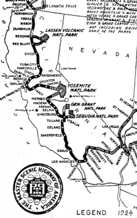 National Park-to-Park Highway. The National
Park to Park Highway (NPP) was plotted in 1916. The purpose of
the NPP was to plot a singular Auto Trail between the then existing
National Parks. Within California, the NPP was concurrent with the
National Old Trails Road near Needles to Los Angeles. From Los Angeles
the NPP multiplexed the Inland Route along LRN 4 to Merced. The highway
had a branches in Visalia that went to Sequoia National Park (future
Route 198) and General Grant National Park (future Sign Route 65, Route 69, Route 245 and Route 180). From Merced the NPP followed LRN 18 (Route 140) to Yosemite National Park. The highway departed Yosemite via the
Old Big Oak Flat Road, LRN 40 and LRN 66 (both Route 120) to Oakdale.
From Oakdale the NPP followed a series of local roads (likely Mariposa
Road) to Stockton. The NPP followed LRN 5 from Stockton west to Oakland
and then LRN 14 to the Benicia-Martinez Ferry. The NPP followed LRN 7
and LRN 6 towards Sacramento (US 40, Route 275, Route 16 along N Street)
via the Yolo Causeway. From Sacramento the highway continued north via
LRN 3 (Route 160, US 40, US 99E) to Red Bluff. At Red Bluff the NPP had
two eastern spurs via LRN 29 (Route 36) and LRN 20 (Route 44) to Lassen
Volcanic National Park. From Red Bluff the mainline NPP followed LRN 3
to the Oregon state line. The highway was signed with a black and white
shield displaying full name and two large capital
“P”s—one forward facing, one reverse facing.
National Park-to-Park Highway. The National
Park to Park Highway (NPP) was plotted in 1916. The purpose of
the NPP was to plot a singular Auto Trail between the then existing
National Parks. Within California, the NPP was concurrent with the
National Old Trails Road near Needles to Los Angeles. From Los Angeles
the NPP multiplexed the Inland Route along LRN 4 to Merced. The highway
had a branches in Visalia that went to Sequoia National Park (future
Route 198) and General Grant National Park (future Sign Route 65, Route 69, Route 245 and Route 180). From Merced the NPP followed LRN 18 (Route 140) to Yosemite National Park. The highway departed Yosemite via the
Old Big Oak Flat Road, LRN 40 and LRN 66 (both Route 120) to Oakdale.
From Oakdale the NPP followed a series of local roads (likely Mariposa
Road) to Stockton. The NPP followed LRN 5 from Stockton west to Oakland
and then LRN 14 to the Benicia-Martinez Ferry. The NPP followed LRN 7
and LRN 6 towards Sacramento (US 40, Route 275, Route 16 along N Street)
via the Yolo Causeway. From Sacramento the highway continued north via
LRN 3 (Route 160, US 40, US 99E) to Red Bluff. At Red Bluff the NPP had
two eastern spurs via LRN 29 (Route 36) and LRN 20 (Route 44) to Lassen
Volcanic National Park. From Red Bluff the mainline NPP followed LRN 3
to the Oregon state line. The highway was signed with a black and white
shield displaying full name and two large capital
“P”s—one forward facing, one reverse facing. New Santa Fe Trail.
The New Santa Fe Trail was plotted from Kansas City, Missouri
to Los Angeles. Within California this highway was completely concurrent
with the National Old Trails Road. The highway was marked with a black
and white colored reassurance shield. The shield displayed a symbol
identical to the Atchison, Topeka & Santa Fe Railway logo.
New Santa Fe Trail.
The New Santa Fe Trail was plotted from Kansas City, Missouri
to Los Angeles. Within California this highway was completely concurrent
with the National Old Trails Road. The highway was marked with a black
and white colored reassurance shield. The shield displayed a symbol
identical to the Atchison, Topeka & Santa Fe Railway logo.  The New Santa Fe Trail should be distinguished
from Santa Fe National Historic Trail, which was not in California. The Old Santa Fe Trail was the main overland transport route for goods and people to the west. It ran from Kansas City, MO to Santa Fe, NM.
The New Santa Fe Trail should be distinguished
from Santa Fe National Historic Trail, which was not in California. The Old Santa Fe Trail was the main overland transport route for goods and people to the west. It ran from Kansas City, MO to Santa Fe, NM.

 Old Spanish Trail (Auto Trail). Plotted in 1915, the Old
Spanish Trail (OST) Auto Trail spanned from downtown San Diego
east to St. Augustine, Florida. The OST generally followed an alignment
that emulated the trade corridors explored by the Spanish in what is now
the southern United States. The western terminus of the OST was at
Horton Plaza in San Diego at 4th Street and Broadway. Horton
Plaza was once adorned by the Pacific Zero Mile that was twinned via an
Atlantic structure in St. Augustine. The OST originally followed what is
now Route 94 east of San Diego to Imperial Valley. The highway crossed
the Algodones Dunes Plank Road and entered Arizona at the Colorado River
near Yuma. By 1931, the latter day OST was essentially concurrent with
US 80 along LRN 12 and LRN 27. The Old Spanish Trail shield was red,
white and yellow with an “OST” symbol. It is
important to distinguish the Old Spanish Trail—Auto Trail
from the Old Spanish Trail National Historic Trail. The latter
is the historical trade route, which tended to approximate the National
Old Trails Road.
Old Spanish Trail (Auto Trail). Plotted in 1915, the Old
Spanish Trail (OST) Auto Trail spanned from downtown San Diego
east to St. Augustine, Florida. The OST generally followed an alignment
that emulated the trade corridors explored by the Spanish in what is now
the southern United States. The western terminus of the OST was at
Horton Plaza in San Diego at 4th Street and Broadway. Horton
Plaza was once adorned by the Pacific Zero Mile that was twinned via an
Atlantic structure in St. Augustine. The OST originally followed what is
now Route 94 east of San Diego to Imperial Valley. The highway crossed
the Algodones Dunes Plank Road and entered Arizona at the Colorado River
near Yuma. By 1931, the latter day OST was essentially concurrent with
US 80 along LRN 12 and LRN 27. The Old Spanish Trail shield was red,
white and yellow with an “OST” symbol. It is
important to distinguish the Old Spanish Trail—Auto Trail
from the Old Spanish Trail National Historic Trail. The latter
is the historical trade route, which tended to approximate the National
Old Trails Road.  Pacific Highway. The
Pacific Highway was plotted between San Diego and Vancouver, BC
in 1913. Unlike most Auto Trails the Pacific Highway had a small segment
located in another country (Canada). The Pacific Highway followed LRN 3
from the Oregon state line to Woodland. Much of the Pacific Highway
north of Woodland in general is tied to the history of US 99. It then
followed LRN 7 (US 99W / Route 113 and US 40) to LRN 14 (US 40). The
Pacific Highway then followed LRN 14 (US 40), LRN 5 (US 50 and Sign
Route 9, as well as portions of pre-1964 Sign Route 17, and post-1964
Route 238) to San Jose, and then LRN 2 (US 101) to San Diego. The
Pacific Highway shields were a white and black diamond design displaying
the full name.
Pacific Highway. The
Pacific Highway was plotted between San Diego and Vancouver, BC
in 1913. Unlike most Auto Trails the Pacific Highway had a small segment
located in another country (Canada). The Pacific Highway followed LRN 3
from the Oregon state line to Woodland. Much of the Pacific Highway
north of Woodland in general is tied to the history of US 99. It then
followed LRN 7 (US 99W / Route 113 and US 40) to LRN 14 (US 40). The
Pacific Highway then followed LRN 14 (US 40), LRN 5 (US 50 and Sign
Route 9, as well as portions of pre-1964 Sign Route 17, and post-1964
Route 238) to San Jose, and then LRN 2 (US 101) to San Diego. The
Pacific Highway shields were a white and black diamond design displaying
the full name.  Pikes Peak Ocean-to-Ocean
Highway. The Pikes Peak Ocean-to-Ocean Highway was
plotted between New York City and Los Angeles in 1914. The highway was
fully concurrent with the National Old Trails Road in California. The
Pikes Peak Ocean-to-Ocean Highway was signed with a red and white
shield.
Pikes Peak Ocean-to-Ocean
Highway. The Pikes Peak Ocean-to-Ocean Highway was
plotted between New York City and Los Angeles in 1914. The highway was
fully concurrent with the National Old Trails Road in California. The
Pikes Peak Ocean-to-Ocean Highway was signed with a red and white
shield.  Redwood Highway. The
Redwood Highway was heavily promoted as an Auto Trail mostly by
California from the northern end of San Francisco Bay to Grants Pass,
OR. The Redwood Highway corridor in California was adopted as LRN 1
between San Francisco Bay and Crescent City as part of the 1909 First
State Highway Bond Act. LRN 1 was extended to the Oregon state line by
way of the 1919 Third State Highway Bond Act. Oregon added their segment
of the Redwood Highway to state inventory during 1917. Modern US 101
from the Golden Gate Bridge to Crescent City along with the entirety of
US 199 are still known as the Redwood Highway. The Redwood Highway was
signed with a standard yellow CSAA shield.
Redwood Highway. The
Redwood Highway was heavily promoted as an Auto Trail mostly by
California from the northern end of San Francisco Bay to Grants Pass,
OR. The Redwood Highway corridor in California was adopted as LRN 1
between San Francisco Bay and Crescent City as part of the 1909 First
State Highway Bond Act. LRN 1 was extended to the Oregon state line by
way of the 1919 Third State Highway Bond Act. Oregon added their segment
of the Redwood Highway to state inventory during 1917. Modern US 101
from the Golden Gate Bridge to Crescent City along with the entirety of
US 199 are still known as the Redwood Highway. The Redwood Highway was
signed with a standard yellow CSAA shield.  Roosevelt Midland Trail.
The Roosevelt Midland Trail began being signed in 1913
between California and Washington D.C. The Midland Trail had dual
terminus points in Los Angeles and San Francisco. The Midland Trail
entered California via Westgard Pass (Route 168) where it branched
numerous ways upon reaching Owens Valley. The originally intention was
for the Midland Trail to followed the proposed Piute Pass Highway over
the Sierra Nevada range to Tollhouse Road (Route 168) in Fresno County.
One branch of the Midland Trail utilized the Tioga Road (LRN 40) and
Altamont Pass (LRN 5) to reach San Francisco. The more northerly San
Francisco routing passed through South Lake Tahoe, Placerville and
Sacramento (LRN 11). The southern San Francisco Route went south to the
Tehachapi Pass Road (future LRN 58 and US 466) to reach the Central
Valley. The southern route followed LRN 4 to the Modesto area and cut
west towards Altamont Pass. The Los Angeles route followed much of LRN 23 south from Owens Valley. The highway was signed with orange and black
shields.
Roosevelt Midland Trail.
The Roosevelt Midland Trail began being signed in 1913
between California and Washington D.C. The Midland Trail had dual
terminus points in Los Angeles and San Francisco. The Midland Trail
entered California via Westgard Pass (Route 168) where it branched
numerous ways upon reaching Owens Valley. The originally intention was
for the Midland Trail to followed the proposed Piute Pass Highway over
the Sierra Nevada range to Tollhouse Road (Route 168) in Fresno County.
One branch of the Midland Trail utilized the Tioga Road (LRN 40) and
Altamont Pass (LRN 5) to reach San Francisco. The more northerly San
Francisco routing passed through South Lake Tahoe, Placerville and
Sacramento (LRN 11). The southern San Francisco Route went south to the
Tehachapi Pass Road (future LRN 58 and US 466) to reach the Central
Valley. The southern route followed LRN 4 to the Modesto area and cut
west towards Altamont Pass. The Los Angeles route followed much of LRN 23 south from Owens Valley. The highway was signed with orange and black
shields.  Southern National Highway.
The full alignment of the Southern National Highway outside
of California is unclear. The Southern National Highway entered
California near Blythe and followed LRN 64 (future US 60 and US 70) to
Coachella Valley. From Coachella Valley the highway turned south via LRN 26 (future US 99) towards El Centro. From El Centro the highway followed
the Old Spanish Trail west to San Diego. A plank road made of pieces of
wood that were tied together was the first road across the Imperial
Valley to Yuma; this was later replaced by US 80 across California and
part of Arizona. Pieces remain just off of I-8. The plank road was part
of the Southern National Highway, which created the first
all-season southern route across the U.S, between Washington, D.C., and
San Diego. The named highway had its origins in the early 1910s, and
came into prominence in 1915, predating the Old Spanish Trail by more
than eight years. To arouse interest in the Pan-Pacific Exposition of
1915, a cross-country caravan set out from San Diego along the Southern
National Highway in November 2, 1915, and reached D.C. in 32 days. The
Southern National Highway was signed with a red, white and blue shield.
The shield displayed a star with the initials “SNH.”
Southern National Highway.
The full alignment of the Southern National Highway outside
of California is unclear. The Southern National Highway entered
California near Blythe and followed LRN 64 (future US 60 and US 70) to
Coachella Valley. From Coachella Valley the highway turned south via LRN 26 (future US 99) towards El Centro. From El Centro the highway followed
the Old Spanish Trail west to San Diego. A plank road made of pieces of
wood that were tied together was the first road across the Imperial
Valley to Yuma; this was later replaced by US 80 across California and
part of Arizona. Pieces remain just off of I-8. The plank road was part
of the Southern National Highway, which created the first
all-season southern route across the U.S, between Washington, D.C., and
San Diego. The named highway had its origins in the early 1910s, and
came into prominence in 1915, predating the Old Spanish Trail by more
than eight years. To arouse interest in the Pan-Pacific Exposition of
1915, a cross-country caravan set out from San Diego along the Southern
National Highway in November 2, 1915, and reached D.C. in 32 days. The
Southern National Highway was signed with a red, white and blue shield.
The shield displayed a star with the initials “SNH.” Victory Highway. The
Victory Highway Association was founded in 1921 with the
purpose of plotting a highway between San Francisco and New York. The
Victory Highway from the Nevada state line west to Sacramento was
concurrent with the northern route of the Lincoln Highway. The Victory
Highway diverged significantly in the Sacramento River Delta following
much of what is now Route 160. The Victory Highway would realign into a
corridor roughly following US 40. The association would rebrand as the
US 40 Association in 1938. The Victory Highway had metallic looking
“V” shaped shield.
Victory Highway. The
Victory Highway Association was founded in 1921 with the
purpose of plotting a highway between San Francisco and New York. The
Victory Highway from the Nevada state line west to Sacramento was
concurrent with the northern route of the Lincoln Highway. The Victory
Highway diverged significantly in the Sacramento River Delta following
much of what is now Route 160. The Victory Highway would realign into a
corridor roughly following US 40. The association would rebrand as the
US 40 Association in 1938. The Victory Highway had metallic looking
“V” shaped shield. The National Park Service also signs a number of routes:
 Juan Bautista de Anza National
Historic Trail. The Juan Bautista de Anza National Historic Trail spans from the Mexican border in Nogales, Arizona to San Francisco. The highway
emulates the approximately 1,200 mile path of trail by the Juan Bautista
de Anza expedition of 1774. The trail is marked with NPS sourced
signage.
Juan Bautista de Anza National
Historic Trail. The Juan Bautista de Anza National Historic Trail spans from the Mexican border in Nogales, Arizona to San Francisco. The highway
emulates the approximately 1,200 mile path of trail by the Juan Bautista
de Anza expedition of 1774. The trail is marked with NPS sourced
signage.  Pony Express National Historic
Trail. The Pony Express National Historic Trail spans from Saint Joseph, Missouri to San Francisco. The routing in places is signed but NPS maps
generally show the original overland corridor and locations of relay
houses. Within California the mainline of the Pony Express followed the
Lake Tahoe Wagon Road over the Sierra Nevada range which would later
become part of the south Lincoln Highway and early US 50. West of
Sacramento, signage can sometimes be found near I-80, I-680 and Route 24. The Partnership for National Historic Trails also has a page on the route.Old Spanish National Historic Trail
(Trade Route). The Old Spanish National Historic Trail, as distinguished from the Auto Trail discussed above, was a major trade route running between
Santa Fe NM and California. It was from a combination of the indigenous
footpaths, early trade and exploration routes, and horse and mule routes
that the trail network known collectively as the “Old Spanish
Trail” evolved. In California, the route was roughly similar to
the Arrowhead Trail. There is also a Old Spanish Trail Association.
Pony Express National Historic
Trail. The Pony Express National Historic Trail spans from Saint Joseph, Missouri to San Francisco. The routing in places is signed but NPS maps
generally show the original overland corridor and locations of relay
houses. Within California the mainline of the Pony Express followed the
Lake Tahoe Wagon Road over the Sierra Nevada range which would later
become part of the south Lincoln Highway and early US 50. West of
Sacramento, signage can sometimes be found near I-80, I-680 and Route 24. The Partnership for National Historic Trails also has a page on the route.Old Spanish National Historic Trail
(Trade Route). The Old Spanish National Historic Trail, as distinguished from the Auto Trail discussed above, was a major trade route running between
Santa Fe NM and California. It was from a combination of the indigenous
footpaths, early trade and exploration routes, and horse and mule routes
that the trail network known collectively as the “Old Spanish
Trail” evolved. In California, the route was roughly similar to
the Arrowhead Trail. There is also a Old Spanish Trail Association.  Volcanic Legacy Scenic Byway
All American Road. The Volcanic Legacy Scenic Byway is a 500 mile journey from volcano to volcano. The southern end of the byway begins at California's Lake
Almanor, just miles from the active geothermal features at Lassen
Volcanic National Park. The northern end of the byway is capped by
Crater Lake National Park in Oregon where mysteries of the earth's
interior are studied. The Federal Highway Administration also has a page on this road; the route also has its own promotional webpage.
Volcanic Legacy Scenic Byway
All American Road. The Volcanic Legacy Scenic Byway is a 500 mile journey from volcano to volcano. The southern end of the byway begins at California's Lake
Almanor, just miles from the active geothermal features at Lassen
Volcanic National Park. The northern end of the byway is capped by
Crater Lake National Park in Oregon where mysteries of the earth's
interior are studied. The Federal Highway Administration also has a page on this road; the route also has its own promotional webpage.The following sites also provide good information on trails related to California:
 S. Varner's American Roads site has a page devoted to Auto Trails. Most important, it includes a list of North American Auto Trails.This site is devoted to the old roads--the marked trails that existed in the 1910s-1920s, before road
numbering came into wide usage.Lincoln Highway: The Lincoln Highway was the first transcontinental road for automobiles in the United States, dedicated in
1913. It winds its way over 3,000 miles between New York City and San
Francisco. In California, it ran along US 50 and portions of US 40.
S. Varner's American Roads site has a page devoted to Auto Trails. Most important, it includes a list of North American Auto Trails.This site is devoted to the old roads--the marked trails that existed in the 1910s-1920s, before road
numbering came into wide usage.Lincoln Highway: The Lincoln Highway was the first transcontinental road for automobiles in the United States, dedicated in
1913. It winds its way over 3,000 miles between New York City and San
Francisco. In California, it ran along US 50 and portions of US 40.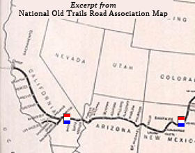 National Old Trails Road: The National Old Trails Road had been officially proposed in 1912 as a transcontinental highway stretching
from the southwestern U.S. to the Eastern Seaboard along such old routes
as the Santa Fe Trail and the National Road. The Automobile Club of
Southern California embraced the National Old Trails Road for the
long-distance motor vehicle travel options it would make possible. The
club, in collaboration with the National Old Trails Road Association,
saw the posting of signs along at least part of that route as a key
means of enabling motorists to better find their way to expositions
taking place in California (San Francisco, San Diego) in the 1915
timeframe. The first sign was placed at the Auto Club headquarters in
Los Angeles in August 1914. The sign-posting crew, directed by the
club’s road department, then made its way steadily eastward along
the route. The final sign in that effort was placed more than a year
later on September 3, 1915, in Kansas City, Missouri. More Information:
National Old Trails Road Page.Pikes Peak Ocean to Ocean Highway. This is one of the early transcontinental highways of the named trail era (about 1910-1926). The
course of the highway was from New York through Philadelphia,
Washington, Baltimore, Cumberland, Wheeling, Columbus, Dayton,
Indianapolis, Springfield, Ill., Hannibal, Mo., St. Joseph, Belleville,
Kans., Colorado Springs, Glenwood Springs, Salt Lake City, Reno,
Sacramento and Oakland to San Francisco (and in a later version, to Los
Angeles). Principle highways in California were US 40, US 50, US 99, and
Route 89. Maps can be found here.
National Old Trails Road: The National Old Trails Road had been officially proposed in 1912 as a transcontinental highway stretching
from the southwestern U.S. to the Eastern Seaboard along such old routes
as the Santa Fe Trail and the National Road. The Automobile Club of
Southern California embraced the National Old Trails Road for the
long-distance motor vehicle travel options it would make possible. The
club, in collaboration with the National Old Trails Road Association,
saw the posting of signs along at least part of that route as a key
means of enabling motorists to better find their way to expositions
taking place in California (San Francisco, San Diego) in the 1915
timeframe. The first sign was placed at the Auto Club headquarters in
Los Angeles in August 1914. The sign-posting crew, directed by the
club’s road department, then made its way steadily eastward along
the route. The final sign in that effort was placed more than a year
later on September 3, 1915, in Kansas City, Missouri. More Information:
National Old Trails Road Page.Pikes Peak Ocean to Ocean Highway. This is one of the early transcontinental highways of the named trail era (about 1910-1926). The
course of the highway was from New York through Philadelphia,
Washington, Baltimore, Cumberland, Wheeling, Columbus, Dayton,
Indianapolis, Springfield, Ill., Hannibal, Mo., St. Joseph, Belleville,
Kans., Colorado Springs, Glenwood Springs, Salt Lake City, Reno,
Sacramento and Oakland to San Francisco (and in a later version, to Los
Angeles). Principle highways in California were US 40, US 50, US 99, and
Route 89. Maps can be found here.The proposed Davis Highway was created in response to the Lincoln Highway by the United Daughters of the Confederacy (UDC). After the Lincoln Highway was announced in 1912, the UDC decided to create a Jefferson Davis Highway across Southern states to commemorate the "lost cause" (which often was a euphemism for a much more insidious cause). They cobbled together local roads and placed some monuments. On the monuments, however, they made the claim that Davis was the father of Transcontinental Highways because as secretary of War in 1853, Davis “surveyed for military use three routes across the United States. They claim these were for highways, bue the reality is that the surveys were for possible transcontinental railway paths — a Northern, a Central and two Southern Pacific surveys — plus a fifth survey up the West Coast. This latter survey was the justification for extending the route N from San Diego up US 99 to the Canadian border. But as usual, this was an after the fact, retro-justification for what they did.
Reflecting the trends of the 1910s and
1920s, there were other highways named to commemorate the "Southern
Cause". These include the Robert E. Lee Highway, the Dixie Overland Highway, and the Bankhead Highway (for John Hollis Bankhead, an Alabama politician and Confederate war hero). The move to
highway numbers in the late 1920s allowed these names to fade into
obscurity.
 Return to California Highways Home Page
  De Anza Trail
© 1996-2024 Daniel P.
Faigin.
Maintained by: Daniel P. Faigin <webmaster@cahighways.org>.