
 California Highways:
Click here for a key to the symbols used. An explanation of acronyms may be found at the bottom of the page.
 Routing
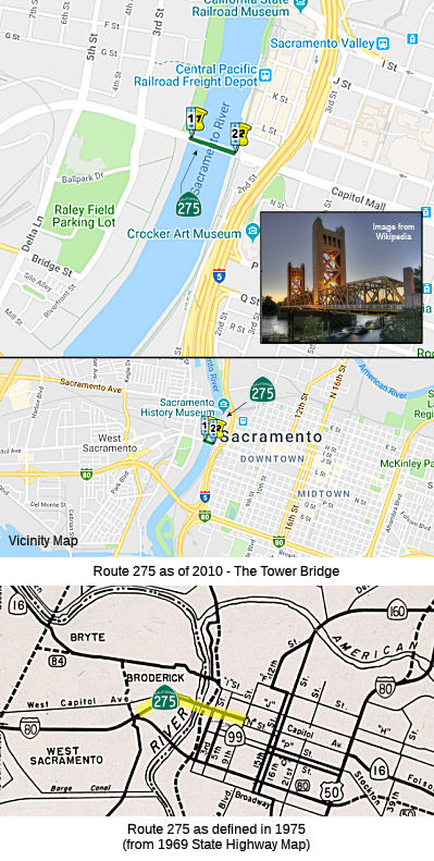 Tower Bridge from the west side of the Sacramento River near the City of West
Sacramento to the east side of the Sacramento River near the City of
Sacramento.
Tower Bridge from the west side of the Sacramento River near the City of West
Sacramento to the east side of the Sacramento River near the City of
Sacramento.
 Post 1964 Signage History
 In 1967, Chapter 1350 defined Route 275 as “Route 80 near
West Acres Road west of Sacramento to the junction of Capitol Avenue and
Ninth Street in Sacramento. No funds in the State Highway Fund shall be
used for the construction or maintenance of any further aesthetic
improvements on that portion of the route in the City of
Sacramento.” This routing of Route 275 was planned as a realignment
of Capitol Avenue. When I-80 was built, the old route was removed from the
state highway system, except for Route 275, which the legislature
specifically asked the highway department to keep until they could decide
whether this would be permanent (1966 Senate Concurrent Resolution 17,
chapter 94, p. 872).
In 1967, Chapter 1350 defined Route 275 as “Route 80 near
West Acres Road west of Sacramento to the junction of Capitol Avenue and
Ninth Street in Sacramento. No funds in the State Highway Fund shall be
used for the construction or maintenance of any further aesthetic
improvements on that portion of the route in the City of
Sacramento.” This routing of Route 275 was planned as a realignment
of Capitol Avenue. When I-80 was built, the old route was removed from the
state highway system, except for Route 275, which the legislature
specifically asked the highway department to keep until they could decide
whether this would be permanent (1966 Senate Concurrent Resolution 17,
chapter 94, p. 872).
The 1964 definition for Route 80 included the Tower Bridge, which
continued to be signed as part of I-80 until the completion of freeway
construction. By September 1964, the substructure of the Sacramento River
Bridge between W Street and X Street had been completed, with full
completion of the new I-80 bridge over the Sacramento River planned for
Summer 1966. In 1967 the new bridge was completed, which resulted in
movement of the I-80 designation to the new freeway and new bridge. At
this point, the legislature created Route 275 to retain the segment of
former US 40 and US 99W from I-80 along the West Sacramento River Freeway
east over the Tower Bridge towards the State Capitol (along Capitol Mall)
in the state highway system.
(Source: Gribblenation Blog (Tom Fearer), "The history of Sacramento's Tower Bridge (Currently California State Route 275 and former US Routes 40/99W)", 10/8/2025)
In 1972, Chapter 1216 changed "West Acres Road" to "Westacre Road".
In 1981, Chapter 292 changed "Route 80" to "Route 50", reflecting the renumbering of routes in Sacramento.
In 1996, Chapter 1154 deleted the route; however, the bridge was never relinquished.
In 2010, Chapter 421 (SB 1318, 9/29/10) added the route back, but just as the Tower Bridge. At 738 feet long, it is the shortest state highway in California.
According to the Caltrans GIS database in 2023, there is also a segment in W. Sacramento, from PM 11.7 to 12.04, with both an L and an R suffix, that is disconnected from the bridge portion and not yet relinquished. It constitutes the ramps from US 50 to Jefferson Blvd along the Tower Bridge Gateway.
 Pre 1964 Signage History
This was part of LRN 6, defined in 1909. It was one routing of old US 99W/US 40.
Originally, LRN 6 used the "I" Street Bridge (see the page on Route 24).
The I Street Bridge opened to traffic over the Sacramento River in 1912 as
a swing span carrying the Southern Pacific Railroad and highway traffic.
By 1917, LRN 6 departed Sacramento westward via the I Street Bridge to
Washington (now West Sacramento). Prior to the construction of the Yolo
Causeway, a primitive seasonal road known as "Tule Jake Road" could be
utilized to traverse Yolo Basin by car between West Sacramento and Davis
(seasonal, as the Yolo basin flooded six to eight months every year).
After completion of the Yolo Causeway (then referred to as the Yolo Basin
Trestle) between West Sacramento and Davis, LRN 6 was moved to the "M"
Street Bridge, which eliminated a rail overpass from the alignment. In
1935, the "I" Street Bridge became part of LRN 50 as part of the 1935
codification of LRN 50 as "[LRN 15] to Sacramento via Rumsey and Woodland"
(previously, LRN 50 had ended in Woodland); the "I" Street Bridge was then
signed as part of Sign Route 16 and Sign Route 24.
(Source: Gribblenation Blog (Tom Fearer), "The history of Sacramento's Tower Bridge (Currently California State Route 275 and former US Routes 40/99W)", 10/8/2025)
The M Street Bridge was originally constructed as a railroad swing
structure in 1911. The M Street Bridge was utilized by the Sacramento
North Railway, Oakland Antioch & Eastern Railway and Northern Electric
Railway. The construction of LRN 6 and the Yolo Causeway saw roadway
lanes added to the M Street Bridge as part of the realignment of the
highway. In 1925, a fire that destroyed the existing Sacramento Northern
Railroad Subway on LRN 6 in West Sacramento, and bids were put out by the
State to construct a new subway and eliminate a blind curve. By 1927, the
subway had been completed and it connected to a completed M Street Bridge
approach in West Sacramento, providing a new alignment of US 99/US 40/LRN 6 through the 1926 Sacramento Northern Railroad Subway. In 1934, the Tower
Bridge (future Route 275) opened. The Tower Bridge was a direct
replacement for the previous M Street Bridge. During the process of
construction of the Tower Bridge the M Street Bridge was removed and US 99W/US 40/LRN 6 crossed the Sacramento River via a temporary
structure. Unlike the swing design of the M Street Bridge, the
design of the Tower Bridge features a vertical lift span. The Tower Bridge
was originally silver in color when the structure was complete.
(Source: Gribblenation Blog (Tom Fearer), "Former US Route 99 West from West Sacramento to Red Bluff", August 2021)
The M Street Bridge was built in 1911 and was a swing-through truss
railroad bridge owned by the Sacramento Northern Railway. The M Street
bridge had a superstructure composed of triangular units known as trusses,
and could be rotated horizontally to allow the passage of maritime traffic
on the Sacramento River below. The M Street Bridge was later modified to
also allow motor vehicles to travel across it. Nine-foot roadway sections
were added as cantilevered sections on both sides of the existing rail
bridge. Sacramento’s population more than doubled between 1910 and
1935, and by the early 1930s, the M Street Bridge was inadequate for the
ever-growing volume of automotive traffic. In 1933, the city realized that
it needed a better crossing over the Sacramento River.
(Source: Freightways Classic, 7/20/2022)
Beginning on December 22, 1933, the State of California, Sacramento
County, and the Sacramento Northern Railway held meetings to plan the new
bridge. An agreement was reached among the parties on March 8, 1934. Under
the terms of that agreement, Sacramento Northern Railway gave up its
rights to the M Street Bridge in return for the rights to rail traffic
over the new bridge until March 21, 1960 (the original expiration date of
its franchise to operate rail traffic over the M Street bridge). The new
bridge was designed as a span-driven vertical lift bridge. This bridge
type is movable – designed for areas through which large ships
travel on a regular basis. A vertical lift bridge’s span can be
elevated vertically while remaining parallel with the structure’s
deck. The bridge’s towers are 160 feet high. From east to west, the
bridge consists of a 30-foot-long girder span, a 167-foot long eastern
truss approach span, a central lift span that is 209 feet long, a
193-foot-long western approach span and four 34-foot-long girder spans.
With the draw up, there is “100 feet of vertical clearance above
high water with a 172-foot-wide navigation channel between the timber pier
fenders.” The bridge’s lift span weighs 1,040 tons; however,
the use of an equal amount of counterweights (which are located in each
tower) allows the span to be operated with two relatively small
100-horsepower electric motors. The bridge was initially designed with a
52-feet wide roadway with sidewalks, with single lanes for vehicles that
flanked the 13-foot center lane for rail traffic. The bridge was designed
under the guidance and supervision of architect Alfred Eichler. He
developed the bridge’s appearance, which bridge engineers then
designed. Eichler’s design elements included completely hiding the
bracing on the tower posts by using decorative solid metal panels. These
panels also hide the counterweight and the counter chains. The faces of
the towers have an ‘x-bracing’ that has been carefully
designed so that from the exterior, a flat surface is visible, hiding the
flanges and webs of the actual bracing. The top of the tower face has
vertical openings. The very tops of the tower are capped with steel that
hides most of the sheaves and matches up with the other covers on the
towers. The bridge’s tender house doubles as the machinery room and
is a low-lying structure with a decorative cupola positioned on top of the
lift span. The lift span and approach truss spans are distinguished by a
minimalized use of lattice and v-lacing. The other key distinguishing
feature in the trusses is the portal and sway bracing that is a unique
arched design. Original ornate riveted lighting is present on the bridge.
The approaches to the bridge have two pairs of concrete pillars, with the
outermost pair bearing a casting of ‘1935’ at the top.
(Source: Freightways Classic, 7/20/2022, utilizing material from the page on the Tower Bridge at HistoricBridges.org)
Construction of the bridge began on July 20, 1934 and it was finished
less than 18 months later. On November 7, 1935 the first train crossed the
Tower Bridge. On Sunday, December 15, 1935, California Governor Frank F.
Merriam dedicated the bridge. The bridge was formally accepted by the
state on January 11, 1936. Tower Bridge was the first vertical lift bridge
in California’s highway system. The bridge’s railroad tracks
were removed in 1963. Following their removal, the roadway was renovated
to four lanes of automotive traffic. Because of the nearby railroad
tracks, the bridge’s east grade crossing is designed as a secondary
barrier to exclude vehicular traffic while the bridge is raised. When the
warning siren sounds, the crossing activates, blocking traffic until the
bridge is safe for use. From 1963 until 2007, the bridge was used for
pedestrian and vehicle traffic only. In 2007, the area’s regional
transportation agencies considered adding trolley traffic across the
bridge. However, no action was taken until 2020, when those plans were
changed. On September 15, 2020 the board of directors of the Sacramento
Regional Transit District voted in favor of using Tower Bridge to extend
the light rail system to provide service to West Sacramento.
(Source: Freightways Classic, 7/20/2022)
In 1954, the West Sacramento Freeway opened. The West Sacramento
Freeway was designed with future provisions to build an additional bridge
over the Sacramento River, permitting US 40 and US 99W to serve as a full
bypass of downtown Sacramento. The West Sacramento Freeway had an
eastern terminus at the Tower Bridge. The West Sacramento Freeway replaced
what is now Capital Avenue in West Sacramento. In 1961, the freeway
alignments for US 40, US 99, and what would become I-80 through Sacramento
were adopted. This moved the freeway off the West Sacramento Freeway and
the Tower Bridge; however, the Tower Bridge was planned from this point to
be retained as a funnel towards the State Capitol grounds. The last
train to crossing of the Tower Bridge would occur in 1962. The
tracks were removed from the structure in 1963.
(Source: Gribblenation Blog (Tom Fearer), "The history of Sacramento's Tower Bridge (Currently California State Route 275 and former US Routes 40/99W)", 10/8/2025)
Note: the Gribblenation Blog, "Highways in and around Old Sacramento; US 40, US 99W, CA 16, CA 24, CA 70, CA 99, CA 275, and more" provides a detailed history of the various highways (US 40, US 99, Route 16, Route 24, Route 70, Route 99, Route 275, Route 51, I-5, and I-80 in the Old Sac area.
 Status
In December 2003, after much of the route was deleted from the system, CalTrans construction signage at the corner of 3rd Street and West Capitol Avenue advised motorists to "Use SR 275" due to road work on West Capitol Avenue. It is likely that, although unsigned, the route has not yet been relinquished. The Tower Bridge is part of the riverfront revitalization in that area, and will likely be getting significantly wider sidewalks. The goal is to have promenades and trails lining both sides of the river, from Lighthouse Marina to Stone Lock in West Sacramento; from Discovery Park to Miller Park in Sacramento. There would be a deck over I-5 on the Sacramento side to reconnect the city to the riverfront.
Non-Bridge Portions
According to Chris Sampang, the portion of Route 275 that was part of the West Sacramento Freeway (from US 50/Route 84 east to the Tower Bridge near Raley Field) was reliniquished in 2001, five years after decomissioning, in order to convert several interchanges (3rd Street/West Capitol Avenue, 5th Street/West Capitol Avenue) into intersections. No work has begun on this however. The route, however, remained in the state highway code post-decomissioning (explaining why the lone Caltrans sign on West Capitol near Raley's Supermarkets headquarters mentions the highway). The Capitol (Avenue) Mall portion of Route 275 (from the I-5 overpass east to 9th Street, where US 99W, Route 16, and US 40 used to turn right to hit up N Street) was relinquished in 1999 to the city of Sacramento, and the only signs of former state maintenace are the old gantries for Route 99/Route 70/Route 16 and I-5 present in the area. There are plans for 5th Street to be extended S across the Route 275 West Sacramento Freeway as part of future improvements (and development in the Triangle area, the space between South River Road, Route 275, and US 50 where Raley Field is located). This will likely come with the downgrading of access control for the old freeway.
According to the Sacramento Bee, construction on the downgrading of former Route 275 will likely begin in 2005 with the removal of the Riske Lane interchange (Riske Lane will be renamed Garden Street afterwards); the money used for this project will be from local development funds. The removal of the interchanges at 3rd Street/South River Road and 5th Street will occur in 2008, after the old railroad line at the South River Road exit is removed. This will provide for more access to the Triangle/Raley Field area.
In July 2006, West Sacramento initiated the Tower Street Gateway project. This relates to the two-mile stretch of former Route 275 running through West Sacramento, dividing three neighborhoods and making it a challenge to get around town. The city plans to turn former Route 275 (which acts as a freeway on-ramp connecting Route 50 and Tower Bridge) into an arterial boulevard with three traffic lights. In early August 2006, the city advertised for bids to construct the first phase of the project, involving tearing down the Riske Lane freeway overpass and installing a signal. Construction is expected to begin in Fall 2006. The city believes that by transforming the old highway into a boulevard the city will become more accessible to residents and visitors who might otherwise drive quickly past it.. Route 275 divided three neighborhoods -- Washington, the Triangle, and West Capitol Avenue and the downtown -- from one another. All three areas are in the midst of "aggressive urban revitalization. Work to better link the neighborhoods will begin at Riske Lane. That road will become Garden Street and ultimately link West Capitol Avenue to a future network of streets south of the Tower Bridge Gateway. About half the cost of the first phase of the project, or $3 million, will be paid for by a Community Design Program grant from the region's transportation planning agency, the Sacramento Area Council of Governments. The balance will be paid with redevelopment agency money and some federal funds. The project's second, and final, phase calls for stoplights on the Tower Bridge Gateway at the intersections of 3rd and 5th streets. Third Street goes under the gateway and, like Riske Lane, plans call for making that an intersection, too. The second phase is contingent upon funding.
According to Chris Sampang, as of January 2011, construction work has begun on the reconstruction of the Tower Bridge Gateway (former West Sacramento Freeway) - the old overpass crossing 3rd Street near Raley Field has now been demolished.
However, not all has been relinquished yet. In March 2005, the CTC considered relinquishment of a portion of Route 275 right of way in the City of Sacramento. They considered it again in April. And again in July 2005, together with a financial SHOPP project: In Sacramento at the east abutment of the Tower Bridge to 9th Street. Relinquish highway to the City of Sacramento.
In July 2010, the CTC approved for future consideration of funding a project that would convert the Tower Bridge Gateway (formerly Route 275) from a freeway to a city street from the Union Pacific Railroad (UPRR) Underpass to the Tower Bridge, a length of 1,700 feet. The project will remove the Third Street Undercrossing and will provide new, at-grade, signalized intersections at Fifth Street and Third Street. Impacts and mitigation measures related to areas of earth, air quality, water resources, plant life, animal life, noise, light and glare, land use, hazards, circulation, public services, energy, utilities, human health, and aesthetics were implemented by the City. The project is estimated to cost $8,789,000 and is programmed with SLPP ($1,000,000) and Local ($7,789,000) funds. Construction is estimated to begin in fiscal year 2009/10. On June 10, 2010, the City confirmed that the project scope in the MND as modified by the addendum is consistent with the project scope programmed by the Commission.
Note that the segment from Jefferson Street W to US 50 remains part of Route 275.
Tower Bridge
According to Joe Rouse, the bridge itself will remain owned and operated by Caltrans. Before Route 275 was re-created in 2010, the notion was that as legislatively Route 275 wouldn't exist anymore, the bridge may not carry a route number (which would make it an anomaly in the system once the relinquishment of the highway on either side is complete). It is unclear if the bridge is currently signed.
In July 2014, it was reported that Caltrans was looking
again to give away the Tower Bridge. As of July 2014, Sacramento owned the
portion of Capitol Mall that leads to the bridge on the east, and West
Sacramento owned the portion of the Tower Bridge Gateway that leads to the
bridge on the west. The state only owned the 737-foot bridge. Giving up
the bridge was actually Caltrans' idea. The organization sent letters to
both cities making the offer, citing permit red tape. Caltrans is offering
to complete an $8.5 million restoration project on the bridge fenders and
maintain it for five years after the cities take control. Sacramento will
vote on a memorandum of understanding to continue negotiations in late
July 2014, while West Sacramento isn't close to anything formal yet. An
agreement would have be reached between both cities to operate and
maintain the bridge. The earliest local jurisdictions would take control
of the bridge is 2018, and local funds wouldn't be needed until at least
2023. Annual operating and maintenance costs are about $400,000.
(Source: ABC News 10, 7/22/14)
In March 2016, the CTC approved for future consideration of funding a project in Yolo County that will remove and replace the fender system surrounding Pier 6 and Pier 7 of the Tower Bridge on Route 275 between the cities of West Sacramento and Sacramento. The project is programmed in the 2014 State Highway Operation and Protection Program. The total estimated cost is $10,821,000 for capital and support. Construction is estimated to begin in Fiscal Year 2017-18. A copy of the MND has been provided to Commission staff. The project will result in less than significant impacts to the environment after mitigation. The following resource areas may be impacted by the project: biological resources, cultural resources, hazardous materials, and water quality. Avoidance and minimization measures will reduce any potential effects on the environment. These measures include, but are not limited to, the use of sound attenuation devises, environmental awareness training for all construction personnel, new fender replacements matched with the design and appearance of the old fenders, appropriate BMPs for water pollution prevention, and the implementation of an approved Water Pollution Control Program. As a result, an MND was completed for this project.
In October 2018, it was reported that a $6 million
project has started on the Tower Bridge. The 82 year old bridge is
sagging: Bridge inspectors last year noticed the cables that help lift the
main span for tall ships have stretched 14 inches longer than they once
were – a sign that time, weather, and stress have taken a toll. A
project has started to replace the cables. The project, which includes a
handful of other upgrades, continues through December 2018 and is
requiring daily traffic-lane reductions and several full-bridge nighttime
closures. The work focuses on cutting and replacing, one at a time, 96
steel cables that connect the lift deck to two 1 million-pound
counterweight blocks that are suspended high inside each of the
span’s twin towers. Those counter-weight blocks slowly lower, via a
second cable system, as the bridge deck rises, providing a weight
balancing role. The state could have let the cables remain as is, but took
action partly because officials feared potential deterioration inside the
nearly 2-inch-thick cables. The project work includes redoing electrical
cables and lights, and upgrading security and communications systems. The
bridge is owned by Caltrans and sits on Route 275, the shortest highway in
California, running from one end of the bridge to the other. The state
relinquished the rest of that highway more than a decade ago to West
Sacramento on one side and Sacramento on the other.
(Source: Sacramento Bee, 10/29/2018)
In the Summer 2019 issue of Mile Marker, it
was reported that Caltrans is also planning repairs to the Tower Bridge,
opened in 1935. In addition to the earlier work, an emergency contract is
awaiting approval to replace the main mechanical drive system, electrical
control system, add back-up controls, and replace worn bearings and
balance chains. Caltrans expects to spend another $5 million overall on
the Tower rehabilitation effort. The Tower Bridge is a verticle lift
bridge (one of three in the system) that sees 16,500 vehicle trips daily
(on average).
(Source: Summer 2019 Mile Marker)
 Naming
The portion of former Route 275 that extends from the end of the Sacramento River Bridge in the City of Sacramento to the junction of Capitol Avenue and Ninth Street in Sacramento is officially named the "Capitol Mall". Named by California Government Code §8167. (March 1977)
The freeway (formerly the easternmost segment of the West Sacramento Freeway) has officially been renamed the "Tower Bridge Gateway" although no signs exist yet to this effect. It was probably renamed by local ordinance.
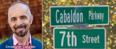 The Tower Bridge Gateway in West Sacramento, between Capitol Mall and US 50/Business Route 80, was renamed to Cabaldon Parkway in November 2024. The
change honors Christopher Cabaldon, who was the mayor of West Sacramento
for several years and oversaw major changes to the city. In 2024, Cabaldon
was elected to the California State Senate, representing the people of
Wine Country, the Delta, the North Bay, and the Sacramento Valley who make
their home in the 3,000 square miles of the Third Senate District. Before
his election to the Senate, he served two decades as Mayor of West
Sacramento in Yolo County. During his long tenure as Mayor, West
Sacramento won the national designation as America’s Most Livable
Small City. It was the first city in the nation to implement universal
preschool, college savings accounts for all kindergarteners, paid
internships for high school students in college-and-career pathways, free
community college and automatic college admission letters to every local
graduating senior. Senator Cabaldon represented California on the Western
Interstate Commission on Higher Education prior to his election to the
Senate. He served previously as vice chancellor of the California
Community Colleges and director of the higher education committee for the
State Assembly. He was national president for Asian and Pacific Americans
in Higher Education, and president of the Linked Learning Alliance.
Cabaldon chaired the Jobs, Education & the Workforce Committee for
America’s mayors, and represented the United States in the Global
Parliament of Mayors. As chair of the Sacramento region’s
metropolitan planning organization and its transportation committee, his
pioneering work on integrating transportation, land use, environmental
justice, housing, air quality, and climate change won numerous national
awards, and became the basis for some of California’s most sweeping
transportation and climate reforms of the past two decades. He served on
the Central Valley Regional Water Quality Control Board and the state
Delta Protection Commission. Senator Cabaldon is the first Filipino
American ever to serve in the California Senate, and the first LGBTQ
Senator elected north of San Francisco and Stockton. As a child, he was a
pioneering student at the first magnet school in California created to
reverse racial segregation in the school district. As an adult, his coming
out journey was the subject of an episode of the LOGO network’s
internationally-syndicated Coming Out Stories series.
The Tower Bridge Gateway in West Sacramento, between Capitol Mall and US 50/Business Route 80, was renamed to Cabaldon Parkway in November 2024. The
change honors Christopher Cabaldon, who was the mayor of West Sacramento
for several years and oversaw major changes to the city. In 2024, Cabaldon
was elected to the California State Senate, representing the people of
Wine Country, the Delta, the North Bay, and the Sacramento Valley who make
their home in the 3,000 square miles of the Third Senate District. Before
his election to the Senate, he served two decades as Mayor of West
Sacramento in Yolo County. During his long tenure as Mayor, West
Sacramento won the national designation as America’s Most Livable
Small City. It was the first city in the nation to implement universal
preschool, college savings accounts for all kindergarteners, paid
internships for high school students in college-and-career pathways, free
community college and automatic college admission letters to every local
graduating senior. Senator Cabaldon represented California on the Western
Interstate Commission on Higher Education prior to his election to the
Senate. He served previously as vice chancellor of the California
Community Colleges and director of the higher education committee for the
State Assembly. He was national president for Asian and Pacific Americans
in Higher Education, and president of the Linked Learning Alliance.
Cabaldon chaired the Jobs, Education & the Workforce Committee for
America’s mayors, and represented the United States in the Global
Parliament of Mayors. As chair of the Sacramento region’s
metropolitan planning organization and its transportation committee, his
pioneering work on integrating transportation, land use, environmental
justice, housing, air quality, and climate change won numerous national
awards, and became the basis for some of California’s most sweeping
transportation and climate reforms of the past two decades. He served on
the Central Valley Regional Water Quality Control Board and the state
Delta Protection Commission. Senator Cabaldon is the first Filipino
American ever to serve in the California Senate, and the first LGBTQ
Senator elected north of San Francisco and Stockton. As a child, he was a
pioneering student at the first magnet school in California created to
reverse racial segregation in the school district. As an adult, his coming
out journey was the subject of an episode of the LOGO network’s
internationally-syndicated Coming Out Stories series.
(Source: KCRA 11/6/2024; Christopher Cbaldon Biography on SD3 page, 3/22/2025)
According to research done by Chris Sampang, the name "Capitol Avenue" was first used on October 26, 1940. Previously, the street was "M Street".
 Named Structures
 Other WWW Links Status
This routing was never signed. It is constructed to freeway standards from Route 50 to the Tower Bridge.
 Classified Landcaped Freeway
The following segments are designated as Classified Landscaped Freeway:
| County | Route | Starting PM | Ending PM |
| Yolo | 275 | 11.70 | 13.01 |
 National Trails
 The third iteration of the Lincoln Highway was routed out of Sacramento to the West along LRN 6 (including Route 275) and LRN 7.
It diverted to use Route 12 (LRN 8) and Route 29 (LRN 74) to return to LRN 7 near Vallejo, where it met LRN 14 to LRN 5, where it then crossed into
San Francisco (originally via the Ferry, and later the Oakland Bay Bridge
on LRN 68). The route originally terminated in Lincoln Park, six miles
west of the ferry landing at the foot of Market Street. The Lincoln
Highway ended opposite the Palace of the Legion of Honor at a small
monument marking the spot. The last few miles (of the highway) were
California Street.
The third iteration of the Lincoln Highway was routed out of Sacramento to the West along LRN 6 (including Route 275) and LRN 7.
It diverted to use Route 12 (LRN 8) and Route 29 (LRN 74) to return to LRN 7 near Vallejo, where it met LRN 14 to LRN 5, where it then crossed into
San Francisco (originally via the Ferry, and later the Oakland Bay Bridge
on LRN 68). The route originally terminated in Lincoln Park, six miles
west of the ferry landing at the foot of Market Street. The Lincoln
Highway ended opposite the Palace of the Legion of Honor at a small
monument marking the spot. The last few miles (of the highway) were
California Street.
 The portion of this route between Oakland and Sacramento (LRN 6, LRN 7 and LRN 14) part of the National Park to Park Highway.
 Statistics
Overall statistics for Route 275:
 Pre-1964 Legislative Route
In 1959, Chapter 1062 defined LRN 275 as “[LRN 26] to [LRN 190] near Mountain View Avenue” This was a transfer of the former Colton-San Bernardino connection from LRN 26. This was part of the 1963-1965 definition of segment (a) of Route 18, from I-10 to (then) Route 30 (present-day Route 210) near Mountain View Avenue.
© 1996-2024 Daniel P. Faigin.
Maintained by: Daniel P. Faigin
<webmaster@cahighways.org>.
 Route 274
 Route 276