
 California Highways:
Click here for a key to the symbols used. An explanation of acronyms may be found at the bottom of the page.
 Routing
 Post 1964 Signage History
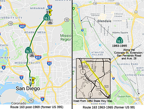
1963-1965 Routing in Los Angeles
 In 1963, Route 163 was defined as "Near Lacy Street and Avenue 26
to Route 5 in Los Angeles." This was a small segment of old US 99 that appeared to run along the old US 99
routing to the old Route 134 routing, where it then went to I-5.
In 1963, Route 163 was defined as "Near Lacy Street and Avenue 26
to Route 5 in Los Angeles." This was a small segment of old US 99 that appeared to run along the old US 99
routing to the old Route 134 routing, where it then went to I-5.
 In 1965, Chapter 1372 deleted this routing. For a long time, it was still signed in one place: on Avenue 26 crossing Route 110.
Post-1969 Routing in San Diego
In 1969, Chapter 294 added a new routing for Route 163 (using a
transfer from Route 395): "San Diego to Route 15 near United States Naval
Air Station, Miramar and westerly of Route 15." When this was US 395, a
portion was cosigned with US 80.
In 1984, Chapter 409 the routing was clarified: "Route 5 near Balboa
Park in San Diego to Route 15 near United States
Miramar Naval Air Station, Miramore and westerly of Route 15".
According to Andy Field, the portion from Route 5 to San Diego was originally going to connect with an interchange linking it to Route 94. He notes that a sign on SB Route 163 approaching I-5/Fourth Avenue/Park Boulevard was modified in 1999 to eliminate a reference to Route 94. His research showed that the original freeway plans called for Route 163 to continue as a freeway south of I-5 (which it did until 1984) until the area around F and G Streets. At that point, according to Andy, the freeway was intended to turn east to connect to the existing Route 94 freeway. The Floodgap site notes that Market St was cosigned US 395/Route 94 apparently in the late 1940s after the US 80 river routing was established and Route 94's routing consequently moved a couple blocks south. By 1972, this stretch was signed as Route 163, but Route 94 was also signed.
Additionally, on Route 163 South in San Diego, just as it connects to I-5, there is a stub of a ramp that comes from nowhere above the ramp off of Route 163 (just below the old city fire alarm reporting building) that would have connected to nothing in Balboa Park. This stub ramp was part of the planned but unconstructed expansion of CA 163 from four to eight lanes of freeway. The expanded freeway was canceled due to concerns about Balboa Park and the aesthetics of the freeway (local opposition). The concrete stub is all that remains of that planned expansion.
An article in San Diego Magazine, 9/16/1965 (when it was still US 395) goes into more
detail on the freeway plans and the revolt. Through the work of a group
called Citizens Coordinate (formed in 1961), the route was retained as a
scenic freeway. The argument for widening US 395 (Route 163) between I-5
and I-8 were based on weekday and projected traffic volumes. The Division
of Highways planned to purchase and dedicate to the city land contiguous
to Balboa Park equivalent to the acreage needed to widen the freeway. This
would have kept the park the same size. With respect to alternate routes,
the Division of Highways contended that "that even with complete
development of the planned network of freeways, “the growth of
traffic desires” will still require eight lanes through Balboa Park.
Such widening will enable many more persons—namely, the
motorists—to enjoy the park through the aesthetic experience of
driving along a landscaped freeway". The Division of Highways argued that
beauty of the freeway, including its present center parkway, would be
maintained by a plan of split-level roadways which would actually create
two additional medians for further landscaping. They noted that those who
cried havoc when park land was taken for the interchange network at the
southern end of Cabrillo Freeway found their fears groundless after the
State Division of Highways restored greenery to the raw cuts. An
extensively researched rebuttal by Citizens Coordinate showed that, since
1870, when the Legislature declared the 14oo acres of Balboa Park land to
be held in trust forever for purposes of a “free and public park and
for no other or different purpose,” 322.5 acres have been removed,
109 acres alone for State highway rights. They were sceptical of the
state’s promise to replace the lost land with land contiguous to the
park, and the state admitted they didn't know exactly what land would be
acquired. CC pointed out that compensation for land used several years ago
in building the I-5 interchange at the south end of Cabrillo Freeway
consisted of fill for three parking lots, near Balboa Park Bowl, near the
Zoo and in front of the Naval Hospital, all developed at city
taxpayers’ expense.
(Source: San Diego Magazine, 9/16/1965)
Atlas Obscura expands on the unbuilt freeway, noting that in the 1960s, San Diego proposed to expand Route 163, the Cabrillo Freeway, through Balboa Park to an 8- to 10-lane freeway. Public protest stopped the freeway from expanding more than its existing four lanes, but not before a portion of the Route 163/I-5 freeway connection began construction. The built portion would have extended north over a pedestrian walkway. The stub is still visible today from the Bridle Trail in Balboa Park and connects to the Route 163/I-5 interchange, modeled after the “Four Level” US 101/Route 110 interchange in Los Angeles.
The route's original 1948 freeway section extended from the 10th-11th Street Split to the Friars Road junction. The Route163 designation was posted in 1969, but the US 395 designation remained posted up until 1973; and extended south along 10th/11th Street to Market, turned west and ended at Harbor Drive.
Historical Oddity: Coming north out of downtown San Diego on 11th Street (at the south end of Route 163, just south of I-5) there is a sign that says something like "Historic Route 163 Cabrillo Freeway" and shows a black on white 1957-1964 Route 163 shield. The odd thing here is that this route was designated as Route 163 in the late 1960s, so it never was signed with the old black on white shield; the historic route was actually US 395. The designation come from AB 3025 in March 2002. This bill stated:
That part of the California highway system frequently referred to as the Cabrillo Freeway, which is the segment of State Highway Route 163 between postmiles 0.5 and 3.0 through Balboa Park in the City of San Diego, is hereby designated a California Historic Parkway and is named the Cabrillo Parkway."
The portion of Route 163 has been found to be eligible for inclusion in the National Register of Historic Places. That happened in 1996. The corridor management plan (CMP) notes:
The CMP roughly corresponds with the limits of the Cabrillo Freeway National/California Register Historic District. The Cabrillo Freeway Historic District was found eligible for the National Register of Historic Places and for placement on the California Register of Historical Resources in December 1996 as a result of research done on Route 163 for federally funded seismic retrofit projects that were being proposed at the time (Rosen 1996, 1997). Frank Lortie and Dorene Clement (1996), California Department of Transportation (Department) architectural historians, prepared the study documenting the historical importance of the freeway and its contributing elements. The Historic Property Survey Report (HPSR) that included the Lortie and Clement report was submitted to the Federal Highway Administration (FHWA) and the State Historic Preservation Officer (SHPO) in November 1996 (Rosen 1996). Eligibility of the Historic District was confirmed by FHWA on November 22, 1996, and by the SHPO on December 20, 1996 (Attachment 1). The Historic District includes a 2.6km (1.6mi) segment of Route 163, from roughly 90m (300ft) south of the Cabrillo Bridge, to a point just south of the 6th Av. on-ramp Undercrossing (UC); the east and west boundaries of the Historic District are the Department’s right-of-way limits. The contributing elements to the Historic District include:
- The Roadway
- The Landscaping
- Cabrillo (AKA Laurel Street) Bridge, #57-0215, 11-SD-163, P.M. 1.42, built in 1915
- Quince Street Overcrossing (OC), Bridge #57-0216K, 11-SD-163, P.M. 1.62, built in 1947
- Richmond Street OC, Bridge #57-0217Z, 11-SD-163, P.M. 1.8, built in 1947
- Upas Street Pedestrian OC, Bridge #57-0218, 11-SD-163, P.M. 2.07, built in 1947
- Robinson Av. OC, Bridge #57-0219, 11-SD-163, P.M. 2.49, built in 1942
- University Av. OC, Bridge #57-0085, 11-SD-163, P.M. 2.61, built in 1947
- Washington Street OC, Bridge #57-0220, 11-SD-163, P.M. 2.75, built in 1942
- Washington Street/6th Av. Separation, Bridge #57C-0009 (City of San Diego bridge), P.M. 2.75, built in 1940
- Pascoe Street on-ramp OC, Bridge #57-0221, 11-SD-163, P.M. 2.79, built in 1947
Non-contributing elements to the Historic District include: Traffic signs, Median barriers, Guardrails, the 6th Av. on-ramp UC, Bridge #57-0222, 11-SD-163, P.M. 2.9, built in 1947, modified in 1979, the Route 8/163 Separation North, Bridge #57-0239F, 11-SD-163, P.M. 3.81, built in 1947, and the San Diego River Bridge, #57-0126, 11-SD-163, P.M. 3.95, built in 1946, modified in 1970. The latter three bridge structures, while included in the original Lortie and Clement evaluation, fall outside the limits of the Historic District. Subsequently, the City of San Diego Historical Resources Board listed the Historic District as local landmark #441 in September 2000. Then in August 2002 Governor Gray Davis signed legislation (AB3035§3.284) that officially designated the portion of Route 163 from PM 0.5/3.0 (KP 0.8/4.8) as the Cabrillo Historic Parkway. This section of Route 163 is also an officially designated California Scenic Highway.
 Pre 1964 Signage History
1963-1965 Routing in Los Angeles
The 1964-1965 routing of Route 163 was the original routing of US 99 between San Fernando Road and I-5. It was LRN 4.
Colorado Street Extension (Route 5S)
The Colorado Street Freeway Extension (Route 5S) opened
in 1958 as the Golden State Freeway (then US 99, US 6 and I-5) was being
constructed. The Colorado Freeway Extension would serve as a
temporary realignment of US 99/US 6 off of San Fernando Road and new
alignment of Sign Route 134. US 99 and US 6 followed the Colorado
Street Freeway Extension to San Fernando Road until the Golden State
Freeway was completed to the San Bernardino Freeway in 1962. The
Colorado Street Freeway Extension would be assigned as part of the
original 1964 incarnation of Route 163, but was quickly folded into a
Route 134 Spur by 1965. The corridor would be assigned as part of
Route 5S when the Ventura Freeway extension reached Route 2 (then at
Verdugo Road) in 1969. Note: The Colorado
Street Extension is a formally suffixed route in the Postmile System
(Route 5S), as opposed to having "S" postmiles (i.e., 07-LA-005 S0.0).
(Source: Gribblenation Blog (Tom Fearer), "The Colorado Street Freeway Extension (Interstate 5 Spur in Glendale and Los Angeles)", 2/2024)
As originally defined, Colorado Street ended at San
Fernando Road (US 99 / LRN 4) in the city Glendale. Colorado Street
became a component of LRN 161 in 1933 after the state began to allow the
Division of Highways to maintain State Highways in incorporated
cities. When sign routes were announced in 1934, Sign Route 134 westbound followed a multiplex of US 99/LRN 4 on San Fernando Road
from the end of Colorado Street in Glendale to Alameda Avenue in Burbank.
US 99 along San Fernando Road would be joined by an extended US 6
beginning in 1937. In 1955, construction began on the Golden State Freeway
corridor between the Santa Ana Freeway and Hollywood Freeway; this would
be an eventual rerouting of US 99/US 6/LRN 4, and the route would take it
through the cities of Glendale and Burbank. By 1958, the Colorado
Boulevard Interchange was under construction to connect Sign Route 134 via
LRN 4 to US 99/US 6 on the Golden State Freeway over the Los Angeles River
extending it from San Fernando Road in Glendale. By 1959, the Golden State
Freeway was completed between Alameda Avenue in Burbank south to Glendale
Boulevard in Los Angeles. US 99/US 6 followed an interim alignment on LRN 4 originating at San Fernando Road in Burbank, west on Alameda Avenue,
south on the Golden State Freeway and east on the Colorado Street Freeway
Extension to San Fernando Road in Glendale. Route 134 followed an
interim multiplex of US 99/US 6/LRN 4 on the Golden State Freeway between
Colorado Street north to Alameda Avenue. South of Colorado Boulevard
to Glendale Street, the Golden State Freeway was part of LRN 161. The
completion of the Golden State Freeway from Lankershim Boulevard to the
Santa Ana Freeway in 1962 resulted in the realignment of US 99 to follow
I-5/LRN 4 on the Golden State Freeway directly to the San Bernardino
Freeway, bypassing the Pasadena Freeway and Santa Ana Freeway through
downtown Los Angeles. At this time, the Colorado Street Freeway
Extension was a spur of LRN 4 and solely signed as Route 134. This
segment became part of Route 163, only to go away in 1965 when it became a
spur of Route 134. With the completion of the Ventura Freeway Extension
from I-5 east to Route 2 at Verdugo Road in 1969, Route 134 was rerouted
off of Colorado Street in downtown Glendale north on Route 2/Verdugo Road
to the new segment of the Ventura Freeway. The Colorado Street
Freeway Extension was renumbered as Route 5S (note: it is not I-5S, as it
was never a formal part of the Interstate system)
(Source: Gribblenation Blog (Tom Fearer), "The Colorado Street Freeway Extension (Interstate 5 Spur in Glendale and Los Angeles)", 2/2024)
Post-1969 Routing in San Diego
The post-1969 routing was the old US 395 routing, LRN 77, defined in 1931. At this time I-15 was defined to use the LRN 283 routing. The Route 163 routing was completed in 1948 as part of US 395. Surprisingly, Caltrans has seen fit to sign the route with a "historic" (i.e., black and white) Route 163 shield, even though it was never signed that way during that time period.
Route 163 was not defined as part of the initial state signage of routes in 1934. It is unclear what (if any) route was signed as Route 163 between 1934 and 1969.
Origins of the Cabrillo Freeway
The portion of Route 163 through Balboa Park (then
planned as part of US 395) started with a City Council vote, as a city
charter provision mandates that citizens vote anytime Balboa Park land is
developed for non-park purposes. The March 1941 vote resulted in an 8-1
win, allowing for a 200-foot-wide course through Cabrillo Canyon to be
used for the freeway. Construction began in 1942, when the state route was
just a dirt road and the section through Balboa Park was a lily pond. On
February 28, 1948, the route debuted as US 395/Cabrillo Freeway. In 1969,
it became Route 163.
(Source: San Diego Magazine, March 2016 (2/26/16))
Cabrillo Bridge (163-SD-1.417)
The Cabrillo Bridge was erected as a dramatic
916-foot-long entry into Balboa Park for the 1915 Panama–California
Exposition. Construction started in December 1912 and was carried out
mostly by hand. Over a million board feet of redwood was used and 270,000
tons of concrete poured. It was declared complete on April 13, 1914, when
San Diego Mayor Charles F. O’Neill and Franklin D. Roosevelt, then
assistant secretary of the Navy, made the inaugural drive over. The bridge
was reserved only for pedestrians in its first two years, but special
exceptions were made for dignitaries. Architects Frank Allen Jr. and
Bertram Goodhue designed the bridge. Goodhue proposed a three-arch design
possibly inspired by bridges in Toledo or Alcántara, Spain, but it
was $7,000 over the approved $150,000 budget. Instead, Allen’s
on-budget seven-arch proposal was approved. With designer Thomas Hunter
and some direction from Goodhue, Allen proceeded with
construction—and by the end had overspent by more than $70,000.
Goodhue also wrote a letter claiming Allen had taken more credit for the
architecture than was due. The first update to the bridge came in 1950
with the addition of a wrought-iron fence to deter suicide
jumpers—and protect drivers from them. Since the turn of the
century, the most maintenance has occurred in the redwood frames of the 14
pillars, which have proven to be a fire hazard. The pillars’ hollow
interior has frequently attracted homeless people looking for shelter, and
accidental fires likely caused by them broke out in 1951, 2004, and again
in April 2019. The old wood has since been replaced and the structure
earthquake-proofed and uplit so the bridge shines brightly at night.
Caltrans and the city are tasked with the usual upkeep: patching up
concrete from salt erosion, removing ivy, and covering up graffiti. The
terrain below the bridge has been relandscaped twice since the
bridge’s construction. First came a manmade lagoon in 1915 to lend
the structure a reflection. But mosquitoes were quick to infest the
lily-pad-covered waters and it had to be significantly drained. The city
scrapped the shallow pool completely in 1948 when the 7.1-mile US 395/Cabrillo Freeway was laid.
(Source: San Diego Magazine, August 2019 (7/24/19))
 Status
In June 2023, the CTC amended the following SB1 project in the 2022 SHOPP
as follows: 11-SD-163 1.6/2.8. PPNO 11-1276; ProjID 1117000171; EA
43013. Route 163 In the city of San Diego, at various locations from
Quince Street Overcrossing Bridge № 57-0216K to Washington
Street Overcrossing Bridge № 57 -0220. Replace bridge rail
within Cabrillo Freeway Historic District. Note: Delete
project. The no-build option has been chosen, as environmental
studies would take an additional six years, the designs studied would
jeopardize the historic status of the bridges, and crash data does not
justify upgrading the railings to concrete barriers. The department will
monitor the structures and address any critical deficiencies.
(Source: June 2023 CTC Agenda, Agenda Item 2.1a.(1e) #1)
Friars Road/Route 163 interchange (~ SD 4.39)
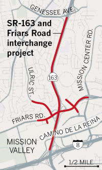 In May 2017, it was reported that the San Diego City Council approved money for
long-awaited upgrades to the Friars Road/Route 163 interchange. The
upgrades to Friars and Route 163, projected to cost $41.2 million, are
scheduled to begin in Fall 2017 and take two years to complete. The state
Department of Transportation, or Caltrans, will oversee this project,
although the city is paying the entire cost. The project will include new
freeway ramps, additional turning lanes and modern stoplight timing
systems. In addition to improving traffic flow between Friars and Route 163, the project aims to alleviate congestion on Friars near Fashion
Valley mall at Ulric Street and near Hazard Center at Frazee Road. The
project, initially planned about 14 years ago, was delayed by a thorough
environmental analysis completed in 2010. The city then struggled to reach
deals with 11 property owners who control land needed to make way for the
upgrades. Construction bids for the project came in much higher than
projected, forcing the City Council to increase funding from $32.3 million
to $41.2 million. In addition to road construction, the project will have
bicycle lanes and new sidewalks. The road work will include eliminating
the Friars Road West off-ramp from northbound Route 163, which creates a
merging and weaving situation that often leads to congestion. When the
project is complete, drivers will loop under the freeway and access Friars
Road West at a stoplight at the top of the ramp on Friars. At southbound
Route 163 and Friars, where drivers have been forced to exit via one lane
that gradually expands to three, crews will transform the interchange into
five lanes. The bridge over Route 163 will be widened and sound walls will
be constructed. Southbound Ulric’s intersection with Friars will
also be expanded. There will still be two lanes devoted to eastbound
Friars, but the number of lanes devoted to westbound Friars will increase
from one to two. At Frazee, Friars will be widened for an additional
through lane and one more turning lane into Hazard Center in both
directions. In addition, timed stoplights will be replaced by adaptive
signals, which can adjust green and red lights based on unpredictable
events that have suddenly altered traffic flow, such as patrons from a
sold-out movie flowing from a theater after the show. Caltrans and the
city have planned two additional phases of this project when funding
becomes available. They include a new collector ramp from southbound Route 163 to westbound I-8, a new flyover entrance ramp from Ulric to southbound
Route 163 to reduce weaving, two southbound Route 163 auxiliary lanes from
Genesee Avenue to Friars Road, and a northbound Route 163 auxiliary lane
for vehicles entering from Friars. The total estimated cost of those two
additional phases is $71 million.
In May 2017, it was reported that the San Diego City Council approved money for
long-awaited upgrades to the Friars Road/Route 163 interchange. The
upgrades to Friars and Route 163, projected to cost $41.2 million, are
scheduled to begin in Fall 2017 and take two years to complete. The state
Department of Transportation, or Caltrans, will oversee this project,
although the city is paying the entire cost. The project will include new
freeway ramps, additional turning lanes and modern stoplight timing
systems. In addition to improving traffic flow between Friars and Route 163, the project aims to alleviate congestion on Friars near Fashion
Valley mall at Ulric Street and near Hazard Center at Frazee Road. The
project, initially planned about 14 years ago, was delayed by a thorough
environmental analysis completed in 2010. The city then struggled to reach
deals with 11 property owners who control land needed to make way for the
upgrades. Construction bids for the project came in much higher than
projected, forcing the City Council to increase funding from $32.3 million
to $41.2 million. In addition to road construction, the project will have
bicycle lanes and new sidewalks. The road work will include eliminating
the Friars Road West off-ramp from northbound Route 163, which creates a
merging and weaving situation that often leads to congestion. When the
project is complete, drivers will loop under the freeway and access Friars
Road West at a stoplight at the top of the ramp on Friars. At southbound
Route 163 and Friars, where drivers have been forced to exit via one lane
that gradually expands to three, crews will transform the interchange into
five lanes. The bridge over Route 163 will be widened and sound walls will
be constructed. Southbound Ulric’s intersection with Friars will
also be expanded. There will still be two lanes devoted to eastbound
Friars, but the number of lanes devoted to westbound Friars will increase
from one to two. At Frazee, Friars will be widened for an additional
through lane and one more turning lane into Hazard Center in both
directions. In addition, timed stoplights will be replaced by adaptive
signals, which can adjust green and red lights based on unpredictable
events that have suddenly altered traffic flow, such as patrons from a
sold-out movie flowing from a theater after the show. Caltrans and the
city have planned two additional phases of this project when funding
becomes available. They include a new collector ramp from southbound Route 163 to westbound I-8, a new flyover entrance ramp from Ulric to southbound
Route 163 to reduce weaving, two southbound Route 163 auxiliary lanes from
Genesee Avenue to Friars Road, and a northbound Route 163 auxiliary lane
for vehicles entering from Friars. The total estimated cost of those two
additional phases is $71 million.
(Source: San Diego U-T, 5/19/2017)
The Route 163 Project page (since taken down as part of a Caltrans website restructure) has more details on the goals of the project:
In September 2018, there were reports regarding
construction closures on Route 163. The construction closures were related
to the $40 million construction project to widen the overpass at Friars
Road on Route 163, fix freeway off-ramps and on-ramps and lower the height
clearance of the Friars Road overpass to 15 feet, according to Caltrans.
An auxiliary lane on southbound Route 163 just north of the Friars Road
off-ramp will also be constructed.
(Source: ABC 10 News, 9/13/2018)
At the end of November 2019, Caltrans tweeted that it
had completed the city street portion of this project. Construction crews
have been re-working the interchange between Route 163 and Friars Road
since 2017, and just before Thanksgiving 2019, the new and improved
roadway was unveiled. Friars Road and its overcrossing was widened to four
lanes. Crews added a southbound lane on Frazee Road between Murray Canyon
Road and Friars Road and a second left turn lane on eastbound Friars Road
to the northbound Route 163 on-ramp.New bike lanes, sidewalks, and traffic
signals were also added into the area. The construction was part of Phase
1 of the Route 163/Friars Road Interchange Project, according to Caltrans.
In total, the phase costs $40 million and is funded by the City of San
Diego. .
(Source: @SDCaltrans, 11/26/2019; NBCSan
Diego, 11/26/2019)
In September 2018, Caltrans leadworker William Casdorph, 57, fell to his
death about 50 feet off of a transition ramp on Route 163 where it crossed
over I-805 in Kearny Mesa, the California Highway Patrol reported to San
Diego news outlets. The accident occurred about 3 a.m. He is survived by
his wife and three daughters. Casdorph had worked for Caltrans for the
past 19 years. Caltrans in 2016 highlighted Casdorph in its employee
newsletter when he and a colleague rescued a blind and deaf Jack Russell
terrier that had been missing for two weeks in Mission Hills.
(Source: Merced Sun-Star, 9/19/2018)
 Naming
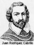 This route is named the "Cabrillo Freeway" from Route 5
to Route 15 (~ SD 0.949 to SD R11.056). Juan Rodríquez Cabrillo was
the leader of one of the first European expeditions to California. In
1542, Cabrillo led the first European expedition to explore what is now
the west coast of the United States. Cabrillo was commissioned by Pedro de
Alvarado, Governor of Guatemala, for a voyage up the California coast
under the flag of Spain. Cabrillo hoped to find the fabulously wealthy
cities known as Cibola, believed to be somewhere on the Pacific coast
beyond New Spain, and a route connecting the North Pacific to the North
Atlantic. Cabrillo reached "a very good enclosed port" which is now San
Diego bay, on September 28, 1542, naming it "San Miguel". He probably
anchored his flagship, the San Salvador at Ballast Point on Point Loma's
east shore. Six days later, he departed San Diego sailing northward and
exploring the uncharted coast line of California. The expedition reached
San Pedro on October 6, Santa Monica on the 9th, San Buenaventura on the
10th, Santa Barbara on the 13th and Pt. Concepcion on the 17th. Because of
adverse winds Cabrillo turned back, harboring at San Miguel Island, and
did not progress beyond Santa Maria until November 11. With a favorable
wind later that day they reach the "Sierra de San Martin," probably Cape
San Martin and the Santa Lucia Mountains in southern Monterey County.
Struck by a storm and blown out to sea, the two vessels are separated and
do not rejoin until the 15th, probably near Año Nuevo north of Santa
Cruz. The next day they drifted southward, discovering "Bahía de los
Pinos" and "Cabo de Pinos." These are most likely Monterey Bay and Point
Pinos. On the 18th they turned south, passing snow-capped mountains (the
Santa Lucias), and on November 23 returned to their harbor at San Miguel
Island, where they remained for nearly three months. Cabrillo died January
3, 1543, on San Miguel Island, and may have been buried on Catalina
Island. He died from complications of a broken leg incurred from a fall
during a brief skirmish with natives. It was named by Assembly Bill 1769,
Chapter 569, in 1959, when this was still part of Route 15.
This route is named the "Cabrillo Freeway" from Route 5
to Route 15 (~ SD 0.949 to SD R11.056). Juan Rodríquez Cabrillo was
the leader of one of the first European expeditions to California. In
1542, Cabrillo led the first European expedition to explore what is now
the west coast of the United States. Cabrillo was commissioned by Pedro de
Alvarado, Governor of Guatemala, for a voyage up the California coast
under the flag of Spain. Cabrillo hoped to find the fabulously wealthy
cities known as Cibola, believed to be somewhere on the Pacific coast
beyond New Spain, and a route connecting the North Pacific to the North
Atlantic. Cabrillo reached "a very good enclosed port" which is now San
Diego bay, on September 28, 1542, naming it "San Miguel". He probably
anchored his flagship, the San Salvador at Ballast Point on Point Loma's
east shore. Six days later, he departed San Diego sailing northward and
exploring the uncharted coast line of California. The expedition reached
San Pedro on October 6, Santa Monica on the 9th, San Buenaventura on the
10th, Santa Barbara on the 13th and Pt. Concepcion on the 17th. Because of
adverse winds Cabrillo turned back, harboring at San Miguel Island, and
did not progress beyond Santa Maria until November 11. With a favorable
wind later that day they reach the "Sierra de San Martin," probably Cape
San Martin and the Santa Lucia Mountains in southern Monterey County.
Struck by a storm and blown out to sea, the two vessels are separated and
do not rejoin until the 15th, probably near Año Nuevo north of Santa
Cruz. The next day they drifted southward, discovering "Bahía de los
Pinos" and "Cabo de Pinos." These are most likely Monterey Bay and Point
Pinos. On the 18th they turned south, passing snow-capped mountains (the
Santa Lucias), and on November 23 returned to their harbor at San Miguel
Island, where they remained for nearly three months. Cabrillo died January
3, 1543, on San Miguel Island, and may have been buried on Catalina
Island. He died from complications of a broken leg incurred from a fall
during a brief skirmish with natives. It was named by Assembly Bill 1769,
Chapter 569, in 1959, when this was still part of Route 15.
(Image source: Wikipedia)
 The portion of Route 163 between Washington
Street and I-8 in the City of San Diego (~ SD 2.735 to SD 3.837) is named
as the "Esteban Bahena Memorial Highway". This segment was named in
memory of Esteban Bahena, who was employed as an emergency medical
technician with the San Diego Medical Service/Rural Metro. Mr. Bahena
graduated from Mount Miguel High School in Spring Valley, subsequently
graduated from the University of California at San Diego, and was a
resident of Lemon Grove. Mr. Bahena provided extraordinary public service
and made an exemplary contribution to the public good. Mr. Bahena was
killed in the line of duty on the morning of April 1, 2010, on Route 163
in the City of San Diego while providing emergency assistance to persons
involved in two vehicle accidents. At the time of his death, Mr. Bahena
was only 24 years of age. Named by Senate Concurrent Resolution (SCR) 122,
Resolution Chapter 132, on 9/7/2010.
The portion of Route 163 between Washington
Street and I-8 in the City of San Diego (~ SD 2.735 to SD 3.837) is named
as the "Esteban Bahena Memorial Highway". This segment was named in
memory of Esteban Bahena, who was employed as an emergency medical
technician with the San Diego Medical Service/Rural Metro. Mr. Bahena
graduated from Mount Miguel High School in Spring Valley, subsequently
graduated from the University of California at San Diego, and was a
resident of Lemon Grove. Mr. Bahena provided extraordinary public service
and made an exemplary contribution to the public good. Mr. Bahena was
killed in the line of duty on the morning of April 1, 2010, on Route 163
in the City of San Diego while providing emergency assistance to persons
involved in two vehicle accidents. At the time of his death, Mr. Bahena
was only 24 years of age. Named by Senate Concurrent Resolution (SCR) 122,
Resolution Chapter 132, on 9/7/2010.
(Image source: San Diego U-T)
 The portion of Route 163 between I-8 and I-805 in the City of San Diego (~ SD 3.837 to SD
7.003) is named the CHP Officer Dean E. Beattie Memorial Highway.
It was named in memory of Dean E. Beattie, a traffic officer with the
California Highway Patrol (CHP) assigned to the San Diego area. Officer
Beattie was a former Marine, who attended the CHP Academy in 1979, and was
subsequently assigned to various parts of the state, including San Diego,
El Cajon, Santa Cruz, and Santa Rosa. While serving in El Cajon, became
one of the original members of that area's CHP motor squad and was a
recipient of the Governor's Safety Award in 2001 for his safe riding
skills. Officer Beattie was killed in the line of duty on November 19,
2003, when his motorcycle collided with the rear of a truck on Route 163
north of Mission Valley, thereby becoming the 199th CHP officer
killed in the line of duty and the first CHP officer killed in San Diego
County since 2001. Named by Assembly Concurrent Resolution 162, July 16,
2004, Chapter 123.
The portion of Route 163 between I-8 and I-805 in the City of San Diego (~ SD 3.837 to SD
7.003) is named the CHP Officer Dean E. Beattie Memorial Highway.
It was named in memory of Dean E. Beattie, a traffic officer with the
California Highway Patrol (CHP) assigned to the San Diego area. Officer
Beattie was a former Marine, who attended the CHP Academy in 1979, and was
subsequently assigned to various parts of the state, including San Diego,
El Cajon, Santa Cruz, and Santa Rosa. While serving in El Cajon, became
one of the original members of that area's CHP motor squad and was a
recipient of the Governor's Safety Award in 2001 for his safe riding
skills. Officer Beattie was killed in the line of duty on November 19,
2003, when his motorcycle collided with the rear of a truck on Route 163
north of Mission Valley, thereby becoming the 199th CHP officer
killed in the line of duty and the first CHP officer killed in San Diego
County since 2001. Named by Assembly Concurrent Resolution 162, July 16,
2004, Chapter 123.
(Image source: Find a Grave; Calif. Assn. of Highway Patrolmen)
There is an urban legend that Route 163 was assigned that number because President John F Kennedy had taken that route from Miramar Naval Air Station to Downtown San Diego in January of 1963. Then in 1969 when it came time to renumber that portion of US 395, it was decided that 163 would be appropriate. This legend is unlikely. If the legislature (which assigns the numbers) wanted to honor President Kennedy, it is more likely they would have named it the John F. Kennedy Highway or something like that instead of using an obscure and oblique numbering rationale, especially since naming has been the usual practice for honoring someone. However, there is no way to verify this.
 Historical Route
As of March 2008, the California Transportation Committee unanimously approved the designation of former US 395 as a historic route from San Diego to the Oregon border. Anticipating approval, San Diego County Supervisor Bill Horn approved $4,000 for the 31 signs that now mark old 395 in his district -- from Vista to the Bonsall Bridge, through downtown Fallbrook, to Rainbow.
On July 8, 2008, Resolution Chapter 79 officially designated specified sections of former US Highway Route 395 as Historic US Highway 395. The resolution noted that former US 395 was a scenic stretch of highway that ran through historic areas of the County of Riverside and provided the only direct route from San Diego to the Lake Tahoe region and northern Nevada, before heading back into California on its way north to Oregon and all the way into Canada. While former US 395 remains largely intact through the Counties of Inyo, Mono, Sierra, Lassen, and Modoc, only sections of former US 395 still exist in portions of the County of San Diego and the high desert area of the County of San Bernardino; most of the former highway route has been replaced by I-15 and I-215 in the Counties of San Diego, Riverside, and San Bernardino. US 395, which remains as I-15 and I-215, was the major and most significant connection between San Diego, the Inland Empire, and the eastern Sierra Nevada region. US 395 was known as the Cabrillo Parkway (and later the Cabrillo Freeway) in San Diego, now Route 163, it was the first freeway to be constructed in San Diego and opened to traffic in 1948. Part of the original routing of former US 395 in northern San Diego County includes the old Bonsall Bridge, one of the earliest automotive crossings over the San Luis Rey River, later becoming part of Route 76. The portion of former US 395 between Temecula and Lake Elsinore was part of the Butterfield Overland Mail route, the first major overland delivery service to southern California, established September 16, 1858. After its realignment eastward, former US 395 became the first major expressway and freeway system in the southern portion of the County of Riverside in the early 1950s, servicing the Cities of Temecula, Murrieta, Menifee, Sun City, and Perris. Today this is I-215. The portion of former US 395 between the Cities of San Bernardino and Hesperia, near modern US 395, traverses the Cajon Pass with old US 66 and old US 91, most famously used by the Mormons in 1851 in their crossing into the valley where they subsequently founded the modern Cities of San Bernardino and Riverside. The heritage in the regions through which former US 395 passed was greatly diminished when the former highway was replaced by suburban streets and I-15 and I-215.The Legislature hereby recognizes the remaining segments of US 395 for their historical significance and importance in the development of California, and designates those segments as Historic State Highway Route 395. Named by Assembly Concurrent Resolution (ACR) 98, Resolution Chapter 79, on 7/3/2008.
 National Trails
 All of original US 395 (which includes all of Route 163)
was part of the "Three Flags Highway".
All of original US 395 (which includes all of Route 163)
was part of the "Three Flags Highway".
 Exit Information
 Other WWW Links
 Commuter Lanes
An HOV lane, for busses only, exists for 0.4 mi between A Street and I-5. It opened in December 1975, and is always in operation.
 Scenic Route
[SHC 263.7] From Ash Street in San Diego to Route 8.
 Classified Landcaped Freeway
The following segments are designated as Classified Landscaped Freeway:
| County | Route | Starting PM | Ending PM |
| San Diego | 163 | 0.69 | 3.15 |
| San Diego | 163 | 3.58 | 3.95 |
| San Diego | 163 | 4.14 | 9.00 |
| San Diego | 163 | 9.38 | 9.80 |
| San Diego | 163 | 11.03 | 11.66 |
 Freeway
[SHC 253.1] Entire route. Added to the Freeway and Expressway system in 1959.
 Statistics
Overall statistics for Route 163:
 Pre-1964 Legislative Route
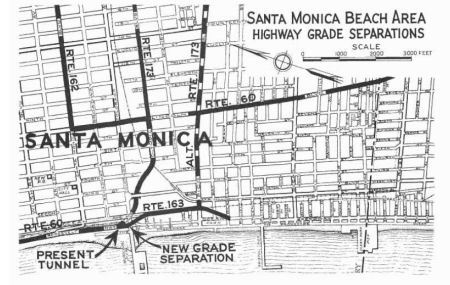 In 1933, Chapter 767 defined the following route as part of the state highway
system:
In 1933, Chapter 767 defined the following route as part of the state highway
system:
"Continue Roosevelt Highway from the point where it intersects with Santa Monica Canyon Road at and in Santa Monica to a point where, if so continued, it would intersect with Windward Avenue in Venica, Los Angeles, California. Said road is now commonly known and designated as Ocean Front and parallels the Pacific Ocean a short distance therefrom."
In 1935, this was added to the highway code as LRN 163, with the routing:
"[LRN 60] in Santa Monica, at the point where [LRN 60] leaves the ocean, to Windward Avenue in Venice via a road commonly known and designated as Ocean Park"
However, this was rapidly amended later in 1935 by Chapter 274 to be:
"[LRN 60] in Santa Monica, a a point southerly of the westerly extension of Wilshire Boulevard in Santa Monica to Windward Avenue in Venice via Prominade in Santa Monica and Ocean Front Walk in the City of Los Angeles"
In 1937, Chapter 50 reworded the definition again:
"[LRN 60] at a point near Colorado Avenue in Santa Monica to a connection with Windward Avenue in the city of Los Angeles"
The pre-1961 routing did not involve Venice Blvd. The route was a connection along the coast between the constructed LRN 173 (Olympic Blvd) and the alternate LRN 173 (Pico Blvd). It provides a highway closely following the ocean-front between Santa Monica and Venice. The 1937 routing involve the street currently called Moomat Ahiko Way (the curved road going under the bridge to the Santa Monica Pier, which was built by the state), and Ocean Blvd. The route continued S along Neilson and Pacific to Windward, which is a few blocks N of Venice.
In 1961, Chapter 1840 extended the routing to Route 173: "… to a
connection with Windward Avenue in the city of Los Angeles LRN 173 via Pacific Avenue and Venice Boulevard"
At this time, LRN 173 was the eventual freeway routing of I-10. Thus, the final version of the route ran from Route 1 near Colorado Avenue in Santa Monica to I-10 via Pacific Avenue and Venice Blvd. This corresponded to the 1964 version of Route 187. Since then, Route 187 has been truncated and only the portion E of Lincoln corresponds to present-day Route 187. The remainder does not correspond to any current state highways, nor does it appear this highway was signed as a state route.
© 1996-2020 Daniel P. Faigin.
Maintained by: Daniel P. Faigin
<webmaster@cahighways.org>.
 From Route
  Route 162
 Route 164