 The U.S. Bicycle Route System (USBRS) is a developing national network of bicycle routes connecting urban and rural communities via signed roads and trails.
Created with public input, U.S. Bicycle Routes direct bicyclists to a
preferred route through a city, county, or state. As of 2020, over 14,000
miles are currently established in 29 states and Washington DC – and
many routes are signed.
The USBRS was established in 1978 by the American Association of State Highway and Transportation Officials (AASHTO) for the purpose of "facilitating travel between the states over routes which have been identified as being more suitable than others for cycling." The National Corridor Plan for the (USBRS) was established by AASHTO in 2008. The Adventure Cycling Association (ACA) manages the USBRS route-designation process nationally for AASHTO. The system is developing through partnerships between transportation agencies, bicycle and trail organizations, and volunteers. Routes are nominated for official designation by state departments of transportation and approved by the American Association of State Highway and Transportation Officials (AASHTO). Designation of a U.S. Bicycle Route means that the state department of transportation and all jurisdictions along the route have given their support.
In California, routes are designed through the following process:
To donate and help build the USBRS, click here.
 The majority of USBRs have been designated since 2011, and the focus in the
last five years has been on designating routes rather than promoting them.
As expected, there are more plans and intentions to sign, map, and promote
the USBRS than are examples where it has already been done. The National
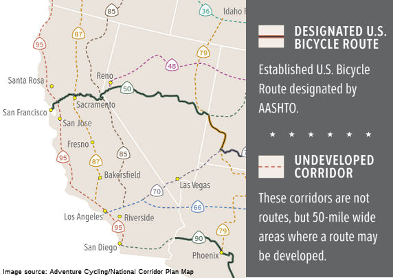
Corridor Plan may be found here; the image shows the plan for California:
(Image source: Adventure Cycling/National Corridor Map)
The National Corridor Plan is the blueprint for U.S. Bicycle Route development, and shows what the 50,000-mile network will look like when
complete. Corridors that have been developed into routes and officially
designated as U.S. Bicycle Routes are shown with dark solid lines.
Undeveloped corridors are shown with light dotted lines, and are generally
only concepts until a route is researched and designated. Corridors can be
added or changed depending on the opportunities and interests of a given
state. To date, 14,598 miles of U.S. Bicycle Routes have been established
in 29 states: Alaska, Arizona, California, Connecticut, Florida, Georgia,
Kentucky, Idaho, Illinois, Indiana, Kansas, Maine, Maryland,
Massachusetts, Michigan, Minnesota, Missouri, Nevada, New Hampshire, North
Carolina, Ohio, Pennsylvania, Tennessee, Utah, Vermont, Virginia,
Washington, West Virginia, Wisconsin, and the District of Columbia. The
Adventure Cycling page on the NCP provides a downloadable map.
(Source: Adventure Cycling/National Corridor Plan)
In California, the following routes are defined with ACA and have
Turn-by-Turn Maps:
(Source: USBRS Best Practices Final Report, August, 2016 (PDF))
USBR 50 (SFO to South Lake Tahoe): 17 jurisdictions: South Lake Tahoe, El Dorado County, Amador County, Plymouth, El Dorado, Hills, Folsom, Rancho Cordova, La Riviera, Sacramento, West Sacramento, Yolo County, Davis, Yolo, Fairfield, Solano County, Vallejo, San Francisco
USBR 66 (LA to Needles): 28 jurisdictions: Needles, Newberry Springs, Barstow, Victorville, Hesperia, San Bernardino, Rialto, Fontana, Rancho Cucamonga, Upland, Montclair, Claremont, Pomona, La Verne, San Dimas, Glendora, Azusa, Irwindale, Duarte, Monrovia, Arcadia, Pasadena, South Pasadena, Alhambra, Los Angeles, West Hollywood, Beverly Hills, Santa Monica
USBR 85 (Sierras): 18 jurisdictions: Siskiyou County, Shasta County, Truckee, Placer County, El Dorado County, Mariposa County, Madera County, Fresno County, Tulare County, Kern County, Kern, Lancaster, Los Angeles County, San Bernardino County, Yucaipa, Riverside County, Banning, San Diego County
In Lancaster: The proposed route enters through Rancho Vista
Boulevard, heads north on 50th Street West north to Columbia Way
(Avenue M) then turns west on Avenue L until the road ends at 90th
Street West, where it turns to go north past the City limits.
(Source: Antelope Valley Press, 7/8/2019)
USBR 90 (San Diego to Blythe) 5 jurisdictions: Blythe, Imperial County, San Diego County, Santee, San Diego
USBR 95 (Pacific Coast) 58 jurisdictions: Del Norte County, Crescent City, Arcata, Eureka, Humboldt County, Mendocino County, Fort Bragg, Fairfax, San Anselmo, Ross, Larkspur, Corte Madera, Mill Valley, Sausalito, Marin County, NPS Fort Baker, San Francisco, Daly City, Pacifica, Half Moon Bay, Santa Cruz, Santa Cruz County, Marina, Sand City, Seaside, Monterey, Monterey County, Morro Bay, San Luis Obispo, Pismo Beach, San Louis Obispo County, Lompoc, Goleta, UCSB, Santa Barbara, Santa Barbara County, Carpentaria, Ventura County, Ventura, Oxnard, Port Hueneme, Malibu, Santa Monica, Los Angeles County, El Segundo, Redondo Beach, Torrance, Carson, Long Beach, Los Angeles, Huntington Beach, Dana Point, San Clemente, San Diego County, Oceanside, Carlsbad (County Sign Route S21), Del Mar, San Diego
In Carlsbad, the route runs along Carlsbad Boulevard, the nearly
seven-mile stretch of road also known as Old Highway 101 or San Diego
County Sign Route S21.
(Source: San Diego Union Tribune, 11/16/2020)
The following are Concept Routes (without maps):
To see currently designated routes and download details maps, visit USBRS Maps and Route Resources at Adventure Cycling.
Adventure Cycling Association: U.S. Bicycle Route System
Caltrans: U.S. Bicycle Route System (USBRS)
 Forest Routes
  Highway Numbering Section Home
© 1996-2020 Daniel P.
Faigin.
Maintained by: Daniel P. Faigin <webmaster@cahighways.org>.