
 California Highways:
 ![[Postmile Sign]](images/postmile.gif) The
postmile is the means by which California tracks highway mileage. The
postmile starts at zero at the western or southern end of the route or at
the western or southern boundary of the county through which the route is
traveling. Mileage increases as you travel north or east and then restarts
at zero at the next county line. Postmiles are used as a reference system
to aid in the planning, design, construction, and operation of the state
highway system. The postmile marker is a black on white marker displaying
the route number, county, and mileage to the nearest hundredth of a mile
(see the illustration to the right). The mileage displayed on these
markers is based on the state highway routing in place on January 1, 1964,
with adjustments due to truncation or realignment. The postmile marker was
not intended to provide motorist information or guidance.
The
postmile is the means by which California tracks highway mileage. The
postmile starts at zero at the western or southern end of the route or at
the western or southern boundary of the county through which the route is
traveling. Mileage increases as you travel north or east and then restarts
at zero at the next county line. Postmiles are used as a reference system
to aid in the planning, design, construction, and operation of the state
highway system. The postmile marker is a black on white marker displaying
the route number, county, and mileage to the nearest hundredth of a mile
(see the illustration to the right). The mileage displayed on these
markers is based on the state highway routing in place on January 1, 1964,
with adjustments due to truncation or realignment. The postmile marker was
not intended to provide motorist information or guidance.
Postmiles show mileage on a per-county basis. If you use the Postmile Tool, you can also see the overall accumulated statewide mileage on each route. There are also highway logs that show the mileage accumulated by district, but those are not available through public websites. However, an alternate source is the Caltrans Traffic Volumes Handbook, which shows postmiles, based on the highway logs. By totaling up the postmile values for each county, you should come up with a rough mileage estimate.
Within any given post mile length, there may actually be more or less than an exact mile of distance. Sometimes, there is a letter before the mileage; these have the following meanings:
When a highway is realigned, there will be dual post-mile markers at the point of realignment. They will have the normal information as to highway number, county, but will have "AH" and "BK" designations that accompany the mileage. Something like AH 32.67 on one and BK 34.29 on the other. These designations stand for "ahead" and "back." So, the realignment (in the example) shortened the distance by 1.62 miles.
Post mile are posted in a variety of formats:
![[Postmile Bridge Sign]](images/postbridge.gif) Post
Miles. These are signs similar to the one shown to above. Post
miles are also shown on bridges, in the format shown to the right. This
sign shows the name of the bridge, the bridge number as is in the
Caltrans logs, and route number, the county, and the post miles.
Post
Miles. These are signs similar to the one shown to above. Post
miles are also shown on bridges, in the format shown to the right. This
sign shows the name of the bridge, the bridge number as is in the
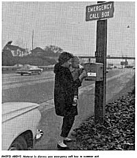
Caltrans logs, and route number, the county, and the post miles. ![[Call Box Image]](images/postcbox.gif) Call Boxes. Post miles are also encoded on call
boxes. The figure on the left shows a fictitious call box in San Diego
County. The post mile is encoded into the call box number. In this case,
the call box identifies itself as being near Post Mile 20.4 on Route
163. The specific policy at Caltrans is as follows:
Call Boxes. Post miles are also encoded on call
boxes. The figure on the left shows a fictitious call box in San Diego
County. The post mile is encoded into the call box number. In this case,
the call box identifies itself as being near Post Mile 20.4 on Route
163. The specific policy at Caltrans is as follows:
The CALL BOX sign (SG25) is used to designate call boxes on the county SAFE (Service Authority for Freeway Emergencies/Expressways) Call Box System. The special sign sizes are intended for use only on scenic highways, within designated coastal zones and National or State parks, to keep signing compatible with scenic values. The call box identification number is established by using the route number to the left of the hyphen. The first two numbers to the right of the hyphen are the post mile numbers (or three numbers if applicable); the last number locates the call box within the post mile. For northbound and eastbound routes, this number will be 2 for the first call box; 4 for the second; 6 for the third; and 8 for the fourth, within a given post mile. For southbound and westbound routes, this number will be 3 for the first call box; 5 for the second; 7 for the third; and 9 for the fourth, within a given post mile. A letter code may precede the post mile (R for realignment, etc.). Call boxes located in the median shall be designated by the letter “M” following the post mile, and Call boxes located on a transition or connector shall be designated by the letter “T” following the post mile.
Note that Call Boxes are not erected by CalTrans; the mere presence of a call box on a highway does not imply the highway is state maintained or a state route. Call Boxes are installed and maintained by the local Service Authority for Freeways and Expressways (SAFE), which is generally a division of the local transportation planning agency. Here are some examples:
With respect to call box numbering: For non-state highways, various encoding schemes are used. For some counties, the prefix is often taken from the name of the road. For example, the Los Angeles County Call Boxes on Mulholland Highway use the letters MH as the prefix followed by a mileage based suffix. In San Diego County, all of the call boxes have a 3 character prefix. Many have a "1" tacked on as the prefix, but there are some inconsistencies.
 The callbox system started on November 1, 1962, when
the world's first solar-powered emergency call system was installed on
10 miles of the Hollywood, Harbor, Santa Ana and San Bernardino
Freeways in the City of Los Angeles. The boxes, painted traffic yellow
and with a reflective surface so as to be visible at night, are
mounted on light standards at spacings of approximately one fourth
mile. The self-contained and self-generating call boxes are linked by
radio to the Los Angeles Police Department dispatching office so that
no communications lines need be run from the boxes to the central
station. There has been, on the average, one call for assistance by a
motorist through the system every two hours, day and night, since the
system began its operation. During the first month of operation, the
system was used by the motorist to carry 70 percent of his requests to
the police department for assistance.
The callbox system started on November 1, 1962, when
the world's first solar-powered emergency call system was installed on
10 miles of the Hollywood, Harbor, Santa Ana and San Bernardino
Freeways in the City of Los Angeles. The boxes, painted traffic yellow
and with a reflective surface so as to be visible at night, are
mounted on light standards at spacings of approximately one fourth
mile. The self-contained and self-generating call boxes are linked by
radio to the Los Angeles Police Department dispatching office so that
no communications lines need be run from the boxes to the central
station. There has been, on the average, one call for assistance by a
motorist through the system every two hours, day and night, since the
system began its operation. During the first month of operation, the
system was used by the motorist to carry 70 percent of his requests to
the police department for assistance.
In December 2011, it was reported that callboxes are now being removed from many state highways, due to the cost of maintenance and the increasing use of cellular phones. According to a Metropolitan Transportation Commission study, the number of calls placed through the emergency phones fell by about 80 percent between 2001 and 2011. The average call box gets used 8.9 times a year. In the San Francisco Bay Area (i.e., the area controlled by the MTC), the plan is to maintain an even distribution of one call box per 2 miles instead of the current one per mile, Heavily used boxes will be spared. A recent study estimates the slimmed-down call-box network can save $1.9 million over the next 10 years. The money would be used to fund other safety initiatives, including Freeway Service Patrol tow trucks that rove the highways during commute hours and 511 Freeway Assistance, which sends emergency aid to drivers who call the 511 regional transportation information service.
In June 2015, it was reported that the peak usage of the call box
system was in the early 1990s, when stranded Orange County motorists
logged 8,400 calls per month. Since then, usage plunged 98%, to about
205 calls in a month, according to a 2015 Orange County Transportation
Authority report. Motorists are more apt to dial 911 or 511 on a
cellphone. This is leading counties to drop the number of callboxes. A
bill in Sacramento would shift money from call boxes to other motorist
programs, and AT&T plans to dump the outdated 2G network the
county’s call boxes rely on at the end of next year. Robo-calls
– placed to make sure the county’s 534 boxes still work
– outnumber human calls by 12 to 1, according to an analysis of
a recent call box phone bill. Actual motorists place an average of
three to five calls daily, according to Rosamaria Valdez, a dispatch
supervisor with the California Highway Patrol. The annual cost for
call box upkeep is roughly $320,000, and the monthly phone bill runs
about $480. Simple math shows that works out to about $132 per call,
not taking into account the cost of dispatchers.
(Source: OC
Register, 6/4/15)
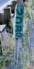
![[Postmiles on Pole]](images/postpole.gif) Lightposts. Post miles are also encoded on light
poles (and sometimes on gantry poles). The image to the right shows a
fictitious marking on a pole. To the untrained observer, this appears to
be a pole number. In actuality, it is a post mile marker, indicating
that the pole is located at mile point 32134 on the
current highway. Poles always use 3-digit precision.
Lightposts. Post miles are also encoded on light
poles (and sometimes on gantry poles). The image to the right shows a
fictitious marking on a pole. To the untrained observer, this appears to
be a pole number. In actuality, it is a post mile marker, indicating
that the pole is located at mile point 32134 on the
current highway. Poles always use 3-digit precision. In some counties, the designation "MTN" is used instead of the county code. This indicates a mountain road. Only a few counties do this, such at Tulare county.
![[Standard Mile Marker]](images/D10-3.gif) California
does not regularly use mile markers (although a few are installed as
either an experiment or for special purposes), as are found in other
states. These modern markers, as illustrated to the left, are specified in
the MUTCD. California may explore adding this once the current exit
numbering project is completed, but even if they are added, they
will only be for the convenience of the driving public. For primary
mileage purposes, the post mile system described above is used.
California
does not regularly use mile markers (although a few are installed as
either an experiment or for special purposes), as are found in other
states. These modern markers, as illustrated to the left, are specified in
the MUTCD. California may explore adding this once the current exit
numbering project is completed, but even if they are added, they
will only be for the convenience of the driving public. For primary
mileage purposes, the post mile system described above is used.
Here's a history of mile markers in California, prepared by Joe Rouse of Caltrans. At the time of this writing, Joe was in charge of the exit numbering program for Caltrans.
It is unclear when the concept of the milepost was introduced. The 1961 MUTCD encouraged the use of mileposts.
"It is recommended that (mileposts) be simple panels without border, having 4 to 6 inch numerals and no other legend. The numerals should be black on a white background or white on a green or black background with suitable reflectorization."
Special guidance was given for mileposts on Interstate routes:
"On the Interstate system it is prescribed that Mileposts shall be installed...on both sides of the highway, with zero mileage at south or west State lines, or at junctions where routes begin. The mileage numbering is to be continuous within any State. The Milepost panels are green, with 6-inch white reflectorized numerals."
 In January 1965, the Division of Highways (later to
become Caltrans) introduced a mileage marker for use on Interstate
freeways, in keeping with the provisions given in the MUTCD. This occurred
after publication of a signing policy review in 1964, which considered
several design alternatives for mileposts. One of these was an oval
"paddle" design, based on one then being used in Michigan, which would
have had the (Series D) numerals (whole miles only) ranged horizontally on
an oval blank. A good picture of the spread in milepost designs is given
by an I.I.H.S. publication, 'Mileposting' (1967), which has pictures of
typical mileposts in each state then using them. Caltrans selected the
G61R design, a white on green marker similar in size and shape to the
mileage marker. It displayed mileage to the nearest tenth of a mile, with
6-inch whole numbers and a 4-inch decimal. The marker gave no other
information and had no border. [See the picture to the right, courtesy of
Jason Elliot (Jonathan Ledbetter) of Oregon
Roads and Reno
Roads] The policy for the G61R was as follows:
In January 1965, the Division of Highways (later to
become Caltrans) introduced a mileage marker for use on Interstate
freeways, in keeping with the provisions given in the MUTCD. This occurred
after publication of a signing policy review in 1964, which considered
several design alternatives for mileposts. One of these was an oval
"paddle" design, based on one then being used in Michigan, which would
have had the (Series D) numerals (whole miles only) ranged horizontally on
an oval blank. A good picture of the spread in milepost designs is given
by an I.I.H.S. publication, 'Mileposting' (1967), which has pictures of
typical mileposts in each state then using them. Caltrans selected the
G61R design, a white on green marker similar in size and shape to the
mileage marker. It displayed mileage to the nearest tenth of a mile, with
6-inch whole numbers and a 4-inch decimal. The marker gave no other
information and had no border. [See the picture to the right, courtesy of
Jason Elliot (Jonathan Ledbetter) of Oregon
Roads and Reno
Roads] The policy for the G61R was as follows:
"Use the G61R to indicate the mileage on Interstate routes from the south or west termini. These signs should be placed at 0.2-mile intervals in urban areas, 0.5 in suburban and one mile intervals in rural areas."
The G61R was actually developed in 1960. There were two versions. The G61R-1 had white 6 inch whole numbers and a white 4 inch decimal on a green background and no other information. The G61R-2 was identical to the G61R-1 but it added a white 3 inch county abbreviation at the top, much like what we see on California postmile markers today. If the mileage had more than 3 digits, the county abbreviation was to be removed. The G61R-2 was not to be used on Interstate routes.
 An
example of a G61R (illustrated at the right, if you couldn't see the one
above) may be seen along I-80 travelling east towards Reno from Truckee,
at about 1–1½ miles from the California-Nevada border on the
California side, there is one of the original mile marker signs. This sign
has a dark-green background with darkened text and reads 2080.
The numbers on the side are rotated the same direction and way as modern
postmiles. There is/was another along I-80 eastbound in Placer County,
between PM 36.0 and 37.0: it reads 1430. According to Eric
Buchanan's Highway Photo Page, there is another one around mile 155
(probably around PM 48.0 Placer or so) as well as one on BR 80 "just past
99 south."
An
example of a G61R (illustrated at the right, if you couldn't see the one
above) may be seen along I-80 travelling east towards Reno from Truckee,
at about 1–1½ miles from the California-Nevada border on the
California side, there is one of the original mile marker signs. This sign
has a dark-green background with darkened text and reads 2080.
The numbers on the side are rotated the same direction and way as modern
postmiles. There is/was another along I-80 eastbound in Placer County,
between PM 36.0 and 37.0: it reads 1430. According to Eric
Buchanan's Highway Photo Page, there is another one around mile 155
(probably around PM 48.0 Placer or so) as well as one on BR 80 "just past
99 south."
Note: In October 2015, it was reported that the 208.0 G61R postmile marker along I-80 just west of the state line was removed whenever CalTrans did road reconstruction along the portion between Farad and the state line in the late 2000s. However, as of mid 2013, there's still an old postmile marker that exists on I-80 WB near Newcastle.
In 1970, FHWA mandated the use of milepost exit numbering on Interstate freeways. The 1971 MUTCD required the use of milepost markers and milepost exit numbering on all freeways and introduced a standardized milepost marker. That form of G61R was removed from the state Traffic Manual in 1971. There was no explanation given for its removal, although it is most likely due to the fact that it was not in compliance with the MUTCD. A review of the sign specs showed that the G61R was actually revised twice in 1971. The first revision, dated March 10, 1971, changed it into a 36 inch by 28 inch panel with white letters and border and green background. It had the text MILE at the top, with the mileage placed horizontally, not vertically. This version did not last long. There is a handwritten note on the spec sheet that says "Obsolete." A new version of the G61 was developed in December of that year. This version is the same as the white on green mileposts we are familiar with today. There was no revision date for this version of the G61, and no note stating it was obsolete. This implies that it was available for use if the state decided to implement mileposts and exit numbering. It may still remain available for use.
In 1971, the Division of Highways conducted a pilot project on 5 different routes in the Los Angeles area to evaluate the benefits of exit numbering. No milepost markers were installed in this project. 313 signs were installed for 141 exits. A few of these signs remain in place on these freeways, but the numbers are slightly different from the current exit number determinations. The study recommended that exit numbering be installed on all freeways in urban areas in the state. However, there were concerns about the costs of adding and maintaining thousands of new signs on the highway system. There was also the question of whether to convert from the postmile system to a milepost system, which would have required changes to numerous databases. For these reasons, no programs to install additional exit numbering and mileposts were conducted. The study recommended that mileposts be established only on rural freeways, but not urban freeways. This was due to concerns about the accurate placement of the mileposts in urban areas.
In 1999, the California State Senate requested that Caltrans conduct another study regarding the cost of implementing mileposts and exit numbering. In 2001, Caltrans decided to implement an exit numbering program but not place milepost markers. The statewide mileposts and the exit numbering would be determined by calculating the cumulative postmiles of the route. The existing postmile system would remain in place and would continue to be the basis for highway data. The exit numbering system was solely for motorists' benefit. Exit number installation began in early 2002 and continues. The initial completion date for this project was set as November 2004. However, budget constraints have slowed the project, and the deadline has been extended to November 2008, which matches a compliance date for exit numbering in the 2000 MUTCD.
At the time the exit numbering program was implemented, Caltrans was in the process of adopting the 2000 MUTCD to replace the state Traffic Manual. A special California supplement would also be developed for the MUTCD as part of this process. Caltrans eventually adopted the 2003 version of the MUTCD in May 2004. Section 2D.46 of the 2003 MUTCD discusses milepost markers (now known as reference location signs). Section 2E.54 discusses enhanced reference location signs, which in addition to mileage, also show the route shield and cardinal direction. This section also states that milepost markers must be used on all freeways (the enhanced marker is optional). The California Supplement to the 2003 MUTCD changes the mandatory milepost requirement in Section 2E.54 to an option. FHWA did not agree with this change, but approved it as part of the Supplement.
The department's policy is to complete the freeway exit numbering project and then consider the installation of milepost markers. Cost remains the primary issue. If they are installed, it is highly likely that they would be for motorists' convenience only, much like the exit numbering. The existing postmile system will probably remain in place and be the primary reference system for Caltrans usage. Note that California would not be the only state that uses dual mileage systems; Nevada also does this.
Interestingly, there is one recently completed segment of freeway in California that has milepost markers on it. These markers may be found on the new Mojave Bypass, in Kern County on Route 58.
© 1996-2020 Daniel P.
Faigin.
Maintained by: Daniel P.
Faigin <webmaster@cahighways.org>.
 Exit Numbers
 Business Routes